The impact of our disappearing snowpack on Lake Mead

It’s looking increasingly likely that some of this year’s “bonus water”, extra releases from Glen Canyon Dam to bolster supplies in Lake Mead outside Las Vegas, is evaporating with our dwindling Rocky Mountain snowpack.

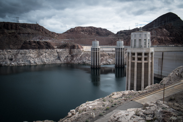
Hoover Dam, February 2015

Hoover Dam, February 2015

The folks at the Bureau of Reclamation have been careful since the beginning in telling us that the bonus water was no guarantee, but lots of people (myself included) have been treating the extra water as a given. It is not.

This is one of those Colorado River management issues for which the details are buried in arcane operating rules, but it boils down to this: In a “normal” year, the Bureau of Reclamation releases 8.23 million acre feet from Glen Canyon Dam, down through the Grand Canyon, and into Lake Mead. If conditions are good enough upstream, the rules allocate a bit of bonus water, and lots of people were expecting that to mean 9 million acre feet this year. But with a dwindling snowpack, that is looking less likely.

Here’s how the Bureau tried to warn us about this possibility last August:

Based on the August 24-Month Study, which is the Bureau of Reclamation’s monthly operational study, the water release from Lake Powell to Lake Mead for water year 2015 will be 8.23 million acre-feet (maf). This is an increase from the 2014 release of 7.48 maf, which was the lowest release since Lake Powell filled in the 1960s….

Under the 2007 Interim Guidelines, another review of the conditions at Lake Powell and Lake Mead will occur in April 2015. Based on an analysis of those projections in the April 24-Month Study, Lake Powell’s water releases could be increased to 9.0 maf for water year 2015.

But because the underlying studies and operating plans pegged that 9 million acre feet as the most likely outcome, a lot of us jumped to conclusions. Bad on us, because the preliminary numbers that are publicly available suggest it’ll be well below that 9 million when we see the final reports next week.

Yuma: one more for the road

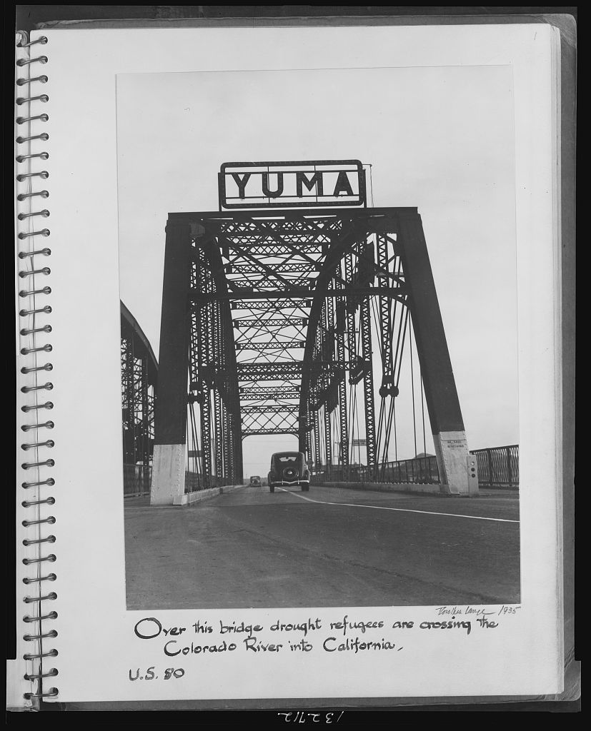
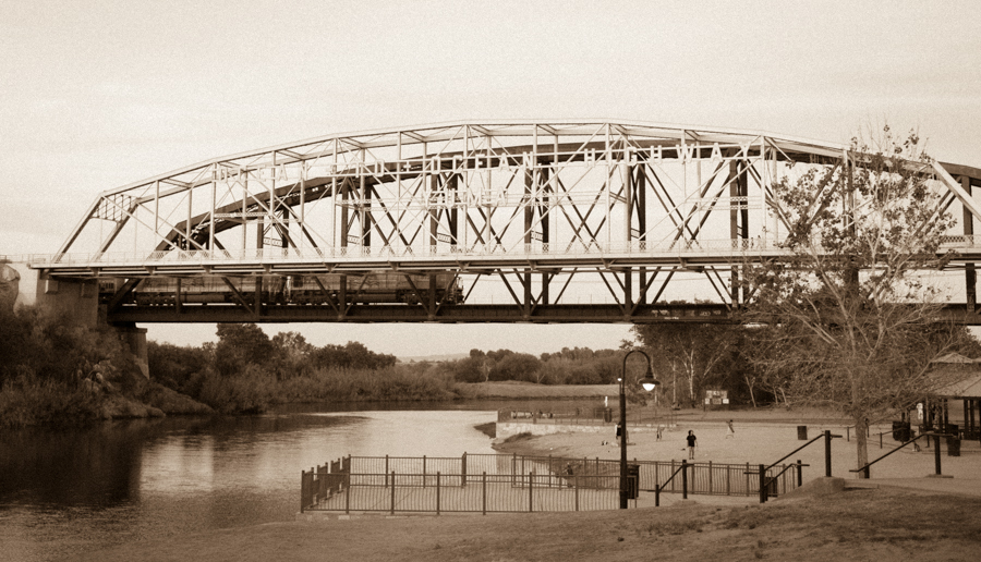
“Over this bridge drought refugees are crossing the Colorado River into California.”
– Dorothea Lange, 1935

Dorothea Lange, Yuma crossing, 1935

Dorothea Lange, Yuma crossing, 1935


One more great bit of American history as I get ready to head off to Yuma. I love this picture. From the Library of Congress’s remarkable collection of Dorothea Lange’s work in the American Desert during the Depression.

The problem with the “running out of water” rhetoric

I stumbled this evening across this 2009 piece by the Public Policy Institute of California which seems quite timely:

The Myth

The popular press often propagates the myth that California is running out of water. As a recent example: “Have you seen Lake Oroville lately? If so, you know California is running out of water” (Speer, 2008). This myth stems from rigid notions that there is no flexibility in water management and that the economy will grind to a halt if shortages occur. It persists despite ample historical evidence and numerous economic and technical studies showing that Californians can adapt successfully (albeit at some cost and inconvenience) to living in an arid region with variable and changing water conditions. By implying that Californians cannot adapt, the “running out of water” myth discourages efforts to manage water resources more efficiently.

How the Myth Drives Debate

The notion that California is running out of water is effective in raising alarm about serious water problems but encourages a simplistic and sometimes counterproductive attitude toward solving them.

Yuma

Colorado River at Yuma, by John Fleck

Colorado River at Yuma, by John Fleck

Getting ready for a reporting trip next week to Yuma, I’ve had occasion to revisit a recent favorite Colorado River water book, Robert Sauder’s The Yuma Reclamation Project.

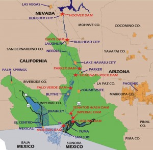
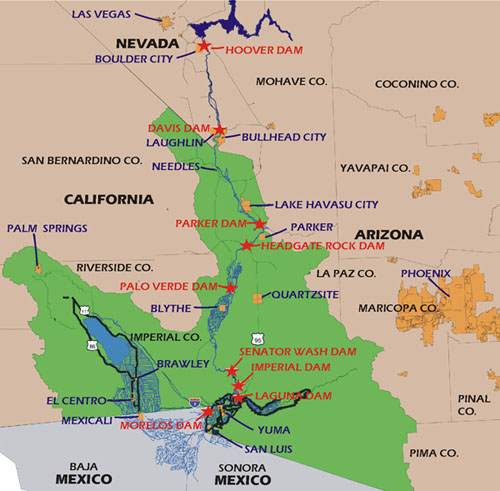
Yuma area, courtesy USBR

Yuma area, courtesy USBR. The green is the jurisdictional area of the Burea’s Yuma Area Office

Yuma is the last thing the Colorado River sees as it leaves the United States and disappears into the agricultural diversion canals of the Mexicali Valley, there to grow cotton, alfalfa and wheat. I’m headed there to see some environmental work being done on the lower river on the U.S. side of the border, but mainly to learn more about how Yuma County farmers use Colorado River water to grow food.

In the story of the Colorado River, Yuma is often overshadowed by its more muscular neighbor to the west, California’s Imperial Valley. But I have a personal fondness for Yuma, maybe because it actually puts its feet in the river (see picture above from when I was there last year). There’s a lovely city park on the river beneath the old bridges, a very well used park. To the east, upstream from where the photo was taken, the community has built a wetland project that’s great for birding. I’m taking binoculars!

With good soil, abundant sunshine and a reliable source of Colorado River water, the Yuma area farmers are sitting on what seems to be, per acre, the most valuable farmland in the Colorado River Basin. By county, it’s the second largest lettuce producer in the country, behind the Salinas Valley of California (Monterey County). But because Yuma farmers can grow during winter months when Salinas farmers can’t, Yuma dominates the U.S. domestic winter lettuce market.

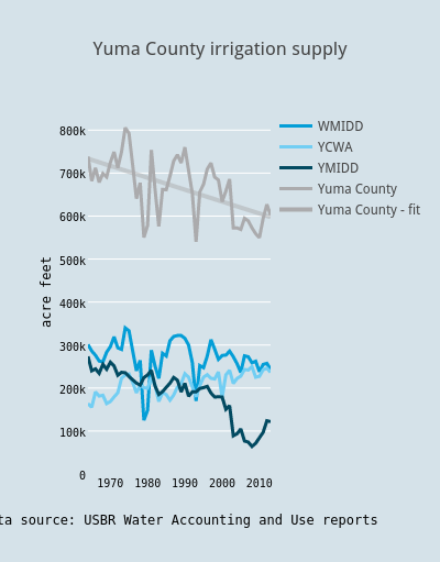
One of the most interesting features of farming in Yuma County (and this also applies to the other regions irrigated with water from the Lower Colorado River) is the relative reliability of supply. Sara Gerlitz and Chris Babis, in the University of New Mexico’s Water Resources program, are helping me look at water data over the last half century on that part of the river to try to better understand how the system can be brought into balance, and the graphs for Yuma County tell an interesting story (these are the area’s three large ag districts, so this doesn’t capture everything, but I think it’s getting the basic picture):


Yuma County irrigation supply

Two things have popped out of the data for me. One is the slow, long term decline. The second is the relative reliability of the supply over time.

One of the reasons I’m headed down is to meet with folks involved with the county’s big irrigation districts – Wellton-Mohawk (to the east of Yuma in the Gila River valley), Yuma Mesa (YMIDD in the graph) and the Yuma County Water Users Association. Each has a different geography and a unique story, but they share in common a reliability of supply that is unusual in arid climate surface water irrigation. Don’t get too caught up in the squiggles. A lot of arid climate farmers dependent on surface water would be seriously envious of squiggles that small.

As early users of Colorado River water, they have relatively senior water rights. With the multi-year storage behind Hoover Dam upstream, those senior rights mean that under the current water allocation rules, their supply remains reliable longer than a lot of other users in the basin who are more directly impacted by drought and climate change shortfalls. This is as close as you’ll get to a “drought proof” water supply in the arid southwest. Not surprisingly, people down there tend to look over their shoulders as a result, fearing that rich city folk will come after their water.

You also can see that, to the extent that the system is currently out of balance (hence the great emptying of Lake Mead), it’s not the fault of the Yuma County farmers. Their use is going down. (I think this is a land use shift story, primarily driven by YMIDD – that’s one of the things I’m hoping to better understand when I’m down there next week.)

The question of how Yuma got here is a fascinating one as we think about the future of water management in the Colorado River Basin. There’s a tendency to focus on the physical plumbing, which is pretty cool as water engineering goes – Laguna Dam, then Imperial, the amazing siphon under the river at Yuma, the saga of, and solutions to, Wellton-Mohawk’s groundwater pumping and salinity problems. But UC Santa Barbara anthropologist Casey Walsh argues that you can’t separate the physical from the institutional plumbing:

Water works possess the main characteristics of infrastructures: they are built into the landscape; they are shared by almost everyone; they serve both private and public ends, enabling the entire society to work more productively, ensuring better health, better standard of living, and so on. But this thumbnail definition allows us to think about social institutions and organizations as infrastructures as well. Social infrastructures of water include laws and the legal system, water user associations, and the bureaucracies and institutions of water management, whether private or public.

The need to understand this second piece, what Walsh calls “social infrastructures” and I’ve been calling “institutional plumbing” (I think I may like Walsh’s language better?) is what I love about Sauder’s book. It’s the story, told in careful detail, of the invention of a modern way of living in the desert – how settlers saw the land and the sun and the water and realized that if you could combine them, you’d have something. It describes how they elbowed aside native communities and then struggled to invent new ways of organizing themselves – private companies, public irrigation districts, U.S. federal government help. It is at times painful and at times comical – they had no idea how to build irrigation systems in a desert on the banks of a flooding river. The story of the Colorado River is often told in sweeping, basin-wide narratives (of either heroic irrigation pioneers or scoundrels fleecing the taxpayers). But it is in that process of organization irrigation district by irrigation district, mostly by people with good intentions and imperfect knowledge, that the story lies. That’s what I love about Sauder’s book, because as you get down to a more intimate scale, the story of the development of the Colorado River becomes more comprehensible.

On climate, a call for more social science

David Victor on the need for better inclusion of social science in the work of the Intergovernmental Panel on Climate Change:

The IPCC must overhaul how it engages with the social sciences in particular…. Fields such as sociology, political science and anthropology are central to understanding how people and societies comprehend and respond to environmental changes, and are pivotal in making effective policies to cut emissions and collaborate across the globe.

But Victor points out why the problem is in part driven by shortcomings in the social sciences themselves:

Because societies are complex and are in many ways harder to study than cells in a petri dish, the intellectual paradigms across most of the social sciences are weak. Beyond a few exceptions — such as mainstream economics — the major debates in social science are between paradigms rather than within them.

Preliminary Rio Grande runoff: 55 percent through Central New Mexico

update: The preliminary human-in-the-loop forecast is substantially better than the automated one, at 55 percent. But still terrible.

previously: The preliminary Rio Grande forecast for April 1 is just 33 percent of the 1981-2000 average, a dramatic reduction since the March 1 forecast that shows just how abysmally warm and dry the month of March was here in New Mexico and the headwaters regions of Colorado to our north.

The forecast point here is Otowi, between Santa Fe and Los Alamos, which is the point at which the river enters the center of the state. The forecast is very preliminary, based on the automated computer model forecasts. The human-in-the-loop forecast should be out any day, but it’s not likely to be terribly different.

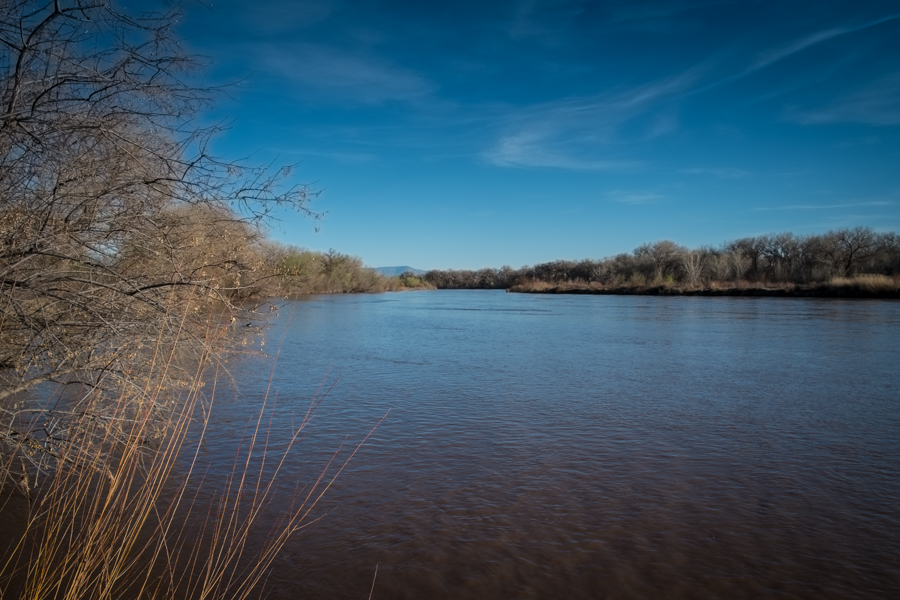
The Rio Grande through Albuquerque has been high recently, because what snow we have is melting early

The Rio Grande through Albuquerque has been high recently, because what snow we have is melting early

Flow out of Colorado has already likely peaked, I’m told. It usually doesn’t peak until May. There is some hope for a second peak as water melts out of the Sangre de Cristo’s, the southern Rocky Mountain chain extending from Taos down to Santa Fe. If that happens, water managers may be able to add some stored water for a pulse flow for the endangered Rio Grande silvery minnow, to encourage spawning. Maybe.

The fish and the environment will have the toughest year. The municipal users will be fine. Albuquerque has stored water in Abiquiu Reservoir from previous years, and incredible conservation success (down to 134 gallons per person per day compared to something like 250 20 years ago) means demand is far less. And Albuquerque has groundwater to fall back on.

Farmers in the Middle Rio Grande will have a tougher year, with little storage to fall back on.

The environment will have the toughest time. When there’s no water, there’s no water.

Some difficulties in setting up water markets

Water markets – willing buyers and willing sellers, to get water moved from places with a lot to places that need it really bad – are a hot topic of conversation right now, what with California’s big drought and all. Brian Devine at the University of Colorado has a nice post up this week explaining why they’re hard to implement in practice. Brian has a lot of good examples of the practical problems of implementing such a market, not the least of which is the physical movement of the water. I’d like to single out one small but incredibly important point:

I go to this mythical new water market and sell my consumptive use (let’s assume I actually know what this is, unlike 90% of the farmers out there).

This seemingly trivial problem – how much water am I actually using, and how much is saved by not irrigating this year? – is not trivial. For my book research, I’m looking right now at an example in Arizona that’s showing great promise, but the investment in calculating this bit – how much water saved? – is a huge effort, and coming up with an answer that everyone agrees with and trusts is a crucial piece of success. This is the sort of thing that takes a lot of work to get right if we’re going to make water markets work.

Brian’s entire post is worth reading.

Colorado River Basin forecast: where’d that 1.3 million acre feet go?

The April-July runoff forecast into Lake Powell, on the Arizona-Utah border, is just 52 percent of the long term mean, according to new numbers out today from the Colorado Basin River Forecast Center.

That is roughly 1.3 million acre feet less water flowing into Lake Powell than the forecast of just a month ago, the result of a hot, dry March. That means at the end of said runoff period, Powell will be roughly 13 feet lower than it would have been otherwise, according to my half-assed amateur calculation (danger, danger, journalist doing math! – the pros at the Bureau of Reclamation will give us a more reliable number next week).

It’s important to remember what this means. Unlike in California, where farmers directly downstream from reservoirs get shorted when inflow is lousy, Powell is a giant bathtub in a super-plumbed system. While farmers using headwaters streams and rivers to irrigate could see shortages as a result of the lousy snowpack, the real impact for the Colorado River Basin system as a whole is more buffered. But in the long run, it increases the chances of seeing a formal shortage declaration in coming years, which would reduce allocations to Arizona and Nevada.

California drought: Jerry Brown doesn’t have a knob to turn

Yesterday’s executive order from California Gov. Jerry Brown (pdf here) illustrates a crucial issue about water governance, the issue of the scale at which we manage our water.

The headline news from Brown’s announcement – “First Ever Statewide Mandatory Water Reductions.” But what does “mandatory” mean here? Here’s the explanation from Craig Miller, who’s covering California drought for KQED in San Francisco:

In other words, municipal water in California is managed at a different scale – of 400 (or maybe 3,000? see below) municipal water agencies. Here’s how Matt Weiser and David Siders, in the Sacramento Bee, described what happens next:

Brown’s executive order directs California’s more than 3,000 urban water providers to collectively cut their water use by 25 percent compared with 2013. The State Water Resources Control Board is expected to impose the new restrictions by mid-May, setting a different target for each agency depending on how much water its customers use per capita and conservation progress since last year.

What “mandatory” actually means here, as it cascades down from the Governor to the SWRCB to the individual utilities to their customers is not clear. Each of those entities is already either succeeding or failing, managing well or poorly, struggling or not, and the most Gov. Brown can do here is give them a little nudge.

This is not a criticism of Gov. Brown. As Faith Kearns put it, expecting a single solution here is wrong:

Rather, the solutions are likely to flow up from the bottom, as each group of water users deals at its local level with its local problems. But saying Gov. Brown doesn’t have a knob to turn may underestimate his extraordinary political skill. The single nob he does have to turn is the power to make dramatic statements that draw a lot of attention to the problem. That in turn may enable that bottom up push for solutions. And that is the knob he turned on Wednesday.

(Thanks to my University of New Mexico colleague Bruce Thomson, who in the New Mexico context introduced the concepts of “knobs to turn” to our water policy dialogue here.)

Where will California’s water shortfalls hit?

Craig Miller at KQED has a useful roundup of what sort of shortfalls California water users might see this summer as a result of drought:

  • Ag: “More than 400,000 acres of farmland were fallowed last year because of scarce water. Credible sources have estimated that figure could double this year.” That’s in the neighborhood of 10 percent of California’s irrigated acreage.
  • Big munis will have to cut back, but will not run out of water. Some rural systems will be stressed: “Cowin hastens to add that ‘the vast majority of our citizens will not run out of water,’ some already have, mostly in rural areas where wells have gone dry.”
  • Pressure on aquifers to make up for surface shortfalls will grow: “Groundwater resources will be stressed even more, as water-constrained farmers turn up the pumps to offset cuts in allocations from state and federal water projects.”