River Beat: Colorado River Forecasts Continue to Drop

Update: Tom Pagano points out in the comments, I think correctly, that I’m incorrectly interpreting the data because the most recent data points cover a shorter period of time. So take this with a grain of salt….

*******

At the risk of overanalyzing a single short term data point, the weekly model runs from the Colorado Basin River Forecast Center this week are all down on the major rivers of the upper basin:

Best not to get too hung up on specific numbers. These are model guidance numbers, not a full-on vetted forecast. It’s the trend that matters, and it continues to be heading down.

River Beat: Yuma Desalting Plant Dedication

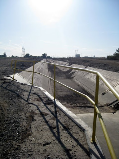
outflow channel from the Yuma Desalting Plant, which will begin its test phase next week

outflow channel from the Yuma Desalting Plant, which will begin its test phase next week

Joyce Lobeck reports on yesterday’s festivities in Yuma to mark next week’s start of the Yuma Desalting Plant test run:

On Monday, the desalting plant will be started up for a yearlong demonstration run that will produce about 29,000 acre-feet of desalinated water. That means 29,000 acre-feet of water – enough to serve 116,000 people for one year – can remain upriver in Lake Mead.

Not only that, the operation at one-third capacity will provide valuable information about the plant’s condition and performance. This information will be critical in future decisions on whether or how to operate the plant on a long-term basis to stretch water resources in the desert Southwest, said Mike Connor, commissioner of the U.S. Bureau of Reclamation.

29,000 acre feet on a 16.5 million acre foot system is a rounding error, but the symbolism here is not. In the realm of political signaling, it’s worthy of note that two of the biggest shots in western water were there – the Southern Nevada Water Authority’s Pat Mulroy and Mike Connor, head of the U.S. Bureau of Reclamation. Add in the 70,000 acre feet in estimated annual water savings associated with the Drop 2 storage reservoir nearly completed on the All-American Canal (a bonus add-on to yesterday’s ceremony) and you’re starting to talk about real water here. But more importantly, these two projects, and the symbolism surrounding them, provide some picture of the engineering and institutional approaches Colorado River water managers see going forward for this horribly over-allocated river.

I don’t whether it was an omission in the story, or in the event, however, but it’s potentially noteworthy that there was no mention of the folks working on the Cienega de Santa Clara, which represents the environmental tail end of the problems happening upstream.

Stuff I Wrote Elsewhere: Lasers on the Moon

Some days you have to write about nuclear waste. Some days you have to write about water contamination in the Rio Grande. And some days you simply can’t avoid writing about shooting lasers at the moon (sub/ad req):

Scientists using a NASA satellite and a New Mexico telescope have found a missing Soviet spacecraft on the moon.

NASA scientists saw a white dot in images released last month from the Lunar Reconnaissance Orbiter in the general area where Lunokhod 1 was thought to have been lost back in 1971.

Lunokhod 1 is a wheeled robotic rover about the size of a riding mower, dispatched during the height of the U.S.-Soviet Cold War race to explore the moon. The robot — its name roughly translates as “moon walker” — wandered a patch of lunar soil for nearly a year before contact was lost in September 1971, said Tom Murphy, a physicist at the University of California San Diego.

Murphy, who has been hunting for Lunokhod 1 for years, used a telescope at Apache Point Observatory in southeastern New Mexico to scan the spot April 22.

“Within 10 seconds, we knew we found it,” said Murphy in a telephone interview Tuesday.

River Beat: Monitoring the Cienega de Santa Clara

The Bureau of Reclamation’s Yuma Desalting Plant is scheduled to begin its operational test phase next week. In preparation, a U.S.-Mexican team is ramping up its monitoring efforts at the Cienega de Santa Clara, an accidental wetland in what was once the Colorado River delta. The Cienega is the inadvertent product of U.S. ag drainage that was too salty to put directly into the Colorado River. It’s diverted instead into a channel that bypasses most of the delta, ending at once was empty salt flats. It’s now a small but thriving ecosystem, as Mari Jensen explains in a nice piece on what’s happening in the Cienega now and what happens next:

Courtesy Francisco Zamora

Courtesy Francisco Zamora

The cienega currently receives about 107,000 acre-feet of agricultural runoff water per year. When the YDP is running, the cienega is projected to receive about 67,000 acre-feet of runoff plus about 10,000 acre-feet of effluent from the plant….

“I think we’ve got a good idea of what the natural range of variability is,” [University of Arizona researcher Karl Flessa] said. “So the question now is: When one-third of the water gets taken out to go through the Yuma Desalting Plant and a salty brine starts flowing toward the cienega instead, how will that affect the health of the cienega?”

To answer that question, the researchers placed instruments that record water quality and water level every 30 minutes at 20 locations all over the cienega. Some instruments are in open water, some are along the edges of the marsh, and others are deep in cattail thickets.

The Cienega raises interesting issues about how to maintain ecosystem flows across an international when no one quite owns the environmental problem. If this were in the United States, the actions of a U.S. government agency would be subject to the Endangered Species Act and other environmental laws.

But it’s in Mexico.

Past reporting on the Cienega and the YDP here, here and here.

River Beat: Colorado River Basin Supply and Demand

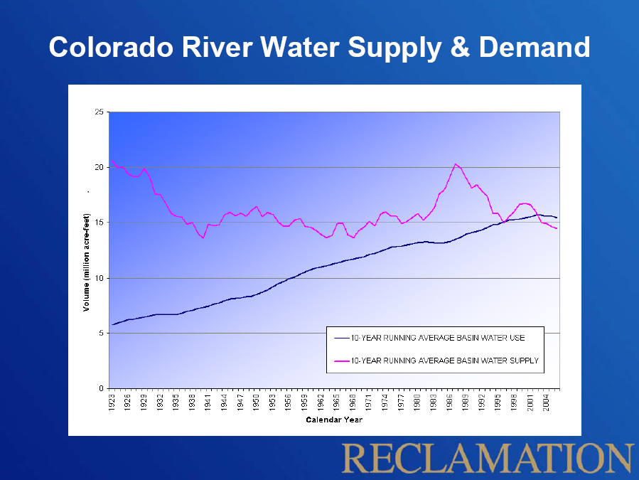
There’s a U.S. Bureau of Reclamation graph making the rounds that captures the core issue going forward on the Colorado River Basin.

Colorado River Basin Supply and Demand, courtesy USBR

I first noticed it in Jennifer Pitt’s congressional testimony in early April. At the “Implications of Lower Lake Levels” symposium I just attended in Las Vegas, it showed up in three different talks (Terry FulpBrad Udall and Paul Miller – all links to PDFs of their slides).

It also features prominently in the proposal submitted last year by the Colorado River Basin states (another big PDF) that evolved into the Colorado River Basin Water Supply and Demand Study now underway. Here’s how that proposal described the problem in a nutshell:

The Basin States include some of the fastest growing urban and industrial areas in the United States. Nevada, Arizona, and Utah are each ranked among the five fastest growing states in the country. The continued growth and sustainability of the communities and economies of metropolitan areas such as Albuquerque, Denver, Las Vegas, Los Angeles, Phoenix, Salt Lake City and San Diego is tied to future water availability from the Colorado River. Based on a compilation of population projections from various water districts throughout the Basin States, the population dependent on the Colorado River and its tributaries could grow by 25 million over the next 40 years, leading to an increase in water demand of as much as 5 maf annually. Demand for water for other uses including the environment, recreation, and Native American water rights settlements also continues to increase. Potential future increases in temperatures in the Basin, as have been observed in most of the Basin over the past 30 to 40 years, would increase evaporation-transpiration from vegetation, leading to further increases in water use and water lost from evaporation from reservoirs.

There are a lot of embedded assumptions lurking behind The Graph that I haven’t yet worked through. But I like to think of its simplicity in Darwinian terms. Its rapid reproduction and dispersal in the wild suggests it is telling a story that serves a lot of our needs.

River Beat: Quake Didn’t Drain Cienega de Santa Clara

The Cienega de Santa Clara, the one remaining major wetland in the Colorado River Delta, is not being drained as a result of Mexico’s 7.2 magnitude earthquake, according to Karl Flessa, the University of Arizona researcher who is part of a team monitoring the ecosystem.

The area was hit hard by the earthquake. The San Diego Union-Tribune’s Sandra Dibble reported Monday on displaced communities adjacent to the wetland. Area soils apparently suffered liquefaction, and irrigation works on which the local farmers depend were damaged.

There were reports, based on NASA’s MODIS satellite data, that a substantial area of the Cienega had lost its water. (The Cienega is a wetland created inadvertently with water from “MODE”, the Main Outlet Drain Extension, which dumps saline ag runoff into what was once barren delta flats.) But in an email sent to the Cienega monitoring community (quoted here with permission), Flessa reports that field team measurements show no change in water levels:

I’ve just returned from the Cienega de Santa Clara and can report that it has not, and is not, draining. The recent earthquake has not caused the Cienega to drain….

The field crew is downloading data on water levels (among other things) at all our sites. While we may yet see some evidence of earthquake effects in these data, major changes in water level in the Cienega do not seem to have occurred.

The MODE/Bypass Drain appears in good shape and continues to deliver water to the Cienega.

There has, indeed, been some flooding in the area. Some has likely resulted from liquefaction (groundwater coming to the surface) and some from breaks in levees and irrigation canals….

Other, non-earthquake-related sources of water in the vicinity include recent rains and high tides. Sorting out the effects of the earthquake from “normal” variability will take some time.

Stuff I Wrote Elsewhere: Ryan and the black-necked stilt

Everywhere I went on my road trip over the last week up the Lower Colorado River, it seemed like the black-necked stilts were following me. I saw them Monday night in the East Yuma Wetlands, a great little habitat restoration project laced with trails on a bend in what’s left of the Colorado River, just upstream from the railroad crossing. I saw one Tuesday dart up from a canal as I drove down the levee road along the limitrophe, the stretch of Colorado River that separates Arizona from Mexico. And I saw one at the Las Vegas Wash Thursday afternoon.

Black-necked stilt, Belen Marsh, April 2010, by Dean Hanson, copyright Albuquerque Journal

Black-necked stilt, Belen Marsh, April 2010, by Dean Hanson, copyright Albuquerque Journal

While I was gone, readers also saw this lovely photo by my colleague Dean Hanson on the front page of the Albuquerque Journal. Dean and I spent some time out at the Taco Bell marsh in Belen, New Mexico. Belen’s one of the river valley towns south of Albuquerque, and the marsh is a low spot left behind when dirt was removed for a nearby construction project. Water seeped in, nature followed, etc. You know the story.

But the story of the marsh is also entwined with what I called “the bright life and sad death of Ryan Beaulieu”, a teenage birdwatcher who died in a traffic accident in 2005, when he and a friend were out birdwatching. From the paper (sub/ad req):

As nearly as I could piece together the story, it was Ryan, a teenage bird-watcher of extraordinary energy and gifts, who first noticed the marsh’s potential.

As his friend Raymond VanBuskirk remembers it, Ryan spotted a stilt out by the Belen Wal-Mart.

“Why is that here?” Ryan thought to himself. Stilts are not unheard-of in the Albuquerque area. But they need marshes, shallow mud flats with reeds to nest in, and we don’t have much of that.

You can find stilts down at the Bosque del Apache, where federal money and human energy have built the necessary environment, as well as at a few other spots in the Middle Rio Grande Valley. But in the middle of the town?

Ryan started looking for an explanation. He found his way across the highway, to this 16.5-acre accidental bit of nature out behind the Taco Bell, wedged between an irrigation canal and a neighborhood street, within a short train whistle’s distance of the railroad tracks.

Ryan would head out to the marsh after school, birdwatching until it was time to come home for dinner.

Ryan’s mom is working with other local bird folk to help preserve the marsh, and she joined Dean and Judy Liddell and I for a delightful morning at the marsh. There was a moment near the end of our walk that made me smile, and about made me cry:

As his mother and I circled the marsh looking for birds, I spotted a turkey vulture soaring high over the nearby neighborhood.

Turkey vultures are one of my favorite birds. One of our largest birds, with a wingspan over 5 feet, they soar with an elegant grace.

Eileen told me she, too, loved turkey vultures, though Ryan hadn’t shared her fondness.

But when the family retrieved Ryan’s camera after the accident, the last pictures he took before he died had been of vultures.

“I know he took them for me,” she said.

Water in the desert, Las Vegas edition II

LAS VEGAS, NEV – Walking up from our hotel to the strip in search of a place to eat last night, battered by neon and flashing lights, my dinner companion commented ruefully on how distant we were from nature. I suppose you could say that in the middle of any city, but in Las Vegas the idea resonates.

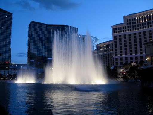
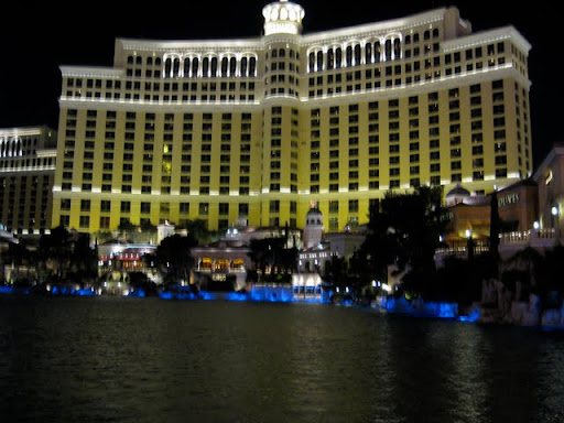
Bellagio Fountain, April 2010

Bellagio Fountain, April 2010

I know I went for the cheap water wonk gag with the Bellagio Fountain thing the other day, but it carries symbolism well beyond the acre feet involved. On the way past the fountain last night after dinner, I could have sworn I saw a couple of ducks in the shadows against the faux Italianate villas, so I went back this evening before dark for a better look. Sure enough, five mallards. They looked completely out of place.

For an alternative take on the Las Vegas water story, I found my way this afternoon to the wetlands along Las Vegas Wash on the east end of town. Clark County’s sewage treatment plant dumps into the wash, which leads down to Lake Mead. It’s an example of a familiar method of western water accounting. Vegas withdraws water from Mead. Some of it  ends up on lawns and gardens and evaporates into the dry desert air. Some of it ends up flushed down to the sewage treatment plant and thence on to Lake Mead. Vegas gets a return credit for that water against its total allotment.

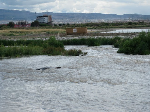
Great blue heron, Las Vegas Wash, April 2010

Great blue heron, Las Vegas Wash, April 2010

As a byproduct of this accounting methodology, you end up with a river running year ’round down Las Vegas Wash, which before human intervention would have only been wet during flash floods. When you add water, nature happens. I saw herons and egrets and an osprey circling overhead, all birds that live around water. They never would have made a place like Las Vegas Wash their home before the advent of modern sewage treatment plants and return flow credits.

An interagency group manages the Las Vegas Wash with facilities intended to improve water quality on its way to Lake Mead, primarily by slowing it down. A series of weirs have created spectacular wetlands, a rare commodity in the desert. Hence the great blue herons. The people doing the project understand the side benefit going on here. They divert some of the water into a wetlands park with a wheelchair-accessible 1.5 miles of walking trails, little ponds and groves of trees and wonderful marsh habitat. They’ve also built trails out to the weirs along the main wash.

It’s gorgeous. The birds were fabulous. I counted 25 species on my walk, 13 of them water birds. Compare that to the five mallards at the Bellagio Fountain.

But is it nature?

Who’s the most desperate for water?

YUMA, ARIZ – On the Lower Colorado River, there are three large municipal water wholesalers behaving with a certain air of desperation in their hunt for long term supplies of water: the Southern Nevada Water Authority (Las Vegas), the Metropolitan Water District (Southern California) and the Central Arizona Project (Phoenix/Tucson). So who wants it bad? Here’s a data point.

YDP outlet canal

YDP outlet canal

West of Yuma, in the crook of the bend where the Colorado River turns south into Mexico sits the Yuma Desalting Plant. Built in the 1980s, the plant’s purpose was to take high-salinity agricultural runoff, clean it up via a reverse osmosis process, and send it on down to Mexico to meet part of the U.S. water delivery obligation. But for a variety of reasons, it was never really used. An early ’90s flood on the Gila River damaged the intakes, but mainly it was never really needed. The 1990s were a time of plenty on the Colorado, and there was enough surplus sloshing around in the system that it didn’t make economic sense to run the plant.

That has changed. At the request of the three water giants – SNWA, MWD and CAP – the U.S. Bureau of Reclamation is preparing to start up the plant for a test run, to gather data on operating costs, the amount of water that can be produced, etc. Starting May 3, water will start running down the empty concrete drain above and into the Colorado. The water will be used to meet a small part of our delivery obligations to Mexico (something around 30,000 acre feet over the course of a year). The agencies that funded the work will get a credit, and a like amount of water will be stored upstream in Lake Mead with their name attached for their future use.

So here’s the data point. MWD is paying 80 percent of the cost. CAP and SNWA are each kicking in 10 percent. That willingness to pay on the part of MWD tells me something about who needs water the most in the near term.

Water in the desert, Las Vegas edition

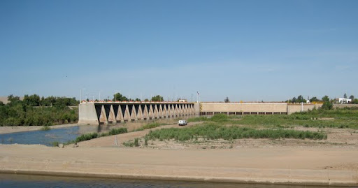
LAS VEGAS, NEV – The distance between Morelos Dam on the lower Colorado and the Bellagio Fountain is profound. Morelos spans the U.S.-Mexico border, with the wheat fields and onions of the Yuma County Water Users Association behind me as I took this picture and Algodones on the far bank. Most years, Morelos is where the Colorado River effectively finishes its now futile run to the sea.

Morelos Dam, April 2010

Morelos Dam, April 2010

You can see a Border Patrol truck in the foreground. They were very attentive to my presence as I drove the levee this morning between Yuma and San Luis, on the U.S. side of the border.

After some more stops to see the Lower Colorado’s plumbing (more pictures later), I made a beeline for Las Vegas. The contrast could not have been more stunning – up through the Sonoran and Mojave deserts, all mesquite and creosote, with occasional glimpses of the river strip in the distance, then through a ridge in the mountains, from quiet desert to this:

Bellagio Fountain

Bellagio Fountain

Apologies for the slightly blurry image, but I just have a little point-and-shoot. It was windy and they called off the show, so it’s really more the Bellagio pond. I’ll try to get back tomorrow. But I just had to go see it.