Visiting the Birds

The Birds, by Irot

Saw the Birds above from the train window yesterday, and went back today on my new ebike for a closer look.

The ebike is primarily an accommodation for my age and failing knee, allowing me to ride more longer when I feel like it – hauling groceries, or books and laptops to work, or searching out distant tacos, that sort of thing. But with its motor and giant everything-proof tires, it also proved a useful workhorse this morning for getting up the railroad tracks in Albuquerque’s near North Valley for a closer look at Irot’s Birds.

Next Steps on the Colorado River

If we have learned anything from the current crisis on the Colorado River, it is that we have to know what we’ll do next if the current thing we’re doing isn’t enough.

That’s a bloggy shorthand for a deep argument that Eric Kuhn, Jack Schmidt, and I made in comments we submitted this week in response to the U.S. Department of Interior’s request for input on the development of new river operating guidelines.

As we begin discussing what replaces the soon-to-expire Colorado River operating guidelines, we argue that there are important lessons to be learned from a careful examination of the way the current guidelines have failed us.

The Failure of the 2007 Guidelines and Drought Contingency Plan(s)

In its Final Environmental Impact Statement in support of the 2007 Interim Guidelines, Interior identified the purpose and need of these Guidelines as an effort to provide “predictability” – “a greater degree of certainty to United States’ Colorado River water users and managers …, thereby allowing water users … to know when, and by how much, water deliveries will be reduced in drought and other low reservoir conditions.”

“Predictability”? “Certainty”? Crisis of 2022 says “nope”.

We’re trying to use language here – “purpose and need”, the National Environmental Policy Act terms of art – that burrows into the heads of the hard-working feds who will be reading it (we wave – you know who you are).

The failure, which Eric, Jack, and I talked about here in an argument developed while we were working on these comments, was a set of operating rules keyed on reservoir elevations in a way that managed to hold them steady, but never refilled them. That left us vulnerable to the crash that we’re now seeing.

Our immodest suggestion

New operating rules must be keyed to the actual flows of the river, not simply the levels of the reservoirs:  “[S]tream flow should be used as a component in triggering different operating regimes, not solely reservoir elevation levels.” This was the great failing of the ’07 guidelines. We need to fix it.

In some sense this seems obvious, because hydrology is now imposing this constraint on us – “long-term average consumptive uses and losses will not exceed the average natural water supply provided by the watershed”.

We recognize that there are multiple devils in the details of this recommendation including the duration of years during which balance is sought and the mechanisms by which reductions in use must be implemented to maintain a balance. Nevertheless, there is no alternative to balancing the system. We estimate that the natural supply for the period 2000-2022, including inflows within Grand Canyon, has been 12.8 maf/yr, and there is no alternative but to at least reduce basinwide water use to that value. Should watershed runoff decline even further, then basin-wide use must be further reduced.

And if or when it gets wetter again?

[I]f relatively wetter periods return, consumptive uses must remain low to recover reservoir storage.

And all of this must be done in a way that recognizes who’s been left out of past discussions like this:

We are fully cognizant of the conflict between full development of currently unused or unquantified Tribal water rights and the need to reduce overall water uses in the Basin. We believe, however, that an appropriate balance of water supplies and uses cannot ignore the unquestioned right of Tribal nations to the water necessary to fulfill the purposes of their reservations.

And this (we wave again – you know who you are):

We recognize that these goals are broad, extending beyond what some in the basin are advocating – a narrow reconsideration of reservoir operations. We are sympathetic to the burden that the breadth of analysis we are advocating will place on the dedicated and hard-working staff at Reclamation and the Department of the Interior during the next years. But anything less than an expansive view of the task at hand will fall far short of what is needed at this moment in history.

There’s lots more in the way of specifics. We encourage those interested in river management to give it a look.

Welcome new readers!

Agricultural heritage?

Welcome new readers!

With the current attention on the Colorado River’s crisis, I’ve had a great many people sign up for my blog feed in recent weeks. I’m so happy to have you join our Inkstain community! But an up front apology may be in order, as this might not be what you expected.

I’m John Fleck, a former journalist turned academic. I spent five years as director of the University of New Mexico Water Resources program, and I’ve recently joined the Utton Center, a natural resources policy group at the University of New Mexico School of Law, as the center’s Writer in Residence.

I’ve written a couple of books about the Colorado River, and at times I use this blog to perform a sort of “post-journalism”, sharing important stuff that I have learned. After 35+ years of daily journalism, it’s a hard habit to break.

I also have active collaborations with a group of friends and colleagues, and the blog is a great place to throw our stuff out into the information sphere when we think it might be of some use.

Ribbons of Green

I had every intention of putting my Colorado River work on simmer in 2022 – still available for snacking, but not the main meal. With my friend and colleague Bob Berrens, I’m hard at work on a new book about Albuquerque and the Rio Grande, a sort of environmental/institutional/literary work on how our community’s relationship with the river shaped both.

We’ve actually signed a contract. We have an actual deadline for the book.

Albuquerque Journal, Oct. 8, 1882

Bob and I teach graduate students in the University of New Mexico’s Water Resources Program and share tidbits like the old newspaper clip to the right, an 1882 real estate advertisement in which a chap named D.B. Emmert (“notary public, real estate and insurance broker”) is selling what seem to be the first explicitly advertised parcels of irrigated suburban land: “Splendid opportunities … for those who want vegetable or fruit gardens or suburban houses”).

The railroad had just arrived in Albuquerque, a moment of profound change that has delightfully weird water policy implications.

We’re fascinated by the cultural evolution of the valley in which we live, as we alternately battled with, and embraced, the Rio Grande, the river that flows through the midst of our town. As a matter of rhetoric and cultural identity, our community celebrates its “agricultural heritage”, but we’ve created more than a century’s distance between those hazy, romantic notions of that heritage and its reality – then and now.

That distance, and those notions, have critical implications for water policy today, which is what dragged Bob and I into this arena. “There’s less water. What do we do?” is the framing question for our students’ journey through the eclectic fall class about to get underway. For the tenth time! This is the tenth fall we’ve taught this class together!

Bodies in Lake Mead

Turns out Casablanca isn’t actually a desert! (I was misinformed.)

Unfortunately for my best-laid plans for 2022 (also, more importantly, for the 40 million people who depend on the Colorado River – my problems don’t amount to a hill of beans here), they’re finding dead bodies in Lake Mead. Because there’s not very much water in it. Which means less water for the people downstream who depend on it, or the people upstream who may or may not bear some responsibility for helping refill it.

This has captured a bit more of my attention this year than I had hoped, which is likely why, dear new readers, many of you have joined our little community. I’m a writer. I can’t help but write about what I’m thinking about. And I’m thinking about the Colorado River.

Sketchbook

This blog has always been my sketchbook – a habit I acquired from my late father, who was an active, productive artist his entire life. His sketchbooks were everpresent in our lives. The twist for me is that, as a lifelong newspaperman, I only know how to write in public. Journaling, diaries, have never worked for me. So when blogging emerged in Internet 1.0 days, I took to it.

I have no editor. There will be typos.

It is my fervent hope, dear new readers, that you’ll read a lot here in coming months about the gardens of early Albuquerque – the crazy early 20th century lawn irrigation patents and swamps-turned-tobacco farms-turned-boutique alfalfa stands.

It is my clear-eyed expectation that you’ll see a lot of my agonized musings about the dark, dead-bodies-in-Lake Mead trajectory of my beloved Colorado River.

It is my promise that, broken-down knee notwithstanding, you’ll still get a healthy dose of bike riding essays. (I just invested in an e-bike! My bad knee celebrates!)

Welcome!


Nevada: lack of a deal threatens the future of the Colorado River

Strongly worded letter today from John Entsminger of the Southern Nevada Water Authority about the failure to reach a deal on Colorado River cutbacks:


More later, I’m supposed to be paying attention to a zoom meeting, but making this as broadly publicly available as possible seemed important. Click the “view document” link to see the whole thing.

How We Got Into This Mess on the Colorado River

By Jack Schmidt, John Fleck, and Eric Kuhn

On the eve of the release of the US Bureau of Reclamation’s August Colorado River reservoir forecasts – freighted with meaning this month because of Reclamation’s ultimatum to the states about the need to cut water use – we look back at the last four decades of water-supply management to pose the central question:

How did we get into this mess? Our answer in brief:

When the Colorado’s flow was up, we used it all.

When it was down, we drained the reservoirs.

The river’s natural flows have been down for a long time.

And during the few stretches of somewhat higher flows, we did not significantly refill the reservoirs.


A failure to set water aside for the future

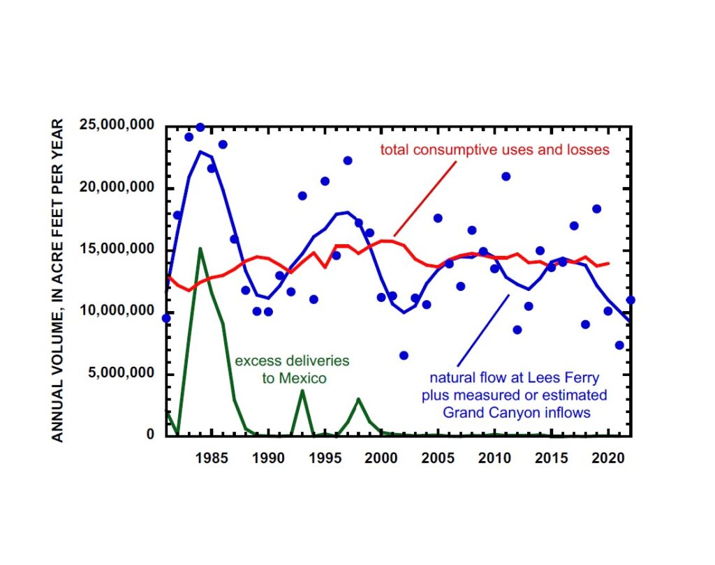
Colorado River water use outpacing supply. Graph by Jack Schmidt, Utah State University

Operating year to year, it is easy to get lost in the river’s annual ups and downs, and the immediate desire to get water to farm fields and cities – THIS YEAR! NOW!

But the longer view, based on the best available data, makes clear our mistakes during the past 20 years. Since the year 2000, the blue line in the graph above has spent little or no time above the red line. That is water use outpacing supply.

The result – the most recent three consecutive dry years have left us with headline-clear problems:

  • Reservoir storage is 66 percent less than it was in 2000.
  • Reclamation is concerned about the structural integrity of the river outlets at Glen Canyon Dam that will be continuously needed if Lake Powell falls below the minimum power pool elevation.
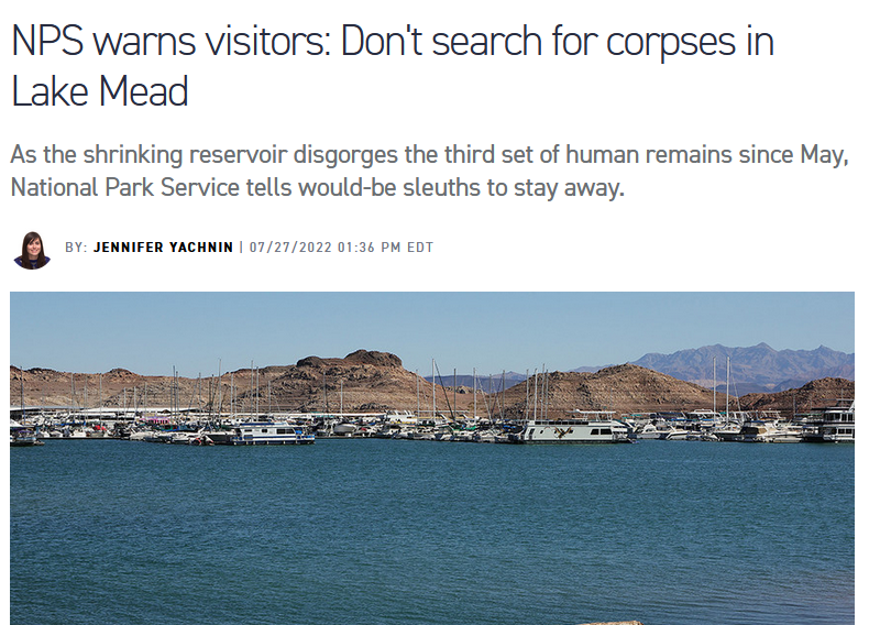
  • Las Vegas’s old water supply intakes – and dead bodies! – are emerging from the Lake Mead mud.

21st century Colorado River water use has exceeded supply by 1.2 million acre feet per year

The graph’s nuances are worth noting.

Blue dots represent each year’s total natural water supply – the sum of the natural water yield of the entire Upper Basin and of the many springs and tributaries that flow into the Colorado River in the Grand Canyon. This natural supply, not considering the Gila, Bill Williams, or Virgin Rivers, averaged 12.8 maf/yr (million acre feet per year) in the 21st century, 23% less than the average between 1981 and 1999.

To help visualize longer-term trends and cycles, we statistically smoothed the data to create the blue line, which more clearly shows the longer-term ups and downs of the Colorado River’s flow. The smooth line makes clear the wet periods of the 1980s and 1990s, and the deep droughts of the early 2000s and of today. Importantly for our current mess – the “wets” of the 21st century were not as wet, and the “drys” were drier, than those of the late 20th century.

The red line – total basin water use and reservoir evaporation loss (not including uses and losses in the Gila, Bill Williams, Virgin, or Little Colorado watersheds)  – crept up through 2000 as the Central Arizona Project finally grew into the paper water allocations of the 20th century Law of the River.

Total consumptive uses and losses, including treaty deliveries to Mexico, peaked in 2000 at ~15.8 maf and were reduced during the next 2 years. Thereafter, average basin-wide consumptive uses and losses remained ~14.2 maf/yr between 2003 and 2020, and individual years were consistently within 4% of the average of that period. Throughout the 21st century, total Upper Basin uses and losses were ~30% of the basin-wide total.

Sustained consumptive uses and losses that exceed the natural supply can only be sustained by draining the reservoirs – but only so long as there is available water in the reservoirs. Thus, it is no surprise that the 21-year average (2000-2020) rate of water consumption and losses that exceeded the natural supply by ~1.2 maf/yr led to today’s crisis.

There were a few opportunities to rebuild reservoir storage, especially in 2005, 2008, 2009, 2011, 2017, and 2019, but a decades’ long water consumption rate that exceeds natural supply is unsustainable. The reservoirs are now mostly drained.

The failure to refill

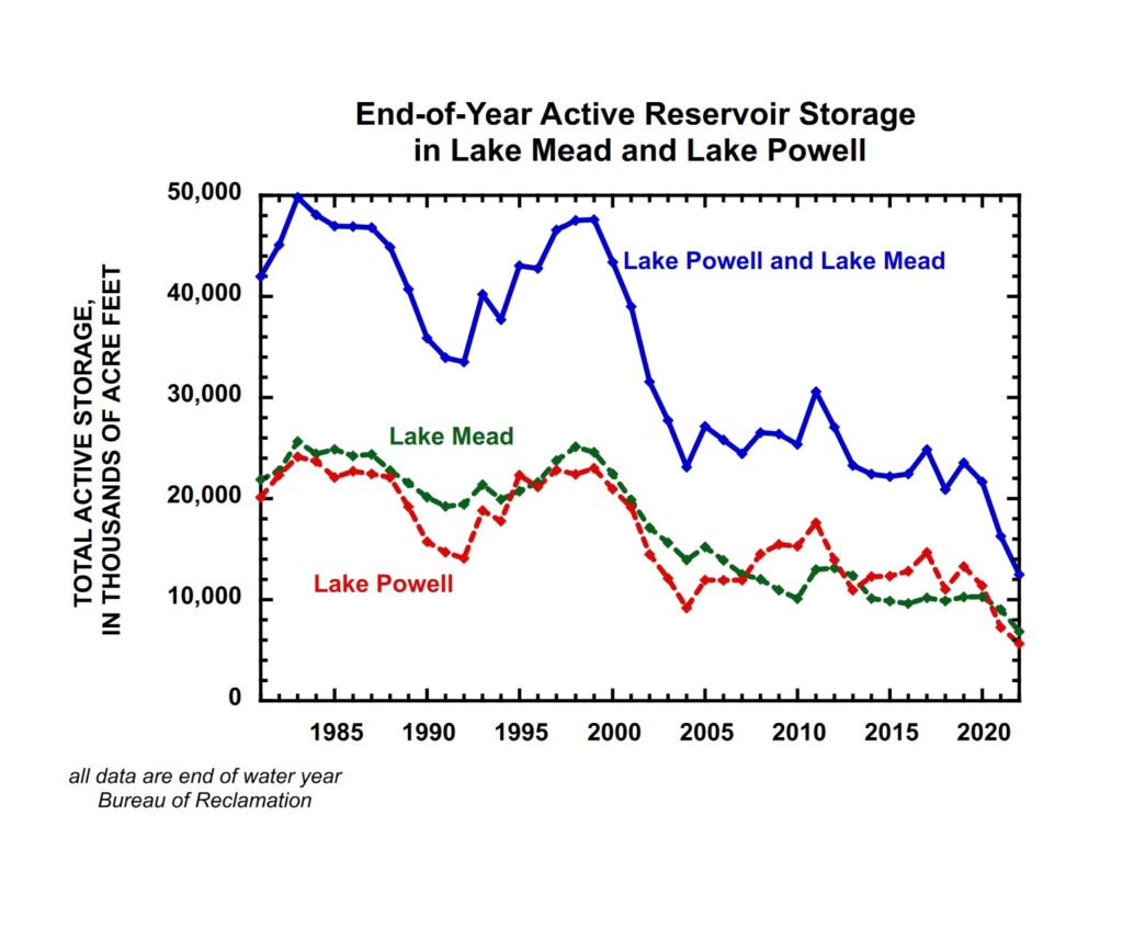
The reservoirs’ decline. Graph by Jack Schmidt, Utah State University

The history of water storage, described in the two graphs, has gone like this:

  • The reservoirs were brim full in the mid-1980s and lots of water passed through the delta to the Gulf of California
  • Reservoirs were somewhat depleted in the late 1980s and early 1990s when basin-wide consumption exceeded natural supply, but the reservoirs refilled in the late 1990s due to three years when supply greatly exceeded consumption (1993, 1995, and 1997). Thus, the reservoirs were relatively full in 2000 when the Millennium Drought began.
  • Reservoir storage greatly decreased thereafter when the natural supply was never greater than 11.7 maf/yr (2001) and was as low as 6.39 maf/yr (2002).
  • Reservoir storage stabilized at a new lower level thereafter when there were a few wetter years between 2006 and 2011. The last relatively wet year was 2019, but our continued use of large quantities of water was such that this sequence of somewhat wetter years was not used to rebuild reservoir storage.
  • Natural supply has been especially low between 2020 to 2022, averaging 9.4 maf/yr, which is far less than the basin-wide consumptive uses and losses that are approximately 14 maf/yr (we note that basin-wide consumptive use data are not available for 2021.)

Thus, today’s crisis – two decades of low natural supply, including some short, very dry periods, cannot sustain consumption and losses that exceed the natural supply and that have not significantly changed since 2003.

Policy Implications

What are the policy implications of this analysis?

  • There has been a natural cyclicity of somewhat wetter and somewhat drier years, but the recent wet periods, when the reservoirs might have been refilled, have not been as wet as in the 1980s and 1990s.
  • The recent dry period that we are experiencing today since 2020 is comparable to the dry period of 2000-2005.
  • Reductions in consumptive water use and losses mandated by Commissioner Touton will need to remain in place through the end of the present very dry cycle and well into any future wetter cycle in order to rebuild reservoir storage.
  • The call for an immediate reduction of 2-4 maf/yr in consumptive uses and losses is an unprecedented reduction in relation to the pattern of use in the watershed since 2003.
  • Anything less than sustained reductions of the scale demanded by Touton’s ultimatum risks crashing the system – certainly if we get another year or two of very low runoff from the Rocky Mountains.

An explanation of our methodology

The present water-supply crisis is a simple mass balance problem and we sought to describe this mass balance in the simplest way – averaging for the entire watershed

How did we consider inflows?

  • We used Reclamation’s estimates of natural flow at Lees Ferry, including the provisional data that are available for 2022. We used ~40 years of data.
  • We estimated inflows downstream from Lees Ferry that flow into Lake Mead based on the difference between USGS measurements made at Lees Ferry at the upstream end of the Grand Canyon and near Peach Springs, just upstream from Diamond Creek at the downstream end of the Grand Canyon. These data are available for 1990-2021, and we used the average for the 1990s as the estimated inflows of the 1980s. We used the average for the 2010s as the inflow in 2022. These data include inflows from the Paria and Little Colorado Rivers.
  • We added these two data sets as the available natural supply available for water users. We did not consider the natural inflow of the Virgin, Bill Williams, or Gila River because these rivers, with only rare exceptions like year 2005, are fully depleted and considered the sole domain for use by the Lower Basin states. Note that 2001-2005, Lower Basin use of these three tributaries was 2.2 maf/yr (the last years for which these data are available).

How did we estimate consumptive uses and losses?

  • We used Reclamation’s Consumptive Uses and Losses reports and Water Accounting reports
    • For the Upper Basin, we used revised and peer reviewed data prior to 1995 and provisional data 1996 to 2020. Data for 2021 are not available.
    • For the Lower Basin, we used Colorado River system summaries prior to 2005.
    • For the Lower Basin, we used Water Accounting reports 2006-2021.
    • We assumed that Lower Basin mainstem reservoir evaporation 2006-present was same as the average for 2001-2005 (1.1 maf/yr).
    • We only considered Treaty deliveries to Mexico as a use, and large surplus flows of the 1980s and 1990s were assumed to have passed to the sea.

We assumed that the uncertainty of all values was 2 or 3 significant digits and rounded off our calculations accordingly.

the authors

  • Jack Schmidt is Janet Quinney Lawson Chair in Colorado River Studies, Center for Colorado River Studies, Watershed Sciences Department, Utah State University
  • John Fleck is Writer in Residence at the Utton Transboundary Resources Center, University of New Mexico School of Law; Professor of Practice in Water Policy and Governance in UNM’s Department of Economics; and former director of UNM’s Water Resources Program.
  • Eric Kuhn is retired general manager of the Colorado River Water Conservation District based in Glenwood Springs, Colorado, and spent 37 years on the Engineering Committee of the Upper Colorado River Commission. Kuhn is the co-author, with Fleck, of the book Science Be Dammed: How Ignoring Inconvenient Science Drained the Colorado River.

At this point, a voluntary “2 to 4 million acre feet of additional conservation” Colorado River deal by Aug. 16 seems out of reach

Janet Wilson had a helpful story yesterday in the Desert Sun about California’s negotiations over its piece of the looming Colorado River cutbacks. Its bottom line is that California – the state with the largest Colorado River allocation – is talking about kicking in 500,000 acre feet of water. Or maybe it’s really just 400,000 acre feet of water – as the Metropolitan Water District of Southern California’s Bill Hasencamp told her, paraphrased, the negotiations are fluid and numbers could change.

A reminder of what Reclamation Commissioner Camille Touton told senators just seven weeks ago:

In the Colorado River Basin more conservation and demand management are needed in addition to the actions already underway. Between 2 and 4 million acre feet of additional conservation is needed just to protect critical elevations in 2023. (emphasis added)

4 million acre feet is obviously out of reach. It always was.

But if Wilson’s numbers about California’s contributions are right – and she’s a good reporter, we have every reason to believe they’re in the ballpark – 2 million acre feet of additional conservation is beyond the grasp of a voluntary deal as well.

The arithmetic is straightforward.

The Upper Basin has said “not our problem“.

Nevada’s share of the river is so tiny that its contribution is couch cushion change, a rounding error.

That leaves, in round numbers, 1.5 million acre feet of water to come out of Arizona just to get to Touton’s bottom line number for additional conservation. That would require completely drying up the Central Arizona Project canal. (CAP is taking 1.031maf this year, and averaged ~1.4maf over the previous fives years). I’m frequently surprised by Arizona, but it seems unlikely that they’ll agree to a voluntary deal that dries up the CAP canal. If that’s where we end up, Arizona’s best alternative to a negotiated agreement will be to just make the feds do it, make them take the heat. (Worth noting that FiveThirtyEight has Arizona Democrat Mark Kelly slightly favored to hold his seat. Water politics is high stakes politics.)

Combine that with the reality that Arizona’s Native American communities, major water rights holders, have complained that they’ve been cut out of this entire process, according to a July 22 letter just surfaced.

I can imagine creative accounting that might allow everyone to grin through their teeth and count water moved down to Lake Powell from Flaming Gorge and other Upper Basin reservoirs as part of the 2 million. That’s pretty clearly not what Touton called for in June. It’s not “additional conservation”. But it might create some space for a face-saving deal.

Whether that would be enough to protect us from dead pool is another question.

A reminder of the stakes

The Bureau of Reclamation’s most recent “minimum probable” model runs show Lake Powell dropping below power pool – unable to generate electricity, and forced to move water through bypass tubes that Reclamation has made clear it does not trust – by October 2023.

Under that same scenario, Lake Mead drops to elevation 992 feet above sea level over the next 24 months.

(Trust me, having to type a Lake Mead elevation level without having to use a comma made me clench.)

At that point, a lack of water will make massive cuts a self-executing reality. We’ve drained our buffer. You can’t use water that doesn’t exist.


Tribal sovereigns complain of being left out of Colorado River negotiations

In a July 22 letter, the leaders of 14 Colorado River Basin Tribal governments complained to the U.S. Department of Interior about being left out – again – of the current negotiations around short terms Colorado River cutbacks:


Click through to see the full letter.

“Drouth had no terrors here.”

In drought, we pump groundwater. Albuquerque’s Rio Grande Valley, summer 2021

I dropped off the Santa Fe Overland at Albuquerque about a year ago during the drouth that prevailed over the southwest at that time. The range was as dry and hard as a table. Rivers and streams had dried up. Cattle were dying and the country seemed utterly desolate.

Imagine my astonishment and delight when I visited this thirty-acre truck garden to find trees, flowers, grasses and the entire range of vegetables growing in the most luxurious and prolific way. It was like an oasis in the desert. Everywhere stretched the rows of beautiful green, demonstrating the resurrection power of irrigation.

Drouth had no terrors here. This grower laughed at her threats and called her bluff. Even a dried up river did not taunt him, for he simply tapped the underflow near the surface and was pumping at low cost an immense stream of water.

– Albuquerque Journal, Oct. 30, 1905, quoting an unnamed author writing in the monthly magazine “The Earth” describing their visit to Blueher’s Gardens in Albuquerque’s Old Town

I thought a lot about this passage, which my book coauthor Bob Berrens found in an old Albuquerque Journal, on my Sunday bike ride through the Albuquerque reach of the Rio Grande Valley.

While the Rio Grande itself, the part between the levees, is drying, the trend Herman Blueher and the other Old Town market gardeners started in the 1890s – using wells to keep parts of the valley floor green even as the river dries – has become a dominant way of life in the Rio Grande Valley.

Between the levees, the river in 2022 has begun drying in the Albuquerque reach for the first time in four decades, as we grind through the summer of our third consecutive terrible spring runoff. By one measure I’ve been using, this is the worst three-year stretch here since the drought of the 1950s.

It’s a complicated mix right now of hydrology and management decisions. While the river channel itself, the part between the levees, dwindles, flows of water in the irrigation ditches through town are actually up a bit. This almost certainly won’t last. The Middle Rio Grande Conservancy district has burned through the last of its imported San Juan-Chama Project water, and the only water left in storage is a bucket set aside to ensure the valley’s Native American Pueblos, with their senior water rights, can continue irrigating.

But get off the river into the communities that surround it, and you’ll barely notice the drought.

After riding out onto the Alameda bridge yesterday to gape in dark fascination at the dwindling river, my mental health management ally Scot (bike rides, amiright?) and I ducked into what I think is called the Rio Grande Estates subdivision, a little cluster of homes built in the 1980s off of Rio Grande Boulevard in the far North Valley.

Last year around this time, as the river limped, a bike ride through Rio Grande Estates was an “aha” moment for me.

On the ride: lawns, green, sprinklers spraying into the street (see picture above from that fateful day).

Home with the maps: what, what? All those homes have their own shallow wells!

When Johnson Drilling put in wells in the summer of 1988, they found a good, productive aquifer layer of gravels at about 30 feet down. The entrance to the neighborhood here is about a quarter mile from the river – the part where water usually flows on the surface. The interconnections between surface and underground water is such that the gravel layer Johnson hit is basically a part of the river – the “underflow”, as our 1905 correspondent put it.

“Drouth had no terrors here.”

What Bob and I call the “Ribbons of Green” in the new book very intentionally includes this. Our ribbons extend far beyond the boundaries of “river” set by the levees, because this is all part of the river too – the tree-lined ditchbanks, the lush lawns of these valley homes. We’ve pinned the river itself between narrow levees and then manually spread its dwindling water ourselves – with diversion dams and ditches, or with our groundwater wells – across the river’s old flood plain.

If you’re irrigating off of a ditch, this year is about to get a lot tougher. If you’ve got a well – for your lawn, or your pasture, or your farm – you’ll be OK this year. How long that can continue is an open question, very locally situational.

I’m off for the next couple of days to a state legislative committee hearing where folks will be discussing a bunch of relevant questions about what we do next:

  • How do we ensure that our indigenous communities’ rights to water are respected as supplies shrink under climate change?
  • What are the long run implications of our increasing use of groundwater to fend off “drouth”?
  • What of the environmental flows in the river itself, the part between the levees?
  • How can we protect the communities of the Middle Rio Grande Valley’s water supplies while also meeting our legal obligations to deliver water downstream?

If these questions had easy answers, we’d have already finished the quiz and handed it in to the proctor. This is hard stuff.