the ditches are running

I took a detour from the bike trail this morning to see water in the Albuquerque Main Canal, which brings irrigation water to Albuquerque’s strangely urbanized rural valley. There are 350 miles of canals threaded through the Middle Rio Grande Conservancy District’s Albuquerque Division, bringing water to something like 10,000 acres of land.

Albuquerque’s ditches are beginning to run

It was near the spot where the late Joe Trujillo, who oversaw this part of the irrigation network for the District, once described for me the joy of turning on the ditches every March. You can see the valley breathe in, he told me. “Running water,” he told me. “My favorite time of year.”

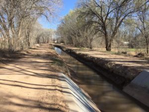
The nice modern concrete apron in the picture to the right funnels the water into a siphon that carries the canal beneath a six-lane highway. But the old dirt ditch to the north is more typical of irrigation here. The District diverts water from the Rio Grande at Angostura, 15 or 20 miles to the north, moving it through a complex network of canals that spiderweb the valley floor. It is a complicated system:

Most of the canals in the Division are directly descended from Acequias founded during Spanish rule in the 17th and 18th centuries.  Plot size is generally small and there are literally thousands of turnouts served by many community ditches.  Urbanization has further complicated the delivery system, with many ditches disappearing into pipe, reappearing, disappearing again, etc.  Urbanization has also resulted in already small plots being further divided, and a preponderance of casual irrigators watering lawns, garden plots, etc.

They started diverting at Angostura March 1, and they’re moving 33 cubic feet per second into the irrigation system today.

Old water has its ghosts. Driving a ditch bank one spring a few years back, Trujillo pointed out a meandering line of trees spilling off to the west through a modern neighborhood, explaining that they traced the outlines of an old irrigation ditch.

I’m poking around the edges of a new project, still somewhat ill defined, but as I was leaving the house this morning for a bike ride, Lissa said, “Be sure to work on your new book!” I took her advice.

Depending on who I’m talking to, I describe it variously:

  • the future of farming in the arid Southwest
  • a consideration of these agricultural landscapes as nature
    • what do we mean by “nature”?
  • a dive into the exogenous forces that shape this landscape
    • a change in Saudi groundwater pumping policy nudges the global market for hay
    • the price of corn!
    • the 1902 Newlands Reclamation Act

That last bullet is the most interesting to me right now, but the hardest to describe and the most difficult to “storyize”. I’ve been talking to farmers about how they decide which crops to plant. One, a friend who grows melons, told me to keep my eye on the price of corn, explaining that its rise and fall cascades through U.S. agriculture, affecting pretty much everything else.

According to the USDA, U.S. corn acreage this year is forecast to be down 4.5 million acres, to 90 million acres. I’m still not sure what to make of the implications, but I’m slowly getting a feel for it. I’m not sure what form compelling journalism about the price of corn might take, what that looks like. But these things take time. I learned writing Water is for Fighting Over that the book will almost certainly look and feel very different at the end than it does now, so I’m trying to be intellectually patient.

Down in Albuquerque’s valley the water’s flowing, and things are greening up. Pollen and allergies notwithstanding, it was a nice more for a ride.


Linking Forests to Faucets

New work by UNM colleagues (Dadhi Adhikari and others) suggests municipal water users are willing to pay for work to improve the health of the watersheds that supply the city’s water – in this case Albuquerque:

Econometric results show evidence of … significant public support for forest restoration – linking forests to faucets.

(Dadhi is a UNM economics grad student, the other three authors are UNM econ faculty, all affiliated with the UNM Water Resources Program.)

To fix Oroville, they shut down a river. Then built a road.

This Bee aerial video of the work on the Feather River to try to cope with the problems at Oroville Dam is an amazing illustration of the scale of human intervention in rivers:

Oroville, screen grab from Sacramento/Fresno Bee

Click through for the full video, no one screen grab can do it justice. They’ve completely shut down the spillway so they can get in and clear the debris plug that is preventing the power plant from operating. This is primarily about the use of the power plant to remove water from the reservoir, not the power.

A nice storage bump for Colorado River reservoirs, but they’re still pretty empty

Talking this week to members of the Colorado River water governance brain trust at the Family Farm Alliance‘s annual gathering in Las Vegas, there was a weird vibe about the big snowpack building in the Rockies.

forecast storage Sept. 30, 2017

My quick take based on the February USBR modeling plus the latest forecast info from the CBRFC Lake Powell could pick up 4 million acre feet this year, and with a likely release of some bonus water through the Grand Canyon for downstream users, Lake Mead could stabilize.

These numbers have substantially reduced the pressure to finalize a “Drought Contingency Plan” to reduce use of Lake Mead water in the Lower Basin and prepare for possible Powell shortfalls in the Upper Basin. All that extra water and breathing room must be a good thing, right? The weird thing was the tenor of some of the resulting conversations. The DCP deal is important, and it was really close. Now, to some folks, it’s looking less urgent. With the pressure reduced, some of the key players seem to be using the opportunity to drive harder bargains (or dig their heels in to avoid hard bargaining) – on the complex shortage distributions within Arizona, for example, and on the Salton Sea.

For those trying to get the damn deal done, the big snowpack is a setback.

So it’s worth reminding ourselves where we’re at. From the perspective of the last few years, a 4 million acre feet bump is great news. But as the graph above makes clear, we’ll still end up the water year down 20 million acre feet from the start of the 21st century. We’re along way from being out of the hole.

Henry Mancini and the fountain at the Bellagio Hotel

Bellagio fountain, February 2017

Some years ago, on one of my first reporting trips to Las Vegas for my book, a friend who introduced me to the fountain in front of the Bellagio Hotel suggested a bit of economics that lingered. He pointed up to the big hotel and ventured a guess at the revenue flowing through it – a rough billion dollars a year.

His idle comment turned into this fun bit of business in my book Water is For Fighting Over: and Other Myths About Water in the West:

The Bellagio’s fountain, often mocked as a symbol of water excess in the arid Southwest, may in fact represent some of the highest-value water around. The 12 million gallons a year needed to keep it topped up starts as water too salty to drink, drawn from an old well that once irrigated the Dunes Hotel golf course. Twelve million gallons sounds like a lot, but it’s really just enough to irrigate eight acres of alfalfa in the Imperial Valley. Total revenue at the seven giant casino–resort hotels contiguous to the fountain, at the corner of Flamingo Road and South Las Vegas Boulevard—the heart of the famed Las Vegas Strip—is an estimated $3.6 billion…. Given the crowds lining the sidewalks for each one of the fountain’s dancing-water shows, the fountains must represent one of the most economically productive uses of water you’ll find in the West.

I’m in Las Vegas this week the annual meeting of the Family Farm Alliance, an ag irrigation NGO. (Fascinating meeting, interesting people.) After the sessions ended, I wandered up the strip to hunt for dinner and ended up, as I often do, at the Bellagio fountain. The Friday evening crowd was swelling, and the 6 p.m. fountain show’s music was Henry Mancini’s Pink Panther Theme.

Peak Vegas.

From Reno, a data point illustrating how epically wet the winter of 2016-17 has been in the West

In Reno, a record year seven-plus months early

This is “water year” precipitation in Reno, Nevada, from Oct. 1 to Sept. 30. The brown line is an average years’ accumulation. The pinky-purple line is 1982-83, the all time wettest year on record, going back to the 1890s. The green line is this year.

Folks, 2017 has already eclipsed Reno’s wettest year on record  with more than seven months to go.

the real risks on the Colorado River – a lack of appropriate rules

We’re devoting a lot of attention in the Colorado River Basin to preventing “shortage”, which will happen if Lake Mead enters any given year below elevation 1,075. The discussions are around a new “Drought Contingency Plan” that would reduce water use in the basin, heading off the risk of 1,075 (now at a one in three chance for 2018, though that calculation was done before the latest round of Upper Basin snow).

Deputy Interior Secretary Mike Connor at the San Luis Bridge, March 28, 2014, watching the delta pulse flow

But the real risk is not 1,075, it’s really 1,025. Under the current operating rules, we could drop from 1,075 to 1,025 in a hurry, and at that point we’d be very close to a system crash in which lots of people don’t get water. As former Deputy Secretary of the Interior Mike Connor pointed out in a 2014 interview with me, the real risk is when Lake Mead drops to levels so low that the risk of catastrophic shortages is high and we lack the rules to deal with it. Here’s the scene from my book:

As we turned from the river to ferry Connor back to the Yuma airport for his flight home, the talk turned to the serious next steps. At that time, the Bureau of Reclamation’s internal modeling efforts showed the potential for drought and climate-change trouble ahead. As Lake Mead drops, rules kick in that require water users in Nevada, Arizona, and Mexico to remove less water from the system each year. But those reductions are modest, and Connor told me that the Bureau’s worst-case modeling showed that even with the agreed-upon reductions, Lake Mead could quickly drop past a point of no return, to levels at which the current rules would be no help in determining who was entitled to how much.

Connor, who since leaving Interior at the end of the Obama administration has been named a Walton Family Foundation Environment Program Fellow, explained it this way in an interview published last week:

People will start to get nervous because there is not a plan in place on how to manage water allocation in the lower Colorado River if Lake Mead drops to critically low levels below 1,025 feet. The potential for a very sharp decline in lake levels will unsettle everyone.

The thing is, the near term actions being taken in the Drought Contingency Plan to reduce the risk of a 1,075 shortage will also help establish a framework to manage much lower levels, by reducing water use by all the states of the Lower Basin.

A good snowpack in the Rockies has reduced the risk. But it has not gone away.

Climate change is already sapping the Colorado River

High temperatures mean less water on the Colorado River

A warming climate is already reducing the flow in the Colorado River, and the future risk is large, with a worst case of the river’s flow being cut in half by the end of the century, according to a new study from a pair of the region’s leading researchers. While precipitation declines since the turn of the century have been modest, Brad Udall and Jonathan Overpeck found, a little less rain and snow have translated to a lot less water in the river:

Between 2000 and 2014, annual Colorado River flows averaged 19% below the 1906-1999 average, the worst 15-year drought on record. At least one-sixth to one-half (average at one- third) of this loss is due to unprecedented temperatures (0.9°C above the 1906-99 average), confirming model-based analysis that continued warming will likely further reduce flows.

Their analysis suggests substantial risk going forward:

Recently published estimates of Colorado River flow sensitivity to temperature combined with a large number of recent climate model-based temperature projections indicate that continued business-as-usual warming will drive temperature-induced declines in river flow, conservatively -20% by mid-century and -35% by end–century, with support for losses exceeding -30% at mid-century and -55% at end-century.

While we have seen projections of the future impact of climate change on the Colorado for more than two decades, this study is important because it is one of the first to argue empirically that the change is already underway. (See also Woodhouse and colleagues last year, which I wrote about here.)

Key to the new paper’s argument is a comparison between the previous worst 15-year drought on the Colorado River, from 1953-1967, and the current one. As measured by precipitation, the ’50s were a lot drier than now. But the current drought, which began in 2000, is a lot drier in terms of river flow. The difference? It’s a lot warmer now than it was back then.

Such temperature-driven droughts have been termed ‘global-change type droughts’ and ‘hot drought’, with higher temperatures turning what would have been modest droughts into severe ones, and also increasing the odds of drought in any given year or period of years [Breshears et al., 2005; Overpeck, 2013]. Higher temperatures increase atmospheric moisture demand, evaporation from water bodies and soil, sublimation from snow, evapotranspiration (ET) from plants, and also increase the length of the growing season during which ET occurs.

The results are not a surprise. It seems like at every Colorado River conference I’ve attended over the last few years, either Overpeck or Udall have been on the agenda presenting preliminary “work in progress” results on this. Beyond the stark data, they’ve been making two points. The first is the need for much more serious adaptation measures to cope with the reality of having less water.

This means using less water.

The second, and more important point for the two researchers, has been the imperative to reduce greenhouse gas emissions to protect the future of the southwest’s Colorado River-using communities:

The only way to curb substantial risk of long term mean declines in Colorado River flow is thus to work towards aggressive reductions in the emissions of greenhouse gases into the atmosphere.