
The 1928 report they call “Burkholder’s Bible” – more formally “A Plan For Flood Control, Drainage and Irrigation of the Middle Rio Grande Conservancy Project” – must be treated as one of modern Albuquerque’s founding texts. Like any such text, it rewards careful reading. Also in the manner of such texts, the more you read it, the more confounding it becomes.
Burkholder’s bible
For the new book Bob Berrens and I are beginning to sketch out, we’ve been mucking our way through the question of what they were thinking back in 1928 as Albuquerque, on the brink of its charge into 20th century modernity, wrestled with the Rio Grande.
Human communities had lived comfortably with this river from “time immemorial” in the valley we now call Albuquerque – the indigenous communities tagged with the Spanish name “Pueblo”, then those self-same Spanish. Both built their villages on the high spots – near the river, but high enough to be relatively safer when the river spread across the valley floor during big spring runoffs.
As rivers do, the Rio Grande moved around. In our valley, it tended to pop back and forth between its current channel home and a corridor we now describe by its street names – “North Second, North Fourth”. In an earlier time it bore a more descriptive name – “the yazoo”. When the Rio Grande flooded in modern or near-modern times, it would temporarily reclaim the yazoo.
The early residents, the Pueblo and Spanish colonizers, used the river’s water to grow food – not a lot of it, but enough to mostly get by. To the extent agriculture was a commercially viable enterprise in our valley in the time before, it was sheep grazing in the uplands to the east and west – meat and wool. As a city grew, in the pre-refrigeration era dairies sprang up around Albuquerque’s edges.
But in Burkholder’s 1928, two inexorable forces were converging on the valley. The first was anglo-American modernity, which had started (as often did) with the arrival of a railroad, in our case the Atchison, Topeka, and Santa Fe in the 1880s. The railroad brought wage jobs and immigrants and population growth, and the homes began spilling off the high spots. You can probably see what comes next – the water.
As the human population was changing, so was the river. Perhaps because of increased sediment resulting from overgrazing, perhaps because of reduced flows because of farming upriver in the San Luis Valley of Colorado, the river’s bed was rising. With it rose the water table, and once-farmable land in the lowlands adjacent to the river became waterlogged.
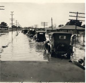
North Fourth, Albuquerque, as the Rio Grande temporarily reclaims its old yazoo during the great flood year of 1929.
By the mid-1920s, surveyors reported more than half of the valley floor in the Albuquerque reach was waterlogged – water within two feet of the surface. They classified 16 percent of the valley’s floor as Some maps from the era we’ve been studying are pocked with amoeba-like outlines labeled “lake” cutting across old farm properties. “The need for drainage in the Middle Rio Grande,” Burkholder wrote, “is so self evident and so well known that little need be said in regard to.” Perhaps, but this did not slow Burkholder’s enthusiasm for the task, as his Plan laid out the elaborate scheme of a network of drains – low channels to carry off the groundwater – across the valley’s floor.
Without drainage this area will decrease year by year until the middle Rio Grande valley will become a vast swamp and the population will be forced to seek homes elsewhere.
Joseph Burkholder is an amazing character. A product of what historians call “the progressive era”, when science would be used by an elite to bring us a boundless future (see Samuel Hayes’ Conservation and the Gospel of Efficiency).
Burkholder was part of that elite. As General Superintendent of Construction and Assistant General Manager of the Metropolitan Water District of Southern California, he oversaw construction of Met’s Colorado River Aqueduct. He went on to serve as General Manager of the San Diego County Water Authority, where he went on to serve as one of San Diego’s first representatives on the Met board.
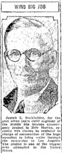
Albuquerque Journal, Feb. 6, 1933
But before all that, his first big project was here on central New Mexico’s Rio Grande, where he was chief engineer overseeing the creation of the Middle Rio Grande Conservancy District.
Today most Albuquerque discussion and discourse around the Conservancy District is about agricultural irrigation, something that did have a crucial place in Burkholder’s plan. “Urban values are dependent, to a great extent, upon the agricultural interests of the surrounding country,” Burkholder wrote. It was a moment of transition from being an agricultural nation to being an urban one, and it was hard for the progressives at that moment to see the unlinking of those two things that would follow. Cities, in their thinking, would be surrounded by farms.
This is the hard part of parsing Burkholder’s Bible. How clearly did he and his colleagues understand that they were building the foundations of an urban valley? Could they have foreseen the railroad bringing us all our food, and the falling away of commercial agriculture in the valley? Was drainage really to save waterlogged farm lands, or to pave the way for the tracts of homes that would soon pop up on the valley floor?
We treat drainage and flood control as solved problems today and don’t think about them much – “dogs that don’t bark”, to borrow from the great water policy thinker Sherlock Holmes. (The lack of a dog barking was the key to solving the mystery of the missing racehorse Silver Blaze. Holmes bids us pay attention to the dogs not barking.) Within a few years of the construction of Burkholder’s drains, the dogs of waterlogging barked no more. Flood control took longer – setting out the draglines to dig the valleys drains was easier than the dams and levees need to reduce what hey called then “the flood menace”. More things were broken in the process, some irreparably, most especially the historic Pueblo community of Cochiti.
But a quarter million people now live on that valley floor, and they don’t hear the bark of those dogs.
You can find copies of Burkholder’s Bible here.
I guess I am becoming one of the ancient ones. Still alive to remember old Albuquerque. I first arrived in Albuquerque in 1948 when the first building west of Tijeras Pass was the Trading Post on U.S. 66 (now East Central) The next buildings were in the Ridgecrest Addition then the University area. TIguez Park was a vacant field that belonged to Blueher Lumber. The Museum was and old Navajo Truck Terminal and then an ABF Terminal. The buildings south of Tiguez were primarily for farm labor. Now the are Airbnb’s . North of Mountain Road was a vast agricultural area including Dietz Farms. The 1929 flood was only one of many recorded floods. My home was built on Blueher Land and an irrigation lateral formed my north property boundary. It was essentially abandoned in 1946 and my backyard boundary now has an adobe wall that runs down the centerline of that lateral.
The flood of 1929 completely destroyed village of San Marcial and damaged Socorro. Photographs of flooded San Marcial. Flood waters took months to recede. The San Marcial Fred Harvey House was flooded and staff took refuge on roof. The depth of water at San Marcial was at least two feet deep. San Marcial’s population was about 2,500 people at the time of the flood. AT&SF relocated 500 people and closed operations in San Marcial. Most of the buildings in San Marcial were of adobe construction. Water from the flood wicked into the walls, and the weight of the roof of the buildings collapsed the buildings.
“In 1929, floodwater roared down the Rio Grande. Much of Polvadera and the eastern portion of Chamisal were damaged. Thousands of acres of farmland were destroyed and covered in silt. Much of Polvadera’s “old town” was destroyed. People rebuilt their homes and farms farther away from the river, nearer to U.S. 85. The San Acacia dam was built to ensure such devastating flooding would not occur again.”
But who remembers that in 1879 the Rio Grand was absolutely dry for 6 weeks.
In the flood of 1936 “ another major flood inundated San Acacia, Polvadera, and down river to San Marcial. When flood waters receded, once again, thousands of acres of farmland lay in ruin.”
“The lake that appeared from Polvadera to Escondida eventually drained. Today’s Escondida Lake is a remnant of that lake.”
“The 1936 flood did get the government’s attention. Almost overnight, WPA and CCC projects sprang up around the county. [The sages were] $12 a month, building new road from Escondida to La Joya, to bypass ruined U.S. 85, as well as additional flood control channels. In spite of these efforts, the farmlands around Polvadera were visited again by flood waters in 1943 and 1948.”
Major floods are recorded from newspaper reports beginning in 1884 such that the flood plain was inundated to a depth of 5 feet. The original town of Las Nutrias was obliterated by the great flood of 1875 as reported by the field notes of Survey of 1877. The Town of Tome was similarly obliterated by the flood of 1905 leaving only the damaged church. This flood made the New York Times. These floods affected all farmers along the Rio del Norte (Rio Grande).
I have compiled all of the floods and droughts since 1749 and the farmers of the time were an incredible resilient people living in a barter economy. The coming of the Atlantic and Pacific Railroad and the AT&SF in 1880 and 1881 brought in the era of a cash economy. Other commercial enterprises such as mining and construction and Spanish American Was and WWI drew labor away from the farms. If this were not enough the introduction of real estate taxes led to the greatest period of lands lost to easterners swallowing up large farms at tax sales. Still many survived. The Elena Gallegos Land Grant went to the Simms Family in the 1930s. Horizon Corporation bought up the Tome Land Grant in the late 1960s.
And so it goes.