
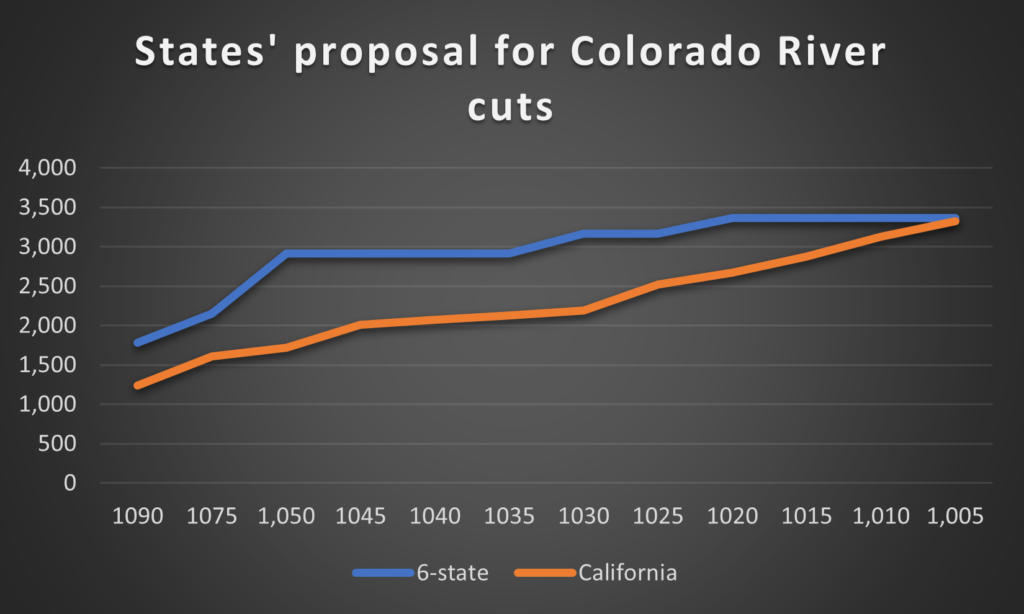
states’ proposal for Colorado River cuts. Lake Mead elevation along the x axis, millions of acre feet of cuts along the y axis
Getting ready for an interview this morning with Mark Brodie at KJZZ (waving at my Phoenix friends!) I put together a table to make it easier to compare the six-state proposal submitted Monday to reduce Lower Colorado River Basin water use, and the California proposal submitted yesterday (Tues. 1/31/23).
Perhaps worth sharing here? “Elevation” is Lake Mead elevation, the numbers are million acre feet of total cuts.
Two keys to note.
First, despite big disagreements about how to approach this, we have unanimity among all seven states that very deep cuts in Lower Basin water use are needed. At the lowest Lake Mead elevations, the numbers are similar.
The difference is in timing. California’s cuts don’t kick in until later – essentially a gamble on good hydrology once again helping us avoid conflict by letting us use more water in the short term.
The six-state proposal says “go big” any time Mead drops below 1,050. The California proposal doesn’t start “going big” until 1,025.
The six-state proposal yanks the bandaid off now.
Under the current “most probable forecast” for the coming year, we’d end up in 2024 with:
- Six state proposal: 3,168 million acre feet in cuts
- California proposal: 2,188 million acre feet in cuts
| Tier | Elevation | 6-state | California |
| Tier 0 | 1090 | 1,784 | 1,241 |
| Tier 1 | 1075 | 2,156 | 1,613 |
| Tier 2a | 1,050 | 2,918 | 1,721 |
| Tier 2b | 1045 | 2,918 | 2,013 |
| Tier 2c | 1040 | 2,918 | 2,071 |
| Tier 2d | 1035 | 2,918 | 2,129 |
| Tier 2e | 1030 | 3,168 | 2,188 |
| Tier 3a | 1025 | 3,168 | 2,525 |
| Tier 3b | 1020 | 3,368 | 2,675 |
| Tier 3c | 1015 | 3,368 | 2,875 |
| 1,010 | 3,368 | 3,125 | |
| 1,005 | 3,368 | 3,325 |
There are other differences too – huge disagreements on how to approach the allocation of the cuts! No time for that this morning, I’ve a book to write, but I hope to get back to that in the next few days, stay tuned.
As always, if you find this content useful, be sure to hit the “like” button, it really helps the channel! (There’s not really a like button, that’s just what YouTubers say, it’s a family joke after I started teaching my classes over Zoom back in the pandemic.)
Hi John, thank you SO MUCH for putting this together…it would be great to hear about allocation differences too. BTW I cant find the ‘Like’ button!
Doug – click on the linked word “like”. It really helps the channel!
Recent hydrology and runoff data demonstrate that substantive use reductions must be implemented at higher Mead elevations. California has to be a big part of the solution – goes with being the largest water user in the basin. We need to quit thinking of the current situation as shortage; this is aridification. The proposal indicates some progress within California, but reducing use more, sooner may avoid a future crisis like the one we currently face.
There are a couple of aspects of the California proposal that stood out to me. As I see it they want to do as little as possible unless things get really, really bad. At that point the solution is to follow the status quo (cut off AZ, etc.) or roll out a new acronym – the VCCA or Voluntary Compensated Conservation Agreement. Here, CA recognizes that the water that makes up their “rights” does not exist but demands to be paid not to use it. Seems a bit fishy to me, but there is another wrinkle in the QSA. Under the QSA if cuts are mandatory they can be passed along to SDCWA’s share of IID’s water – a big money loser for IID. If they are somehow framed as being voluntary then IID can still send the full allotment to SDCWA and get all that cash. Personally, I think compensation for water that does not exist is not the best idea.
Financial compensation is one thing. But the cut in produce growing may reduce the nation’s food supply around 25% roughly. How does that get made up? Do those fruits and vegetables need to be imported? That sounds problematic not the least because it will cost more.
One possibility is massive amounts of desalination. California is already into that. Instead of handing out Federal tax payers dollars to dry farmers, maybe that money should buy desal plants. Another option is to pay for massive amounts of drip irrigation to replace flooding and sprinkling in the air. Solar panels and drip irrigation has been shown to coexist. California is planning solar panels over the canals. That is good. We need a WWII Marshall Plan.
Is any of this part of the current negotiations? Or, wait until it is too late, as usual?
Patrick – Your “reduce the nation’s food supply around 25%” is wrong – dramatically so. I made an attempt to run down the numbers on claims of this sort – which are frequently made – here: https://www.inkstain.net/2016/12/colorado-river-water-responsible-15-percent-u-s-crops/
It is almost certainly less than 2 percent. Importantly, though, there is strong empirical evidence that when water supplies shrink, Lower Colorado River Basin farmers continue to grow just as much produce, fallowing alfalfa – by far the largest crop but worth less money per acre/acre foot. During the last big cutback, in 2003, produce acreage actually went up.
Patrick:
I believe its too late already regarding climate change, given what we know from Earth and atmospheric sciences. Earth science provides context regarding past extreme events, whereas climate science provides us real time, data driven tracking of atmospheric changes. I would also agree that we need a type of World War II Marshall Plan, in fact, we had suggested that in our comments to the Secretary of the Interior via the White House last year:
Submitted comments:
DOWN 3 IN 23 28AUG22.pdf
https://1drv.ms/b/s!AvQl8ZrmMAdbj1s3YKXNM_wrvwRk?e=VVbpdm
Response from White House
Joe Biden Letter.PDF
https://1drv.ms/b/s!AvQl8ZrmMAdbsmugwYemqHqi9QGc?e=HeqPRg
Thanks John. My bad! I think I had in mind the amount of water reduction (2-4 maf) that has been discussed. Then, I should have stated Col Basin ag rather than country wide. I just did a little research on Imperial Valley Ag. One figure is 2.8 maf of Col.River water per year. It occurred to me that they must produce more than one crop per acre per year. Some alfalfa, one of the biggest crops, is cut 9 times per year. Other crops are rotated so that something is growing on the same ground most of the time. Let’s just say that there is a potential for a big cut in production that would impact our grocery store produce departments significantly.
But to the larger point, is anyone doing this analysis and looking at the national markets. Increased temperatures are predicted to lower yields and the nutrition of the crops that will grow.
Thanks again for the correction.
https://californiaagtoday.com/alfalfa-and-water-imperial-county/
“California Ag Today”
Interesting fact. They use an average of 5.6 af of water per acre of land. Picture the field with a lake 5.6 ft deep on it. Wow!
Thanks John for the chart. I think you should do one showing/comparing the cuts to Arizona’s allocation proposed by the 6 states and California. How different are they?