
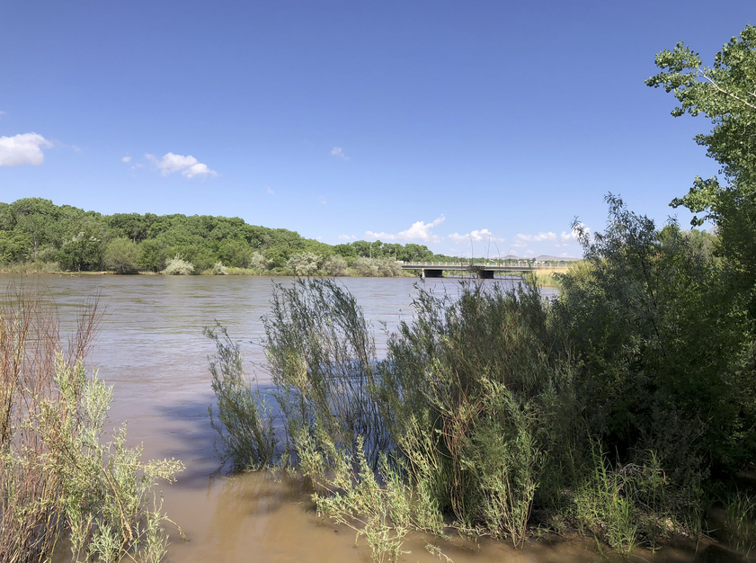
Rio Grande overbanking at Albuquerque’s Central Avenue Bridge, June 2023
We’ve been having a great year on the Rio Grande through Albuquerque, with overbanking flows to delight the river nerds and mosquitos alike.
But this is about to change. Beginning next week (June 26, 2023), the Army Corps of Engineers will begin dropping flows out of Cochiti Reservoir, the main stem dam upstream of town.
The Institutional Hydrograph
“Hydrograph” is the water nerd term for a graph that shows the flow of a river, with time on the x axis and flow on the y axis.
A “natural hydrograph” on a river like the RIo Grand shows base flows in winter, a rising limb beginning in spring as the snow melts, dropping by usually around this time of year as the last of the snow comes off. Then we dwindle back toward base flows, plus whatever ups and downs we get from the summer rains.
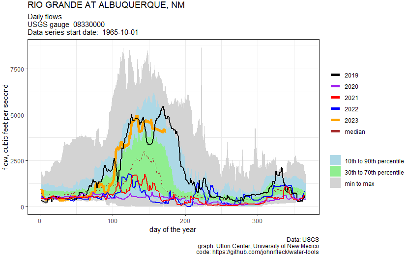
A hydrograph of flows this year on the Rio Grande through Albuquerque.
The “institutional hydrograph” is a term we might have made up, or maybe borrowed from somewhere I don’t remember, that explains how water management rules reshape the curves.
The rules here are many, and they interact in complicated ways. If you look at my graph (click to embiggen it), for example, you see a weird bump in flows every winter. That’s water being moved downstream to meet the requirements of the Rio Grande Compact. That’s an institutional hydrograph – rules, not the natural system, defining the flow of the system.
Overbanking and rules
The Rio Grande Compact is one of the drivers behind the strange hydrologic pattern we see in the Middle Valley right now – a main channel full of water, which in many places rises high enough to get up out of that main channel and flow back into the woods.
The river’s current configuration – a 600 foot wide main channel, with long strips of cottonwood forest on either side – is the result of state and federal management decisions in the 1950s to narrow and straighten the river’s channel, to more efficiently move water downstream to meet our Rio Grande Compact obligation to the pecan and chile farmers in southern New Mexico and folks in Texas. (I’m in the midst of writing that chapter of our new book Ribbons of Green.)
In olden times, before we did all of this, what we now call “yay overbanking” was called “Menace! Flood! Our adobe houses are melting!”. But with the dams and levees in place, I can now enjoy with relatively minor inconvenience of my bike trails being underwater and swarms of mosquitos.
What comes next
Current releases are about 5,000 cubic feet per second, but on Monday the Corps plans to start dropping releases by 500 cfs per day until inflows equal outflows. There’s still about 30,000 acre feet of water sitting in Cochiti, water held back to manage the risk posed by high flows downstream. After July 1, that water will sit likely remain in Cochiti until next fall, after the irrigation season is over.
So beginning July 1, we’ll be operating the Middle RIo Grande as an inflow-outflow system. I will not try to explain the rules in detail that are in play here, because I’ve not done the due diligence to be sure I’ll get the explanation right. I’ll save that for later, for the book.
But know that if you are in Albuquerque and are enjoying the overbanking and high flows, get out to see it in the next week.
It would be interesting to look at how the estimated yearly rainfall has changed along the Rio Rancho in recent years. If you look at Rio Rancho, for example, you can find it reported as low as 7.8 in/yr. At USclimatedata.com it is reported are 11.6 in/yr. The city of Rio Rancho pegs it as 12 in/yr. And redcross.org pegs it a 13.85.
So which is it? In my opinion, rainfall has been increasing, possibly as a response to higher pacific ocean temperatures from climate change generating more clouds, a greater percentage arriving to NM before dumping their rain. But that is just a conjecture. Would be nice to see your take.
Yeah. They will let it sit in those big reservoirs to benefit the boaters and water skiers while the water evaporates and blows off to Texas. Thank you Senator Domenici.