Lake Mead at 1,081.89 feet above sea level and dropping: Is this unprecedented?

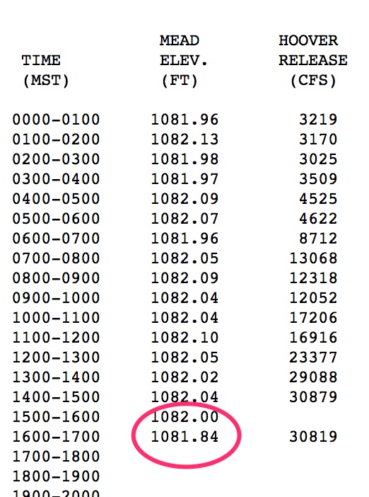
update: With the latest hourly reading, the elevation of Lake Mead has dropped to 1,081.84 feet above sea level, the lowest it has been since the reservoir was being filled in the 1930s:
With apologies to Emily Green, Lake Mead - Low Bad

With apologies to Emily Green, Lake Mead – Low Bad

Previously: Last night at midnight, the surface elevation of Lake Mead dropped to 1,081.89 feet above sea level, half an inch above the previous record low of 1,081.85 set around 9 p.m. Nov. 27, 2010 (source pdf). There’s a certain ebbing and flowing as water flows in from upstream and flows out to run turbines and water downstream farms, so I can’t say with precision when we’ll break the old mark, but by some time tonight or early tomorrow, it’s likely to drop past the record.

This already generating a lot of attention, and is likely to generate more as the record is set. (I had to wait in line this morning behind a TV station when I wanted to talk to one of the key basin water managers. I am not in a hurry. I am writing a book, which has a looser deadline.)

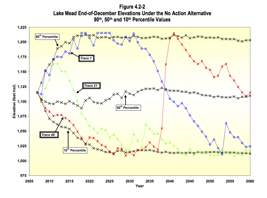
One of the truisms you will likely hear is that the drought since 2000, which has contributed to Mead’s decline, is unprecedented, outside of the historical record and therefore something water managers could not have been expected to plan for. But I recently ran across an interesting graph from the Bureau of Reclamation that suggests that may not be quite right. If we take the estimated river flows of the drought conditions that spread across the Colorado River Basin in the 1930s and early 1940 and overlay them atop a 21st-century water management system, Lake Mead would actually drop faster than it is today.
Simulated Lake Mead levels, courtesy USBR

Simulated Lake Mead levels, courtesy USBR

Take a look at the blue line and circles in the graph to the right labeled “Trace 1”. (Click to blow it up if you need to, I can wait.)

This is from the 2007 Final Environmental Impact Statement for the Colorado River Interim Guidelines for Lower Basin Shortages and Coordinated Operations for Lakes Powell and Mead. (source) The hydrologists created a series of synthetic data series and plugged them into a modern river system operational model – dams, water users and all – to see what would happen to Lake Mead in the future under various inflow scenarios.

Look at how that blue “Trace 1” line crashes beginning in 2031. That is a simulation of what would happen to Lake Mead if the drought of the 1930s-1950s was repeated in the 21st century. Under that scenario, it takes Lake Mead 14 years to drop from full to a surface elevation of 1,075. The current best estimates are that we could hit 1,075 in 2015 (source pdf), 15 years after it was last fullish in 2000. But what’s got to be unnerving if you’re a water manager is what happens to Trace 1 after it hits 1075. Under that historical hydrology, Lake Mead kept dropping for nearly a decade.

So what’s happening now is essentially equal to, but perhaps not worse, than, the worst case in the historical record.

Caveat: Here’s where the apples and oranges mix. The “Trace 1” scenario, in addition to taking the historical hydrology, presumes some expansion of water use in the future. So by 2031, when Trace 1 begins its crash, there is perhaps ~250,000 acre feet of additional water use in the Upper Basin that is included in the model.

Jagger, Richards and Steinberg on the California water bond

California state senator Darrel Steinberg on the California water bond:

In the water world, you can’t always get everything you want, but there’s a whole lot in this bond that California needs.

Mick Jagger and Keith Richards on (I think) taking a lot of drugs and getting laid:

You can’t always get what you want
But if you try sometime you find
You get what you need

Characteristics of a good water policy solution

Helen Ingram and colleagues on a few necessary conditions for a good solution to water management issues:

Good policy design contributes to three key public needs: progress in problem solving that will make tomorrow’s challenges easier than today’s; representation of sufficient interests, so that the policy has a positive balance of support and is politically feasible; and empowerment of the people affected, so that they can become engaged and better able to resolve their own problems.

That’s from Divided Waters, the excellent 1995 book by Ingram, Nancy Laney, David Gillilan about the specific water management problems of the twin cities of Nogales in Arizona and Sonora, and about transboundary water management challenges more generally.

How much rain did Albuquerque get last night?

It’s monsoon season here in New Mexico, which means thunderstorms popping up here and there and, one hopes, everywhere around the state.

In my blog stats, I notice that around this time of year I frequently get traffic for people searching for things like “how much rain did Albuquerque get today”. I’m writing this as a sort of permanent archive, hoping that some of you will find it via the Google on days like today.

One of the problems with this question during the summer is the extreme variability of thunderstorm precipitation. You can get dumped on, and a neighbor a few blocks away can get very little. The best way to find out how much rain you got is to get your own rain gauge and join the CoCoRaHS network of volunteers. Info on signing up can be found here.

If you want to see what all the other CoCoRaHS volunteers reported, the site has frequently updated maps. If you click on the map on the bottom, you’ll get a Google map for the state and can zoom in and see the reports for your neighborhood. Albuquerque has a pretty dense network of volunteer observers, so it gives a nice look at the spatial variability of these storms. Lots of CoCoRaHS observers only report once a day in the morning, so it’s best for getting a “how much did it rain yesterday and last night” readout. It’s my favorite.

The National Weather Service reports data for the “official” Albuquerque rain gauge, which is at the airport. Given the spatial variability, this can be disappointing. (But it didn’t rain at my house!)

If you want to watch as the storm is in progress, the Weather Service radar page is great. Click on “1-Hour Total” and “Storm Total” in the left-hand rail to get the radar estimate of how much rain has fallen.

Utah and California, sharing a watershed

I’m not sure “Utah shouldn’t build that pipeline because California might need our water” sounds like a winning political argument, at least if you’re having the argument in Utah. I’m not saying it’s not accurate. Overdevelopment of Upper Colorado River Basin water right now clearly poses a risk of colliding with the Upper Basin’s obligation under the Colorado River Compact to deliver water past Lee’s Ferry for use in California, Arizona and Nevada. I’m just talking about the political optics of California Drought Causes Need For Water Conservation In Utah:

California is in the grip of a record drought, causing the need for Utah to conserve water.

In Southern California, dry farms and cities depend on water from the Colorado River. Other states rely on the river as well, including Utah.

Environmentalists say the big California drought means Utah should be extra careful about project needing to take more water out of the river.

What water sharing and collaboration can look like

No Endangered Species Act litigation required for this project on the Rio Grande in southern New Mexico:

The Rio Grande is recovering some native vegetation with irrigation water typically used by farmers.

The International Boundary and Water Commission oversees water treaties between the United States and Mexico. But lately the agency has invested in river restoration projects.

In southern New Mexico it’s buying water rights from local land owners and using it to irrigate native vegetation.

“We’re not going to be growing cotton, we’re not growing chiles, we’re growing the environment,” said Edward Drusina, the U.S. Commissioner for the IBWC.

Here’s some background from a story I wrote last summer on the project:

The deal, negotiated over the last decade by environmental groups led by the Audubon Society and the irrigation district’s farmers, is the largest New Mexico example to date of a growing effort across the western United States to reclaim water for riverside environments.

By setting up programs under which willing farmers can sell their water on a short- or long-term basis, the agreements are an effort to sidestep farmers-versus-environmentalist battles that have dominated politics in some western river basins.

“As the water supplies decrease, shifting some water back to nature will be needed to keep the riverside habitats alive and healthy,” said Beth Bardwell of the Audubon Society.

Key message: this is not a lot of water or habitat at this point, but it takes time and experience to build the institutional plumbing needed to make stuff like this happen.

Wildfire smoke at dusk

Not a big fire, or a bad fire, at least not yet. Until humans arrived in force to change things, fires were common in those mountains. It’s a fire-adapted ecosystem.

We’ve got to get used to the smoke.

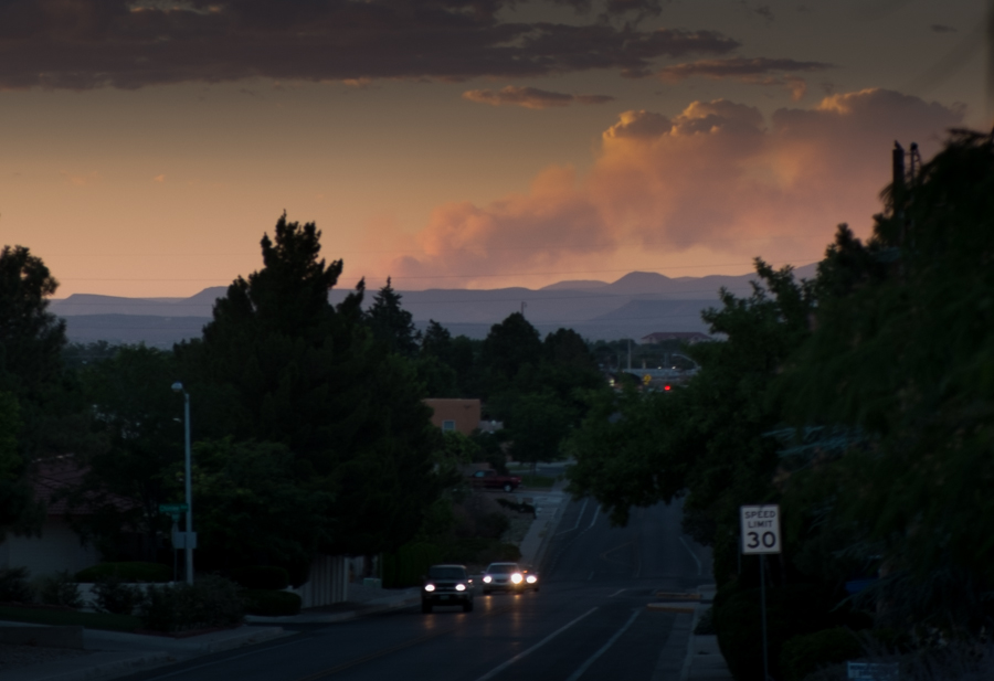
The Diego Fire, in the Jemez Mountains north of Albuqueruqe, June 29, 2014

The Diego Fire, in the Jemez Mountains north of Albuqueruqe, June 29, 2014