Border arbitrage

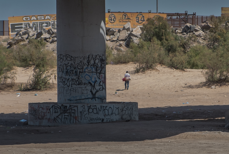
Guy on the move beneath the San Luis Bridge on the U.S.-Mexico border. John Fleck, March 2014

Guy on the move beneath the San Luis Bridge on the U.S.-Mexico border. John Fleck, March 2014


I’m not positive, but I’m reasonably certain the guy with the bedroll in this picture is performing arbitrage. He was sleeping out the midday sun under the San Luis Bridge on the Sonora-Baja-Arizona border before I saw him pick up and head toward those bushes on the Colorado River’s east bank. Just beyond that array of fences is an Arizona farm, where workers are paid substantially more than they are paid on this, the Mexican side of the border.

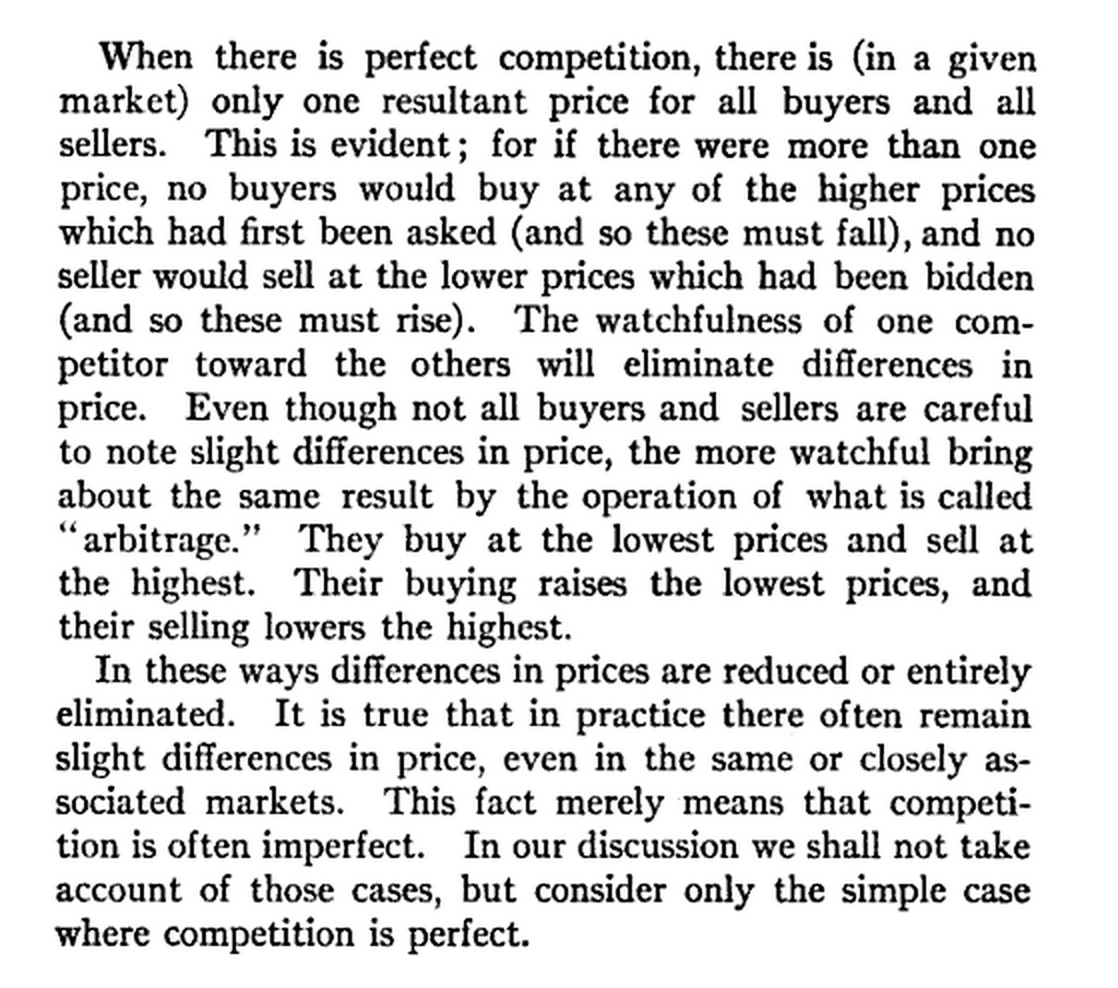
Here’s how Irving Fisher explained this in his “Elementary Principles of Economics“:

Elementary Principles of Economics

Elementary Principles of Economics


Competition, in the case of our friend with the bedroll facing the border, is not “perfect”, to borrow Fisher’s word. The fence, and the Border Patrol patrolling the no-man’s land between the fence and the Colorado River, have the effect of preventing the easy transaction of Bedroll Guy’s business. But if he can slip past the border fence defenses, he can sell his labor for a substantially higher price.

This very practical exercise in arbitrage, carried out many times over along the U.S.-Mexico border, has enormous implications.

Gatsby and the Colorado River

In December of 2002, an effort to sort out the problems of the Colorado River appeared as though it was about to blow up. California had long been living beyond its means (using more than the 4.4 million acre feet minimum guaranteed under the Law of the River). The deal would have given California time to reduce gradually – they called it a “soft landing”. But the deal had to be accompanied by a binding California commitment to really get to 4.4.

At the last minute, California tried to insert weasel clauses into the deal, known as the QSA, that would have given them the “soft landing” surplus water now but would have given them a way to wriggle out of their 4.4 maf commitments later. This had happened before – close to a deal, then a “but wait, this one more little thing” from California. On Dec. 9, Assistant Secretary of the Interior Bennett Raley wrote this in a letter to California:

The Department has no interest in a QSA that does not represent a long term Quantification of the parties’ portion of California’s apportionment of Colorado River water, lest in fifteen years we find ourselves as Gatsby did – ‘So we beat on, boats against the current, borne back ceaselessly into the past.’

I am indebted to An Upper Basin Perspective on California’s Claims to Water from the Colorado River Part II: The Development, Implementation and Collapse of California’s Plan to Live within Its Basic Apportionment, a remarkable history by Jim Lochhead.

Stuff I wrote elsewhere: moving groundwater in New Mexico

The Augustin Plains Ranch project, New Mexico’s version of a trend toward meeting urban needs in the west by pumping rural groundwater in to cities, is taking another whack at winning state approval after losing resoundingly two years ago:

A for-profit group hoping to pump New Mexico groundwater to the Rio Grande Valley and sell it to thirsty cities has asked state water managers for a new hearing on a proposal the Office of State Engineer turned down two years ago.

Augustin Plains Ranch LLC, an investment group that includes the owners of a ranch near Datil in the high country west of Socorro, is again proposing to pump groundwater and send it through a pipeline that would follow the Rio Grande north to the Albuquerque metro area.

The new proposal seems to have the same deficiency that caused the previous one to go down in flames – the failure to identify a “place and purpose of use”, something the State Engineer said was essential to state review and approval of the water transfer:

Augustin Plains Ranch repeats its prior approach – listing all possible water uses in much of a seven-county area from Socorro to Santa Fe. The ranch, in its filing with the state, said it hopes to win preliminary approval for the application before specifying who will use the water, and where.

That drew quick criticism from attorney Bruce Frederick with the New Mexico Environmental Law Center in Santa Fe, who represented a number of the 248 people who protested the group’s previous application.

“The application is a public relations piece and suffers from the same basic legal deficiency as the prior applications – the ranch has again failed to identify any actual place or purpose of use of water,” Frederick told the Journal.


Prior appropriation: alive and well at the Colorado River basin scale?

tl;dr The 1922 Colorado River Compact was supposed to sidestep the “doctrine of prior appropriation”, assuring slow-developing Upper Colorado River Basin states that their fast-growing downstream neighbors wouldn’t lock up all the water. But while that may be true on paper, 21st century reality suggest “prior appropriation” is back.

longer: Bret Walton’s Circle of Blue piece last week on Colorado River Basin water use plans as Lake Mead drops makes clear the states of the Upper Colorado River Basin – Wyoming, Utah, Colorado and New Mexico – will never get the water promised them under the 1922 Colorado River Compact. The result is a sort of de-facto “doctrine of prior appropriation”. By building quickly into their full share, the states of the Lower Basin – California, Nevada and Arizona – may have effectively pre-empted their Upper Basin neighbors:

Utah — like fellow upper basin states Colorado, New Mexico, and Wyoming — is not using all the Colorado River water it was granted by a 1922 interstate compact. The four states have the legal authority to increase their Colorado River diversions.

However, the water they seek may not be available. The calculations of availability stem from wetter hydrological conditions and supply forecasts made nearly a century ago. Under the 1922 compact, the upper basin is entitled to 7.5 million acre-feet. A later agreement apportioned each state a percentage of the available supply. The upper basin’s average annual use between 2007 and 2011, the most recent figures, was 4.6 million acre-feet.

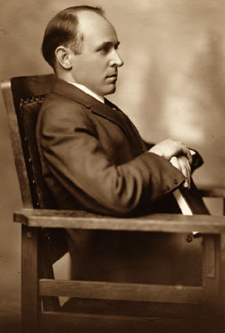
Delphus Carpenter. Picture courtesy Colorado State University library

Delphus Carpenter. Picture courtesy Colorado State University library

This is the outcome Colorado water lawyer Delphus Carpenter, the person arguably most responsible for the shape of the complex institutional plumbing governing the Colorado River, was trying to avoid back in the 1920s.

Dubbed by his biographer “the silver fox of the Rockies,” Carpenter was a small-town lawyer in Greeley, Colo., when a battle erupted between his state and neighboring Wyoming over water in the Laramie River.

Representing the Greeley-Poudre Irrigation District, this son of a homesteading irrigation farmer ended up arguing before the United States Supreme Court, defending Colorado’s water in a case that lead to the landmark 1922 decision in the case of Wyoming v. Colorado.

Wyoming had argued that, because its farmers had first put the Laramie’s water to use, their water rights should trump the Colorado irrigators who came after. The U.S. Supreme Court agreed, dealing a devastating blow to not only the Colorado farmers who had hoped to use the Laramie’s water, but to Colorado’s hopes for the future.

The battle over the Laramie was tiny compared to the growing conflict over the Colorado River, where tributaries flowed through seven U.S. states before discharging into the Gulf of California. Development patterns were happening unevenly across the region. If the “doctrine of prior appropriation” upheld by the U.S. Supreme Court in Wyoming v. Colorado was applied to the basin, Colorado and the other states feared fast-growing California would simply get it all.

Carpenter is the architect of the alternative: a compact among the states that divides the water evenly at the start, rather than giving it to whoever uses it first. It appeared at the time the compact’s drafters had sidestepped prior appropriation.

In the legal literature, prior appropriation has been a bit of a Schrödinger’s cat – “alive but irrelevant“, perhaps dead completely. And I’m stretching the argument to even invoke prior appropriation here. It’s not being invoked in the Colorado River Basin as a legal matter. It’s simply the practical nature of the thing.

California, Arizona and Nevada developed their full share of the river’s water. The other states didn’t. And now there’s no water left.

Click for more background:

So did Lake Mead break the record yet or not?

At this point it’s just a parlor game, but has Lake Mead broken through the old “lowest since they filled it” record yet or not? Regardless of the fractions of an inch involved, it’s a big deal. (Go to Circle of Blue for an explanation.) But the conversation this week has been a bit confused about whether we’ve actually crossed this milestone or not.

Here’s how the Bureau of Reclamation put it in their official news release Tuesday:

BOULDER CITY, Nev. – Lake Mead, the reservoir created by Hoover Dam, is anticipated this week to reach its lowest water level since the lake’s initial filling in the 1930s. The Bureau of Reclamation’s Boulder Canyon Operations Office is projecting the elevation to drop to 1,081.75 feet above sea level during the week of July 7 and to continue to drop, reaching approximately 1,080 feet in November of this year.

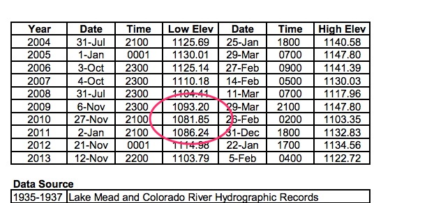
The old “record” was set in 2010, when Lake Mead bottomed out at 1,081.85 feet above sea level in the 9 p.m. hour on Nov. 27 (source pdf):

Lake Mead's previous record, courtesy USBR

Lake Mead’s previous record, courtesy USBR

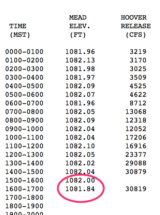
On Tuesday, the same day as the press release went out, Mead briefly dropped below that point, to 1,081.84:

With apologies to Emily Green, Lake Mead - Low Bad

With apologies to Emily Green, Lake Mead – Low Bad

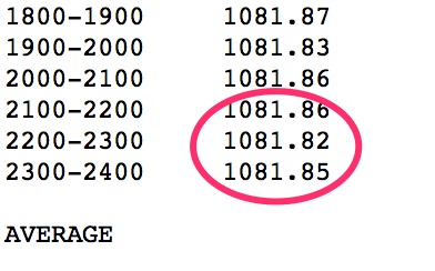
But it didn’t last, popping right back up. Hydrologists at the Bureau point out that the levels were bouncing around quite a bit, and there was a storm in the area, so maybe it’s questionable data? We’re talking tiny fractions of an inch here, which is why this is just a silly parlor game. On Wednesday, it briefly got as low as 1,081.82 before popping back up.

July 9 Mead levels

July 9 Mead levels

On Thursday it hovered above the old “record” all day (and it rained!). Today, it’s still above the old record.

Isenberg: Drought amplifies, not causes, water problems

Smart words from Phil Isenberg, California’s water sage:

[O]ur historic population and economic growth—and the social and individual choices we have made—explain the water and environmental problems we face today. Unless we acknowledge that water supplies are limited, and act to temper our water use, we will limp toward the next drought, and act surprised when it happens. Matching human expectations to the limits of nature is essential, but generally not politically popular.

The clash here is between public expectation and hydrologic reality:

Most policy-makers, even lesser ones like me, want to find popular solutions to com- plicated problems. That’s why we spend so much time talking about “win–win” solutions; the dream world where everyone gets whatever they want, and there is no need for taxes or fees to pay for the result! Sure, this is completely unrealistic. We know that.

However, we also know that public expectations— unrealistic or not—permit or block good policy changes.

AMACRQ: Can you move Colorado River water from one state to another?

For the latest “Ask me a Colorado River question,” a friend of Inkstain wonders:

Q: Can you move water from one Colorado River Basin state to another?

A: No.

OK, this is the Law of the River, so of course it’s more complicated than that, with numerous edge case exceptions, but basically, no, you can’t move water from one Colorado River Basin state to another.

The 1922 Colorado River Compact divided what the framers thought was a reasonable estimate of the Colorado River’s flow in half. States of the “Upper Basin” – Wyoming, Colorado, Utah and New Mexico – get 7.5 million acre feet per year, and state of the Lower Basin get 7.5 million acre feet per year.

The Upper Basin states subsequently got together to split up their share on a percentage basis:

  • Colorado 51.75%
  • Utah 23%
  • Wyoming 14%
  • New Mexico 11.25%

The Lower Basin states fussed and feuded and finally the Supreme Court stepped in and said:

  • California 4.4 million acre feet
  • Arizona 2.8 million acre feet
  • Nevada 300 thousand acre feet

Each state then is left to its own devices to divide up its own share internally, based on its own internal water laws and politics. But one of those devices cannot be to buy some extra water from one of the other states.

The result is that, to the extent that we’re seeing innovative water sharing and transfer agreements, they all tend to happen within a single state.

In Arizona, for example, the Wellton-Mowhawk and Yuma Mesa irrigation districts are involved in deals that involve water conservation and transfer to urban water users. In California, the Palo Verde Irrigation District has a program in which land can be fallowed and saved water shipped off to Los Angeles. The Imperial Irrigation District has an agreement in which agricultural water conservation measures generate water that is then used by urban users in San Diego.

I say they all tend to happen within a single state, though, because there are interesting edge cases where boundaries are being tested. Nevada and Arizona, for example, have a program in which surplus Nevada water is banked in Arizona aquifers for later use. Complicated accounting swaps ensue through which, on paper, no water crosses state lines. Wink wink.

New Mexico is currently considering developing a New Mexico unit of the Central Arizona Project which would involved diverting Gila River water within New Mexico, before it gets to Arizona, and then (again on paper) swapping that water with downstream CAP water.

But the most interesting test of these boundaries is an effort currently under development that Henry Brean wrote about in May under which urban agencies across the basin would pool their resources to fund conservation programs (most likely ag conservation) somewhere in the basin. The saved water would simply stay in the river for everyone’s shared use – “system water”. The result is that water conserved in State A might then be used in State B, but no one’s accounting for it specifically. It’s a clever workaround.

So the answer to the original question is really, “Not exactly, but people are trying.”

Background:

Stuff I wrote elsewhere – the Cooper’s hawks of Albuquerque

From this morning’s newspaper, a column about a day with a research team studying the Cooper’s hawks that are making an increasingly comfortable living around my city:

Cooper’s hawks are primarily woodland birds, and we have built an expansive urban forest across the Northeast Heights. The urban neighborhoods on the east side of the river are older, and therefore their trees are more mature, making them a better “forest” for the birds, Madden suggested.

The urban forest also makes great habitat for smaller birds – sparrows, finches, robins and especially doves and pigeons. Cooper’s hawks especially love the doves and pigeons.