Is the basin the wrong scale to look at Colorado River (or Rio Grande) system groundwater losses?

I think the answer to my rhetorical question in this post’s headline is obviously “no”. I think this is enormously useful data. But I’m still puzzling over who beyond clickbaiting bloggers like myself might use it, and how.

In his coverage of the GRACE Colorado Basin groundwater depeletion, Brett Walton at Circle of Blue included an interesting comment from Arizona’s Chuck Collum:

Chuck Cullom, Colorado River manager at the Central Arizona Project, which delivers more than half of Arizona’s Colorado River allocation, said the study was helpful.

“The study is useful in using GRACE to verify at a coarse scale what water managers in the Basin know,” Cullom told Circle of Blue.

I’ve been thinking about that because the new GRACE study triggered (yet again) a discussion among some of the local water nerds about the need for such a study on the Rio Grande, something I’ve told Jay Famiglietti and Stephanie Castle that I’d be really appreciative if they’d do. In the past, I’ve used some of their data in my newspaper work, but only in a very general way:

Groundwater across the entire state, especially on New Mexico’s east side, is dwindling, according to research by the University of California’s Jay Famiglietti, who uses satellites to measure changes in the aquifer, the fresh water underground that is pumped up for use on farms and in cities.

“The trend is pretty significant,” Famiglietti said.

I’d really love to have more detail, a Rio Grande Basin study like the one just completed on the Colorado, but Cullom’s comment got me thinking about who might actually use data at the basin scale. If management of groundwater is done at a state and local scale, and if Cullom is right that water managers at that scale already know what’s going on with their own groundwater, then what is a basin-wide number telling us that might be used in policy implementation that is different than the data local-level water managers already have?

Ag-urban transfers: “a significant fission of costs and benefits”

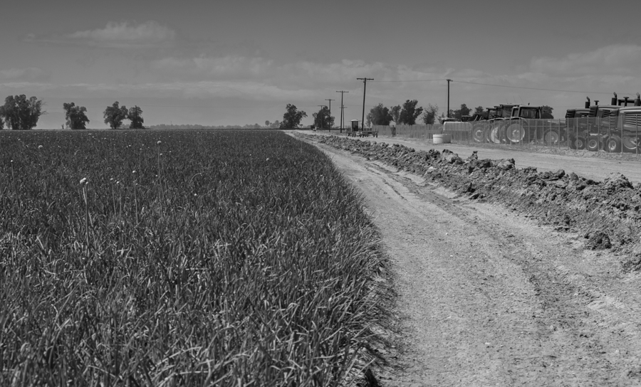
In ag-urban water transfers, does the tractor dealer lose out? Onion field and tractor dealership, Imperial Valley, March 2014, by John Fleck

In ag-urban water transfers, does the tractor dealer lose out? Onion field and tractor dealership, Imperial Valley, March 2014, by John Fleck

More from in Brian Devine’s excellent series on the tradeoffs, some quite hidden, in the agricultural-to-urban water transfers that seem the inevitable path forward in the western United States:

To many rural communities, water is more than just money. Irrigation is the lifeblood of rural communities’ economies, to be sure, but it is also a key strand in the fabric of community identities and the self-determination of rural places.

And this (“AMI” is “agricultural to municipal-industrial”):

Third parties – the employees and neighbors of those who choose to sell water, and who receive no cut of the sale price – therefore bear most of the economic burdens of AMI transfers. Removing the primary economic driver from these communities has little to no effect on productivity from a state or national accounting standpoint, but it can have a cascading effect on local capacity. Unsurprisingly, the effects are smaller when the receiving area and the origin are in the same economic region. This case is not uncommon as suburbs expand into and even “leapfrog” over agricultural operations. But the opposite case, where water is transferred many miles away along a stream, or even through a tunnel into entirely different watersheds, represents a significant fission of costs and benefits.

I tend to be optimistic about the role of ag-urban transfers, but these third-party effects can’t be easily waved away.

Stuff I helped write elsewhere: Endangered Species Act litigation on the Rio Grande

From this morning’s Albuquerque Journal (behind a GoogleSurveyWall for non-subscribers, sorry):

Citing “two decades of broken promises by federal and state water managers,” a Santa Fe-based environmental group filed a federal lawsuit against two government agencies Thursday alleging they failed “to secure dynamic and perennial flows for the Rio Grande” needed to protect the silvery minnow and Southwestern willow flycatcher.

Water managers of one agency say they have made major changes in how they operate, while another said it has spent at least $50 million over the past decade to protect the fish.

Policy implications of Castle and colleagues on Colorado River Basin groundwater depletions

Ever since we saw early glimpses last spring of data from Stephanie Castle, Jay Famiglietti and colleagues about groundwater depletion in the Colorado River Basin, I’ve been puzzling over the policy implications. Their data, published today in GRL, is worth an “OMG IT’S WORSE THAN WE THOUGHT!” While we’ve been watching Lake Mead’s bathtub ring grow and the basin has lost 12 million acre feet of stored surface water in the last decade, aquifers have declined more than 40 million feet, essentially unnoticed.

In a fascinating talk in the spring at the Bureau of Reclamation, Oregon State University’s Aaron Wolf, the guru of water conflict (or lack thereof) explained how his data showed collaboration and cooperation is far more common than fighting over water. The key thing to look for is how a basin’s water users are able to respond to change. Change can be abrupt, like flooding, or drawn out, like drought or the sort of inexorably rising demand that we’re seeing in the Colorado Basin. Actually, we’ve got drought too, so check that off. At this point you look to institutions:

There’s change in the basin. All the things you look for. Scarcity, floods, droughts, economic growth, tensions. Everything that’s going on. Managing that is a certain level of institutional capacity. How good are the agreements? How good are the relationships? How well do they work together? That helps mitigate the change…. The likelihood of conflict rises as the rate of change in a basin exceeds the institutional capacity to absorb the change.

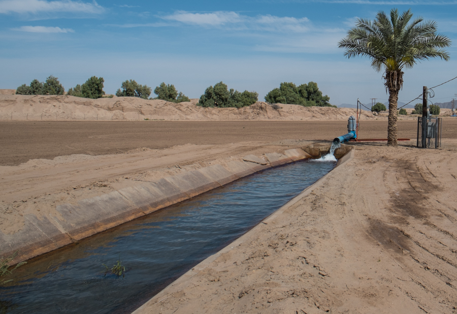
Pumping groundwater in the Colorado River Basin, March 2014

Pumping groundwater in the Colorado River Basin, March 2014

I’ve been arguing that one of the things we see in the Colorado River Basin is an institutional maturity that has thus far had the ability to absorb the changes we’ve seen to date – the 2001 Interim Surplus Guidelines that jiggered Colorado Basin allocations to rein in California’s overuse (pdf), the 2007 shortage sharing agreement, the remarkable Minute 319 deal with Mexico. Those institutions are now wrestling with the fact that none of this has been enough, which is why maybe this week we’ll see the announcement of a system conservation program deal that will be one more brick in that wall.

All of that shows the maturity, I think of basin-wide water management institutions. Only time will tell of that’s enough, but it’s the sort of thing Wolf’s research shows is a necessary precondition to success. But all of those institutions deal with surface water. What Castle and colleagues are pointing out is that groundwater drawdown is a huge unaddressed problem. And we’ve got no basin-wide institutions for that.

Maybe we simply don’t need them. One of the core principles of basin management is that we need these institutional arrangements because the Colorado River and its tributaries flow alongside or through nine different states. One of the key institutional approaches has been to set allocations at the states’ borders and leave each state to deal with its own internal allocations within its own state-by-state institutions. That’s where groundwater institutions lie. Each state has its own (and they’re widely varied – in preparing for this post I found a few reviews explaining how each state handles its own groundwater, and for now I’ll just categorize them as “tl;dr” – too long, didn’t read :-).

The short answer, then, is that if an individual state has permitted overpumping, that state is going to have to deal with the consequences. This isn’t a basin-wide problem, so much as seven individual problems, for seven individual states.

But even if that assessment is correct, it still becomes a basin-wide problem if groundwater problems at home make it more difficult for the states to make the water-sharing and curtailment decisions that are going to be needed to cobble together overarching solutions to the Colorado River Basin’s problems as a whole. Does groundwater depletion add a level of difficulty that exceeds our institutional capacity to absorb change?

What Castle and her colleagues have given us is enormously helpful, but it’s only the start. It’s gross data. To understand the implications, we really need to drill down now to a much more local level – who’s doing all this pumping, where, and what are the implications at a zillion local watershed scales?

That’s how we’ll figure out where we are on Wolf’s scale of institutional readiness to deal with a problem that’s bigger than I thought it was before I saw this data.

New data shows Colorado Basin groundwater loss greater than reservoir shrinkage

While we’ve been watching Lake Mead and Lake Powell drop during the last decade, the hidden reservoirs of groundwater beneath the Colorado River Basin have been dropping even faster, according to new research by Stephanie Castle and her colleagues at U.C. Irvine. Using gravity data from NASA’s GRACE satellite (the new tool all the cool kids are using to study groundwater), Castle and colleagues have posted up some striking data.

In the time period, they studied, 2004-13, they identified a total of 12 million acre feet of water lost as we drew down reservoirs. That’s the white bathtub ring in Lake Mead, the drop in Lake Powell, and the reductions in storage in smaller reservoirs – the stuff we can see. But they also found a whopping 40.5 million acre feet of loss in aquifer storage, as folks pumped groundwater to make up for surface water shortfalls.

This has significant policy implications, because essentially all the basin-scale policy discussions focus on surface water, while dealing with residual problems left by groundwater shortfalls left to state governance:

While the need to exploit groundwater resources to meet Basin water demands has long been recognized,  withdrawals required to meet current demands remain undocumented and are uncertain in the future. In particular, water management under drought conditions focuses on surface water  resources without a regulatory framework to manage  groundwater withdrawals outside of “river aquifer” systems. At question is  the potential impact of solely managing surface water allocations and diversions in the Basin,  without regard to groundwater loss, on meeting future water demands.

(I don’t have a link yet, will add one as soon as it’s available.)

Here’s a link to the paper, and Jay Famiglietti, one of the authors, has a writeup over at National Geographic. Also, AGU news release.

Pressure increasing to do something about a dropping Lake Mead

With a meeting coming up Friday of representatives of the seven Colorado River basin states, pressure is increasing to do something about the dropping reservoir levels in the basin, Tony Davis reports:

“How urgent it is depends on what you think the risk is,” said attorney Wade Noble, who has represented Yuma-area irrigation districts for 30 years. “If the risk is high that the water is not going to be there … then something needs to be done in the immediate future, not next year.”

The entire story is worth clicking for.


How well is California weathering the drought?

Peter Gleick runs down some of the impacts of California’s remarkable drought:

[W]ater still comes out of my tap, in unrestricted amounts and superb quality, at a reasonable price. And this is true of every resident in the state: drinking water supplies have not been affected, especially for the vast majority of the population that lives in cities of the San Francisco Bay area, Central Valley, and southern California.

But surely the agricultural sector has been hit hard?

While there will be some adverse impacts of some farmworkers and farmers, the overall agricultural sector will not have a bad year. Some farmworkers will be out of work this summer and fall, some farmers will be forced to fallow land because of the lack of water, and others will have higher costs associated with the need to replace surface water shortages with temporary groundwater pumping. But initial estimates from the University of California, Davis, the agricultural community as a whole will not see very large losses – a drop of perhaps 4% or so of normal farm revenue.

See, California, I told you that you can do this!

Brian Devine on ag-urban transfers

Ag-to-urban water transfers are one of the ways it’s easy to make the Colorado River Basin’s water math balance. Seventy percent of the water is currently consumed by agriculture. Just a fraction of that, transferred to use in cities (AMI, or “agriculture to municipal and industrial”), should make solving the problem relatively straightforward, right?

Brian Devine, who’s working on these issues at the University of Colorado, talks about why this is tricky in practice:

The question that needs answering is threefold. First, what are the impacts of a sizable AMI transfer on the community of origin, and on the purchasing municipality? This question is an empirical one with ecological, economic and sociological dimensions. Second, are these impacts, and the tradeoffs they entail, permissible? This is a theoretical question drawing on environmental ethics and a concept of justice. Third, what can be done to bring these impacts more in line with our ethical demands? This last question is a practical one that demands the promulgation of policy instruments which might have economic, political or ecological flavors. The fact that AMI transfers on a large scale are relatively new and have been the subject of rigorous examination only in the last several years, after scholars turned their attentions away from dams and pipelines, makes any definitive conclusions difficult. AMI transfers, like all water issues in the West, are highly dependent on geographic, political and historical context. Nevertheless, it seems clear that the pure form of water transfers that ignores consequences to third parties has serious harmful effects on areas of origin, effects that cannot reasonably be said to be outweighed by the gains made by receiving areas. Fortunately, there appear to be promising policy options for mitigating these consequences, protecting rural values at risk, and still allowing for the growth of urban regions.

The full piece is worth reading.

Eating the Colorado River shortage elephant, one bite at a time

This line from a paper a few years back by Edella Schlager and Tanya Heikkila may seem obvious, but in the context of current discussions over the future of Colorado River management, it bears repeating:

A water allocation rule that allocates more water than is available in a river is not well matched to its setting.
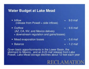
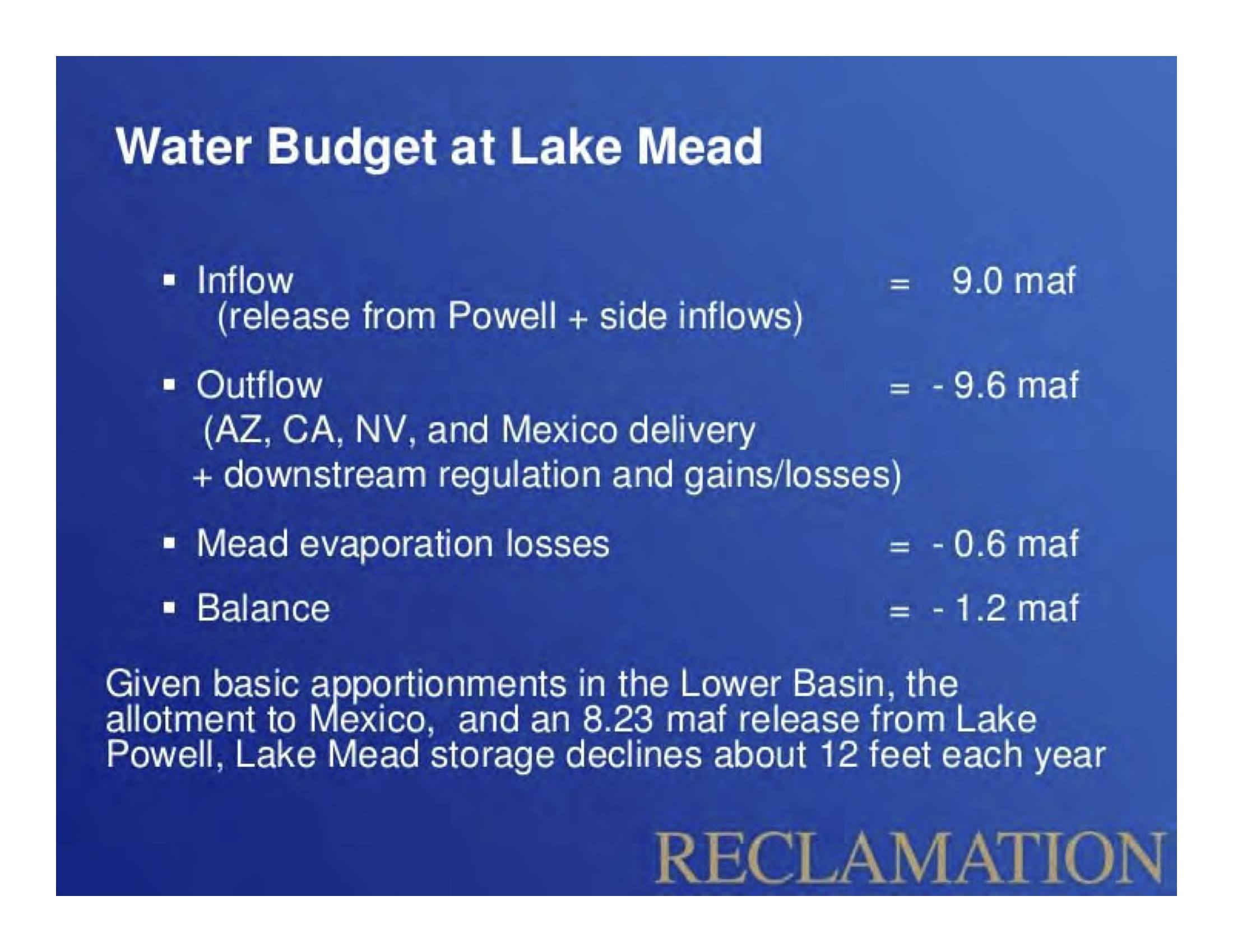
Lower Basin Water Budget, courtesy USBR

Lower Basin Water Budget, courtesy USBR

Yup. That in a nutshell is the problem highlighted by this oft-revisited Bureau of Reclamation slide demonstrating how the Lower Colorado River Basin’s water budget works. Everyone here is following the rules, living within their legal allocation, and Lake Mead keeps dropping because the Law of the River has allocated more water than is available in the river.

This is the critical thing to understand as we see the beginnings of the new “Colorado River System Conservation Program” taking shape, which would create a framework to pay farmers to leave water in the river. It’s not enough to simply save water. The way we go about it must be embedded within, and take into account, the rules governing allocation and distributions of Colorado River water.

Jim Lochhead, now head of Denver Water, wrote an excellent introduction to the problem a decade ago in a remarkably candid history of the Colorado River water wars of 1990-2003 (paywalled). In the early ’90s, it was clear that overuse was an increasing problem. The overuse then came in the form of California’s dependence on surplus that other states had not been using. Nominally, California’s allocation of Colorado River water was supposed to be 4.4 million acre feet of water per year, but since the 1950s, it had been dining on surplus left unused by other states. With Las Vegas’s growth and Arizona’s completion of the Central Arizona Project, the surplus was disappearing, and California had to figure out a way to get from the 5-plus maf it had been using most years down to 4.4 maf.
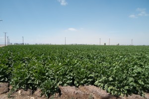
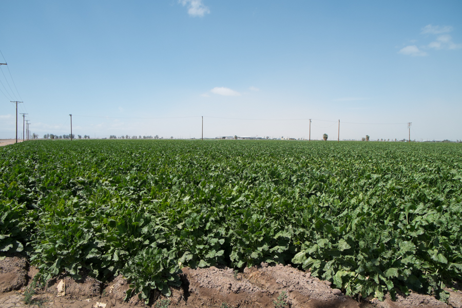
Imperial Valley ag still thrives despite drought and cutbacks in delivery of Colorado River water to California

Imperial Valley ag still thrives despite drought and cutbacks in delivery of Colorado River water to California

In the decade since that time, Southern California has been remarkably successful at making the adjustment. Coastal Southern California’s economy is still as robust as ever, even in the face of the current drought, and the Coachella-Imperial-Palo Verde farm belt is still thriving with big ag. The details of how they did it – the largest ag->urban water transfer in history – are interesting (buy my book! as soon as I finish writing it!). But a critical necessary condition, before the details of fallowing and ag efficiency were worked out, was the need for a change in the “water allocation rules” that Schlager and Heikkila are talking about. The water wars of 1990-2003 that Lochhead writes about were all about the basin states and the federal government realizing the water allocation rules were inadequate. One could argue that the “structural deficit” was in a sense even larger then, and that first round of action was about reducing it.

When you look at the size of the current structural deficit in that Bureau slide above – 1.2 million acre feet per year – the Colorado River System Conservation Program looks modest indeed. We’re likely to see more details as the agreements are finalized over the next week, but at the going price of water, the $11 million effort looks like enough money to generate 75,000 to 100,000 acre feet of water savings. It sounds like most of the initial attention will be initially be focused on the Lower Basin, with Reclamation hoping to issue “requests for proposals” this year to farmers interested in fallowing land for a price per acre foot of water yet to be determined. With Palo Verde, Coachella and Imperial all actively engaged in the already existing California ag->urban transfer programs, much of the action is likely to be on the Arizona side, especially Yuma and Wellton-Mohawk (though I’ve also heard mention of some possible interest across the river with the Bard Irrigation District, which is on the California side of the border but gets Yuma Project water).

When I asked recently whether 75k – 100k acre feet was enough, given a structural deficit an order of magnitude larger, one of the people working on the program pointed out that this is a pilot program, to learn how to do it, then added, “How do you eat an elephant? One bite at a time.”

The 1990-2003 experience suggests that the water conservation piece of this may be the easy part. As a nice new Western Resource Advocates white paper explains, we know how to conserve the water. The key piece here, and the reason the System Conservation Program is so interesting and important, is that we need to get the water allocation rules and river management policies right in order to cause those conservation savings to happen.