The river is the focal point — and reason behind — the town’s existence. Without it there would be no casinos.
During the summer months, the river is more of a factor in the Laughlin experience than at any other time of year. The all-too-easy-to-adopt thought that Laughlin is too hot in the summer is off the mark for those who love the water. This is the time of year the bathing suits come out, the boats and Waverunners rule and an overall energetic quality overtakes the casinos.
But you don’t have to own a boat or personal watercraft to enjoy the river. You can simply appreciate it by gazing as it flows by your casino.
The Colorado’s problems: if you’re not talking about alfalfa, you’re not being serious
Let’s revisit regulated deficit irrigation and the analysis Mike Cohen did last year of the problems and opportunities associated with forage crops in the Colorado River Basin, shall we?
Golf and the Bellagio Fountain are easy targets. But if you’re not talking about alfalfa, you’re not being serious. Here’s Cohen et al.:Irrigated pasture and forage crops, used primarily to feed beef and dairy cattle and horses, cover about two million acres (60 percent) of the irrigated land in the Colorado River basin. In Nevada and in Wyoming, pasture and forage account for almost all irrigated acreage; in Colorado and in Utah, more than 85 percent of irrigated acreage in the basin is in pasture or forage. We estimate that irrigated pasture and forage in the basin consumes more than five million acre-feet of water each year.
That’s more than golf.
But we don’t just go taking things away from people because we think we have a better use for the thing (at least we shouldn’t), and the farmers have reasonable expectations that we won’t just barge in and shut down their irrigation turnouts. In addition, communities have grown around these reasonable expectations. There are real equity issues here, but even if you disagree with that assessment, the reality is that we’re not going to get any sort of traction for Colorado Basin solutions that don’t take into consideration the political interests of the farmers.
What if there were a way to keep all that land in production and still save water? That’s where “deficit irrigation” comes into play as the Western Farm Press reported:
[D]eficit irrigation can be a good option for keeping land in production under dwindling water allocations.
“In some fields growers may be forced to deficit irrigate whether they want to or not,” Munk said. “The question is do we cut land from production or change our irrigation management through things like deficit irrigation?”
Traditional irrigation attempts to maximize the amount of water a crop can use. But when water supplies are constrained, the amount of crop per unit water can be optimized instead. For example, you can reduce alfalfa irrigation during the hottest summer months, when it takes a relatively large amount of water for a relatively smaller yield return. Alfalfa’s an insanely tough plant, plenty drought resistant. Deprive it of water in the hot summer months and it just hunkers down and waits for fall.
When the Central Arizona Project folks earlier this month rang the alarm bells about the problems of a dropping Lake Mead, they suggested we need to find somewhere between 600k and 900k acre feet of water to protect the system from the risk of collapse. Cohen et al. suggest you could get 970k acre feet of water per year by applying regulated deficit irrigation to alfalfa basin wide, or 834kaf by doing it only in the Lower Basin. Pay farmers for the water saved, to compensate them for the reduced yield.

Golf
I love this bit of business from Charles Fishman’s visit to Angel Park, a Las Vegas golf course, in his book The Big Thirst:
By the time a golfer steps up to the first tee, Angel Park has used 2,507 gallons of water to make that round of golf possible, 139 gallons of water for each hole of an eighteen-hole round, for each golfer, each day. A foursome of Angel Park golfers playing eighteen holes requires enough water to supply the needs of a typical U.S. family for a month.
Grover explains how to solve the Colorado River’s problems
Grover’s talking here about raisins, but I think it generalizes.
Lake Mead’s coming record low
Four years ago, I stood on Hoover Dam staring down at the receding water line as Lake Mead set what was, at the time, a record low:
If you blow this picture up enough, you can probably see pixels of rock that have not been exposed since the 1930s. Or maybe not.
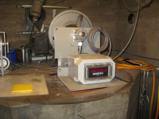
The surface elevation of Lake Mead hit 1083.18 feet above sea level today between 11 a.m. and noon Pacific time today, when this picture was taken. That is below the previous low – 1083.19 – on April 26, 1956. We can now unequivocally say that the drought of the ’00s and continued water consumption by downstream users has lowered the mighty reservoir to the lowest level it has seen since it was filled in the 1930s.
We’re about to do this again. In April, the surface elevation of Lake Mead dropped below the level for April 2010, and with each successive day, we set a new record for this point in the water year. By some time next month, Mead is forecast to drop below the 2010 record of 1081.85, set Nov. 27, 2010. I like to make graphs to help me visualize data:
With current estimated inflows and water use downstream, Lake Mead will end 2014 three feet below the 2010 record, and just eight feet below above the magic level of 1075 at which the first shortage declaration will be declared.
Why water governance fails
In his new book Chasing Water, Brian Richter offers an interesting list of the ways in which water governance fails:
- Insufficient Financial Capacity
If the government is not generating enough money from taxes or other means to meet these needs, or if the government simply is not allocating enough of its resources to the governing of water, water allocation and management systems are almost certain to fail.
- Lack of Expertise
The best-run water agencies in the world possess most or all of this expertise, employ hundreds of staff members, and operate with multi-million dollar budgets. But possessing such capacity is the exception and not the rule.
- Lack of Will to Enforce Rules
Enforcement of rules is almost always the weakest link in any system for managing water.
- Lack of Coordination among Authorities
[I]t is very easy for different governmental departments to become isolated into “silos” that do not communicate or coordinate well with each other.
- Too Much Corruption
Which of these problems does your community suffer from?
Las Vegas water rights not what they used to be
Las Vegas golf course developer selling water rights at $20,000/af (http://t.co/3wP6VliFTm) Lower price than 2012 (http://t.co/S8d4dg8rf6)
— Brett Walton (@waltonwater) June 24, 2014
In 2012 The Walters Group, a golf course outfit, offered millions of dollars of water rights at $25,500 per acre foot. Two years later, the going price seems to have dropped:
The Walters Group is immediately offering for sale 200 acre feet of fully transferable Las Vegas Water Rights at the rate of $20,000 per acre foot which is current market value. The water rights are fully transferable. The nature of these Las Vegas water rights is the most highly valuable designation for water rights available in the State of Nevada. Investors may elect to purchase these water rights in full, as single transaction of all two hundred (200) or in blocks of as few as two (2) acre feet.
I thank Brett Walton for bringing this to our attention.
Stuff I wrote elsewhere: It’s the farms
Farms in the Rio Grande Valley of central New Mexico consume nearly six times as much water as the region’s cities, according to a new analysis by a team led by a University of New Mexico professor.
And bosque plants, dipping their roots into groundwater and exhaling the water through their leaves, consume nearly three times as much water as cities, according to the study.
There are uncertainties in the numbers. Other experts say the analysis may overstate farm consumption, that agriculture consumes only four times as much water as cities, not six times, and that the bosque may consume as much as five times as much water as cities, rather than three.
But that should not obscure two central issues pointedly revealed by the new analysis.
First, farms and the bosque each use a lot more water than cities, and any water policy discussion in this water-scarce region must take that reality into account. Second, the uncertainty in the numbers should be troubling. The fact that we don’t have a clearer picture of our consumption of this scarce and important resource is a problem.
Why it’s not about the Bellagio Fountain redux – a peek into the solution space
Here’s The Nature Conservancy’s Brian Richter, in his new book Chasing Water, describing what the solution space for the Colorado River Basin’s water problems might look like:
Even though urban water uses (for domestic, commercial, and industrial purposes) account for only a minor share of total water use in most water-stressed places, urban water use is often growing much faster than agricultural use. The need for more water in cities and industries conflicts with the reality that agricultures is already consumptively using most of the renewable water supply. One of the options available to cities or industries wanting to access more water is to find ways to work with farmers to share limited water supplies. Ultimately, the economic, social, and environmental risks associated with water scarcity cannot be adequately addressed in many places without reducing the volume of water being consumptively used in agriculture.
Recall from yesterday’s discussion the relative size of Las Vegas and Imperial Irrigation District bars in the Lower Colorado River Basin 2013 water consumption graph:
There’s no way that urban conservation gets us out of this mess.
Colorado River history pic Sunday: If you don’t measure it, you can’t manage it

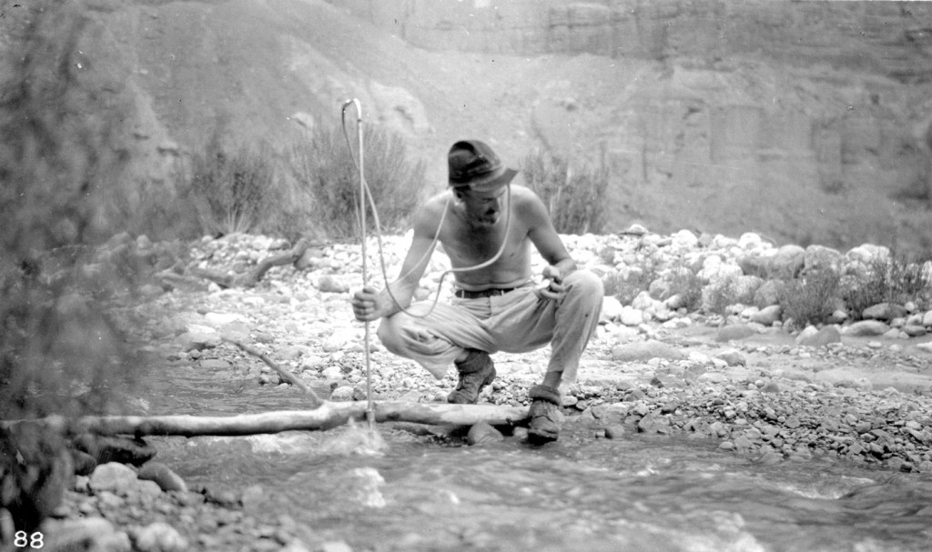
Grand Canyon National Park, Arizona. E.C. LaRue measuring the discharge of Nankoweap Creek. Every stream adjoining the Colorado River in the Grand Canyon region was measured. August 12, 1923. Colorado River Survey of 1923 (Birdseye). Courtesy USGS
I love this picture.
E.C. LaRue was a U.S. Geological Survey hydrologist who in 1916 assembled the first attempt at a rigorous scientific survey of the water resources of the Colorado River Basin. Water Supply Paper No. 395 will never be mistaken for great literature. LaRue was one of America’s early technocrats, intellectual ancestors of a thousand government employees and consultants today laboring over Federal Register Notices and Environmental Impact Statements. And yet, clumsily, LaRue reached for a grand vision when he opened the work with a five paragraph “Comparison With the Basin of the Nile.” This is no ordinary project we are embarking on, he seemed to be saying, but rather an opportunity to build one of humanity’s great societies.
In 1923, LaRue returned as a member of the Birdseye Survey, which returned to gather the data he had lacked when writing his 1916 report. But within a decade, he had left government service, frustrated by what he thought was the failure to listen to science. He thought evaporation would be too high at the Boulder Canyon dam site (what we now call “Hoover Dam”, which was really built at Black Canyon, not Boulder Canyon). He favored building the river’s first great dam at Glen Canyon instead.
Most importantly, LaRue argued that there was less water in the Colorado River than people thought.
- The Colorado River and its Utilization, USGS Water Supply Paper No. 395?