Beavers in the Colorado River Delta

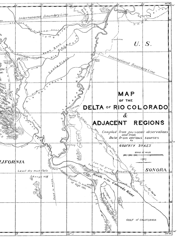
Godfrey Sykes, Map of the Colorado River Delta, 1905

Godfrey Sykes, Map of the Colorado River Delta, 1905

When Daniel Trembley MacDougal of the New York Botanical Garden rode a flood pulse through the Colorado River Delta in 1905, he found a puzzling landscape – one of the most arid regions of North America sliced through by “swampy jungles”. At a time when beaver was being trapped into oblivion elsewhere, it was a landscape that seemed to MacDougal to offer hope:

The area actually irrigated by the river in normal low water and flood … is surrounded on all sides by desert and salt water, and is in reality a biological island….

The quantity of food furnished by the swampy jungles is sufficient to support a vast amount of native animal life, and furnishes inviting feeding grounds for migrating birds. The countless millions of young willow and poplar shoots supply food for the beaver, which bids well to hold out long in the impassable bayous and swamps against the trapper foe.

Of course it wasn’t trapper foes who reduced the delta’s beaver population but dams upstream that choked off the “swampy jungles” and “impassable bayous”. But a survey done in the 1990s by Eric Mellink and Jaime Luevano found remnant beaver populations did hold out, sometimes even when the only water available was standing, stagnant pools. As long as there were willows and cottonwoods (MacDougal called them “poplars”) Mellink and Luevano found beavers.

When I toured the Laguna CILA (pdf) habitat restoration site in the delta last month, before the Minute 319 environmental pulse flow arrived, we saw a little beaver dam:
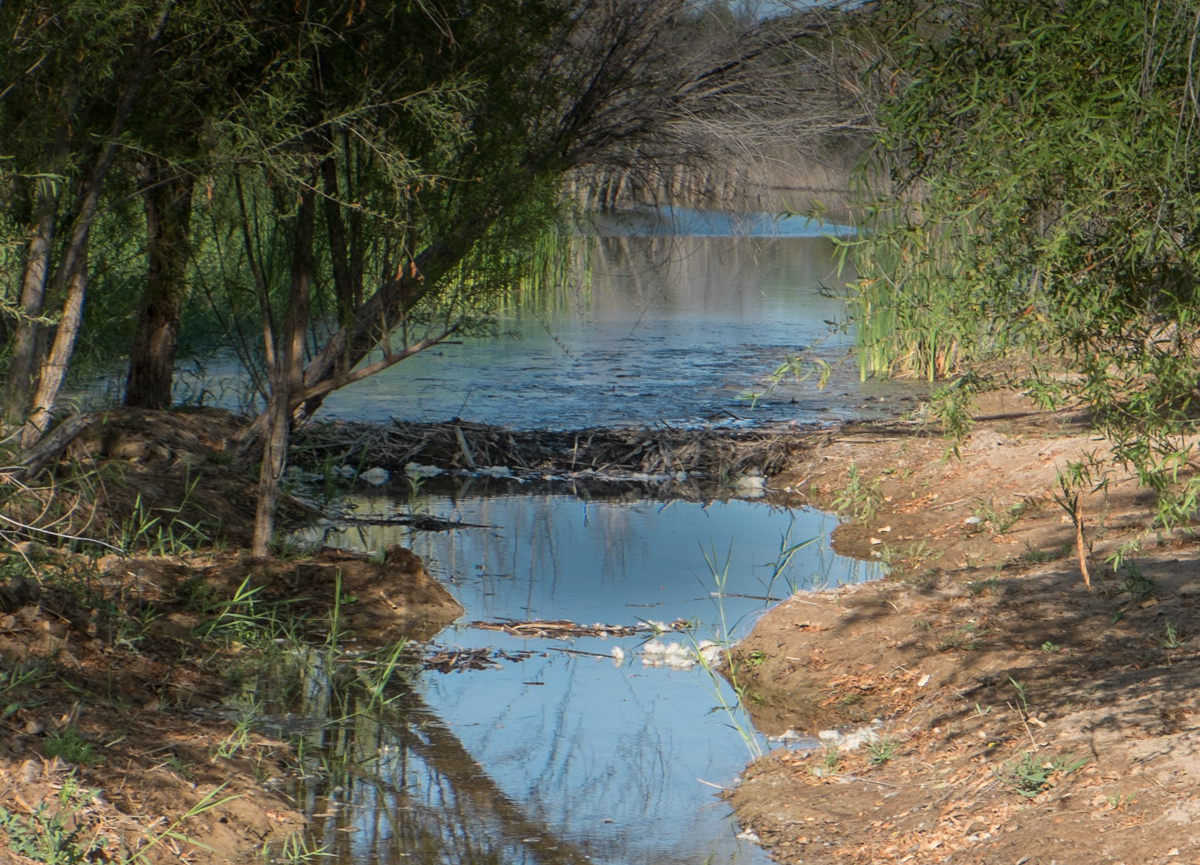
beaver dam at Laguna CILA site, March 27, 2014, by John Fleck

beaver dam at Laguna CILA site, March 27, 2014, by John Fleck


(Thanks to Steve Nelson for pointing me to the MacDougal paper.)

the palm is a water loving plant

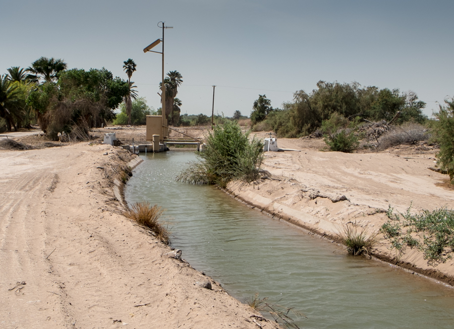
Irrigating a palm oasis from an Imperial Irrigation District canal, by John Fleck, March 2014

Irrigating a palm oasis from an Imperial Irrigation District canal, by John Fleck, March 2014

One of the fundamental propositions of date culture is that the palm requires a large supply of water for irrigation. This rule is apparently subject to some striking exceptions and future experiments will probably change our ideas on the subject still more, though they can hardly shake the fact that the palm is a water loving plant.

Date Growing in the Old World and the New, Popenoe and Bennett, George Rice and Sons Press, 1913

Colorado River System Conservation Program

We’re beginning to see details of a pilot program to conserve water in the Colorado River Basin to prop up declining water levels in the basin’s major reservoirs by paying water users to not use water.

The Southern Nevada Water Authority’s board last week approved that agency’s $2 million contribution to what would be a $13 million effort funded by the four largest Colorado Basin municipal water users – SNWA, the Central Arizona Project, Denver Water and the Metropolitan Water District of Southern California, each kicking in $2 million – and the U.S. Bureau of Reclamation, which would kick in $3 million.

A staff report last week from SNWA General Manager John Entsminger to his board (pdf) describes the program thus:

The purpose of the program is to determine if voluntary demand management actions (including agricultural land fallowing, curtailment of industrial uses, municipal conservation, etc.,) would be feasible to create Colorado River system water to mitigate the impacts of ongoing drought.

Las Vegas feels an acute need because dropping reservoir levels threaten its intakes, while everyone feels the drought pinch, Entsminger told his board.

Here’s how Kathryn Sorensen, water services director for the city of Phoenix, described it in a report to her city council this week (pdf):

Under the program, entities entitled to use Colorado River water would be compensated for voluntary reductions in water use, which would create conserved water that would benefit the system through increased reservoir levels. These increased reservoir levels then would forestall or mitigate future shortage declarations.

(h/t Betty Reid at the Arizona Republic for the mention of Phoenix’s interest in this.)

If this goes forward, it’s a potentially significant development in Colorado River Basin water management for a couple of reasons.

First, the mechanism on the surface looks a bit like the “Intentionally Created Surplus” and “Intentionally Created Mexican Allotment” (ICS and ICMA, and yes, they we really pronounce it “ick-ma”) mechanisms. Under those mechanisms, Lower Basin and Mexican water users can get credit for water conservation measures, creating storage banks in Lake Mead. But this new Colorado River Conservation Program would be different in a key way. The water saved wouldn’t be tagged as belonging to any particular water user. It would simply increase the overall amount of water available in the system for all users. (The pseudo-economist in me is curious about free rider problems. A subset of the basin’s water users are paying, everyone benefits. But that’s a subject for later, I guess.) The significance here is a general effort, with money behind it, to increase conservation in the basin as a whole, for the benefit of all.

Second, the effort crosses the Upper Basin-Lower Basin boundary. Denver Water is part of the deal. ICS and ICMA are entirely a Lower Basin/Lake Mead thing. Adding Denver and taking steps to prop up Lake Powell are a big deal.

Entsminger told his board the pilot program would begin this year and run through 2016.

An update on California towns running out of water. Or not.

The AP’s Jason Dearen has an update on California communities at risk of running out of water:

In February, the California Department of Public Health listed 17 mostly rural water systems as having less than two months water supply in storage.

But in recent weeks that number has fallen to three.

In February, as media coverage raged around 17 California towns at risk of running out of water in their drought, I ventured an observation and a prediction:

The observation:

[I]n a state with 38,332,521 residents, give or take a few, the fact that only 17 relatively small communities have so far been identified as being at risk of running out of water means that the vast majority of the state’s population is currently not at risk of running out of water in the next 60 to 100 days. In a drought this badassed, it so far looks like most of California’s residents will be able to flush their toilets and brush their teeth for the foreseeable future.

The prediction:

I’m going to boldly predict that most water providers will limp through to the finish line.

It rained, apparently enough to make me look correct. Best, in a situation like this, to be lucky.

(this post has been updated to move the news ahead of my ego)

El Niño and the Colorado River Basin

One of the epic Colorado River stories involves the Great El Niño of 1983, the year they almost lost Glen Canyon Dam. With a massive snowpack melting off in a hurry in June of that year, Lake Powell filled to the spillways, which couldn’t handle the load, and it is said we came close to catastrophe. (See John Weisheit, pdf)

As we head into what may be another big El Niño year, can we expect another big snowpack and a Powell-filling runoff? No.

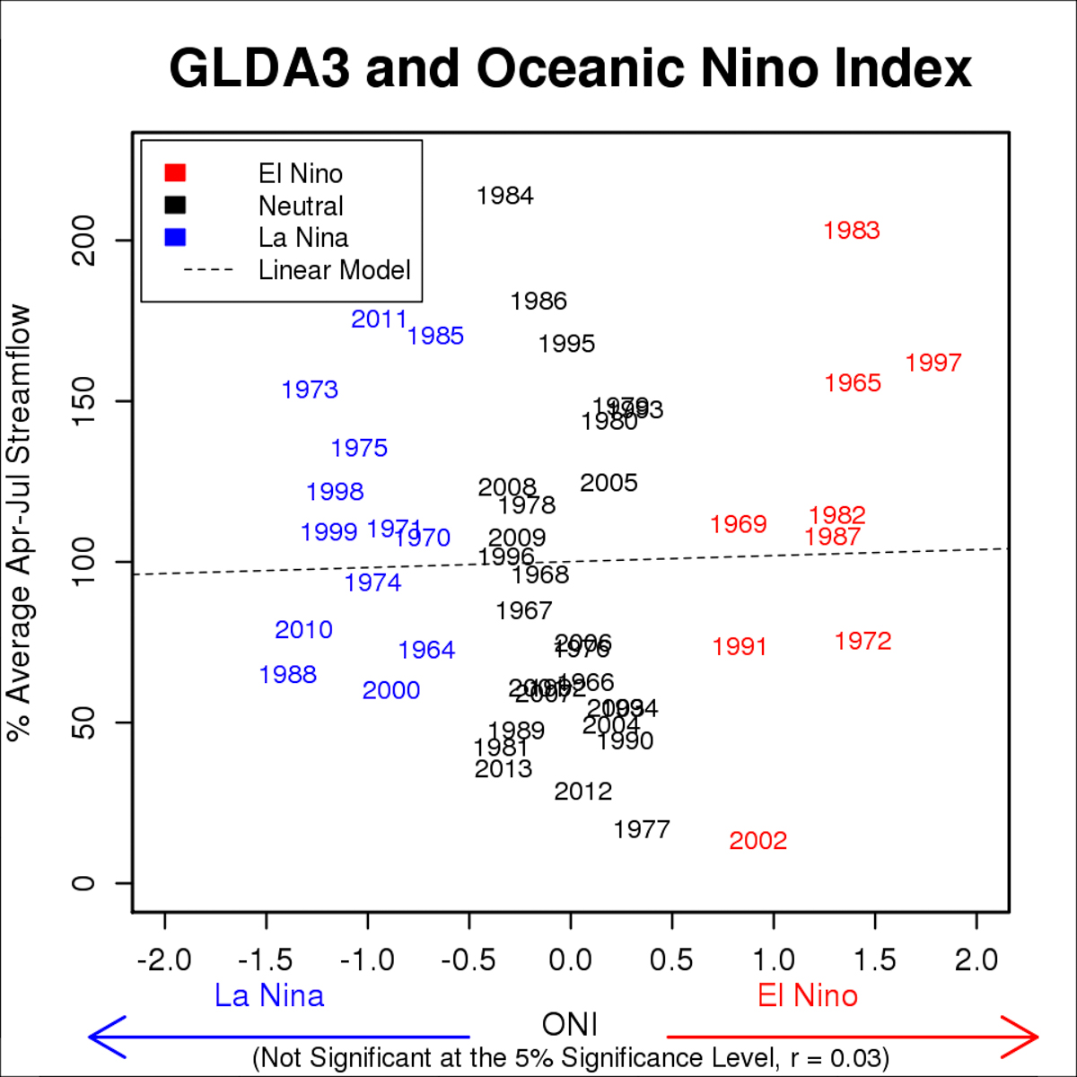
Paul Miller at the Colorado Basin River Forecast Center ran the numbers and sent along this graph of El Niño vs. La Niña and its impact on Colorado River flow:

Colorado River runoff and ENSO, courtesy Paul Miller, CBRFC

Colorado River runoff and ENSO, courtesy Paul Miller, CBRFC

“GLDA3” is CBRFC-speak for the natural inflow into Lake Powell – what you’d get if there were no dams. You can see 1983 hanging out there in the upper right – big El Niño, big runoff. But of the nine El Niño years in his data set, three were wet, three were middling, and three were dry. 2002, an epic dry year, was also an El Niño year. Here’s how Paul explains it:

There’s not a huge correlation between ENSO and the Upper Colorado River Basin, where we get most of our water supply….

But there is a bit of correlation in the Lower Colorado River Basin, which, hopefully, will provide a little extra water to the system. Maybe some of that water can be used to meet Mexico water deliveries or southern California agricultural demands, which could potentially reduce releases from Hoover Dam and Lake Mead.

stuff I wrote elsewhere: a dry summer on the Rio Grande

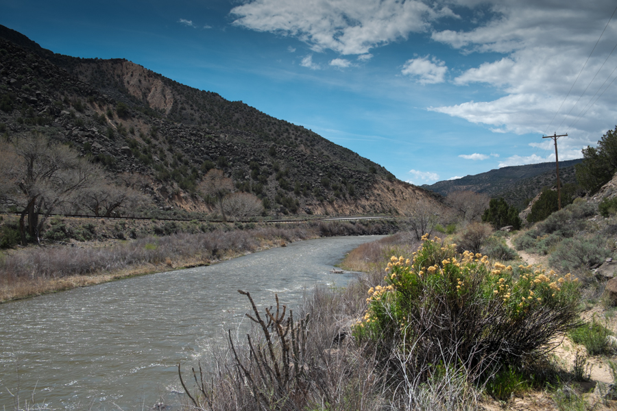
Here’s a picture of the Rio Grande, at Embudo, with water:

Rio Grande at Embduo, looking south, April 22, 2014

Rio Grande at Embudo, looking south, April 22, 2014

Here’s a newspaper story about the Rio Grande, at Albuquerque, without water:

Without good summer rains, the Rio Grande through Albuquerque could see its lowest sustained levels since the 1970s, water managers said Wednesday.

In the midst of the fourth consecutive year of extreme drought, agencies are scrambling to stretch limited supplies and looking hopefully at a National Weather Service forecast for good summer rains.

“We hope the National Weather Service prediction for an early monsoon is right,” said Mike Hamman, the U.S. Bureau of Reclamation’s area manager, at a water operations briefing. “But hope is not a plan.”

The headline writer got carried away with the math. It was actually September and October of 1978, when we last had sustained sub-100 cubic feet per second (~3 cubic meters per second) flow in the Rio Grande at the Albuquerque gauge. So 36 years, not 40, but I’ll forgive the rounding error.

“the groundwater problem”

Water is energy, and in arid lands it rearranges humans and human ways  and human appetites around its flow. Groundwater is a nonrenewable source of such energy. These facts are the core of the impact when groundwater is developed in such places. Humans build their societies around consumption of fossil water long buried in the earth, and these societies, being based on a temporary resources, face the problem of being temporary themselves.

To ask what is the impact of developing groundwater in arid lands is simply to seek the price that must be paid for this unique human knack of influencing the availability of water. The answer is this: man builds water-rich societies in arid lands by living out of balance with his water supplies. He uses water faster than it can be replaced by rain. When this fact becomes obvious, people call it the groundwater problem.

Charles Bowden, Killing the Hidden Waters, 1977


Whose river is the Animas?

Jonathan Thompson takes High Country News readers to his home town of Durango for a reprise of a western saga we’ve seen before: who gets to define the Animas River around which his city was built?

[I]t’s somewhat luxurious, maybe even decadent, to be able to have a community-wide fight over whether a park has a boat ramp or not, isn’t it? For me, there’s a special sort of irony in it all. Over the past 30 years, the river has morphed into a hybrid of the rule-free playground my friends and I cherished, and the community green space my father and his colleagues had envisioned.

“As Durango has become a destination for tourists and for those seeking a change in lifestyle,” wrote David Wegner, in his comments on the park plan, “the value of the Animas River increased. In a way, we are a victim of our success.”

stuff I wrote elsewhere: with water sales and revenue down, Albuquerque eyes another rate hike

From the morning paper:

With revenue down as a result of dropping water sales, the Albuquerque Bernalillo County Water Utility Authority board at its Wednesday evening meeting will consider a 5 percent rate increase beginning July 1. The average homeowner’s water bill would rise roughly $3 per month, according to a report to be presented to the utility’s board of directors.

For the water rate nerds in the audience, the rate hike is aimed at the base rate paid by everyone, regardless of consumption. This reverses a trend in recent rate hikes of hitting the largest users with the biggest rate hikes.