Ansel Adams cheated?

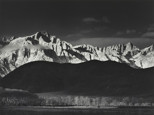
Winter Sunrise, Sierra Nevada, by Ansel Adams

Winter Sunrise, Sierra Nevada, by Ansel Adams

Arrayed on the left-hand hillside of the Alabama Hills were the large letters LP spelled out in white-washed rocks that stood for Lone Pine. Driving through the town, you can still see the letters, which are refurbished by locals in a ritual familiar to many communities in the Western states. Ansel Adams was so disturbed by what he considered to be an ugly scar in the landscape that he spot-toned out the letters in his prints with a small brush, and in the 1970s finally had them eliminated from the negative itself by his assistant.

– William Fox, Camera Obscura: A photographic history of the LA Aqueduct, in Boom

Stuff I wrote elsewhere: the flood that wasn’t

There’s a newsroom joke that “we don’t write about planes that don’t crash,” but I think it’s important to think carefully about societal systems that succeed, because lessons learned matter:

The flood pulse was impressive. But it is instructive to look at how much larger it would have been if not for a pair of flood control dams built in the second half of the 20th century to protect us from our habit of building our cities in flood plains. On Sept. 13, they were two dams in the right places at the right time.

Importantly, one of the lessons is that there are always tradeoffs. Flood control success did not come without cost:

Authorized by Congress in 1960 and completed in the mid-’70s, Cochiti is one of the largest and arguably the most controversial dam in New Mexico. Its completion drowned farmlands, summer homes and culturally significant sites at Cochiti Pueblo, and seepage beneath the dam waterlogged remaining pueblo farmlands downstream. In addition, the way it altered the Rio Grande’s flows has caused lasting environmental problems downstream, depriving the riverside ecosystem of natural floods.

But on Sept. 13, it did the job we gave it when we built it, which was to protect the Middle Rio Grande Valley from flooding.

Pat Mulroy retiring

Here’s Henry Brean:

Long-time Southern Nevada Water Authority chief Pat Mulroy is preparing to retire but won’t make a formal announcement until “she’s ready,” Clark County Commissioner Steve Sisolak said Monday.

And Conor Shine:

Southern Nevada Water Authority General Manager Pat Mulroy is planning to retire after 22 years on the job.

Reached Monday evening, Mulroy said she had not set a date for her departure and was instead working to prepare an “orderly transition.”

“I think it’s time to have that discussion about ‘Where do we go from here?’” Mulroy said. “I have not set a date. It will be when all of that is teed up.”

This totally screws up the last chapter of my book.

California groundwater: bring on the social scientists

Writing in Science four years ago, the late Elinor Ostrom outlined a number of characteristics of necessary for sustainable development and use of what’s called in the literature “social-ecological systems”. These are complexes of humans and resources where the success of each depends on the interplay with the other, like forests and fisheries and, for purposes of today’s topic, groundwater.

Elinor Ostrom

Elinor Ostrom, courtesy Wikipedia

Ostrom’s genius lay in the way she grasped the need to generalize from the welter of specific cases of groups of humans succeeding or failing at the task of sustaining community-resource interactions in situations where there is a risk of irreparably depleting a resource on which your community depends. Her doctoral thesis dove deep into one such case, in which a group of communities in coastal Southern California banded together to develop the necessary institutions to avoid overpumping their aquifer. But that was just one case. By the end of her career, she’d been at the forefront of the search for a set of general principles.

I was reminded of this as I read Jay Famiglietti’s op-ed in this morning’s Los Angeles Times about California’s groundwater depletion race to the bottom:

In the Central Valley, falling well levels and subsiding land are curtailing food production, damaging ecosystems and threatening the livelihoods of the thousands of area residents employed by the water-dependent agricultural sector. A recent report on the Coachella Valley documented decades of groundwater depletion there as well, despite local and regional efforts at managed recharge and water banking.

Clearly, this is a problem. And yet it doesn’t happen everywhere. Ostrom’s Southern California case studies show examples of communities that long ago built the necessary social infrastructure to master their groundwater overpumping problems. My question for the social scientists in the room: What’s the difference?


Stuff I wrote elsewhere: the Rio’s smell

From the work blog:

Corky Herkenhoff, who’s been farming at San Acacia for half a century, told me he can tell where the runoff is coming from by the smell. San Acacia sits just below the Rio Puerco and Rio Salado, two generally dry tributaries that have been pumping water into the Rio Grande over the last week. Herkenhoff said he can tell the difference. “You can tell when the Rio Puerco comes in, and you can tell when the Rio Salado comes in,” he said.

Muddy river

Swirls as the muddy Rio Grande passed through Albuquerque this morning:

Muddy Rio Grande, John Fleck, 9/15/2013

Muddy Rio Grande, John Fleck, 9/15/2013

(Much electronic manipulation of the image to bring out those colors. It was pretty, but not quite that pretty.)

Chasing water in the desert: the great Rio Grande “flood” of 2013

In the midst of a very unusual storm (see my newspaper explanation of its unusualness here), I’ve spent much of the last 24 hours watching a big slug of water make its way down the Rio Grande Valley in which Albuquerque sits. A source yesterday afternoon pointed me to the readings on the USGS San Felipe gauge, which had popped up over 9,000 cubic feet per second. For this spot on this river, upstream from Albuquerque, that is a lot of water. We quickly committed journalism, the water managers rallied their modelers and calculated estimated peak flows and arrival times, the municipal authorities went into hyperdrive. And then we waited.

This was not a “wall of water” type of flow, but as modeled, it was likely to be up near the largest flow we’ve had in Albuquerque in the post-dam era. So we staked out the bridges, as did a hoard horde of residents, to watch our briefly big river roll past. (My colleague Rob Browman illustrated this part nicely.)

After work, Lissa and I went out in the pitch dark so she could see it, and then I spent today following the pig in the python downstream. It’s a slow-moving, easy-to-track thing: midnight at Albuquerque’s Central Avenue bridge, noon today at Los Lunas south of here, rising as I write this at Bosque, the gauge in the far southern end of Valencia County.

The thing that was hard to capture was the quiet nature of the event. We think of “floods” as tempestuous, but as I wrote this morning, one of the reasons the flow was less than expected is the way the river spread gently into the woods alongside its main channel. Upstream, the river has been incising into its old flood plain, so the spreading is only possible in places where human intervention, in the form of habitat restoration, has created low areas, swales and side channels for endangered critters. To the south, the river made it out of its banks on its own.

I am not a photojournalist, but I’m trying to learn how to take pictures that tell stories. Here’s one attempt, a cottonwood in a normally dry bosque forest with a soft blanket of water at its feet:
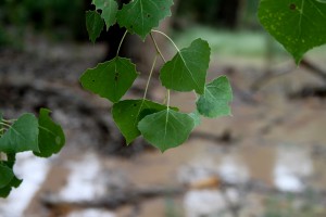
Quiet water in the cottonwood bosque, John Fleck, 9/14/2013

Quiet water in the cottonwood bosque, John Fleck, 9/14/2013