Famiglietti on GRACE and the need for good groundwater data

Data from the German-NASA GRACE satellites highlights groundwater depletion hotspots in the United States. CREDIT: CAROLINE DE LINAGE/UNIV. OF CALIFORNIA, IRVINE, Science magazine

Data from the German-NASA GRACE satellites highlights groundwater depletion hotspots in the United States. CREDIT: CAROLINE DE LINAGE/UNIV. OF CALIFORNIA, IRVINE, Science magazine

Jay Famiglietti, from UC Irvine in California, and his colleagues have made something of a scientific cottage industry out of the use of data from the German-NASA GRACE satellites (short for Gravity Recovery and Climate Experiment) to measure changes in groundwater around the world. Not surprisingly, it’s going down as humans pump it out to use faster than the globe’s hydrologic system can put it back. The GRACE numbers have substantially improved our understanding of this problem (see, for example, India, California’s Central Valley, the Tigris-Euphrates basins). “GRACE may be the only hope for groundwater depletion assessments in data-poor regions of the world,” they wrote in 2007.

But there are problems, as Famiglietti and Matthew Rodell write in this week’s Science (link might be behind Science’s paywall). GRACE was launched in 2002 with a five-year nominal lifetime, which it has obviously exceeded. A follow-on is not planned to launch until 2017:

For GRACE and its successors to maximize their value for water management, key issues must be addressed. First, the current 2- to 6-month latency before GRACE data are released must be substantially reduced to enable their use in seasonal prediction. Second, GRACE data should be better integrated into the modeling and decision support systems used by operational water management centers. Finally, next-generation missions beyond GRACE-FO should aim to achieve higher spatial (<50,000 km2) and temporal (weekly or biweekly) resolution, for example through novel orbital configurations, so that smaller river basins and aquifers can be observed directly. The availability of GRACE data at these finer scales, at which most planning decisions are made, would likely ensure their broader use in water management.

NASA’s Fiscal Year 2014 budget (big pdf) $83.4 million for work on the GRACE follow-on mission. Preliminary estimate puts the total life cycle cost at $404m to $460m. I don’t follow NASA closely, or understand its budget dynamics, so I’ve no idea if that’s a reasonable number, or what the tradeoffs are in terms of other programs struggling for funding in the Commerce, Justice, Science and Related Agencies appropriations bills in which NASA has to compete.


River Beat: June numbers show slight improvement in Lake Powell

Lake Powell, the large Upper Colorado River Basin Reservoir sitting behind Glen Canyon Dam, ended May with a surface elevation of 3,599.44 feet above sea level, 3 feet higher than projected a month ago, thanks to greater-than-anticipated runoff during the month. Some of that’s just time-shifting – an early melt bringing water down sooner than expected. But the U.S. Bureau of Reclamation’s new 24-Month Study (pdf) shows some slight improvement, estimating the end-of-September water levels to be slightly higher in Lake Powell than the agency projected in last month’s analysis.

That’s the good news. Here’s the bad news. As I wrote last Thursday, the new 24-Month-Study seems to suggest increasing probability of a shortage declaration on the Colorado River by 2015, instead of 2016, as officials had indicated last month. I’ve extended my little reservoir storage graph to include estimated storage to the end of the 2014 water year, and while the end of 2013 shows a slight improvement over last month, you can see that total Mead-Powell storage is projected to be, by next year, at its lowest levels since Lake Powell was first filled in the 1960s:

Total Projected Storage, Lakes Mead and Powell, June 2013

Total Projected Storage, Lakes Mead and Powell, June 2013

Dianne Feinstein has a bunch of #cawater ideas

In an op-ed in today’s Sacramento Bee, Sen. Dianne Feinstein, D-CA, has a lot of ideas for fixing California’s water problems:

  • bigger dams
  • tweaks (unspecified) to the Endangered Species Act
  • a Peripheral Tunnel (do we still call it “Peripheral”?) to ease conveyance of water from north to south of the water Californians will be storing behind their new, larger dams
  • a giant statewide water bond to pay for stuff, but not too big! or the voters might not approve it

Notably absent from her list: using less water.

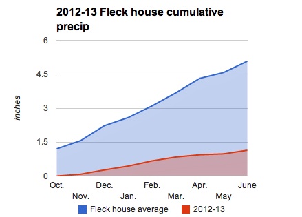
2012-13 precip reaches single digits

With 0.02 inch (0.5 mm) of rain yesterday afternoon, we’ve finally hit 1 inch (25 mm) at our house for the 2012-13 (Oct.-Sept.) water year.

Then it rained again this afternoon, making this the first time we’ve had consecutive days with measurable precipitation since Dec. 15-16. Through the end of May, we’re at 21 percent of my long term mean for this point in the water year:

2012-13 Heineman-Fleck house water year

2012-13 Heineman-Fleck house water year

Colorado River shortage declaration possible by 2015/16

update: Michael Cohen at the Pacific Institute emailed with a subtle clarification. If Lake Mead, as the USBR analysis reported below suggests, drops below elevation 1,075 feet above sea level during 2015, the actual shortage declaration on the lower Colorado would then apply to the following year’s water allocation. More specifically, during August the Bureau looks at the projected Jan. 1 storage, and if that’s below 1,075, the shortage is declared. Historically, about half the time Lake Mead has been lower Jan. 1 than the May number.  This means we could have the shortage declaration in 2015, but the actual shortage wouldn’t kick in until calendar year 2016. Correction appended below.

previously: There was a round of press coverage last month (including from me) when Mike Connor, head of the U.S. Bureau of Reclamation, told reporters that internal Bureau modeling suggested as much as a one-in-three chance that Lake Mead would drop so low by 2016 that the federal government would make the first ever formal shortage declaration on the Colorado River.

Boulder Harbor, Lake Mead, Oct. 18, 2010

Boulder Harbor, Lake Mead, Oct. 18, 2010

New data out yesterday suggests that may have been too optimistic. The latest operational report from the Bureau now suggests a good chance of hitting the shortage trigger by mid-2015.   Arizona and Nevada take the hit, and it’s a small hit initially, but it grows as Mead drops further.

The latest monthly modeling report (the Bureau’s much-read 24-Month Study) now suggests Lake Mead’s surface elevation could drop to 1,075 feet above sea level – the level at which a formal shortage declaration is required – as early as June 2015. As I understand the rules, this would likely could mean a reduction in water deliveries (initially, a small reduction) beginning in the fall of 2015 calendar year 2016.

Actually, it doesn’t exactly say we’ll be under 1075 in June 2015. The 24th month of the study (remember the name – it’s a 24-Month Study) is May 2015, at which point the Bureau figures Lake Mead’s elevation will sit at 1,075.28 feet above sea level. That’s 3 inches – the wake of a slow boat – above the drought trigger. But given that Lake Mead’s always dropping at that time of year, one can reasonably project that, if reality follows the trajectory of these projections, it’ll be below 1075 come June 2015 – a year earlier than the model runs Connor mentioned to reporters just a month ago.

So what’s different?

The answer, I’m told by Bureau staff, is a change in the approach to modeling the supply side for the out years in the study. In the near term, for the current year, the Bureau uses forecast model data from NOAA’s Colorado Basin River Forecast Center. For the latter part of the 24-month window, the Bureau would then just plug in average month-by-month data, essentially presuming the out-year periods were “normal”.

But starting this month, the Bureau switched to the use numbers from one of the CBRFC’s long-range forecast models, which seems to be much more pessimistic than the old “normals” used in the May 24-Month Study. The modeling switch, combined with some water management spare change (differences in Grand Canyon inflows, a change in the Metropolitan Water District’s operating plans) has resulted in a ginormous 2 million acre foot drop in total storage in Lakes Mead and Powell in mid-2015 between the May and June 24-Month Studies.

My picture, above, was taken in October 2010, when Lake Mead was in the low 1080s.

Dear tourists: many areas of New Mexico are currently not on fire

The city government folks in Santa Fe, NM, want to assure you that, despite all the smoke, Santa Fe itself is currently not on fire:

A news release issued by city government on Wednesday declared that “forest fires burning in Northern New Mexico are well removed from the City of Santa Fe and are not disrupting the city’s busy summer schedule.”

The fires “that you might have seen on the news” are more than 20 miles from city limits and haven’t affected a planned summer tourism season of art markets, opera performances and other events, the statement said.

To check if your vacation destination is currently on fire, I recommend Inciweb.

“City Water, City Life”

a pond and a dog

a pond and a dog

I live in a suburban neighborhood that dates to the early 1950s, when this swath of mesa east of the Rio Grande was cleared for homes. It’s almost certainly at that point that the city of Albuquerque, which then managed the water utility, laid a grid of pipes to bring water to the area.

Carl Smith, in his new book City Water, City Life, talks about the importance of that gridding in the evolution of American urban life:

To be reliant on a network of water pipes defined more viscerally than did walking or riding through streets the condition of being “on the grid,” that is, within a human-made world separate from nature. Given how radical the shift was from fetching water from a natural source to taking it from a tap, it is remarkable how quickly city people came to view the new state of things as normal and, for lack of a better word, natural.

I came along long after that moment in history, but I can easily grasp what Smith lays out as a corollary.

Down in the bosque, the riverside woods that flank the Rio Grande here in Albuquerque, is a pond built by federal wildlife folks to stand in for habitat lost when the river was pinned by dams and levees. It’s one of my favorite “natural” spots to go for a walk. Here’s Smith:

Meanwhile, the American nation’s presumed identification with nature, as well as the timeless concern with the dehumanizing tendencies of urban life, drove efforts to protect or restore the presence of the natural world in the city, even if that presence was nearly as fabricated as the grid.

Sound about right to me.

“This is a different river.”

I write about minnows in the Rio Grande, and smelt and salmon in the Sacramento-San Joaquin Delta. Richard White writes about salmon in the Columbia.

In all three cases, we’re discussing species-focused environmental efforts – to “save” the silvery minnow in the Rio Grande, or salmon and the delta smelt in California, or salmon in the Columbia. White, in his I-highly-recommend-it book “The Organic Machine”, makes a point that applies to all three situations. We’re fixated on species, but in a river system that’s been heavily remodeled:

If this were the old Columbia River System there should be salmon, but this is a different river. It is not the river salmon evolved in.

On Twitter this morning, southern New Mexico journalist Heath Haussamen commented on the water currently flowing through his community:

water in the desert, 21st century style

water in the desert, 21st century style

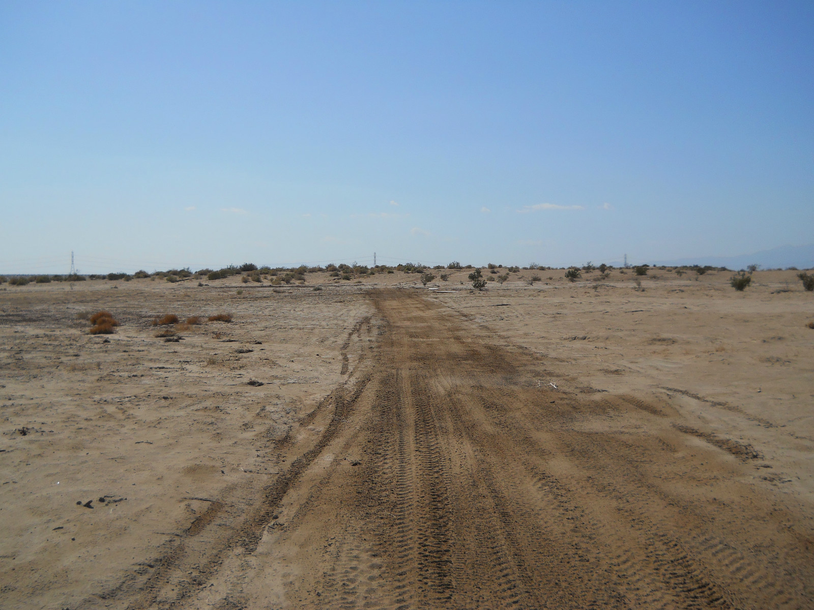
That irrigation canal is the Rio Grande.