Deadpool Diaries: “Nice river basin ya’ got there….”

Wrecked speedboat on the shore of a reservoir.

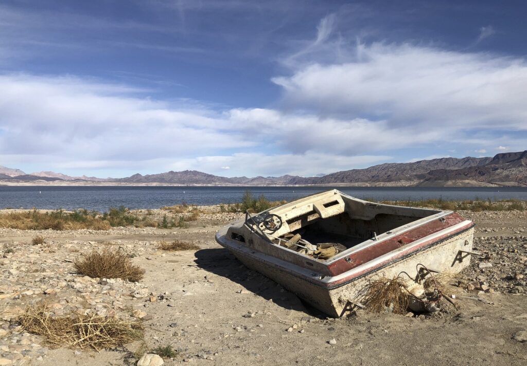
Nice boat ya got there, would be a shame if somethin’ happened to it.

This feels like a shakedown.

Nice river basin ya’ got there. Would be shame if somethin’ happened to it.

For decades, Lower Colorado River water users have been taking more water than the river can provide, threatening their own communities’ futures. Unable to come up with a plan to live within their water means, they’re now asking us to pay them to not crash the system on which we all depend.

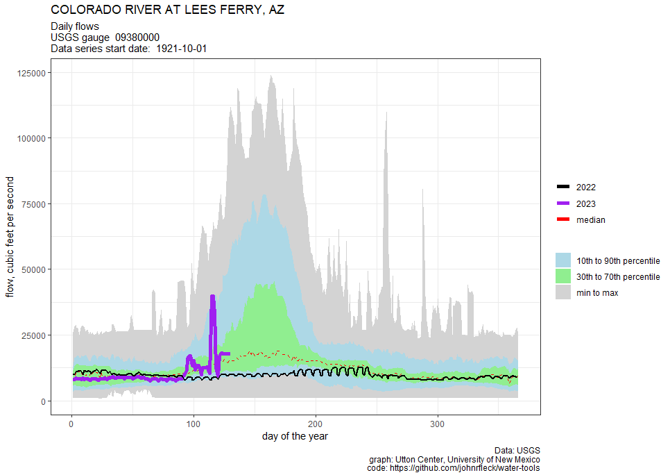
The shakedown comes in the form of a letter this morning from California, Arizona, and Nevada to the Department of Interior laying out an agreement that would (as near as I can tell, the letter is light on details) reduce water use in the Lower Basin by 3 million acre feet above and beyond already agred-upon cuts (the 2007 Guidelines and Drought Contingency Plan) between now and 2026, with the bulk of those reductions to be compensated with federal money.

Some good things in the proposal

I’ve been putting off reporters today, saying I didn’t want to comment without seeing more detail on the proposal’s water numbers. I stand by that hesitancy. It’s hard to know if the cuts will be enough to accomplish what needs to be accomplished. But there’s some language that is encouraging.

First, the proposal includes a helpful “what if” – if the hydrology is bad and the cuts aren’t enough, the states will come up with “an implementable plan” to keep Mead above elevation 1,000. “If such an acceptable plan, as determined by Reclamation, is not developed, Reclamation may independently take action(s) to protect 1,000 feet.”

But I hope you can see the weirdness here. “If we can’t figure out how to save ourselves from our overuse of water, we give Reclamation permission to save us.”

Second, if the hydrology is bad enough to risk dropping Powell below elevation 3,500, the states are cool with Reclamation dropping releases from Powell as low as 6 million acre feet. Sorta. “If we can’t figure out how to reduce our use enough to save Glen Canyon Dam, we give Reclamation permission to go ahead and save it anyway.”

Other People’s Money, Other People’s Values

In the fall class Bob Berrens and I teach in the University of New Mexico’s Water Resources Program, we have a common refrain in discussion of the students’ suggestions for dealing with water shortfalls: “That sounds like a great idea, how are you going to pay for it?” The answer is invariably state or federal money  – “other people’s money”, not the money of the community benefitting from the use of the water and suffering the consequences of shortages.

We spend a lot of time talking about the tradeoff. When you take other people’s money, you also have to accept other people’s values.

Here’s the pertinent language from today’s letter from California, Arizona, and Nevada:

System Conservation up to 2.3 MAF will be federally compensated under Pub. L. 117-169 Inflation Reduction Act Title V, Subtitle B, Part 3 “Drought Response and Preparedness” Section 50233 “Drought Mitigation in the Reclamation States” (IRA Funding).

There seems to be $1.2 billion of that IRA money on the table here, according to the New York Times story.

That’s the shakedown. If you don’t pay us a big pile of federal cash, we’ll just run Lake Mead to deadpool. Or, alternatively, if you don’t pay us a big pile of federal cash, we’ll drag the Colorado River Basin into litigation that will make the river ungovernable, a sort of institutional deadpool. Either way, it’s a shakedown.

There’s nothing here that is any sort of a nod to what we might expect from the Lower Basin in return for our largesse other than, “If you pay us, we won’t crash the thing.”

The Dangerous Precedent

I am sympathetic to the water users whose entitlements were ensured under Article VIII of the Colorado River Compact: “Present perfected rights to the beneficial use of waters of the Colorado River System are unimpaired by this compact.

This is an important protection for Tribal water rights, and also some of the big ag districts. Great! Let the Lower Basin’s junior users work out a deal with the pre-compact rights holders to move that water around. Let’s see a QSA for Arizona. Let’s see QSA II for California. Show us your plan to live within your means, other than “Pay us to live within our means.”

The approach in the Lower Basin states letter – have the federal taxpayers pick up the tab rather than the people who’ve created the mess – sets a dangerous precedent for our approach in the post-2026 Colorado River management world.


The Stotts Lateral: new candidate for “Albuquerque’s Most Urban Ditch”

Graffiti-lined irrigation ditch corridor with bicycle.

The Stotts Lateral, off the 6100 block of North Second, Albuquerque, New Mexico. May 2023

My search for Albuquerque’s “Most Urban Irrigation Ditch” took us yesterday to the Stotts Lateral in the North Valley. The Stotts is about a half mile long, carrying water under the railroad tracks from the Alameda Lateral to the Alameda Drain. The east half is underground. The west half, tiny and concrete-lined, is an urban art gallery.

I’d been there before on one of those “never quite lost but I’ve no idea where I am” bike rides. We’d come in from the back side on one of our searches for safe places to cross the railroad tracks, and I knew it was wonderful and a good place to cross the tracks, but I couldn’t remember quite where it was.

The railroad corridor through Albuquerque’s North Valley matters a great deal for the new book Bob Berrens and I are writing, because you can’t make sense of the evolution of Albuquerque’s relationship with the Rio Grande without understanding the way the construction of the railroad in 1880 changed the community’s relationship with the river by changing where we were and what we were doing there.

Our story is thus about the tension between old rural subsistence ways and urbanity/modernity.

On this stretch of Second we’ve got a weirdly lovely little irrigation ditch slipping between Acme Iron and Metal (“the largest scrap metal recycler in New Mexico”) and an aging min-storage lot.

The graffiti along the railroad corridor is, in general, one of Albuquerque’s great art collections. The Stotts Lateral is one of the collection’s great gallery spaces.

I’m pushing our “gardening” metaphor to the breaking point when I say this, but as Scot and I rode down the Stotts yesterday, there was a guy with a spray can in one hand talking on a cell phone in the other, painting a magnificent huge tag. The sweep of his arm, the line confidence as he sprayed almost casually while talking, was like a slow graceful dance.

He was tending this particular garden.

I wonder who Stotts was?


Yes, Cochiti Dam is really five miles long

OK, 4.75 miles. I rounded up.

A skeptical blog commenter suggested I was exaggerating the size of Cochiti Dam.

I was not.

Last year, on a bike ride to explore the area I am writing about for the new book, I rode NM16 up out of the Rio Grande Valley and around the dam’s southeastern flank to get a view of the dogleg at the dam’s southeastern end where it hooks around to dam the Rio Santa Fe. Mostly I ride for fun, but I ride the landscape I’m writing about to get a visceral feel for the subject, and riding around the base of the dam gave me a feel for the scale. But I did go to the maps to measure after I got back from the ride.

The size is variously estimated at 5, 5.25, or 5.5 miles, I think depending of how much of the anchoring work on either end you count. It has been characterized (at 5.5 miles) as “the longest dam in the United States“, though I haven’t done the work to verify that.

The size was an object of enthusiastic marvel (by some) when as it was being built. In a June 1973 “Discover New Mexico” article, the Santa Fe New Mexican gushed about the chance to see the construction underway – the spectacle of the construction of a five mile long earthen dam:

Anyone who fails to drive out to the observation point above the dam-sit, where he can watch construction operations and see the harnessing of the sometimes turbulent, often lazy, Rio Grande, diminishes his knowledge of the Land of Enchantment….

The observation point boasts a comfort station, ample parking space, and a vantage point for watching ant-like objects crawling the length of the earthfill dam. All five miles of it. (emphasis added)

Though, as this morning’s blog post pointed out, the enthusiasm for the dam’s grandeur as it was being built was not shared by the people of Cochiti, on whose land it was built and whose sacred sites it destroyed. No mention of that in the 1973 article.

On Cochiti dam and the notion of “flooding”

Submerged swimming dock in a reservoir with a gorgeous New Mexico sky behind it.

When you hold water behind a flood control dam to protect stuff downstream from flooding, and it inundates a swimming beach, is that a “flood”? Cochiti Dam, May 2023, photo by John Fleck

Rio Grande flow dropped this week through Albuquerque, at a time when we should expect it to be rising with the accelerating melt of an unusually large snowmelt.

What’s up with that?

The answer (see below, I’m can’t figure out how to tl;dr this) is a case study in the stuff we’re trying to explain in our new book.

Otowi, Cochiti

Orange graph on white background showing Rio Grande rising over the last month at Otowi.

A rising Rio Grande.

Upstream at Otowi, as the Rio Grande enters the last narrow canyon before it hits the Albuquerque reach of the river, what we call the “Middle Rio Grande Valley”, the river is rising.

But between Otowi and us, there’s a big dam at a place called Cochiti.

“Big dam” doesn’t fully capture its bigness. I can still remember the visceral reaction when I was wandering the area around the dam’s eastern flank last year and found a vantage point where I could see the whole thing. The crest of Cochiti Dam is five miles long. It dams not one but two rivers, the Rio Grande and the Rio Santa Fe.

The cultural damage its construction caused to the people of Cochiti Pueblo, the Native American  community whose land the dam’s construction slashed through when it was built in the 1960s and ’70s, is incalculably larger.

Here are the words of Cochiti’s Regis Pecos:

To see this construction proceed before our eyes; sacred space and place defined by all those who had gone before violated before our eyes was very hurtful. Unimaginable pain. It was piercing the hearts of our people daily. One of the most emotional periods in our history was watching our ancestors torn from their resting places, removed during excavation. The places of worship were dynamited, destroyed, and desecrated by the construction. The traditional homelands were destroyed. When the flood gates closed and waters filled Cochiti Lake, to see the devastation to all of the agricultural land upon which we had walked and had learned the lessons of life from our grandfathers destroyed before our yes was like the world was coming to an end.

A brief history of the idea of a dam at Cochiti

For the new book (Fleck and Berrens, Ribbons of Green: The Rio Grande and the Making of a Modern American City, to be published by the University of New Mexico Press once Bob and I figure out how to write it), I’ve been working on a chapter about … well, I’m not sure exactly what it’s about yet, which is why I’m working here in the sketchbook.

The first mention of a dam in White Rock Canyon seems to have come from John Wesley Powell in an 1890 report to Congress. The arrival of the railroad in central New Mexico had happened 10 years before, and Albuquerque was beginning to claw its way into modernity when Powell said this:

The canyon walls are hundreds of feet, and in some cases more than a thousand feet, above the waters. White Rock Canyon empties below into a valley which I shall call the Albuquerque Valley. In it lie Bernalillo, Albuquerque, Los Lunas, Socorro, and other towns. Now, all the water that comes out of White Rock Canyon can be used in the Albuquerque Valley. Whoever has control of that point owns that dam site and has the right to take the water out of its natural channel and carry it into canals – has command of all the agriculture of that great district.

“Whoever has control of that point” – that phrase jumped at me off the page, angrily demanding to be admitted to the pages of our book. “Whoever has control of that point….” Because from time immemorial, that point has been a part of Cochiti.

By the 1930s, “Whoever has control of that point….” was the Middle Rio Grande Conservancy District, which built a low irrigation diversion dam – it didn’t impound water or slow flood waters, just created a stable surface for an irrigation head gate.

By the 1960s, “Whoever has control of that point….” was passed to the U.S. Army Corps of Engineers, which built the huge dam that looms over Cochiti Pueblo today.

The notion of “flood control”

I’m rolling all of this around because of two things. The first is some remarkable Congressional testimony from Jose Alcario Montoya, Cochiti’s governor, to members of Congress in 1943 when they were considering construction of a flood control dam to protect Albuquerque. Here’s how I’m excerpting it for the book:

“And so I have heard yesterday here that we are in very great danger from flood and that we are losing land,” said Montoya, whose community sits at the valley’s upstream end 75 miles above Albuquerque. “I do not think it is so that we have lost any land.”

“Suppose the land is on one side of the river and the river cuts over and cuts part of that land away. While it is doing that it is making new land on the other side and so we never lose any. When the river gets down, we use that land again for cultivation.”

The second was a conversation with the person working the entrance booth at Cochiti Lake.

Pooled behind the dam, a modest “recreation pool” allows swimming and no-wake boating. But the booth person explained when I visited that the swimming beach was closed “because of the flood”.

This use of the word was weird.

The reason Cochiti Lake is rising, and the flows downstream of the dam have been reduced, is a decision by water managers to throttle back flows to protect a bridge culvert downstream, in Los Lunas, New Mexico. Last Saturday night, the culvert collapse and swallowed up a bicyclist. (He’s beat up, but OK.)

The Oxford English Dictionary’s fourth definition for flood kinda matches the sense being used for the closure of the Cochiti swimming beach: “An overflowing or irruption of a great body of water over land not usually submerged.”

The point Montoya was making was that if you let a river move around, and then move with it, “flooding” is not a thing that happens. But as soon as we built a city in the place where a river would naturally go during high spring flows, you create “flooding” where in the past it would simply have been a river doing its normal river things.

So you build bridges, and culverts, and a big dam upstream to contain “floods”. Instead of a river’s natural bed, we name it the “flood plain”, which naturally spilled out of my keyboard a few paragraphs ago without me even realizing the semiotic baggage the phrase carried. (See scare quotes.)

And you build a flood control dam. And then you build a swimming beach, and then when the water behind the flood control dam starts to rise because you are trying to protect a bridge culvert in Los Lunas, and inundates the beach, you call that a “flood”.

Sorry this was so long, I didn’t have time to write a shorter blog post. I’ll tighten it up for the book.


Deadpool Diaries: Colorado River Report Card, May 2023 – please tell us your plan

Graph showing increased flow this year on the Colorado River at Lees Ferry gauge

The Bureau of Reclamation is currently blasting water out the bottom of Glen Canyon Dam as Lake Powell rises with this year’s big snowmelt.

(The big spike is an experimental flow pulse.)

Lake Mead, as a result, is rising for the first time in a while, with the wrecked speedboats disappearing – and with it, the apparent sense of urgency about cutting our water use.

Downstream the big ag districts and municipalities are taking advantage of the wet year to put off decisions about how, in the long term, to bring water use into balance with available supply.

The Lower Basin Structural Deficit, Circa 2023

The classic Reclamation “structural deficit” slide put the gap between available water and use when the Upper Basin meets its legal delivery requirement, and folks in the Lower Basin take their full allotment, at 1.2 million acre feet per year.

Under the latest official Reclamation forecast, the Lower Basin states are reducing their use by 756,000 acre feet below their nominal 7.5 million acre foot allotments. Yay for using less water! But it still falls short of the 1.2 million acre feet needed to close the structural deficit, and is far less than the amount that might be needed to refill a bit, to provide a safety cushion against a run of bad years. The only reason Lake Mead is projected to rise this year is thanks to a big snowpack and a bunch of resulting bonus water from the Upper Basin.

Here are the numbers, with officially forecast 2023 use in millions of acre feet as of May 10, 2023

2023        pct
California 4.196 95.4%
Arizona 2.334 83.4%
Nevada 0.214 71.3%


In other words, the pattern of Lower Basin water users putting off hard decisions about reducing their use, depending instead on Upper Basin bonus water, continues. (See “Hookers and Blow on the Lower Colorado River” – this has been going on a while.)

It is possible that Lower Basin use is gonna drop more this year than the official forecast suggests, that the current 5up3r 53cr3t talking now underway will yield more water use reductions. I keep hearing that. I keep not seeing it in the official numbers.

Upper Basin Water Use Reduction Efforts

According to the Denver Post’s Conrad Swanson, quoting the Upper Basin’s Chuck Cullom, the Upper Basin’s system conservation program hasn’t come up with much water either

If each of the program’s approved applications works out as expected the upper-basin can expect to save about 39,000 acre-feet at a cost of about $16 million, Cullom said.

Please tell us your plan

That’s it. That’s my ask of the Colorado River Basin leadership community.

Tell us your plan.

Inkstain will always be free, and is reader supported.

Dust on snow seems to be increasing the chances of Rio Grande drying this year through Albuquerque

Water flowing over a bicycle trail with a river in the background

Rio Grande overbanking May 3, 2023 finally topped my little bike trail north of Albuquerque’s Central Avenue Bridge. ~4k cubic feet per second.

We have a chance this year to watch a fascinating intersection of climate-change driven changes in the Rio Grande through Albuquerque as filtered through both physical infrastructure and what we call the “institutional hydrograph”.

The tl;dr

Dust on snow is likely to accelerate Rio Grande headwaters snowmelt, meaning all that stored water comes off earlier. With nowhere to store it (see below, it’s an issue of both rules and physical infrastructure problems), we’ll be operating this year in a run-of-the-river situation on the middle Rio Grande through Albuquerque. Even though there’s still a lot of snow right now, once it comes off we’ll be down to base flow on the Rio Grande. Absent good summer rains, the river could dry through Albuquerque again this year.

Dust on Snow

The driver is a phenomenon researchers have identified in the past two decades called “dust on snow“. It’s when dry spring winds sweep across the arid uplands of, in our case, the Colorado Plateau, kicking up a layer or layers of dust that is then deposited atop the mountain snows in the high country. You can get multiple dust  layers, and when the melt reaches them, the snow warms up and melts quicker. There’s a climate change connection to all of this, as hotter, drier springs seem to lead to more dust (which makes intuitive sense, and is discussed in Painter, Thomas H. et al. “Response of Colorado River runoff to dust radiative forcing in snow.” Proceedings of the National Academy of Sciences 107 (2010): 17125 – 17130.

We’ve got that going on this year in the Rio Grande headwaters. From this morning’s Downtown Albuquerque News:

April’s dry and windy conditions have deposited a lot of dust in the Rio Grande headwaters, so the snow will be generally less reflective and absorb more heat. That, in turn, “means runoff will likely be advanced, leaving less for the later summer months,” reported Angus Goodbody, a Natural Resources Conservation Service hydrologist.

The Physical Plumbing: El Vado Dam

In the “before times” (before the creation of the Middle Rio Grande Conservancy District in the early 20th century, which led to the construction of El Vado Dam) communities in New Mexico’s Middle Rio Grande depended on the run of the river. When the runoff dwindled in the summer, they couldn’t irrigate. (This is part of the reasoning behind our argument in the new book that claims that there once were ~125,000 acres irrigated in the Middle Valley are not credible.) Construction of El Vado allowed communities to do the classic “dams move water in time” thing – store some of the big spring peak and stretch it out through summer.

El Vado is busted, though, unusable while it undergoes repairs. As Dani Prokop reported last month, the repairs are dragging:

The dam’s unique steel faceplate is causing challenges for the contractors and storing water in 2024 is impossible, said Jennifer Faler, the area manager at the Bureau of Reclamation office in Albuquerque. Faler said the dam will possibly store some water in 2025, when another phase of construction on a spillway is underway.

That means no storage (other than a little bit in Abiquiu Reservoir for Native American communities) for irrigators, which means that once the snow is melted, the river will dwindle.

The Institutional Plumbing: Article VI

Even if El Vado wasn’t broken, though, we’d sorta be in the same bind thanks to Article VI of the Rio Grande compact, which says….

Within the physical limitations of storage capacity in such reservoirs, New Mexico shall retain water in storage at all times to the extent of its
accrued debit.

New Mexico’s compact debt to Texas – the net we’ve underdelivered in recent years – is 93,000 acre feet. So even if El Vado wasn’t broken, any water we were able to store up to 93,000 acre feet would have to stay there. (This is why the Middle Rio Grande Conservancy District has reduced its diversions this year to 80 percent of what the district otherwise be sending down its canals – to get more of that water to Elephant Butte Reservoir, to try to reduce compact debt, so they can usefully store water once El Vado is fixed. This is a whole other blog post, because the discourse around this has been fascinating as I do the “embedded writer” thing at MRGCD for my book research.)

Hydrology in the 21st century: understanding the rules

I was down at the Rio Grande yesterday morning to record an interview about western water stuff with a crew from Italian public television. (The were neat! It was fun!) A bosque walker asked what we were doing and Luca, the TV guy, explained that they were interviewing the professor (pointing to me). The woman asked if I was a hydrologist. No, I replied, I do water policy.

That’s the thing. To understand the flow in the river we were standing next to, you need to understand the physical science – climate, hydrology, and such. But then, crucially, you needs to think about how the actual wet water is filter through the system’s human-built physical plumbing, which then requires understanding who it all is filtered through the rules.

A note on sources, methods, and business models

At this point in a post like this, I often drop in a thanks to my supporters, who make this work possible, including the Utton Center and Inkstain’s contributors. But I’d also point you to the linked information sources above – Downtown Albuquerque News is subscription-supported and one of my favorite local news reads, and Source NM (Dani Prokop’s employer – she’s doing great water stuff, invaluable to the community). Information is a public good, and as my economist friends like to point out, because of the free rider problem, public goods are under-provided.

Stansbury puts pressure on the Air Force to deal with the Kirtland Air Force Base spill

Rep. Melanie Stansbury, my congresswoman, is throwing her considerable political and water policy clout behind efforts to poke the U.S. Air Force into action on its malingering fuel spill on Albuquerque’s south side. Dani Prokop had a nice overview of the issues this morning in Source NM:

Rep. Melanie Stansbury (D-N.M.) called Tuesday for the Air Force to “quickly and decisively” act on the spill.

“Our communities deserve action, transparency, and collaboration from Air Force leadership, and I will be working to ensure the Air Force is responsive to the needs of our community,” she said in an emailed statement.

The details of the current dispute between the New Mexico Environment Department and the Air Force are a bit arcane, involving an argument over the adequacy of the Air Force’s sampling plans for the site. But the deeper issue remains a lack of progress on a significant threat to our groundwater that has been lingering for far too long.

If we can’t get the sampling right, how are we going to clean it up?


Ribbons of green and the sand hills beyond

Roadway with parked cars, power lines, and downtown Albuquerque buildings in the distance

If you squint you can see the ribbons of green between the power poles and buildings of downtown Albuquerque

There’s a weird bench at the edge of a lovely little ten acre patch of desert sand hill scrub a ten minute walk from my office at the UNM School of Law.

The path circles the edge of the university’s north golf course, which is green and lovely in its pumped-groundwater way. The path (It’s a formal county recreational path, there are even signs!) cuts through some medical school buildings and emerges into one of the only patches of what feels like old open desert in the heart of the city.

For much of the history of human habitation of this valley, the line between valley floor and sand hills was sharp, a defining characteristic of the social ecological system. The main north-south route through this part of the valley is a mile downhill from my bench, skirting the bottom edge of the sand hills – high enough to be out of the Rio Grande flood plain, but just barely. It’s obscured in the picture by buildings, and even when you’re driving it in a car (or cycling it, which I don’t recommend), the urbanscape of pavement and irrigation draped across the landscape renders the edge between sand hills and valley floor unrecognizable.

That’s the literary trick – the use of contrast – that is at work in John Van Dyke’s famous “ribbons of green” passage (it of the title for our new book) in The Desert:

The desert terraces on either side (sometimes there is a row of sand-dunes) come down to meet these “bottom” lands, and the line where the one leaves off and the other begins is drawn as with the sharp edge of a knife. Seen from the distant mountain tops the river moves between two long ribbons of green, and the borders and the gray and gold mesas of the desert.

The line was especially obvious on an epic bike ride yesterday across Pajarito Mesa on Albuquerque’s west side. Through an accident of tangled property ownership, it’s sorta undeveloped, home to feral horses, some scraggly cattle, and some ramshackle off-the-grid colonias. After a couple of hours on the mesa’s informal dirt roads (surprisingly ridable – the dirt roads out on the sand hills are notorious), we dropped over the edge of the escarpment, past the dump and down Pajarito Road, toward the valley, and Scot drew my attention to the ribbons of green flanking the Rio Grande, spread out across the valley floor.

The contrast, after miles of desert riding, was visceral.

It was, as Van Dyke noted, “drawn as with the sharp edge of a knife”. I’ve read that passage umpty times, but with the detritus of a city draped over the landscape it’s sometimes hard to see with any clarity the central point Van Dyke was making in the way he drew his contrast.

This would bear no mention in a landscape where everything is green. It’s the contrast, and Van Dyke’s effortless portrayal of it, that makes the passage work.

This is why the little patch of desert out behind the law school is so useful. In a city where we’ve largely erased the knife-line of the ribbons’ edge, it is helpful to pop out for a lunchtime walk to make it real.

(update: Scot’s travelogue is here.)