A well-behaved river

1959 newspaper headline - "Engineers Train Rio Into Straight Channel", with photo of plan for rerouting river

Making a river behave

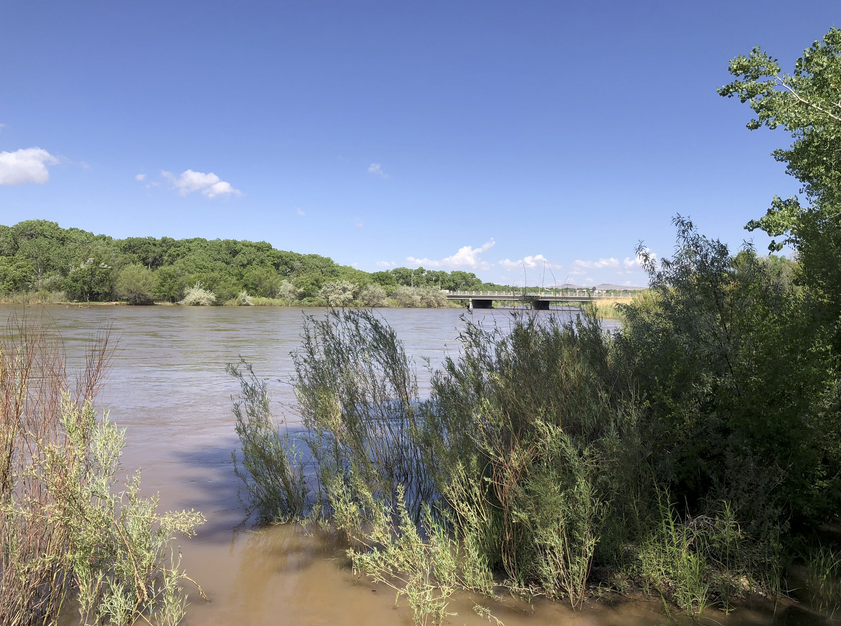
Out for an early walk this morning to the Rio Grande, we found a river settling nicely back into its main channel after a couple of months during which we allowed it to play a bit. Since April, the river’s been up and out of the 600-foot wide channel dug for it in the late 1950s, a gentle frolic through the woods – our “bosque” – that flank it through Albuquerque.

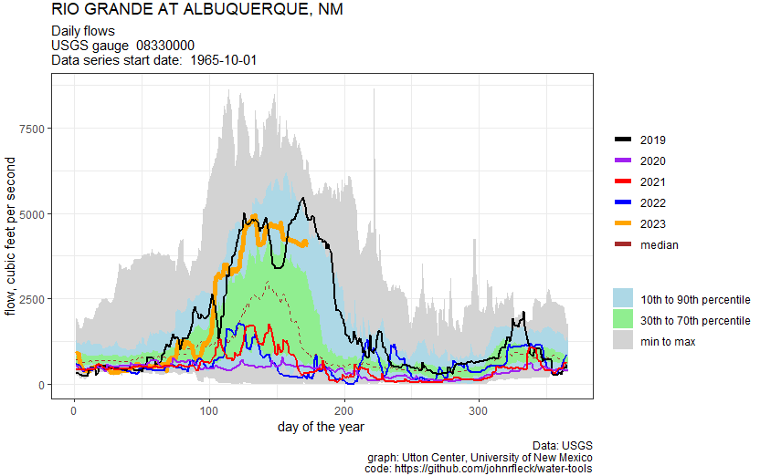
But it’s July 1, so play time’s over, as the river’s managers have throttled the river’s flow. In the last week, the river’s dropped from ~4,000 cubic feet per second at Albuquerque’s Route 66 bridge to 1,240 as I write this.

Rectifying a Flood Menace

Old newspaper headline and story: "Rio Grande Definite Flood Menace, Agree non-arguing KOB speakers'

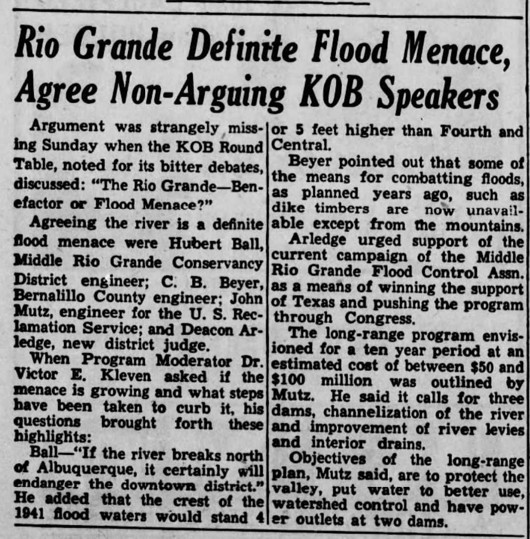
On this we can agree.. Albuquerque Journal, Sept. 1, 1947

I’m playing with language here. One of things I’m thinking hard about as I write the new book about Albuquerque’s relationship with the Rio Grande is the words we use to describe our river. For a good chunk of the time we’re looking at, from the late 1800s through the mid-1900s, “flood menace” was an incredibly common phrase.

“If the river breaks north of Albuquerque, it will certainly endanger the downtown district,” Middle Rio Grande Conservancy District chief engineer Hubert Ball explained in this 1947 newspaper account of a (radio? TV?) Sunday talk show.

For decades, the Rio Grande had been slowly “aggrading”, dropping sediment and raising its channel above the growing city on the valley floor. The flood of record in the modern era, in 1941, brought water in the Rio Grande’s main channel four or five feet higher than downtown Albuquerque. The levees that year barely held.

The Middle Rio Grande Conservancy District was formed in 1925 in large measure to create a framework for Albuquerque’s collective action to fight the flood menace. But it quickly became clear that the effort was a failure. The newly built levees were not enough, and the river’s bed kept rising. (As an aside, one of the chief reasons it was failing was financial – the District was perpetually broke. Subject for another blog post, and many chapters of the book.)

In 1947 (the year the KOB speakers agreed that the Rio Grande was a “flood menace”), the Bureau of Reclamation and Army Corps of Engineers, encouraged by local communities, offered up a plan. It basically amounted to a federal takeover of management of the river, with federal $$$$ to back it up.

The language they used to describe the project is super interesting. In addition to building a network for flood control dams on the major upstream tributaries of the Middle Rio Grande, the offered a plan for what they called “channel rectification”. To rectify, per OED, is “to restore to a normal or proper condition”. Much like the agency’s name itself – “Reclamation”, to “reclaim” – the language implies a vision of nature where human engineering prowess could correct the flaws of the natural world.

Training a River

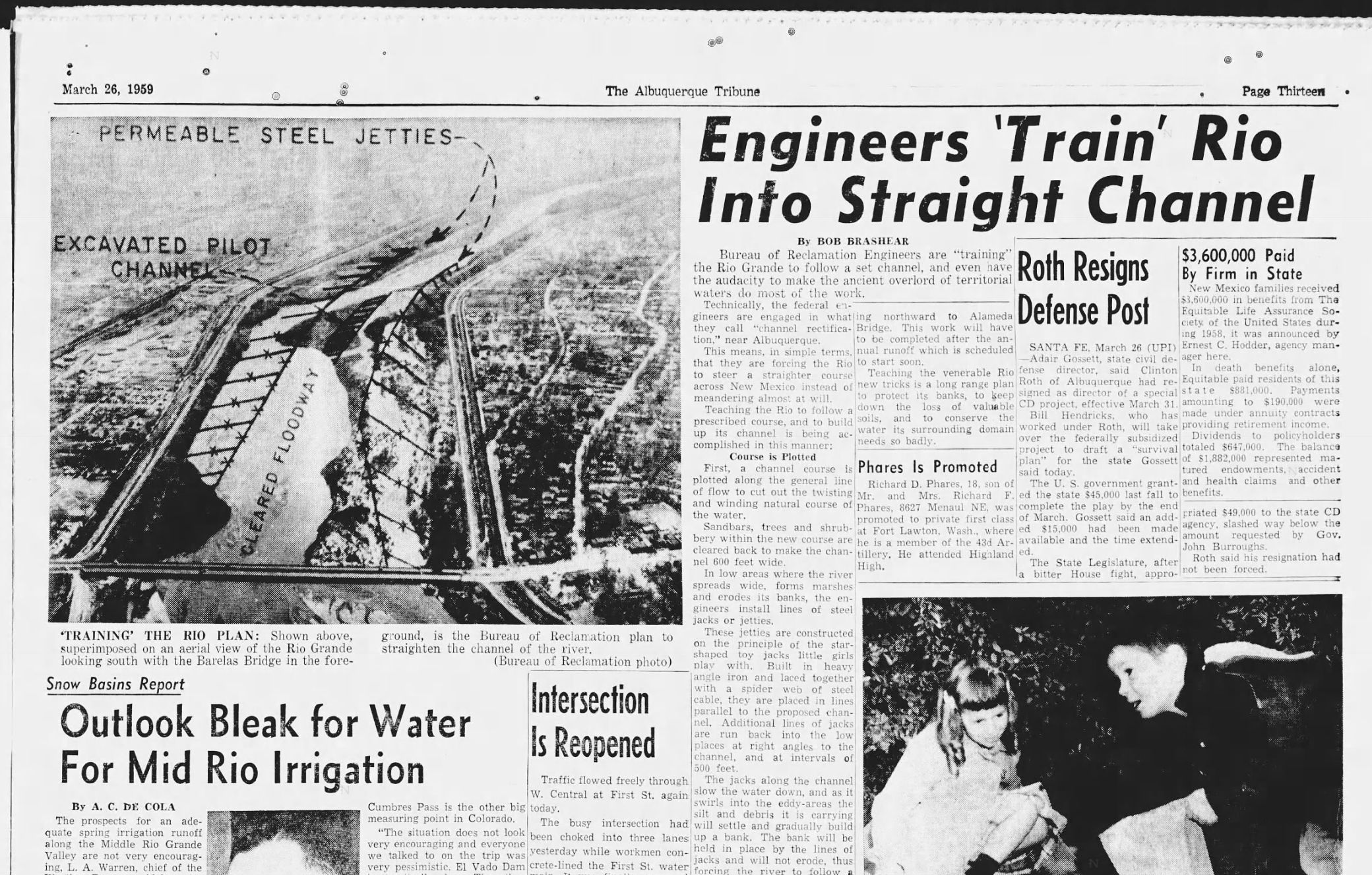
It took more than a decade of institutional wrangling for the channel rectification work to get underway (Again, subject for another blog post some time, or read our book as soon as we finish writing it! Spoiler alert: paying for it was again the key.). In trolling newspaper archives, I stumbled across this gem of an explanation, by Bob Breshear in the Albuquerque Tribune, March 26, 1959.

Engineers ‘Train’ Rio Into Straight Channel

Bureau of Reclamation Engineers are “training” the Rio Grande to follow a set channel, and even have the audacity to make the ancient overlord of territorial waters do most of the work.

The idea was to dig “pilot channels” at key locations, with “jetty jacks” along its bank lines – tangles of 16-foot steel beams so named because they look like childrens’ toy jacks – to capture sediment and anchor the river’s banks. “Sandbars, trees and shrubbery within the new course are cleared back to make the channel 600 feet wide,” Breashear explained to his Albuquerque Tribune readers.

In low areas where the river spreads wide, forms marshes and erodes its banks, the engineers install lines of steel jacks or jetties.

Can’t have that!

In the book writing, I’m wrestling with a challenge – the a desire to avoid cheap anthropomorphizing of the Rio Grande while at the same time recognizing that it’s a central character in the book. Brashear felt no such constraint. The engineers, he wrote, were “teaching the Rio”.

The Oxbow sandbars

There’s a stretch of river just downstream from where we were walking this morning, at the foot of bluffs on Albuquerque’s west side, where the Rio Grande is now doing the teaching.

It’s a spot where Reclamation dug an aggressive pilot channel in the summer of 1959, creating a new path for the river and stranding an old oxbow meander curling along the edge of the bluff, which remains as the best river-connected wetland for miles. (The story of the Oxbow gets a whole chapter in the new book.) In the low flows of 2020 vegetation, mostly willows, began growing on a sandbar adjacent to the Oxbow, pinching Reclamation’s 600 foot wide channel in half. With a couple of low flow years, the vegetation has become well established. With this year’s high flows, the water got up over the sandbar, but when we were out last Sunday, it looked like the willows we’re holding.

It’s a pattern we’ve been seeing for a while in the stretch of river south of Albuquerque, as sandbars grow and then become vegetated within Reclamation’s old 1950s-era 600 foot channel. The Rio Grande is, on a small scale, mimicking what it once did more broadly as it meandered down the valley. We’re increasingly seeing the same thing here in the Albuquerque reach. River’s gonna do river things.

I’ll head back out to the Oxbow next week now that the water’s down, and report back on the results.

The Book

The book is Ribbons of Green: The Rio Grande and the Making of a Modern American City, by John Fleck and Robert Berrens, to be published as part of UNM Press’s New Century Gardens series. As soon as we finish writing it.


After a high-flow spring, Albuquerque’s Rio Grande is about to drop in a hurry

River with bridge in background and water flowing through willows in foreground

Rio Grande overbanking at Albuquerque’s Central Avenue Bridge, June 2023

We’ve been having a great year on the Rio Grande through Albuquerque, with overbanking flows to delight the river nerds and mosquitos alike.

But this is about to change. Beginning next week (June 26, 2023), the Army Corps of Engineers will begin dropping flows out of Cochiti Reservoir, the main stem dam upstream of town.

The Institutional Hydrograph

“Hydrograph” is the water nerd term for a graph that shows the flow of a river, with time on the x axis and flow on the y axis.

A “natural hydrograph” on a river like the RIo Grand shows base flows in winter, a rising limb beginning in spring as the snow melts, dropping by usually around this time of year as the last of the snow comes off. Then we dwindle back toward base flows, plus whatever ups and downs we get from the summer rains.

graph showing colored lines for different flow years on the Rio Grande

A hydrograph of flows this year on the Rio Grande through Albuquerque.

The “institutional hydrograph” is a term we might have made up, or maybe borrowed from somewhere I don’t remember, that explains how water management rules reshape the curves.

The rules here are many, and they interact in complicated ways. If you look at my graph (click to embiggen it), for example, you see a weird bump in flows every winter. That’s water being moved downstream to meet the requirements of the Rio Grande Compact. That’s an institutional hydrograph – rules, not the natural system, defining the flow of the system.

Overbanking and rules

The Rio Grande Compact is one of the drivers behind the strange hydrologic pattern we see in the Middle Valley right now – a main channel full of water, which in many places rises high enough to get up out of that main channel and flow back into the woods.

The river’s current configuration – a 600 foot wide main channel, with long strips of cottonwood forest on either side – is the result of state and federal management decisions in the 1950s to narrow and straighten the river’s channel, to more efficiently move water downstream to meet our Rio Grande Compact obligation to the pecan and chile farmers in southern New Mexico and folks in Texas. (I’m in the midst of writing that chapter of our new book Ribbons of Green.)

In olden times, before we did all of this, what we now call “yay overbanking” was called “Menace! Flood! Our adobe houses are melting!”. But with the dams and levees in place, I can now enjoy with relatively minor inconvenience of my bike trails being underwater and swarms of mosquitos.

What comes next

Current releases are about 5,000 cubic feet per second, but on Monday the Corps plans to start dropping releases by 500 cfs per day until inflows equal outflows. There’s still about 30,000 acre feet of water sitting in Cochiti, water held back to manage the risk posed by high flows downstream. After July 1, that water will sit likely remain in Cochiti until next fall, after the irrigation season is over.

So beginning July 1, we’ll be operating the Middle RIo Grande as an inflow-outflow system. I will not try to explain the rules in detail that are in play here, because I’ve not done the due diligence to be sure I’ll get the explanation right. I’ll save that for later, for the book.

But know that if you are in Albuquerque and are enjoying the overbanking and high flows, get out to see it in the next week.


Schmidt et al: How we got here on the Colorado River Overview

Graph with horizontal bars showing declining Colorado River flow

A declining Colorado River. Via Schmidt, John C., Charles B. Yackulic, and Eric Kuhn. “The Colorado River water crisis: Its origin and the future.” Wiley Interdisciplinary Reviews: Water (2023): e1672.

Jack Schmidt, Charles Yackulic, and Eric Kuhn have published an invaluable new overview of how we got into this mess on the Colorado River, and some of the things we need to think about to get out of it.

Schmidt, John C., Charles B. Yackulic, and Eric Kuhn. “The Colorado River water crisis: Its origin and the future.” Wiley Interdisciplinary Reviews: Water (2023): e1672. (I think that’s an open link, if for some reason it doesn’t work – I’m sitting on a university campus right now, so my Internet may be tunneling past a paywall – drop a note in the comments and I’ll find a way to help y’all get to it.)

They’ve pulled together the best available data on supply and water use in the basin, and touch on the major issues that must be addressed going forward.

Some highlights:

21st century trends

The present water crisis has arisen, because average Basin-wide consumptive uses exceeded the natural supply throughout the 21st century. Between calendar year (CY) 2000 and CY2020 (the most recent available year of Upper Basin data), consumptive uses and losses were 15.1 million af/yr (18.6 billion m3), approximately 1.5 million af/yr (1.9 billion m3) more than the average supply for the same period…. The overuse of water was sustained for more than two decades by significantly draining of reservoir storage, especially from Lake Mead and Lake Powell where more than 80% of the total Basin-wide reservoir storage capacity exists. Between January 2000 and April 2023, the combined contents of Lake Mead and Lake Powell declined by 33.5 million af (41.3 billion m3) (Figure 4), and those two reservoirs are now 30% of capacity.


On the supply-use imbalance

Although it is easy to articulate the general principal that use must match supply, it is more difficult to precisely define the magnitude of the needed reduction….  Assuming persistence of conditions like those of the past 20 years, use would have to be reduced by 1.5 million af/yr (2 billion m 3 /yr) to match supply, but an additional 1 million af/yr (1 billion m 3/yr) of reduction would be needed to recover lost reservoir storage. Thus, to stabilize the reservoirs, Basin-wide use would have to be reduced to 12-13 million af/yr (15-16 billion m 3 /yr), 13-20% less than the average during the 21st century.

On the environmental challenges

The constraints on improving ecosystem conditions in the Colorado River delta are formidable, because most of the modern channel is dry. However, a binational collaboration of nongovernment organizations (NGOs), federal and state agencies, and universities have created patches of native vegetation that attract birds and other wildlife. Water is routed to these restoration sites using the existing network of Mexican irrigation canals…. Opportunities to recover additional areas of native riparian vegetation and to reestablish base flows depend on negotiations focused on revising reservoir operating and shortage agreements, including a new Minute of the binational water treaty, and the ability of the NGOs to raise funds to support their on-the-ground restoration work.

and

the future of the Grand Canyon ecosystem is tightly linked with decisions regarding reservoir operations and water use. In the context of the Law of the River, flow through Grand Canyon represents the delivery of water from the Upper Basin to the Lower Basin. In the context of environmental conditions in Grand Canyon, the magnitude of annual volumes as well as the amount of water stored in both reservoirs are significant drivers of ecosystem conditions.

If you are trying to understand the current situation on the Colorado River, there is no better place to start. It’s going into the fall syllabus for our UNM Water Resources course.

Deadpool Diaries: “Crisis on the Colorado River – From Short-Term Solutions to Long-Term Sustainability”?

Ringside seats to the decline of Lake Mead

Ringside seats to the decline of Lake Mead

I learned stuff at last week’s Getches-Wilkinson Center Colorado River conference at the University of Colorado Law School.

I learned:

  • The bodacious snowpack means the chance of Lake Mead dropping below elevation 1,000 is zero.
  • We still need to cut 1.5 million acre feet of Colorado River water use, at least. We still have no plan to do that.
  • We remain at risk of river flows past Lee’s Ferry dropping low enough by 2026 to trigger a legal argument about what the Upper Basin really owes the Lower Basin.
  • We have what was called a “historic accord” to reduce Lower Basin use in the short run, which muchly revolves around paying people to not use water.
  • The “historic accord” does not take any steps toward resolving longstanding tribal and environmental inequities.
  • The problem of what economist Gordon Tullock called “the transitional gains trap” is a very real obstacle to moving forward on the Colorado River.

Whatever, let’s just pay ’em: the “transitional gains trap”

In a seminal 1975 paper, economist Gordon Tullock nailed the problem at the heart of the current Colorado River policy dilemmas:

Many government programs which appear to be designed to help some particular industry or group do not seem to be succeeding. The explanation offered here is that the program, when inaugurated, generated transitional gains for the individuals or companies in the industry, but that these have been fully capitalized, with the result that the people in the industry now are doing no better than normal. On the other hand, the termination of the particular scheme would, in general, lead to large losses for the entrenched interests.

Thus farmers in places like Palo Verde, Yuma, and Imperial umpty generations ago benefited from the significant subsidies from the rest of us (federal taxpayers) that enabled Lower Colorado River agriculture to flourish. The benefit of that subsidy has now been fully capitalized in the land and the structures of the communities.

As Tullock’s work so clearly notes, termination of this “scheme” (I love his word) would “lead to large losses for the entrenched interests.”

While there’s a lot of “property rights” framing around our 21st century arguments about this, it’s important to remember that the perfection and continued use of those water rights was enabled by massive collective action on the part of others in establishing the needed institutions, and funding and building infrastructure.

But whatever, right? That’s where we are now, and a fatalistic attitude of “let’s just pay ’em” seems to have settled over basin problem solving, at least in the short term.

Is there a “transitional losses trap” too?

I’m definitely out over the tips of my conceptual skis here, but one of the things that was made clear at the Boulder meeting was something I’ll glibly dub “the transitional losses trap”: the same decisions over the last century that locked in “transitional gains” for Lower Basin farmers also locked in “transitional losses” for Native American communities dispossessed of their land and water.

In a powerful panel last Thursday afternoon, a stage full of tribal leaders one at a time talked about that dispossession. The sheer weight of their words, and the range of their concerns, was breathtaking.

Some progress has been made on this issue, especially in Arizona. But there is no escaping the reality that all that water providing “transitional gains” to Lower Basin farmers is, acre foot for acre foot, a “transitional loss” for Native American communities. And now we’re paying those Lower Basin farmers to not use this very same water.

I get that some of the money we’re paying to reduce water use will go to Arizona and California tribes with settled water rights. But there are many tribes without settled water rights, or with rights that are settled but not yet put to use. They’re getting nothing out of any deal to pay water rights holders not to use their water. We need to remember this fact every time we pay a non-Indian farmer not to farm.

“A historic accord”

California’s lead negotiator on the recently announced agreement for short term Lower Basin water use reductions, J.B. Hamby, called it a “historic accord”. I have to agree, though we’ll have to wait through the next many months before we have clarity on what sort of history has been made.

It’s a Lower Basin agreement, among Arizona, California, and Nevada. One of the things that was abundantly clear at the Boulder meeting was that Upper Basin states are withholding judgment until the details are fleshed out.

But it’s already clear that those who negotiated the deal want our money – federal tax dollars – to solve the transitional gains trap, but not to solve any of the other problems worth talking about:

  • the Colorado River Basin’s tattered environment
  • unresolved Native American water rights and other needs

As I’ve pointed out previously, with other people’s money should come other people’s values.

The Lee’s Ferry conundrum

My buddy/collaborator/coauthor/mentor Eric Kuhn threw up a scary slide during his talk:

10-year deliveries at Lee Ferry could drop below 82.5 maf in 2026 or 2027 – almost certainly by 2030 (remember the 5 straight 9.0 releases from 2015-2019).

The crucially nerdy backstory is in Article III(c) and (d) of the Colorado River Compact, which seem to say the Upper Basin is required to send 82.5 million acre feet every ten years. As Hamby noted, one of the premises of “we need to cut 1.5maf in the Lower Basin” is that the Upper Basin continues to hit that target. Lawyers will argue forever about Article III interpretation, but I’d prefer not to hand over our management of the Colorado River to a judge’s ruling on who’s right.

Arizona v. California

No arguments broke out over California’s insistence on enforcing its priority rights and pushing most of the climate change risk onto Arizona. Yay!

But the deep entanglement between this question and the transitional gains trap stuff I mentioned before isn’t going away. California farmers have benefited from a “property right” essentially created in 1968 through the use of power politics, but that property right, as Tullock would say, is now priced into the value of their assets. And we’ve now set a “whatever, let’s just pay ’em” precedent (at an unprecedented scale), which does seem historic, but maybe not in a good way.

Elevation 1,000

There were a number of mentions of the Reclamation modeling that puts the risk of Lake Mead dropping to elevation 1,000 at zero.

This is great news. It shows how the bodacious snowpack bailed us all out.

But we should remember that “keeping Lake Mead above elevation 1,000” is a very low bar.


Boulder and the roots of privilege

Black and white photo of a man on a balcony, painting

Robert Fleck at Bad Kissingen, Germany, June 1945

BOULDER – I spent a few nights last week in a $200-plus a night hotel in Boulder, Colorado, that someone else paid for. It was bigger than the first apartment Lissa and I lived together in. That’s privilege, I guess?

There was some Colorado River stuff going on in Boulder – huge thanks to the Getches Wilkinson Center for getting us all together, renting a hall, and footing the bill. Lots to talk about there at some point.

But I also had a chance to think about the GI bill and a young artist named Robert J. Fleck who spent a couple of years in Boulder after he got out of the army in 1946, making his peace with a war we infer he hated and making a new life as an artist.

Dad, GI bill money, and a life in art

I argue here that the Servicemen’s Readjustment Act – the GI bill – made me. A government policy made me.

Dad wanted to make art (the photo above is my favorite picture of him – dragging his paints across Europe – London, D-Day+N, VE Day). Absent the GI bill, dad would likely have returned to a Pennsylvania steel mill. As early as 1942, less than a year after Pearl Harbor, the National Resources Planning Board began talking about how to deal with the economic complexity of soldiers returning from war, flooding the workplace at the same time wartime production was winding down. My dad at that point was a young draftee with artistic inclinations being trained in photography (In Hollywood! The Army sent my dad to Hollywood to learn photography!)

The result of these things was twofold. First, at a micro level, my dad began a life carrying cameras along with his paints. Second, at a macro level, the government created a massive post-war education program that sent guys like my dad to art school – and a bunch of other schools:

Approximately eight million veterans received educational benefits. Under the act, approximately 2,300,000 attended colleges and universities, 3,500,000 received school training, and 3,400,000 received on-the-job training. The number of degrees awarded by U.S. colleges and universities more than doubled between 1940 and 1950, and the percentage of Americans with bachelor degrees, or advanced degrees, rose from 4.6 percent in 1945 to 25 percent a half-century later.

The result was a chance for a guy like my dad to live a life of art, doing for the rest of his life the same thing he did all across Europe in that dreary, awful trek across Europe – dragging along his sketchbook and cameras and paints and seeing and recording and reacting to his world. The years in Boulder to get a GI bill-funded “Master of Fine Arts” was a ticket to a stable career teaching art at a junior college in California, a ticket of entry to a world that would have been closed off a generation before.

The way he modeled that life is the great gift he gave me. For me it was notebooks and pens, but the schtick is the same – seeing and recording and reacting to the world. It’s the gift he gave to me, the life he handed me, and it has been a delight.

But I am mindful of the privilege. The phrase “a guy like my dad” above was carefully chosen.

While there is some debate among historians, (see here for a discussion of disparities among African Americans, and here for a discussion of the challenges faced by women artists), it seems likely my dad’s white guy privilege played a role.

The lists of artists who the GI bill launched, who remade post-war American art, is wonderful. It is the art I was surrounded with growing up, the art – beyond my dad’s work – that helped make me. I love this art.

It’s also almost all white guys.

It’s that privilege, along the with the world view, that was handed on to me when a completely unqualified John Fleck began doing radio news and writing words for newspapers thirty years later. I didn’t know shit and people kept giving me jobs! I’ve done OK in the years that followed, but I know I entered that world with a golden ticket already in hand.


Deadpool Diaries: Paying to fallow may not save as much water as we think

Given that we’re about to spend a billion dollars to fallow land to reduce water use in the Colorado River Basin, it’s reasonable to ask how we can be sure we know how much water is actually being saved.

The answer, according to new work by Katharine Wright and colleagues at Arizona State University, may be “not as much as we think.”

Wright and her colleagues looked at the oldest and most well-understood rotational fallowing program in the west – the Metropolitan Water District-Palo Verde Irrigation District deal set up two decades ago to fallow land in PVID and use the water to shore up Met’s Colorado River Aqueduct supplies.

Their key finding: over the time period studied, actual savings were far smaller than MWD’s estimates.

The key difference in their work, as compared to the techniques used to derive official estimates, is an effort to analyze farmer behavior – the choices of which fields to enroll in the fallowing program and farmers’ cropping and irrigation practices on non-fallowed fields. If farmers fallow fields that would have used less water anyway, or use more water on the non-fallowed fields, it could sway the estimates.

In other words, water saved by fallowing is not simply a physical science question. It is a behavioral science question as well.

To be clear, I’m not saying Wright and her colleagues are correct here. The technical details are complicated, and I’m not qualified to judge. I’m saying that this is a serious and importantly, independent effort to estimate how much water is really being saved.

As we prepare to spend a billion dollars to fallow a bunch of land to conserve a bunch of water, we should be attentive to the incentives. Who has an incentive to make the savings we’re getting for our billion dollars look big? Who has an incentive to maximize the amount of water we get in the reservoirs for our billion dollars?

A huge thanks to my colleagues at the University of New Mexico Water Resources Program, who have been looking at rotational fallowing here in New Mexico (we’re all wrestling with these questions) and brought Wright’s work to my attention.

And as always, a big thanks to Inkstain supporters, who make this possible.

Deadpool Diaries: The Law of Shipwrecks

abandoned boat at Lake Mead

“That boat is totally fixable.” – Greg

That boat is totally fixable.

– Inkstain reader Greg

This raises a fascinating legal question: whose boat is it?

43 U.S. Code § 2101

The Congress finds that—
(a) States have the responsibility for management of a broad range of living and nonliving resources in State waters and submerged lands; and
(b) included in the range of resources are certain abandoned shipwrecks, which have been deserted and to which the owner has relinquished ownership rights with no retention.

I am not a lawyer, but as I read the statute, the state of Nevada pretty clearly has a responsibility here to protect the shipwrecks of Lake Mead for the enjoyment of all.

Historical Perspective on the Accounting for Evaporation and System Losses in the Lower Colorado River Basin

Over the past year, the question of how to account for evaporation and system losses in the Lower Colorado River Basin has become a hot political and policy topic. With the recent Lower Basin water use reduction scheme, we seem to have set the question aside for now. But it’s not going away.

My Science Be Dammed co-author Eric Kuhn and I have just published a dive into the issues:

Water management of the Lower Colorado River has long sidestepped the questions of how to account for and assess the impact of reservoir evaporation and system losses. To date, the preferred strategy has been to ignore those losses. The hydrologic gap left by this approach, which leaves an imbalance between the water flowing into Lake Mead and the amount released for downstream users, has been covered by simply releasing water stored in Lake Mead from the wet decade of the 1990s ensuring that no user bears the brunt of a legal interpretation that might reduce their supply. This disconnect between the river’s allocation framework and hydrologic reality is the result of longstanding governance failures by the U.S. and the Lower Basin states – Arizona, California, and Nevada – including failure of the U.S. to factor in reservoir and system losses in the 1944 Treaty with Mexico and failure of the states to negotiate a Lower Basin compact to apportion their share of the river.


Deadpool Diaries: June 1 Colorado River system status report

abandoned boat at Lake Mead

I hope someone’s keeping track of the re-submergence of the Lake Mead shipwrecks.

Lake Mead ended May 2023 at elevation 1,054.28 feet above sea level. That’s up five feet in a month, at a time of year when the reservoir is usually dropping, so I guess yay? It’s also up 6 1/2 feet from last year, so I guess yay?

But also worth noting: Mead is down 32 feet from May of 2019, the year the oddly-named “Drought Contingency Plan” was signed. I say “oddly named” because the clear outcome here suggests that our plan for the contingency of drought must have been to drain Lake Mead.

2023 water use forecast

We’re far enough into the year that we can get a pretty good feel for how deeply Lower Basin water users are cutting in response to the current crisis.

Total cuts from the states’ base allocations are 1.079 million acre feet, which is less than the 1.2 million acre feet in Reclamation’s classic “Structural Deficit” calculation, and well below the 1.5 million or more – a 20 percent reduction – that’s been widely discussed as the need in a climate-change altered Colorado River Basin.

Here’s how the cuts are being made in 2023:

  • California: 4.178 million acre feet, a 5 percent reduction from California’s base allocation
  • Arizona: 2.031 million acre feet, a 27 percent reduction from Arizona’s base allocation
  • Nevada: 212,000 acre feet, a 29 percent reduction from Nevada’s base allocation

Those numbers are forecasts for calendar year 2023, based on Reclamation’s June 2 analysis.

We can argue over whether this is “fair” – I’ve made my case here – but the reality is that Arizona and Nevada right now are contributing disproportionately to the cuts needed to save Lake Mead.

A big part of the reductions for 2023 are based on the requirements of the 2007 Interim Guidelines and the Drought Contingency Plan. (Puzzled over why Arizona and Nevada have to make cuts under the ’07/DCP and California doesn’t? California’s power politics in the 1960s gave it higher priority rights.)

In response to the near term crisis on the river, California is taking an additional 5 percent in cuts this year beyond the ’07/DCP requirements, Arizona is taking 6 percent, and Nevada is taking 24 percent.

state base allocation 2023 2023 reduction percent cut from base 07/DCP Cut beyond ’07/DCP
California 4,400,000 4,178,000 222,000 5% 0 5%
Arizona 2,800,000 2,031,000 769,000 27% 592,000 6%
Nevada 300,000 212,000 88,000 29% 17,000 24%


End of year forecast

The latest Reclamation 24-month study has Mead ending calendar 2023 at elevation 1,062.32.

Despite this year’s monster snowpack and the gazillions of federal dollars currently chasing water use reductions, that’s still down 28 feet since the end of 2019, the year the DCP was signed.

Thanks

A big thanks to my supporters – Inkstain will always be free, your help makes it possible.

Deadpool Diaries: The Case for a Shitty Deal

Wrecked speedboat next to reservoir.

Maybe if Lake Mead rises enough this year the boats will be back underwater and we can stop worrying about deadpool.

I’ve had long conversations this week with smart friends grudgingly supporting of the Lower Basin deal to reduce Colorado River water use over the next few years. Their case for it is simple. Yes, it’s an awful deal in so many ways, but it does have the potential to generate some short term water use reductions and cut the red wire on the ticking time bomb.

SNWA’s John Entsminger made the case this way in an interview Monday with Colton Lochhead at the Las Vegas Review Journal:

“I do think this proposal gives us what we need over the next three years, which is critical,” John Entsminger, general manager of the Southern Nevada Water Authority, said in an interview Monday. “We have serious work to do in terms of longer-term, more durable solutions to be implemented post-2026. It’s an important deal reached by the states today because it gives us the room to work on those longer-term problems.”

My friends making this argument have a crucial credential that I don’t have in making their “sure whatever, it’s terrible but let’s just smile politely and get on with things” argument: they have been or are in the room for negotiations like this. I’m just heckling from the cheap seats.

Yay savings!

The best thing about the deal is an apparent commitment (see below for my reasons for italicizing) to deeper reductions in Lower Basin water use than folks down at that end of the system have been willing to agree to in the past. Three million new acre feet of savings above and beyond what has already been agreed to falls well short of the two to four million acre feet Reclamation Commissioner Camille Touton told us last year would be needed, but with a big snowpack the numbers have changed.

But the savings fall short of what we know is needed

It’s been clear for as long as I’ve been writing seriously about the Colorado River that, if the Upper Basin meets its (contested) Lee Ferry delivery obligation, the Lower Basin needs to cut 1.2 million to 1.5 million acre feet per year. Permanently. Three million acre feet from 2023-26 falls well short of that.

For more than two decades, the Lower Basin has been dithering over how to make the cuts and in the meantime draining the reservoir, essentially building the time bomb that we’re now trying to defuse.

To be clear, enormous progress has been made in the last two decades to build the necessary institutional widgets to bring the system into balance.I wrote a whole book about it! My purpose in writing the book was to build a case for three things:

  • that fears communities often have about the impact of water reductions are misplaced – that we can all get by with less water
  • that successful institutional widgets had been built based on collaboration and sharing that could allow us to adapt
  • that a lot more work was needed to cut far more deeply than we had by the time I handed in the book’s manuscript in December 2015

But in the midst of crisis, and with a ticking bomb, we still haven’t been able to come up with even the bare minimum that we’ve all known for decades that we need in Lower Basin cuts.

We don’t actually know what the deal is

What we’ve got at this point documenting the deal is a “term sheet” and a round of celebratory press releases. We have no official breakdown of the makeup of the 3 million acre feet – what’s California’s share, Nevada’s, Arizona’s – how much is Imperial and Metropolitan and Palo Verde, how much is CAP and Yuma. We’ve got individual state reps telling reporters (shout out to my friends in the fourth estate for trying to push down the path of actually breaking down the numbers). But that’s not the same thing as all of us being able to look at it in writing rather than passing around news site links, to be interpreted like fragments of a Dead Sea scroll.

The deal at this point is a pile of stuff shrouded in a tarp that we’re not allowed to peak under. We’ve just gotta trust the Lower Basin folks that they’ll actually come up with the water.

The reason, as one of my smart “been-in-the-room-where-it-happens” friends pointed out, is that the actual detailed reductions will need to go before the boards of a bunch of water agencies. Which hasn’t happened yet. Which means there are umpty reasons for this to spin out of control.

It crucially depends on federal money flowing to water users to compensate them for water they don’t use, but as Janet Wilson pointed out this week in the Desert Sun, we’ve already missed the chance to save some of that water this year because of bureaucratic stuff. That process is not going well.

We all remember the ducking and diving around the celebrated “500 Plus Plan”. Know, those of you who know what’s under the tarp, why those of us who don’t are legitimately nervous about your approach to cutting the red wire.

So spare me the celebratory press releases and puff pieces about politicians breaking roadblocks.

Yo, Upper Basin here, remember us?

The “seven state letter” is comical, but also revealing.

Nothing in this letter should be construed as an Upper Basin endorsement of the Lower Basin Plan. However, building on the historical success of the Seven States working together to solve the challenges confronting the Colorado River, the Seven States support the submission by the Lower Division States of the Lower Basin Plan to Reclamation concurrent with the submission of this correspondence.

One imagines federal officials desperate to somehow fly a seven-state flag over the deal, and the last-minute phone calls and emails over the weekend aimed at drafting a letter that says something.

At this point, Upper Basin communities (That’s me! Hi!) are just hostages in the next room, unable to help defuse the bomb and hoping y’all down there can figure out how to cut the right wire.

It’s even worse that y’all in the Lower Basin are demanding that the federal taxpayers kick in a billion dollars or you won’t cut any wire at all.

Wait. Which wire was it we were supposed to cut?

Oh shit. Was it the red wire we were supposed to cut? The blue one?