Co-Equal Goals

Jerry Brown

Jerry Brown

Mark Reisner, in Cadillac Desert, describes Jerry Brown’s struggle back in the late 1970s and early ’80s to sort out the conflicting interests surrounding the Bay-Delta System as plans were developed for what was then known as the Peripheral Canal:

Jerry Brown’s dilemma – which was insoluble, but which he thought he could solve anyway – was trying to please the water lobby and his large environmental constituency at the same time. He wanted a project, but he wanted it to be “environmentally sound”.

Fast forward to the 2008 Delta Vision Report, which provides the the underpinnings for the latest attempt to solve the delta problem:

The Delta ecosystem and a reliable water supply for California are the primary, co- equal goals for sustainable management of the Delta.

And the guy who inherited the struggle to carry it out is California Gov. Jerry Brown.

update: To be clear – I’m not arguing here that the historical lesson to draw between the parallels is the insolubility, to borrow Reisner’s wonderful word. Rather, it is the parallel structure in the way the problem was defined then and now – co-equal goals today and pleasing the water lobby and the environmental constituency. I’m very interested in the search for the solution space today, and not at all convinced that it is insoluble.

Our water, our values

Here’s one of those societal water value questions that doesn’t get a lot of attention. How cool are massive waterfalls?

“Breathtaking, that’s what it is,” said Lynne Bousie of Scotland, who stopped to pose for a photograph at the spot where the paved trail to Yosemite Falls makes a turn and the first full view of its entire 2,425-foot drop comes into view.


River Beat: Drop 2 From Space

Drop 2 From Space

Drop 2 From Space

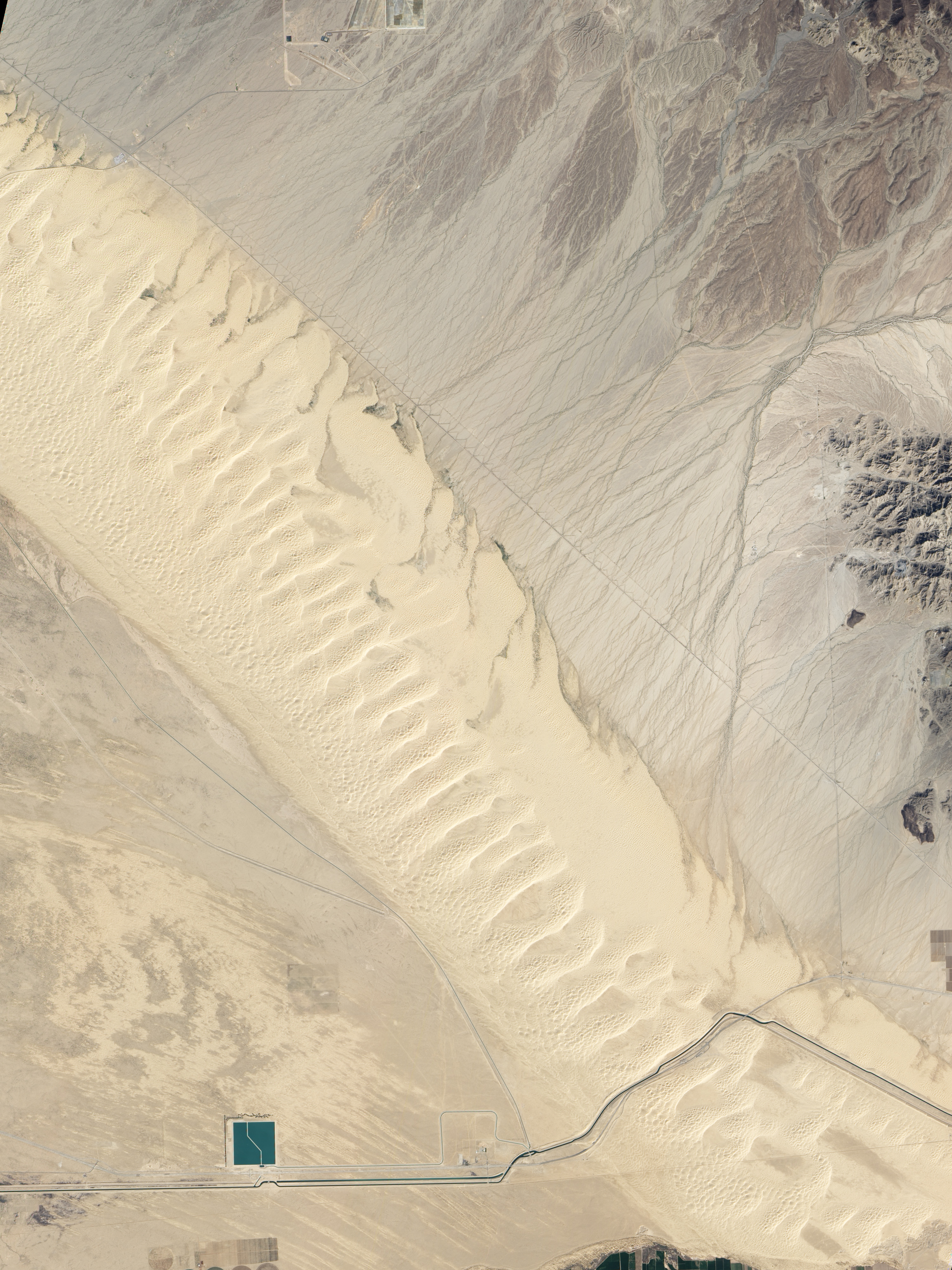
One of the strangest western water projects of recent years is the Drop 2 Reservoir on the All-American Canal.

Here’s the problem. Irrigators in southeastern California, mostly in the Imperial Valley, get their water from the Colorado River. It sits in storage behind Lake Mead, and when they need it, they put in a request for a release from the Bureau of Reclamation, which releases it on schedule a couple of days ahead of when it’s needed. If it rains between the time it’s released and the time they’re scheduled to use it, they won’t need it. In the olden days, it would flow on down for use in Mexico or on out to the delta – wasted, in the view of the water managers.

Drop 2 allows the water to be captured and stored for later use. So it won’t be “wasted.” The Lower Basin states shared the cost in return for shares of the water saved.

Which is a long way of introducing this very cool NASA satellite photo of the Algodones Dunes, the major landscape feature that defines the southern edge of the Salton Sink and is a far prettier part of the NASA satellite picture you see (click through for bigness). Unless you’re a water nerd, in which case Drop 2 is the star. It’s the little bluish square on the bottom left.

Its new name is the Warren H. Brock Reservoir, after an Imperial Valley luminary. But I will forever want to call it “Drop 2.”

Background on Drop 2 from Shaun McKinnon, the Arizona Republic’s excellent water guy.

Three Gorges: Spanning the Environmental Kuznets Curve

Environmental economists talk about the relationship between affluence and environmental values – the idea that a society’s desire for things like clean air and water are low when folks are poor, but as basic needs for food and shelter are satisfied, environmental desires rise. It’s captured notionally in the “Environmental Kuznets Curve”. It’s not a perfect tool (lots of argument over the cases in which it doesn’t seem to have much explanatory power – see the Wiki page for a good discussion), but I think it’s a useful tool.

Which is a circular way of approaching the current discussion in China over Three Gorges Dam. Elizabeth Economy at CFR explains the Chinese government’s willingness to acknowledge the dam’s enormous problems:

It has only taken ninety years, but China’s leaders have finally admitted that the Three Gorges Dam is a disaster. With Wen Jiabao at the helm, the State Council noted last week that there were “urgent problems” concerning the relocation effort, the environment and disaster prevention that would now require an infusion of US$23 billion on top of the $45 billion spent already.

This strikes me as a project that was planned and begun when China was well down on the EKC, when of course it made sense to build a big giant dam regardless of those pesky environmental (and other) consequences because it would help make them less poor. As China’s affluence drags it up the curve, remorse is setting in.


River Beat: On the lack of a plan

Rob Davis at Voice of San Diego has an excellent explainer this week on his community’s dependence on Colorado River water, and the central problem of what happens if Lake Mead gets really low:

If the Colorado consistently comes up short, no one knows who will cut consumption to keep Lake Mead from running dry. A short-term plan is in place from the time the reservoir hits 1,075 feet above sea level until 1,025 feet. Arizona and Las Vegas take that hit. (At 895 feet, the reservoir wouldn’t be able to distribute water and the Hoover Dam wouldn’t produce power. The lake is currently at 1,096 and climbing.)

Hitting those triggers would be monumental. At 1,025 feet, the reservoir would be a 25-foot drop away from cutting off Las Vegas. Someone would have to take less water to stop the decline. But there is no plan on how to ensure water gets to the big city in the middle of the desert — only an agreement that states will meet to negotiate. And with the vicious politics that can thrive around water, that meeting won’t be easy. It would require Mexico, California, Arizona or Nevada to give up some of their water.

I think Rob nails the central dilemma here – the question of now how will we use less water (taking ag land out of production, urban conservation, slow/no growth, etc.) but how the various parties on the river will allocate the shortages. That’s the horse – the shortage allocation process. The cart pulled behind, then, will determine how the individual water-using entities will conserve to make up their share of shortages.

The Water Pricing Dilemma

Janet Zimmerman in the Riverside (Calif.) Press Enterprise on what happens to water agencies when their customers use less:

Water use has dropped by double digits across Southern California as residents heeded the call to conserve.

As a result, water district revenues fell drastically. Metropolitan Water District of Southern California, the wholesaler that supplies most local agencies, saw water sales decline by $16 million between March 31 of last year and this year.

The agency raised rates to compensate for that and other shortfalls from investments, and the cost ultimately was passed on to consumers. This year alone, Metropolitan’s prices rose 7.5 percent in January and will jump another 7.5 percent in the coming months; they follow two increases of 14.3 percent and 19.7 percent in 2009.

“In a year when they’re not selling as much water, they have to pass on those fixed costs. If they’re selling less, there’s less acre-feet to divide it over and they have to pass it on,” said John Rossi, Western’s general manager.

Leaving Water in the River

When Lissa and I were up in Santa Fe a few months back, I took along the binoculars and took a walk along the Santa Fe River as it passes the old city’s downtown, hunting birds. I found few. Because it’s not much of a river, really.

As David Groenfeldt notes, there’s an effort underway to change that, but it’s an odd one:

Two weeks ago here in Santa Fe, our City Council voted to keep the Santa Fe River flowing a little bit through this very dry Spring and Summer. This is path-breaking for a river designated in 2007 as the Most Endangered River in America. The City has other sources of water (including a new $250m pipeline from the nearby Rio Grande) so it is not losing anything by being generous, but in the words of Councilwoman Patti Bushee, it is an important symbolic effort: “When do we recognize that some of the water belongs to the river?”

This is a great example of the way we sort out competing values surrounding water here in the arid West. The dominant value has long been consumptive – using water for farms and cities. Rivers themselves, and the ecosystems that surround them, have been left behind. I’m not arguing this is good or bad. It’s simply reflective of the values of the people making the decisions.

Water for rivers themselves is a different set of values, and increasingly we’re seeing efforts to accommodate those values as well. In Santa Fe, they’ve done this in part by developing, as Groenfeldt notes, “new sources of water”, which means a $250 million pipeline and treatment system to pump water uphill from the Rio Grande to meet the city’s water supply needs. That water, in turn is being imported via the San Juan-Chama Project from the headwaters of the San Juan, in the Colorado River Basin. So less water for the Colorado River Basin, in part, allows water to be left in the Santa Fe River.

Stuff I Wrote Elsewhere: A Feud Over Lower Rio Grande Water Distribution

From the morning paper, a look at the way this year’s drought has laid bare a Byzantine argument over how to properly divide up the waters of the Lower Rio Grande between Texas and New Mexico farmers (sub/ad req.):

Water flows down the Rio Grande in southern New Mexico today, past parched farmers who cannot touch it, to irrigate land in Texas.

New Mexico state water officials are not happy. They have signaled an interest in taking their concerns to court.

But the Elephant Butte Irrigation District, the agency that represents the interests of the New Mexico farmers currently going dry, doesn’t want the help.

The district’s representatives say they are just fine with the current situation. In fact, they were the ones who negotiated and signed off on the deal that is allowing the water to flow past their own farmers and on to Texas.


Why Some NM Schlub Cares About the Sacramento Delta

I’ve triggered some puzzlement among California water folks as I call around trying to understand the Sacramento-San Joaquin Delta in preparation for my trip out there next month. Why does a New Mexican care? Other than the fact that it’s fascinating, of course. I mean what water wonk wouldn’t be fascinated by California’s water problems. But beyond entertainment value,  but what’s the connection?

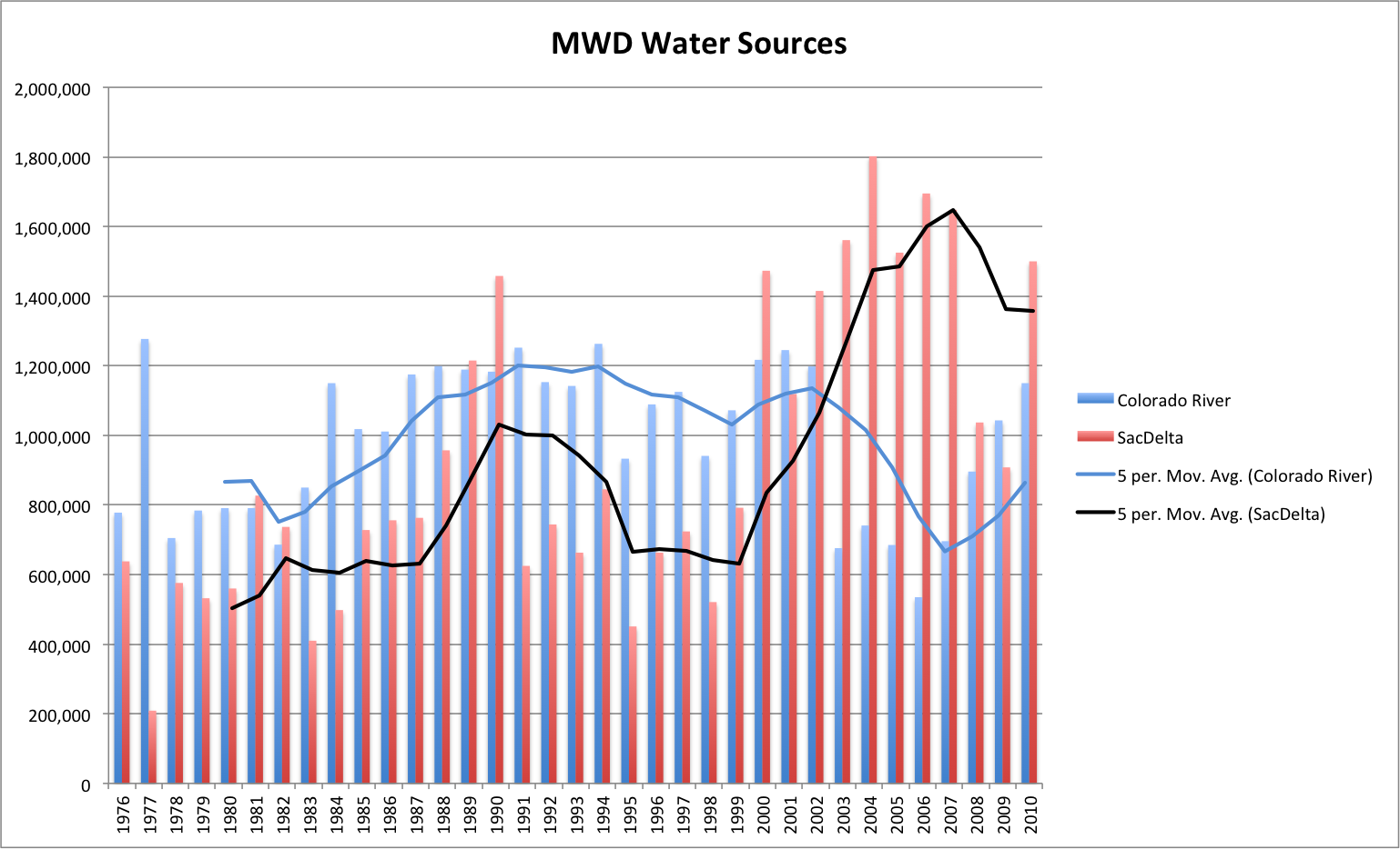
This graph (click to embiggen it) should help answer the question. It’s the Metropolitan Water District of Southern California’s water imports from the Colorado River and from the State Water Project’s Sacramento-San Joaquin Delta pumps. It shows a significant shift in southern California’s water sources beginning in 2000.


MWD Water Imports

MWD Water Imports

Why?

The answer lies in what folks in Colorado River management call “the 4.4 plan”. Under the Colorado River Compact and related laws and court decisions, California is legally entitled to 4.4 million acre feet of Colorado River water per year.

But for years, there was enough extra sloshing around the system that California was able (legally) to take more. Here’s Bennett Raley, Assistant Secretary of the Interior, explaining the situation during a 2002 congressional hearing:

The State of California has for decades received water in excess of the baseline quantity of 4.4 million acre-feet available to it in a normal, non-surplus year. The 4.4 million acre-feet of water available to California in a normal year is sufficient to meet the needs of agricultural interests such as the Palo Verde Irrigation District (PVID), the Yuma Project, the Imperial Irrigation District (IID) and the Coachella Valley Water District (CVWD) each year, and still fill a good portion of the Colorado River Aqueduct which helps to fuel the economy of coastal California.

The remainder of the Colorado River Aqueduct has been filled in past years with additional water not used by the States of Nevada and Arizona or water made available in years of surplus. Neither the historical fact of the repeated, and lawful, release to California of water not taken by Nevada or Arizona, nor the present reality of the dependency of California on this additional water, can alter the terms of the Decree. California has no legal right to the continued use of water in excess of 4.4 million acre-feet in a normal year. Nor does California=s use of additional water during times of surplus alter the immutable laws of nature. The Colorado River will have periods of surplus, periods of normal flow and periods of drought.

As the Central Arizona Project fully came on line, California had to bring its usage down to reflect that reality. One thing that happened is that the Metropolitan Water District’s use of Colorado River water went down, and its use of State Water Project water, pumped from the delta, went up, as the graph above shows.

And as Mike Taugher reminded us last week:

An increase in Delta pumping during the 2000s coincided with the collapse of several fish species….

Albuquerque began drinking Colorado River water two years ago. Santa Fe began drinking Colorado River water this year. We’ve joined hands with y’all out in California. And the cascading effects from our big river basin to yours shown in that graph are reminder of how our water infrastructure (both physical and institutional) is increasingly interconnected across much of the West. As are our problems.

As Pat Mulroy likes to say, we’ve created “the largest artificial watershed in the world.”


Flood Plains in the Desert

The drama on the Mississippi has spawned a lot of good writing on the disconnect between how nature thinks about flood plains versus how we think about them. As Anne Jefferson wrote, the bits next to our rivers tend to be the most desirable places to live:

People are drawn to settle on floodplains – because rivers provide transportation corridors, but mostly because floodplains are the most fertile soils on Earth. Those fertile soils are there because flooding creates floodplains, bringing in the sediment and nutrients that make rich, agriculturally-productive soils.

Rio Grande Flood, Belen NM, 1941

Rio Grande Flood, Belen NM, 1941, USFS

But precisely the same reasons that make them so attractive also make them the vulnerable:

The river gave their land value (whether they realized the soil connection or not), but it also gave them misery. They wanted the benefits of the river, but not its floods.

Robert Simmons at NASA’s Earth Observatory blog had an interesting followup comment in part to Anne’s piece and in part to other discussions on the EO blog:

In response to Map of the Ancient Mississippi a few of you left comments to the effect of “no one should live in floodplains.” It’s an appealing notion, but I think it’s unrealistic.

Simmons’ accompanying map shows why it is unrealistic – much of the development of the midwest is “in floodplains”.

It’s a notion that applies here in central New Mexico, where much of the core of Albuquerque has been built in the natural Rio Grande flood plain. In an arid climate the flood story is different in fundamental ways from wet climate rivers. Far more of our water management infrastructure is built around the “not enough” part of the water problem, rather than the “too much” side of the natural range of variability.

But we flood too, and building in the flood plain extracts a very similar price. Much of the history of early 20th century water development in the middle Rio Grande Valley is a history of managing the wet side of the natural range of variability – figuring out how to farm in the flood plain while managing the inevitable flood problem. The picture above is from the great flood of 1941. Peak flows through Albuquerque of 25,000 cubic feet per second* are tiny compared to what we’re seeing on the Mississippi, but it’s all relative. That was more water than the system at the time could handle, and led to the flooding you see in the picture and, eventually, construction of Cochiti Dam upstream from Albuquerque.

Before Cochiti was built, according to an analysis done for the US Army Corps of Engineers by Mussetter Engineering (pdf), flow here regularly topped 10,000 cfs, but hasn’t since.

Today, the Army Corps water management guidelines put the maximum permitted flows at just 7,000 cfs through Albuquerque, though they try to keep it below 5,000 cfs because of aging spoil bank levees and irrigation structures along this stretch of the river that have difficulties with water that gets any higher.

Our river is pinned between levees through town, and most folks here, to the extent they think about this at all, think the river is “over there” and don’t realize they’re living in a natural flood plain.