Leaving Water in the River

When Lissa and I were up in Santa Fe a few months back, I took along the binoculars and took a walk along the Santa Fe River as it passes the old city’s downtown, hunting birds. I found few. Because it’s not much of a river, really.

As David Groenfeldt notes, there’s an effort underway to change that, but it’s an odd one:

Two weeks ago here in Santa Fe, our City Council voted to keep the Santa Fe River flowing a little bit through this very dry Spring and Summer. This is path-breaking for a river designated in 2007 as the Most Endangered River in America. The City has other sources of water (including a new $250m pipeline from the nearby Rio Grande) so it is not losing anything by being generous, but in the words of Councilwoman Patti Bushee, it is an important symbolic effort: “When do we recognize that some of the water belongs to the river?”

This is a great example of the way we sort out competing values surrounding water here in the arid West. The dominant value has long been consumptive – using water for farms and cities. Rivers themselves, and the ecosystems that surround them, have been left behind. I’m not arguing this is good or bad. It’s simply reflective of the values of the people making the decisions.

Water for rivers themselves is a different set of values, and increasingly we’re seeing efforts to accommodate those values as well. In Santa Fe, they’ve done this in part by developing, as Groenfeldt notes, “new sources of water”, which means a $250 million pipeline and treatment system to pump water uphill from the Rio Grande to meet the city’s water supply needs. That water, in turn is being imported via the San Juan-Chama Project from the headwaters of the San Juan, in the Colorado River Basin. So less water for the Colorado River Basin, in part, allows water to be left in the Santa Fe River.
Stuff I Wrote Elsewhere: A Feud Over Lower Rio Grande Water Distribution

From the morning paper, a look at the way this year’s drought has laid bare a Byzantine argument over how to properly divide up the waters of the Lower Rio Grande between Texas and New Mexico farmers (sub/ad req.):

Water flows down the Rio Grande in southern New Mexico today, past parched farmers who cannot touch it, to irrigate land in Texas.

New Mexico state water officials are not happy. They have signaled an interest in taking their concerns to court.

But the Elephant Butte Irrigation District, the agency that represents the interests of the New Mexico farmers currently going dry, doesn’t want the help.

The district’s representatives say they are just fine with the current situation. In fact, they were the ones who negotiated and signed off on the deal that is allowing the water to flow past their own farmers and on to Texas.


Why Some NM Schlub Cares About the Sacramento Delta

I’ve triggered some puzzlement among California water folks as I call around trying to understand the Sacramento-San Joaquin Delta in preparation for my trip out there next month. Why does a New Mexican care? Other than the fact that it’s fascinating, of course. I mean what water wonk wouldn’t be fascinated by California’s water problems. But beyond entertainment value,  but what’s the connection?

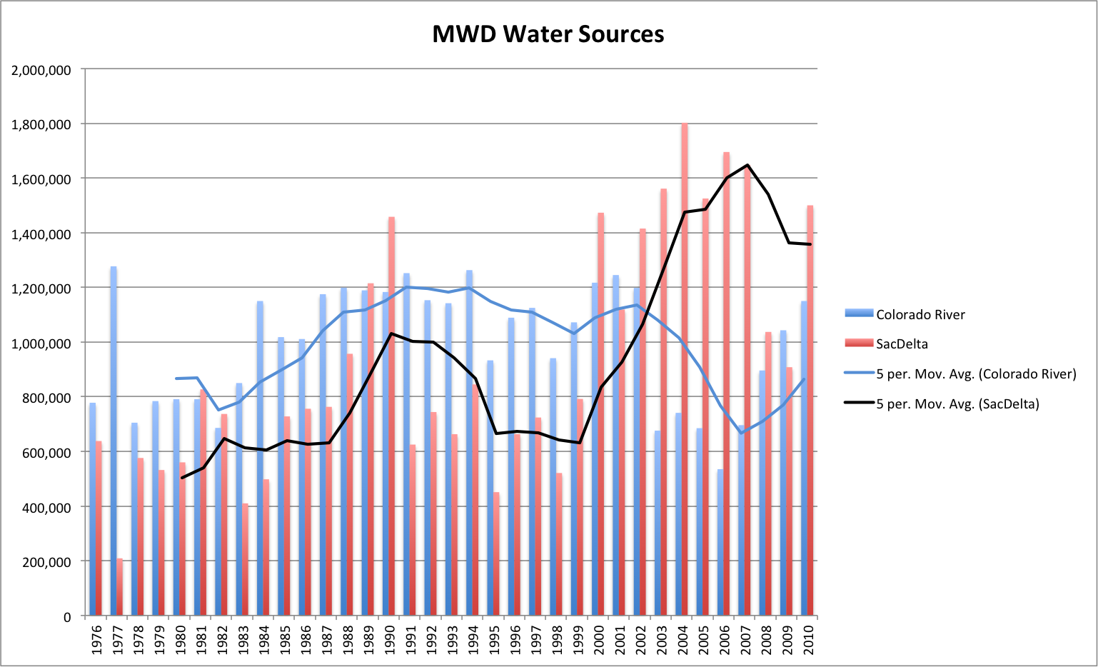
This graph (click to embiggen it) should help answer the question. It’s the Metropolitan Water District of Southern California’s water imports from the Colorado River and from the State Water Project’s Sacramento-San Joaquin Delta pumps. It shows a significant shift in southern California’s water sources beginning in 2000.


MWD Water Imports

MWD Water Imports

Why?

The answer lies in what folks in Colorado River management call “the 4.4 plan”. Under the Colorado River Compact and related laws and court decisions, California is legally entitled to 4.4 million acre feet of Colorado River water per year.

But for years, there was enough extra sloshing around the system that California was able (legally) to take more. Here’s Bennett Raley, Assistant Secretary of the Interior, explaining the situation during a 2002 congressional hearing:

The State of California has for decades received water in excess of the baseline quantity of 4.4 million acre-feet available to it in a normal, non-surplus year. The 4.4 million acre-feet of water available to California in a normal year is sufficient to meet the needs of agricultural interests such as the Palo Verde Irrigation District (PVID), the Yuma Project, the Imperial Irrigation District (IID) and the Coachella Valley Water District (CVWD) each year, and still fill a good portion of the Colorado River Aqueduct which helps to fuel the economy of coastal California.

The remainder of the Colorado River Aqueduct has been filled in past years with additional water not used by the States of Nevada and Arizona or water made available in years of surplus. Neither the historical fact of the repeated, and lawful, release to California of water not taken by Nevada or Arizona, nor the present reality of the dependency of California on this additional water, can alter the terms of the Decree. California has no legal right to the continued use of water in excess of 4.4 million acre-feet in a normal year. Nor does California=s use of additional water during times of surplus alter the immutable laws of nature. The Colorado River will have periods of surplus, periods of normal flow and periods of drought.

As the Central Arizona Project fully came on line, California had to bring its usage down to reflect that reality. One thing that happened is that the Metropolitan Water District’s use of Colorado River water went down, and its use of State Water Project water, pumped from the delta, went up, as the graph above shows.

And as Mike Taugher reminded us last week:

An increase in Delta pumping during the 2000s coincided with the collapse of several fish species….

Albuquerque began drinking Colorado River water two years ago. Santa Fe began drinking Colorado River water this year. We’ve joined hands with y’all out in California. And the cascading effects from our big river basin to yours shown in that graph are reminder of how our water infrastructure (both physical and institutional) is increasingly interconnected across much of the West. As are our problems.

As Pat Mulroy likes to say, we’ve created “the largest artificial watershed in the world.”


Flood Plains in the Desert

The drama on the Mississippi has spawned a lot of good writing on the disconnect between how nature thinks about flood plains versus how we think about them. As Anne Jefferson wrote, the bits next to our rivers tend to be the most desirable places to live:

People are drawn to settle on floodplains – because rivers provide transportation corridors, but mostly because floodplains are the most fertile soils on Earth. Those fertile soils are there because flooding creates floodplains, bringing in the sediment and nutrients that make rich, agriculturally-productive soils.

Rio Grande Flood, Belen NM, 1941

Rio Grande Flood, Belen NM, 1941, USFS

But precisely the same reasons that make them so attractive also make them the vulnerable:

The river gave their land value (whether they realized the soil connection or not), but it also gave them misery. They wanted the benefits of the river, but not its floods.

Robert Simmons at NASA’s Earth Observatory blog had an interesting followup comment in part to Anne’s piece and in part to other discussions on the EO blog:

In response to Map of the Ancient Mississippi a few of you left comments to the effect of “no one should live in floodplains.” It’s an appealing notion, but I think it’s unrealistic.

Simmons’ accompanying map shows why it is unrealistic – much of the development of the midwest is “in floodplains”.

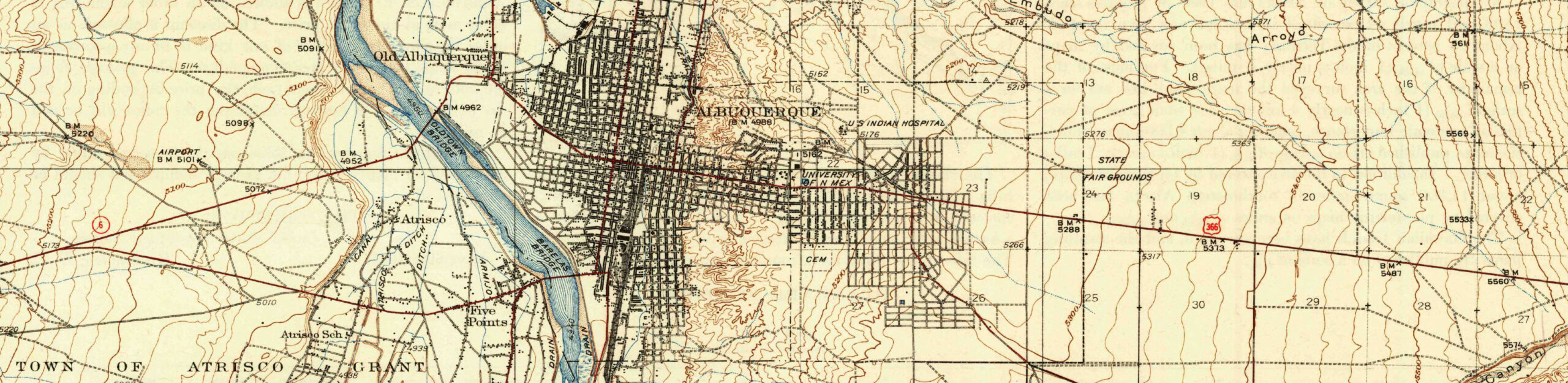
It’s a notion that applies here in central New Mexico, where much of the core of Albuquerque has been built in the natural Rio Grande flood plain. In an arid climate the flood story is different in fundamental ways from wet climate rivers. Far more of our water management infrastructure is built around the “not enough” part of the water problem, rather than the “too much” side of the natural range of variability.

But we flood too, and building in the flood plain extracts a very similar price. Much of the history of early 20th century water development in the middle Rio Grande Valley is a history of managing the wet side of the natural range of variability – figuring out how to farm in the flood plain while managing the inevitable flood problem. The picture above is from the great flood of 1941. Peak flows through Albuquerque of 25,000 cubic feet per second* are tiny compared to what we’re seeing on the Mississippi, but it’s all relative. That was more water than the system at the time could handle, and led to the flooding you see in the picture and, eventually, construction of Cochiti Dam upstream from Albuquerque.

Before Cochiti was built, according to an analysis done for the US Army Corps of Engineers by Mussetter Engineering (pdf), flow here regularly topped 10,000 cfs, but hasn’t since.

Today, the Army Corps water management guidelines put the maximum permitted flows at just 7,000 cfs through Albuquerque, though they try to keep it below 5,000 cfs because of aging spoil bank levees and irrigation structures along this stretch of the river that have difficulties with water that gets any higher.

Our river is pinned between levees through town, and most folks here, to the extent they think about this at all, think the river is “over there” and don’t realize they’re living in a natural flood plain.

Stuff I Wrote Elsewhere: Lessons from a Drought

From the morning paper, a wander in the bosque to look for signs of drought (sub/ad req.):

There is a resilience, it turns out, to these desert ecosystems. They’re used to this happening every so often, and they know what to do in response. Some leaf out less, or leaf out later. Some depend on deep roots that reach down to groundwater. Some shut down water to parts of the body, sacrificing branches to save their core.


Levee Lessons

Jeffrey Mount and Jay Lund (UC Davis water guys) draw lessons for California from Morganza and the lower Mississippi:

In the Central Valley, those in the floodplain operate under an old adage: You hope that the other guy’s levee fails first. For political, economic and legal reasons, our institutions have been unable to move beyond this ad hoc system toward a new paradigm – designating areas suitable for emergency floodwater storage and bypass, and providing adequate compensation as an incentive.


Stuff I Wrote Elsewhere: Rafting on Drinking Water

May 10, 2011 NM Drought Monitor

May 10, 2011 NM Drought Monitor

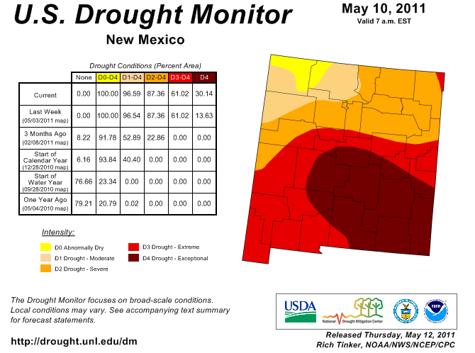
How dry is it this year in New Mexico? So dry that rafters on the Rio Chama will have to use spare drinking water, pumped through the system weekends this spring and summer, for their fun. From Friday’s ABQJournal (sub/ad req, I think):

Albuquerque has to move its water supplies down the Rio Chama sometime, so why not do it on the weekends, when it can help river runners?

That is the gist of an agreement announced Thursday between the Albuquerque Bernalillo County Water Utility Authority and federal agencies that manage the river.

The water, imported to the Rio Grande Basin from the headwaters of the San Juan-Chama Project, currently sits in storage in high mountain reservoirs. Eventually, the water utility would release it for use in the city’s new drinking water system.

The new operations plan merely calls for its release sooner, allowing it to flow down a stretch of the Chama that has been designated a “Wild and Scenic River” and is popular with recreational boaters.

Karl Moffatt offered up a more detailed look at the river recreation picture in Friday’s New Mexican:

White-water thrill seekers will be lucky to see a high-water rafting season this year because of below-average snowpack and a lack of real runoff.

Complicating matters are the ongoing drought, low soil moisture conditions, warm, windy weather and a storm-stingy La Niña pattern.

“It looks like it’ll be poor runoff season for rafting,” says Wayne Sleep of the USDA’s Natural Resources Conservation Service in Albuquerque, which monitors snowpack and other water conditions. “The snowpack is melting, but it’s just not making it to the streams.”

River Beat: The Myth of a Busted La Niña Forecast

There’s a myth that has firmly taken hold of a busted La Niña forecast on the Colorado River this year. It shows up this morning in a Las Vegas Review-Journal editorial.

No.

This issue came up last September, as we were heading into the La Niña season. It was a common misapprehension back then, and it seems to have stuck. Here’s the reality, as I wrote back then, based on conversations with the folks at the Colorado Basin River Forecast Center – the ones who actually do the forecasting:

La Niña’s strongest effect is found in the southern part of the basin, while most of the Colorado River’s water comes from the northern part of the basin.

There’s almost zero correlation between La Niña/El Niño and Colorado River runoff. There may have been people saying they expected a dry year on the river, but it wasn’t the actual forecasters.

updated with an, umm, minor edit

More Tunnel Talk

I’m a big fan of beat reporting – steady, day-in, day-out attention to a topic. I love to do it, and when I’m trying to learn a new topic, the first place I turn is to the beat reporters who cover it.

Today’s example is the Stockton Record’s Alex Breitler, who cut through the noise a couple of days ago to explain what state water official Jerry Meral had and had not said about the state’s views toward building a giant tunnel to divert water around the Sacramento Delta to points south:

People are tweeting today that the Brown administration will “seek” a smaller conveyance in the Delta, and that “big tunnels appear out.”

Easy, there.

What was said in yesterday’s Assembly committee hearing — and reported by the Bee’s Matt Weiser– is that a wide range of alternatives will be considered, including a 3,000 cfs pipe (five times smaller than the 15,000 cfs system described in last year’s Bay Delta Conservation Plan working draft).

A big tunnel isn’t “out.” It’s just that officials are no longer touting it as the leading solution.