Stuff I Wrote Elsewhere: the bridge at San Marcial

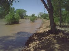
From this morning’s newspaper, a visit with John Horning to the railroad bridge at San Marcial (sub/ad req.), one of the choke points that prevents high flows on the Middle Rio Grande through central New Mexico:

The railroad bridge, and similar spots where too much water could damage property, prevent the high spring flows that used to spread out into riverside woods and regenerate the ecosystem.

Seven years ago, Horning points out, as part of an ecosystem restoration plan, federal officials committed to realigning the bridge to allow higher flows. The project is years behind schedule and looks like it may never be done.

To Horning, executive director of the Santa Fe-based WildEarth Guardians, the choke point at San Marcial is a big deal.

Others argue this is the new reality on the Rio Grande….

Valencia County farmer Janet Jarratt argued in an interview that what farmers do in diverting water from the river each spring, spreading it out and greening up the valley floor, is the closest thing we have anymore to the natural Rio Grande flows of the past.

At a talk last year Jarratt, the current chair of the board of directors of the Middle Rio Grande Conservancy District, interspersed slides of wonkish water policy bullet points with pictures of cranes in her fields as a reminder of what she was talking about.

“We have to think about what ‘the ecosystem’ means,” Jarratt said.

The tension between those two viewpoints is a familiar one in the West precisely because they are so hard to reconcile. Neither is “right” in any absolute sense.

Different people value water and the natural world in different ways. We use our political system to sort out the resulting disagreements. This is how we ended up with the Rio Grande we have — heavily engineered, designed first and foremost to move water for human use and prevent flooding. That is largely what the people who live here, acting through their political institutions, seem to have wanted.

River Beat: Mead – Could Be Worse?

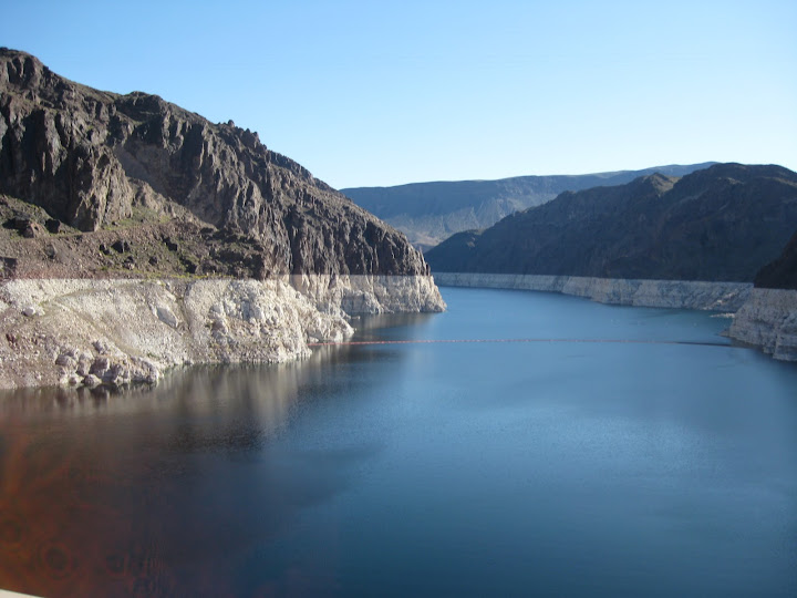
Lake Mead, April 2010, by John Fleck

Lake Mead, April 2010, by John Fleck

The surface of Lake Mead is at 1094.30 feet above sea level, the lowest June 1 reading since 1937, when it was first being filled. All I can say is it could be worse. That’s six inches higher than the forecast in the most recent 24-Month Study, the planning document used by the U.S. Bureau of Reclamation to offer its best estimate of lake levels over the next two years.

The even better news, if you could call it that, is that the current 24-Month Study calls for the reservoir to bottom out at 1084.21 feet in fall 2010, which means it will not drop below the level of 1083.57, the previous post-fill low, a mark set during the drought of the 1950s.

Links:

River Beat: “This makes ‘Chinatown’ look like high school.”

Kudos to the University of San Diego’s Watchdog Institute for producing, and to the Imperial Valley Press for running, an excellent look at what’s at stake in the upcoming Imperial Irrigation District election. IID, the irrigation agency formed in 1911 to take over the interests of commercial water developers on the California side of the Lower Colorado, controls more water than any other single entity on the Colorado River. So board elections there have far reaching implications.

Chinatown

Chinatown

This election is extra-important because of the entanglements associated with the Quantification Settlement Agreement, an attempt to reduce California’s water usage to within its legal share of the Colorado. To say that key pieces, involving fallowing Imperial Valley farm land, have been controversial is to make an understatement. From Denise Zapata’s story:

The candidates say the district faces a number of important issues, ranging from improving energy and water efficiency to tightening control of the agency’s finances. But nearly all — Ouzan wouldn’t comment for this story — say one of the top priorities is resolving the legal disputes over the Quantification Settlement Agreement, a document that spells out Colorado River water transfers from the Imperial Irrigation District to the San Diego County Water Authority, the Metropolitan Water District and the Coachella Valley Water Authority.

I commend the whole thing to your attention if Colorado River water management is important to you. Also, if you’re interested in the future of journalism, the model by which this was produced and distributed is worthy of note.

River Beat: When Saving Water is Not What It Seems

The JAWRA blog had a post Friday on something that I’ve found maddeningly difficult to explain to newspaper readers: the cases where water conservation efforts don’t really save the water one intuitively thinks they do:

Lining a canal, for example, may seem like “saving” water, but not if the leakage is replenishing a stressed aquifer.

For example, low-flow toilets in a place like Albuquerque, where return flows from the sewage treatment plant re-enter New Mexico’s water inventory via the Rio Grande, don’t generate the savings one might assume. To be clear, they’re probably a good idea for a variety of reasons, but a gallon saved at the toilet tank does not translate to a full gallon saved for the overall New Mexico water system.

At a water conference I attended several years ago, water historian, lawyer and judge Gregory Hobbs of Colorado explained how difficult a point this has been to get across in his state. Irrigators want to line canals to “save” water, but Colorado’s water law recognizes that the seepage replenishing groundwater is really water benefiting other water system users.

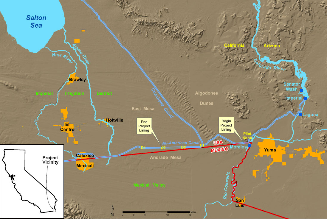
All-American Canal lining project, map courtesy USBR

All-American Canal lining project, map courtesy USBR

The most intriguing example of this right now here in the western United States is the lining of the All-American Canal, which diverts Colorado River water at Imperial Dam to provide irrigation and municipal water for the Imperial Valley. California water managers, desperate to squeeze every last drop from their Colorado River allotment, have turned to a concrete lining on 23 miles of the historic canal, which was built as a simple dirt channel. (OK, not so “simple”, it’s huge, one of the largest structures for moving water ever built, but you get the idea.)

The move will save an estimated 67,700 acre feet (84.5 million cubic meters) of water each year. But “save” here is a relative term. That water is soaking into the ground, where it replenishes an aquifer used by residents of the Mexicali Valley, across the U.S.-Mexico border. The attitude of U.S. officials toward the Mexicans’ loss is that it is not the United States water users’ problem. From a 2005 letter from U.S. Interior Secretary Gale A. Norton to Secretary Jose Luis Luege Tamargo, Secretary of Environment and Natural Resources of Mexico:

Secretary Gale A. Norton to Secretary Jose Luis
Luege Tamargo, Secretary of Environment and Natural Resources of Mexic …

This important project was authorized by Congress in order to conserve Colorado River water reserved to the United States under the 1944 Treaty between our nations regarding, among other provisions, the allotment of the waters of the Colorado River for any and all sources. . . . As these ongoing discussions between our nations are coordinated through the State Department and [the International Boundary and Water Commission], our efforts will continue to reflect our view that the United States does not have an obligation to mitigate for any potential effects in Mexico of lining the All American Canal and that each nation must continue to explore and develop mechanisms to improve the efficient use of the limited water supplies of the Colorado River.

The U.S. government also concluded that our nation’s environmental laws, including the Endangered Species Act, do not apply to effects caused by the project in Mexico.

More reading:

Stuff I Wrote Elsewhere: the Remarkable Botanical Collection of Brother Gerfroy Arsène Brouard

From this weekend’s newspaper (sub/ad req), a piece about UNM’s Museum of Southwestern Biology taking responsibility for the remarkable early twentieth century plant collection of Brother Gerfroy Arsène Brouard:

A Smithsonian scientist eight decades ago joked that the mosses and lichens of northern New Mexico were sure to suffer before the determined onslaught of Brother Gerfroy Arsène Brouard.

A botanical collector of prodigious energy and meticulous habits, “Brother Arsène” was in fact more of a benefit to the science of botany in New Mexico than he was a threat to the region’s plants. But he did collect an awful lot of them.

Now, thanks to a series of accidents, some happy and some sad, a scientifically rich collection of nearly 2,000 plants gathered and catalogued by Arsène from 1916 to 1938 has found a home at the University of New Mexico.

Tim Lowrey and his colleagues at the University of New Mexico’s Museum of Southwestern Biology took possession of the Arsène specimens earlier this month from the College of Santa Fe, rescuing the “orphan collection” from the financial collapse of that northern New Mexico institution.

It’s not just the dry places that are going dry

We arid climate types like to think we own water problems, but a new EU report serves as a reminder that they’re universal. People build their infrastructure and societal systems around the water they’ve got and then bump up against limits. From EurActive:

The report shows that some member states have begun to suffer “permanent scarcity across the whole country”. While the pressure point is currently in the south, with Cyprus experiencing the severest water shortages, the Commission expects water stress to spread to South-East and Central Europe….

According to the progress paper, the problem is not limited to Mediterranean countries. The Czech Republic has reported areas with frequent water scarcity, and France and Belgium have reported over-exploited aquifers, it notes.

River Beat: The View From the Head of the Stream

When the Colorado River Compact was negotiated in 1922 to divide the river’s flow among the seven western U.S. states that span its basin, the representatives of the upper basin states were driven by the realization that they weren’t using much water at the time, but some day they would want to.

Flaming Gorge Reservoir, Green River, courtesy USBR

Flaming Gorge Reservoir, Green River, courtesy USBR

Under western U.S. water law’s doctrine of prior appropriation, people who show up late to the party get less, but the compact’s negotiators locked in a share for the upper basin states for future use. That underlying principal is now on display in Wyoming, where worries are growing that a share of the water still unused might be lost. The AP’s Ben Neary had an excellent piece earlier this month exploring the dilemma:

Wyoming has an unusual problem among the states in the Colorado River system: lots of water and, other than supporting some fine trout fishing, no way to put a significant amount of it to use.

Yet increasing demand for water in the upper Colorado River basin, combined with new government predictions that climate change could reduce future water supplies, are ratcheting up concerns in Wyoming about how to preserve the state’s share for the day when it’s needed.

The fear in Wyoming involves its neighbors to the south, in Colorado, who are talking about major water project development that would move water from the Colorado Basin across the Continental Divide to the east slope, where Colorado’s biggest cities are located.

Wyoming’s surplus water situation has worried state lawmakers for years.

“At some point are they simply going to say, ‘You didn’t use it, and when you didn’t use it, you lost it,'” said Republican Rep. Kermit Brown of Laramie.

This may explain the rush to squeeze the last bits of water out of the unused Upper Basin share of the Colorado, a point that Jennifer Pitt of the Environmental Defense Fund made in Congressional testimony last month:

[T]here appears to be a race among the states to develop the next big use of water, because for water users who don’t get their straw into the system first, their risk of curtailment increases. This ‘race to develop’ increases risk for many water users in the basin. It would be better to slow down on new developments and first work out interstate agreements on what happens in the event of a call on the Compact.

Stuff I Wrote Elsewhere: More Water in the Desert than Usual

From the morning newspaper (sub/ad req), a look at water flowing through the woods:

Michael Porter made an auspicious discovery one morning this week in the waterlogged Rio Grande woods — silvery minnows.

For a week, high flows have brought water into newly created habitat on the river’s west side, south of Central, and the endangered Rio Grande silvery minnows have apparently wasted no time taking advantage of their new digs.

“They’re already moving in,” said Porter, a fish biologist with the U.S. Army Corps of Engineers. Porter’s discovery came the same day a host of dignitaries from local, state and federal agencies gathered to formally cut the ribbon on the Bosque Revitalization at Route 66, 121 acres of ecosystem restoration stretching along the west side of the Rio Grande through Albuquerque.

Water in the Desert: High Flows on the Rio Grande

If you’re in Albuquerque, it’s  a great weekend to go out and see your river.

The Rio Grande is flowing at nearly 6,000 cubic feet per second through the city right now (Saturday evening, 5/22), courtesy of a spike flow to help Rio Grande silvery minnow spawning. The high flows allow water to get out of the main channel and into constructed low areas along the Albuquerque reach of the river, as well as some minor overbanking into the bosque (0ur riverside woods) itself. As near as I can tell, it’s the highest flow we’ve had since 2005.

For those not familiar with the 21st century Rio Grande, our river once spread over a vast and shallow flood plain, miles wide. Today, it’s confined to a narrow central channel, and the ecosystem that used to thrive as high spring flows spread out across the valley floor has been choked off. What’s happening is a very modest simulation, at a small scale, of what used to be an annual affair.

I’ve been out of town all week and was afraid I would miss the peak flows, but when I got back from our trip at midday today, I checked the USGS web site

high flows on the Rio Grande

high flows on the Rio Grande

and saw it was peaking, so Nora and I went down this afternoon for a look. The picture was taken in one of the new constructed side channels, on the east side of the river just south of the Central Avenue (old Route 66) bridge. The channels are built to take water only when the river’s high, creating a shallow, slow water area for the fish to spawn.

There are some interesting issues with the engineering approach to ecosystem restoration, which I hope to find some time to explore next week for the newspaper. There are constraints on how much water you can allow down the river – primarily the railroad bridge at San Acacia, but also some levee issues and development in the flood plain. Some folks argue that fixing those problems would allow even higher flows, which would allow a more natural overbanking and reconnection between the ecosystem and the river.

(Sorry for the picture quality, taken with my cell phone camera.)

Not Everyone Thought Irrigating the Salton Sink was a good idea

Reading the late 19th and early 20th century literature of the Colorado Desert, one could be forgiven for thinking there was a certain inevitability of the massive irrigation works that so changed the Salton Sink (renamed with characteristic enthusiasm as “Imperial Valley”.)

It still seems inevitable. It was the time of manifest destiny, of “reclamation”. But I was pleased last night to stumble across a contrarian voice. It’s John C. Van Dyke, an eccentric art historian who chucked it all in 1898 and went for a horseback ride around the deserts of the southwest. For three years.

Van Dyke’s The Desert is a lyrical bit of nature writing to warm every desert rat’s heart. It’s also the only thing I’ve found written at the time (please, let me know of other examples) that questioned the wisdom of turning water into the Salton Sink:

It might be thought that this forsaken pot-hole in the ground would never come under the dominion of man, that its very worthlessness would be its safeguard against civilization, that none would want it, and that everyone from necessity would let it alone. But not even the spot deserted by reptiles shall escape the industry or avarice (as you please) of man.

Van Dyke’s epic wander and subsequent writing came as Charles Rockwood and the California Development Company were engaged in their first attempts to divert water northward from the Colorado River into the desert. Van Dyke makes an odd argument against it – that the great desert’s true valley came through its role “in the matter of producing dry air”:

To turn this desert into an agricultural tract would be to increase humidity, and that would be practically to nullify the finest air on the continent….

The deserts should never be reclaimed. They are the breathing-spaces of the west and should be preserved forever.