Mulroy Calls For Vegas Water Vote

It’s hard to resist the gunslinger metaphor when reading Henry Brean’s story about Pat Mulroy’s Las Vegas water pipe ultimatum:

To shore up support for a controversial project, Southern Nevada Water Authority chief Pat Mulroy will ask her board for an “up-or-down vote” on plans to pipe groundwater to Las Vegas from across rural eastern Nevada.

In a surprise announcement Thursday, Mulroy said she wants the vote held later this month “in order to show that the political will is still there to move forward with the project.”

The move comes in response to a recent surge in opposition to the multibillion-dollar pipeline, she said.

Mulroy is the larger-than-life manager of Las Vegas, Nevada’s water supply, and as Emily Green notes, “the project that has been the focal point of her career.” The argument is that there is a risk of Lake Mead dropping so low that Las Vegas’s water system goes dry, and that the pipeline, to bring in groundwater from hundreds of miles away a la Owens Valley, is critical to her city’s future. Critics disagree. The call for a vote is an attempt to get Las Vegas’s political leadership to put up or shut up.

This is high stakes western water politics, no doubt.

Riding the Ecotone

I rode up South 14 in the Manzano Mountains this morning with a couple of friends. It’s been hot in town, and the ride seemed like it would offer some mountain cool.

Albuquerque spreads across an alluvial plain at the base of the Sandia and Manzano Mountains, and once you get out of town and into Tijeras Canyon, the road takes you through a succession of neat ecosystems. This is on my mind because the Ecological Society of America is in town, and I hope to spend the better part of the next couple of days soaking in science. In other words, I had ecosystems a bit on the brain, and the South 14 ride is a great one for ecosystems.

Up Tijeras Canyon, old Route 66 follows an arid landscape riparian stream, but the real fun is on the hill slopes on either side of the canyon – some great piñon-juniper woodland. The hillsides are still dotted with dead trees – little bits of gray – from the dieoff during the drought of 2002-2003. The road turns south, and climbs up until, at about 7,000 feet elevation (2,100 meters) the road makes a big turn to the east and you see your first hillside of ponderosa.

That boundary – the line between the PJ and the ponderosa – is what ecologists call an “ecotone”. Back in 1998, I had my first serious exposure to the idea when Craig Allen and Dave Bresears took me hiking at Bandelier National Monument to show me the area where the PJ-ponderosa boundary had measurably shifted during the drought of the 1950s. The lowest elevation ponderosa had died back, and the PJ crept up slope.
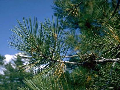
ponderosa needles

ponderosa needles

Conceptually it’s interesting, because it suggests something important about ecosystem response to climate variability, which was more on my mind at the time than was climate change. It’s a great paper (Drought-induced shift of a forest–woodland ecotone: Rapid landscape response to climate variation, Craig Allen and David Breshears, PNAS December 8, 1998 vol. 95 no. 25 14839-14842), but what really affected my thinking was walking in the woods with Dave and Craig and seeing the ecotone for myself.

Up South 14, the road follows the ecotone for a while before heading up into the Ponderosa. By the time we got to the top, about 7,500 feet (2,300 meters), the wind through the pines brought that vanilla smell you get in a ponderosa forest. On the ride down, you could feel directly the reason one kind of ecosystem thrives low, and the other thrives high. It’s a pretty fast descent, and we literally felt the air getting warmer as we went down.

This evening, going through the program for the ESA meeting, I noticed Craig’s giving a talk. I think I’ll drop by.

(picture of ponderosa needles courtesy National Park Service, because I forgot I could take a picture with my cell phone)

Arizona Groundwater

Shaun McKinnon, the Arizona Republic’s water guy, has a must-read piece in the paper’s Sunday edition about his state’s groundwater situation:

Thirty years after Arizona tried to stop cities and towns from using up their groundwater, the state still can’t shake its thirst for one of its most finite resources.

The steady drain on underground reserves grows out of two realities: Canals and pipelines don’t reach far enough to deliver surface water to everyone, and laws don’t reach far enough to stop people from drilling.

If the groundwater addiction continues unabated and under-regulated, the effects will be broad and potentially disastrous: Scarcer supplies could push rates higher and create uncertainty about water availability, discouraging new business and slowing economic growth. If wells start to run dry and aquifers collapse, the landscape could be dotted with fissures and sinkholes.

The piece shows how well-intentioned attempts at regulation, combined with abject failures, has combined to build what looks like an intractable problem as users turn to groundwater on times scales that create the appearance of supply on relatively short time scales, allowing societal infrastructure to expand apace, while ignoring the sustainability of those sources on longer time scales.

If you follow western water issues, I also recommend Shaun’s blog.

Actual or Virtual Water?

The wonks call it “virtual water” – the water consumed elsewhere that is embodied in an imported product.

When I grow a tomato in my yard, it’s a bit hard to sort out, molecule by molecule, where the water comes from. Right now, about three quarters of the molecules come from mined groundwater, and one quarter are imported from the Colorado River Basin, through a tunnel beneath the continental divide.

When I buy a tomato in the market, the water is all consumed elsewhere (Lissa, who does our tomato buying, thinks they’re coming from California or Mexico.) As Michael Tobis suggests, the importation costs are drastically reduced in the process (substitute “New Mexico” for “Texas”, the idea is the same, current drought conditions notwithstanding):

Meanwhile, which is more expensive (more energy intensive) to ship to Texas: a tomato, or enough water to grow a tomato?

On Groundwater Management

New Mexico water law is a tangle in many ways, not least of which is our inability to adjudicate water rights and therefore implement priority calls to restrict usage when there is not enough water to go around.

But in one area, we’re ahead of a number of other western states: the regulation of groundwater. New Mexico law recognizes the connection between surface water and groundwater. If you pump groundwater, eventually surface water will find its way down to fill the depression created in the aquifer, so in New Mexico groundwater pumpers* are ultimately required to replace the surface water they deplete. Sorta.

In California, not so much, as Mike Eaton explained recently in the Sacramento Bee:

Under state law, groundwater, unlike surface water, can be pumped virtually at will, unless limited by local governments or the courts.

This legal delusion dates to California’s early days, when water resources seemed inexhaustible, and salmon were abundant in our rivers and streams. It remains in effect today despite what science and common sense tell us: Water moves constantly from the surface of the land, pulled by gravity out of our rivers and streams to fill the dry space created below ground when water is pumped out.

The results are predictable:

The remaining wet spots in the Cosumnes River channel in southern Sacramento County faded away earlier this month. Most of the river corridor from the foothills to the Delta will be bone-dry until the rains return.

It wasn’t always so. Historically, the river helped replenish groundwater during the wet season, and in the summer, enough groundwater seeped into the river to sustain a rich corridor of life from the Delta to the Sierra.

* Well, some of them, anyway, it’s complicated.

Stuff I Wrote Elsewhere: The Puzzling Politics of Air Capture

I’ve wanted to write about Klaus Lackner’s air capture ideas for a long time. They originated in his work at Los Alamos National Laboratory in the ’90s, and I met him and talked about the work at the time. But I didn’t really get it, and never wrote about it. In recent years I’ve been actively watching for an opportunity to visit the subject, and his visit to UNM last week gave me the chance.

Clearing the air with “synthetic trees”?

Beginning at Los Alamos National Laboratory in the mid-1990s, and since 2001 at Columbia University, Lackner has poked and prodded anyone who would listen with this deceptively simple idea: If the atmospheric accumulation of carbon dioxide from fossil fuel burning is a problem (which he thinks it is), why not clean it out of the air directly?

The idea has won support from some of climate science’s most famous names. And yet, surprisingly, it also has drawn opposition from some advocates of greenhouse gas reductions,

Water and Energy on the Colorado River

David O. Williams highlights what’s likely to be one of the central struggles in managing our twin energy and water problems – the water needed if oil shale is going to be tapped to head off peak oil. Peak water, in other words, collides with peak oil:

But numerous studies have indicated full-scale commercial oil shale production could suck the river dry. Even industry officials have acknowledged the thirsty nature of the extraction process, which at minimum will require two to three barrels of water per barrel of oil produced.

Science Communication: Understanding Audience

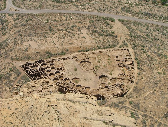
One of the most difficult parts of science communication is understanding what your audience knows and doesn’t know going in. Mark Justice Hinton recently steered me to a great blog that solves that problem with extraordinary grace. It’s Gambler’s House, a blog about Chaco Canyon, written by Teofilo, a seasonal employee at the park.

Pueblo Bonito

Pueblo Bonito

Teofilo knows a great deal about Chaco. In addition to that knowledge, by virtue of working there with the public, Teofilo’s work is informed by the things people know and don’t know when they visit the park, the questions they ask, the skepticisms they express, the things they want to know. An example, from a great piece about water at Chaco:

Looking at the remains of the great houses in the canyon today, it’s hardly a surprise that many of the most common questions visitors ask are about water.  Where did they get it?  How did they store it?  Was it wetter then than it is now?

It’s a terrific blog for a lot of reasons. The incredible insight born of listening to people’s questions is one big one.

(picture of Pueblo Bonito courtesy National Park Service)