Beyond the Cadillac Desert

Chuck Cullom, the Central Arizona Project’s Colorado River Programs Manager, asked a great question during my lunch talk last week at the Universities Council on Water Resources annual meeting. It was a panel with me and Bill and Rosemarie Alley, who’ve written a new book on groundwater that you should click on this link and buy because groundwater is really important. I’m paraphrasing badly (sorry Chuck), but Cullom wanted our thoughts on how environmental narratives had changed in the last few decades, as compared to the world in which our books now live.

Bill’s answer was brief – no one was writing much about groundwater three decades ago, he said, (or if they were got relatively little attention?) which is why books like the Alley’s are needed. But I’ve injected myself, awkwardly, into a long non-fiction literary tradition that has received no shortage of attention.

an icon

When I was a young newspaper reporter writing about Southern California water in the late 1980s, Marc Reisner’s Cadillac Desert changed the direction of my life.

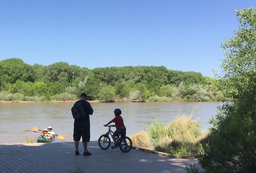
Reisner, whose book carried the ominous subtitle The American West and its Disappearing Water, tells a gripping story – a tale of skullduggery and hubris in overbuilding the great water systems that became a dominant narrative, framing the fragility of our life in the western United States. Its implicit forecast was that we were doomed to an inevitable crash. That narrative dominated my journalistic life as a newspaper reporter writing about water. First in Southern California and then for more than two decades in Albuquerque, New Mexico, I wrote about water in the sort of places Reisner was describing – improbable cities in the desert built on water imported from elsewhere, fragile, at risk of collapse.

Writing a book is an extraordinary act of hubris: “I have something to say, please spend money for it and then spend hours reading it.” The notion I quietly harbored that we needed the next Cadillac Desert, that it needed an update, and that I might write it, seemed hubris squared. It is one of the great books of the American environmental canon. Who was I?

But as drought and climate change sapped the water supplies of these great cities and the farming empires around them in the first decades of the 21st century, my journalism led me to confront a reality even more daunting – that the narrative Cadillac Desert had left us was wrong. People were not running out of water. Instead, they were adapting with remarkable grace and adaptability to this new reality. In Southern California, municipal water use in 2015 was the lowest it has been since 1991, even as population has grown 23 percent. In my hometown of Albuquerque, water use is the lowest since the 1980s. Economists call this phenomenon “decoupling” – efficiency overtaking growth. Agricultural productivity on the farms of California’s Imperial Valley, the largest patch of irrigated ground in the Colorado River Basin, is going up even as the farmers’ water use goes down.

When people have less water, I came to realize, they show a remarkable adaptability. They use less water.

This was now not simply the hubris of writing any book, or even the hubris squared of attempting a sequel to one of the great books of the American canon. I was now attempting to move Cadillac Desert, which had shaped my life, from its dominant place on the American bookshelf.

My University of New Mexico friend and colleague Melinda Harm Benson does a great job discussing the need for this transition here. Benson’s policy nerdery looks hard at the institutions that arise from the “tragedy narrative” of the likes of Reisner, arguing they are ill-suited to meet the challenges we now face. “A fear-based discourse,” she writes, “tends to have a limited shelf life and a narrow window of opportunity.”

OtPR argues that Reisner himself deserves much credit. In so powerfully pointing out our problems, she says, Cadillac Desert “rendered itself obsolete”. It is possible, invoking Benson’s observation, that the “fear-based discourse” triggered by Reisner and others had its moment and had its beneficial effect. (Not sure how we might test this hypothesis? Would this have happened anyway?) The problem now is that its narrative persists long past its best-used-by date. In much of our discourse about water in the West, a narrative of conflict and doom, of “disappearing water”, remains. On the 30th-plus anniversary of the book’s publication, it is time to both honor its contributions, but to also think hard about this new narrative.

As Eric Kuhn helpfully pointed out to me when I was in the final throes of writing the book, my critique of Reisner may have been unfair. The book’s subtitle – “Disappearing Water” – doesn’t quite match the bulk of the text. Here’s the bit I rewrote based on Eric’s comments:

In fact, Reisner concentrated his fierce critique on what he saw as a corrupt process that overbuilt the West’s great plumbing system. The subtitle notwithstanding, Cadillac Desert spends little time on the “disappearing water,” or the actual human consequences of water shortages. But neither did Reisner shy away from apocalyptic rhetoric. In the 1993 afterword to the book’s second edition, Reisner was explicit. California had just experienced what was at the time its worst drought on record, which, Reisner said, “qualifies best as punishment meted out to an impudent culture by an indignant God.”

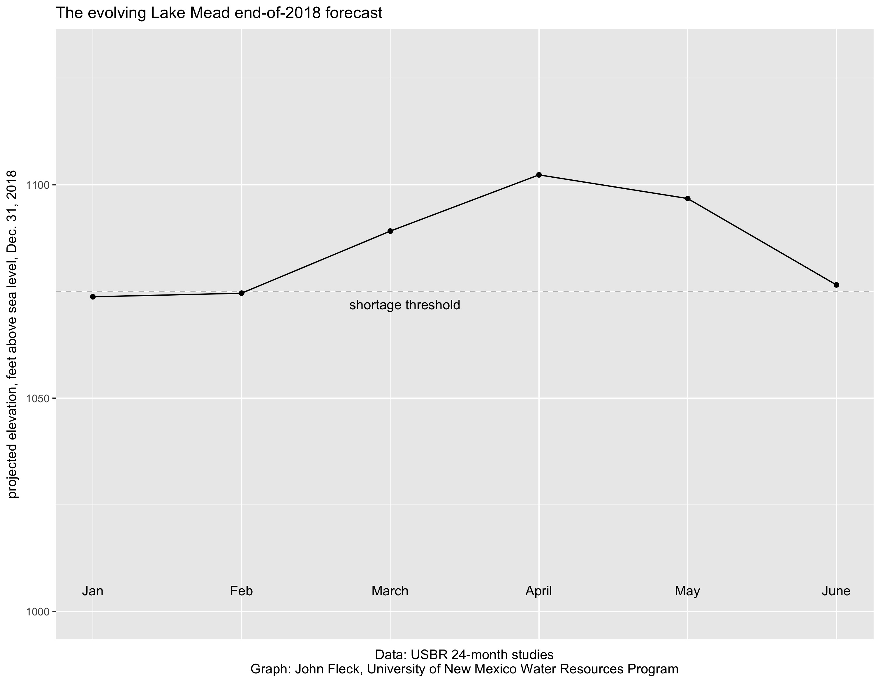
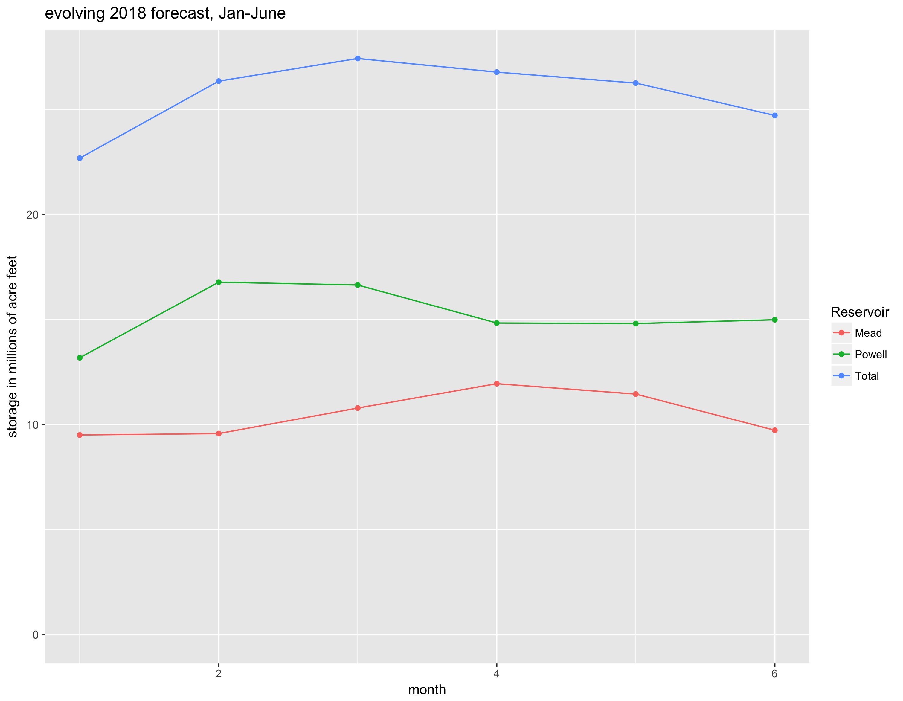
The sportswriter Andy McCullough described his writing life, to paraphrase slightly, as vacillating between unbearable arrogance and crushing self-doubt. That’s the way I felt standing at Hoover Dam watching Lake Mead drop (again and again I have done this). That’s the way I felt riding up the dry sandy bed of the Colorado River three years ago with Juan Hernandez looking for water as the Colorado River crept toward its desiccated delta. That’s the way I’ve felt for the last year as my book emerged into the world.

loss aversion and the latest Lake Mead forecast

The Bureau of Reclamation’s June Colorado River forecast projects Lake Mead ending 2018 at elevation 1,076.5 feet above sea level, three feet higher than the Bureau’s January projection of 1,073.5. If the forecast holds, that’s enough of an increase in Mead storage, thanks to a larger-than average snowpack in the Rockies, to avoid a shortage that will kick in if (when?) the big reservoir serving California, Nevada, and Arizona ends the year below 1,075.

Wait, what?

The latest Bureau of Reclamation Lake Mead forecast triggered a round of headlines in Arizona best exemplified by this: “Lake Mead Predicted to Drop 20 Feet Lower Than Anticipated”.

Holy moly, 20 feet! Which is it, up 3 feet or down 20?

the evolving Lake Mead forecast

Both.

I wish my data visualization skills were better, I really struggled with coming up with a way to illustrate the numbers. This graph shows the Bureau of Reclamation’s projected Lake Mead median elevation for the end of 2018, as it has evolved over the last six months. So the “Jan” dot is what the projection looked like in January, the “Feb” dot is an update as we got more information about the snowpack and the projection was revised, etc.

Those big bumps in March and April are the forecast models’ response to the big snowpack in the Rockies. But then it got warm and dry, the snow began disappearing, and the forecast began dropping. (As Brad Udall has been pointing out, “warm” does not fully capture what happened. Yes, Brad is right, this is a climate change story.)

I think it’s important to also think, though, about the system as a whole. Here’s a different way of looking at the data – end-of-2018 storage in Mead and Lake Powell as the forecast evolved over the last six months:

the evolving end-of-2018 Colorado River storage projections

Again you can see the forecast for Mead and Powell jumping up with the big snowpack, then dwindling as that potential big runoff turned into actual not-so-big-runoff. But it’s important to note that Lake Mead is still forecast to end 2018 226,000 acre feet above the projection made back in January, and Lake Powell is still projected to end 2018 up 1.8 million acre feet above the January projection. That’s a result of how the rules apportion water between Powell and Mead.

“Losses”, Daniel Kahneman and Amos Tversky wrote, “loom larger than gains.” This is one of the foundational principles of the field of behavioral economics. That’s what’s going on with the headlines. It felt like we had that water, and then we lost it.

But the final numbers are important. This year’s runoff has not been as big as we all hoped, but it was still enough to push projected reservoir levels up.

so much water

Eric Kuhn points out that the Colorado River in Glenwood Canyon on Colorado’s West Slope, and its major tributary here the Roaring Fork, peaked last Friday, right around the time I was up there gawking at all the water:


For a New Mexico Rio Grande guy, that’s a lot of water. But it’s actually less than currently flowing on the Green River in Utah, the main Colorado’s other big tributary.

confluence of the Colorado River, left, and the Roaring Fork, in Glenwood Springs, Colorado. Note coal train for scale.

But still, a lot of water. When I got down to the Roaring Fork, I could understand the name.

Phoenix to pay Gila River Indian Communities to leave Colorado River water in Lake Mead

The Phoenix City Council today agreed to pay the Gila River Indian Communities $2 million as part of a deal to leave 40,000 acre feet of the Indian Communities’ Colorado River water in Lake Mead this year. The state of Arizona, the federal government, and the Walton Family Foundation also are contributing. From the city staff report to the council:


Click “view the entire document” to, ya know, view the entire document.

This is a big deal along a number of dimensions. The first is simply the water in Lake Mead. This is part of a broad effort to reduce withdrawals from the over-subscribed reservoir. Still much work to do here, but evidence of progress can be found in the latest Bureau of Reclamation forecast, out yesterday (pdf), that shows Mead ending the “water year” six feet above a year ago.

Second reason it’s a big deal: outside money. The Walton Family Foundation’s contribution shows a growing role for philanthropy in going beyond governmental institutions in working the problem. This was much discussed last week at the Martz Conference I attended last week at the University of Colorado. I’m pretty sure a million dollar contribution to Colorado River system conservation is unprecedented? (Please chime in in the comments if you know of others of this sort or scale.)

The third is the partnership of the city, state, and federal government. Having those levels of government (polycentricity, y’all!) pulling in the same direction to leave water in Lake Mead is worthy of note.

The Glenwood Canyon bike path

Glenwood Canyon bike path

In Glenwood Springs this weekend, a friend kindly acceded to my demand: “We must go on a Sunday morning bike ride up Glenwood Canyon.”

It’s 16 miles of paved trail that run along the Colorado River. Like, right along the Colorado River, as you can see in the picture above. So close, in fact, that sections are closed during high water, like now – that’s about 10,000 cfs here, so we couldn’t get all the way through.

One of the great bike rides. More here.

Grand Ditch

KAWUNEECHE VALLEY – The Colorado River was flowing this morning at around 700 cubic feet per second at the USGS gauge near Baker Gulch. It felt like a lot of water – spilling the channel banks and out into the meadows, as is its way in a good spring runoff.

Rocky Mountain National Park near the headwaters of the Colorado River. The scar on the hillside is the Grand Ditch.

If you look downstream at the Colorad0 by the time the river passes Glenwood Springs, the contribution of the little tributary through the Kawuneeche Valley seems tiny – around 5 percent of the 14,000-plus cfs right now at the Glenwood gauge. But by virtue of geographical naming conventions, the “little tributary through the Kawuneeche Valley” is named “the Colorado River”, so that’s where I came to make a headwaters pilgrimage.

I’m between Colorado meetings. Thursday and Friday was the Martz Conference at the University of Colorado School of Law, a gathering of the Colorado River brain trust I try to attend every year. Next week the University Council on Water Resources is converging on Fort Collins. For the few days between, I’ve fled across the continental divide to Colorado’s West Slope to get some work done, and to do my favorite thing – wander around looking at water stuff.

One of the hardest things about mastering the nuances of Colorado River Basin water policy and politics is the nuance of intra-state conflict. I mostly work at the basin scale, where it’s easy to fall into the trap of viewing each state as a monolith, as a single blob of shared interest. At best they behave that way when it comes to working in the basin-scale governance process, but back home it’s always more complex.

Here in Colorado, the important nuance is the West Slope-Front Range tension over trans-mountain diversions – moving water from the west side of the continental divide to the east. The “Grand Ditch” (so named because the Colorado was then named the Grand River here) is one of the earliest large such diversions, built in the 1890s to take water from what is now the Never Summer Mountains and deliver it by gravity flow across La Poudre Pass for farmers on Colorado’s east side.

That gash across the mountainside in the picture above is the Grand Ditch.

courtesy Northern Water

With all due respect to my friends at Northern Water, the plumbing up here is absolutely crazy.

The Colorado here flows into Grand Lake, which they expanded with the construction of Shadow Mountain Dam. They drilled a tunnel out of the bottom of Grand Lake, under Rocky Mountain National Park and the continental divide, to deliver water to Northern’s system.

But wait. There’s more. Just downstream of Shadow Mountain is Lake Granby, created by the construction in the 1940s of Granby Dam. Grand/Shadow Mountain don’t have a lot of storage, so they built Granby to add to the system’s storage capacity. But Granby is downstream of Grand Lake and the tunnel. So water is pumped back upstream when it’s needed.

But wait. There’s more. Downstream from that is Windy Gap Reservoir. Which expands the storage a bit more. When it’s needed, Windy Gap’s water is pumped back uphill to Granby. But if Granby is full? See Windy Gap Firming Project.

But wait. There’s more. Green Mountain Reservoir is my favorite piece of this crazy system, because it illustrates the complex institutional tensions that arose when folks on the east side of continental divide began increasing their trans-mountain diversions. Green Mountain is a sort of compensation for lost water. It provides storage of early runoff to keep Colorado River flows above Kremmling higher during the summer months when the river would otherwise drop because of the diversions from all the plumbing upstream. Added storage for West Slope use was part of the grand compromise for the trans-mountain diversions folks east of the continental divide wanted.

Click on the embedded map for a link to a high-res pdf of the rest of the system, courtesy of Northern Water. Because yes, there’s more.

All of this storage and tunneling and pumping is based on the idea that during the peak of spring and summer runoff, there’s lots of water. Stored and then moved to other places, it provides benefits. But it also is worth noting that were it not stored, pumped, tunneled, diverted, it would flow downstream where both human users and natural systems (“rivers”) await. Hence the importance of understanding the nuances.

The argument in Colorado has always been between those who viewed the economic potential and therefore the value of the water as being far greater along the Fort Collins to Pueblo “Front Range” corridor, versus folks on the west side who so keeping that water as central to their communities’ future. On the West Slope water is, to borrow from the historian Steven Schulte, “as precious as blood“.


the Colorado River

As climate warms, a decline in snowmelt runoff

Based on hydrological model simulations and a new snowmelt tracking algorithm, we show that 53% of the total runoff in the western United States originates as snowmelt, despite only 37% of the precipitation falling as snow. In mountainous areas, snowmelt is responsible for 70% of the total runoff. By 2100, the contribution of snowmelt to runoff will decrease by one-third for the western U.S. in the IPCC RCP8.5 scenario. Snowmelt-derived runoff currently makes up two-thirds of the inflow to the region’s major reservoirs. We argue that substantial impacts on water supply are likely in a warmer climate.

Li, D., M. L. Wrzesien, M. Durand, J. Adam, and D. P. Lettenmaier (2017), How much runoff originates as snow in the western United States, and how will that change in the future?, Geophys. Res. Lett., 44, doi:10.1002/2017GL073551.

Albuquerque, y’all

A Sunday morning on Albuquerque’s Rio Grande

People, this is right in the middle of my town. Right in the middle.

New riding and walking trail along the Rio Grande in Albuquerque

This is about half a mile from where I took the last picture, up a new riding and walking trail just north of the old Route 66 bridge right in the middle of Albuquerque.

Near the Rio Grande Nature Center, Albuquerque

The river’s up this year, it was a great day to wander Albuquerque’s riverside. I mean, this is right in the middle of Albuquerque.

Desalination and water’s scale issue

A sometimes poorly understood piece of the water story is the question of scale – the truly enormous quantities of water required to do human stuff like be a city or grow our food.

This is the shortcoming of well-meaning suggestions like building a pipeline to the Missouri River or a string of desalination plants along the coast, or a string of desal plants that connect up with big pipelines criss-crossing the country.

Writing in the San Jose Mercury-News last week, Stanford’s Leon Szeptycki and Newsha Ajami gave a nice explanation of the problem in the context of California’s ever-present desal discussion:

We withdraw approximately 42 million acre-feet per year from rivers, streams, and aquifers in California. We use up a net total of 33 million acre-feet of that. According to the 2013 update to the state’s water plan, even if every proposed ocean desalination facility were built (an unlikely scenario), they would produce a combined total of approximately 382 thousand acre-feet a year, less than 1 percent of the state’s existing water budget.

This doesn’t mean that desal does not have a place at the margins, in niches where there is no good alternative. But in general the scale of our water use is far too vast to have any impact on the overall problem.

#tbt – Dorothea Lange in the dry lands of eastern Oregon

“New farm in Cow Hollow, Malheur County, Oregon. Note basement dugout house and excavation for new house in foreground.” Dorothea Lange, 1939, courtesy Library of Congress

Some day I’m going to find an excuse to write – I mean really write – about Dorothea Lange.

One of my favorite Internet rabbit holes is the Library of Congress photo archives, and one of my favorite sub-rabbit holes there is the work of Dorothea Lange.

For much of the 1930s Lange, working for the Resettlement Administration and then the Farm Service Administration, photographed rural American poverty. Much of our common public understanding of the depression and its impacts on rural America (they also shot urban poverty, but their most powerful work was of rural communities) comes from the iconic imagery of Lange and her FSA colleagues. Lange’s “Migrant Mother” is one of the great works of the American canon.

There’s something deeply uncomfortable about the work for a couple of reasons. The first is the raw intimacy with which Lange shows poverty. Some of them make me wince. You’ll notice my choice of picture for this post – not one of Lange’s burning close-ups.

The second is the way in which our government funded the creation of the imagery, which it made freely available, as part of an effort to build public support for policies that were in  some ways controversial. Lange and her FSA colleagues were not traveling randomly. They were visiting places served by FSA and other federal programs. The picture above if from a Lange trip documenting the US Bureau of Reclamation’s Owyhee Project, delivering Snake River water to farms in eastern Oregon. There is a huge body of FSA work documenting the benefits of federal irrigation as the Resettlement Administration and subsequent federal programs attempting to develop new agricultural communities for those driven out of the Midwest by the Dust Bowl. Side by side with their more famous and powerful work are many FSA pictures of irrigation works. Dorothea Lange was at her best photographing people. Her plumbing work – meh. I am uncomfortable with the implication that this amazing body of American art was funded by and used as tool of government propaganda.

Both of those reasons for discomfort interest me enormously. Because the pictures are amazing, a remarkable body of work capturing a remarkable moment in time.

“Franklin Schroeder, from South Dakota, and his two older boys. Dead Ox Flat, Malheur County, Oregon.” – Dorothea Lange, 1939, Courtesy Library of Congress