I’m fascinated by the geomorphic traces left by the rise and fall of Lake Mead – human scale (egret scale?) shoreline terraces. This is on the northern bank above Boulder Harbor. The bird, shown for scale (I don’t have a rock hammer, it’s a great egret, so quite large), hangs out there because of the fisher people.
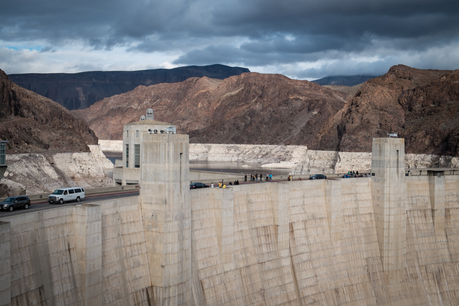
Lake Mead “bathtub ring”
One of the members of my brain trust was speculating idly the other day about how different the Colorado River dialogue might be if the hydro-geo-chemistry of the bathtub ring was different – if the dropping water didn’t leave a white mark, letting you see how much Lake Mead has dropped, letting people like me take a picture to put on my blog.
Standing atop Hoover Dam last week, I heard one of the Bureau of Reclamation tour guides emerge from the elevators, pointing out the bathtub ring and saying:
I don’t think as long as I live I will ever see it get to the top again.
I’m sure he or she does not speak for the Bureau and the Secretary of the Interior on this sensitive point.
Rio Grande forecast improves, but that’s not saying much
update, Thursday, 3/5: Final March 1 forecast numbers are in, unchanged for those in the preliminary quoted below.
previously: It says something about the drought on New Mexico’s Rio Grande in recent years that a forecast of 67 percent of average runoff into Elephant Butte Reservoir is good news.
That’s the mid-point of the preliminary forecast sent around to New Mexico water managers and stakeholders today by the Natural Resources Conservation Service. The forecast includes the early March storm, which has pushed snowpack to 87 percent of average in the Rio Grande headwaters of Colorado and near normal in the mountain watersheds of northern New Mexico that feed the river. But as you head south, the numbers drop, and the forecast reflects that.
There’s still a big spread of uncertainty in the forecast, with a lot riding on what happens in March:
- wet (the 3 in 10 high-flow probability): 92 percent or above
- mid: 67 percent
- dry (3 in 10 low flow probability): 41 percent or below
This is the fifth consecutive March 1 for which the forecast has been below-average bad news at San Marcial, the gauge at the head of Elephant Butte Reservoir, a point I’m calling out here because the greatest drought impact has been on farmers who depend on water from Elephant Butte. After flush years in the ’80s and ’90s, irrigators drained the Butte in the first decade of the 21st century. As I wrote a couple of wrote a couple of years ago in the newspaper:
Yields are already down – 30 percent in the case of onions, one of the valley’s money crops. A drive through the valley shows tiny spring onion plants already stunted by the salt accumulating in the soil beneath them.
As for chile, Shayne Franzoy said the Hatch Valley should have a decent crop this year for the packers, like Bueno Foods in Albuquerque, that depend on their chile. But if drought conditions continue, the future is less certain. “If we don’t have surface water in the Hatch Valley,” Jerry Franzoy said, “it’s gonna die pretty quick.”
That was two years ago. It hasn’t gotten better.
AMACRQ: How do you pronounce “CAP” and “SNWA”?
The latest edition of Inkstain’s infrequent* Ask Me a Colorado River Question feature comes via Paolo Bacigalupi, and it wasn’t quite phrased as a question, but I’m hoping to resurrect the feature.
I’ve always said “cap” for CAP and “snee-wah” for SNWA. But I have no idea why. Odd and embarrassing. @jfleck @waterwired @jonnypeace
— Paolo Bacigalupi (@paolobacigalupi) March 4, 2015
My answer was that I say, and hear others say “cap” for the Central Arizona Project, but I’ve always stumbled over SNWA and usually just say “Vegas” which seems inadequate. Or sometimes “Southern Nevada,” which also doesn’t quite get the thing done.
What do you, dear readers, do with these two initialisms?
* I think it’s appeared, like, once.
How low can municipal water conservation go?
From Gary Woodard’s work – in Arizona…
an annual drop in per-household demand of more than 2 percent between 2000 and 2013 across Maricopa and Pima counties.
This trend is expected to extend through 2020, as we continue to replace appliances, fixtures, and landscape plants with new, more water-efficient ones; construct new, more water-efficient homes; and participate in water conservation programs offered by municipal providers.
Hoover Dam, sunset
April-July Colorado River runoff: 71 percent
With a dry February, the chances of a big snowpack and “bonus water” flow in 2015 that might begin to refill Lake Mead and Lake Powell are just about gone.
April-July runoff into Lake Powell, the big reservoir in the Colorado River’s “Upper Basin”, is forecast to be 71 percent of average, according to the Colorado Basin River Forecast Center. There’s still a one in ten chance, if things get wet over the next month, that we could have an average year. But with another lost month, the chances on the wet side of the probability distribution no longer leave much room for enough excess runoff to bail out the river system’s shrinking reservoirs.
On the bad side, the “one in ten” forecast on the dry side, the worst case scenario, is for 48 percent of average.
As you can see from the map to the right, February was wet up in the state of Colorado, but if your interest is in Colorado River runoff, it was not wet in the right places. That blue blob is on the eastern slope and the plains. The high mountains and west slope were drier than normal, which translates into less runoff into Lake Powell.
I’m waiting on more New Mexico numbers (the Rio Grande Basin) and will write a separate post when I get them, but the preliminary numbers in the San Juan headwaters, which provides San Juan-Chama water, are not good. The projected flow at the Navajo/Chromo/Oso measurement point in southern Colorado, a good proxy for overall SJC production, is 58 percent.
(Full disclosure: I foolishly entered into a bet regarding April 1 SJC supply. It’s a complicated bet involving total allocated and in storage on April 1. Suffice to say I have a cost-of-a-dinner incentive to root for more snow. Also, it’s my community’s drinking water supply.)
West’s snowpack improves, still not great
It is testimony to a lousy January and most of February that the spectacular snowstorm I drove home into over the weekend left the key watersheds that provide water to the Rio Grande and Colorado River still behind average for the year. The 9 inches of snow at my house was the most since December 2006, and snow was widespread across northern New Mexico and into Colorado:
Two key basins I watch in southern Colorado – the San Juan and the Upper Rio Grande, are still well behind, but have gone from potentially disastrous (below 60 percent) to simply bad (72 and 86 percent respectively). In New Mexico, the Sangre de Cristos and Chama area are both above 90 percent, which is enough to earn green on the map.
The broader measure of interest to the West, the Colorado River Basin, has climbed as a result of the storms, with steady improvement for the last week, but is still well below average for this time of year. We’ll get formal forecasts later in the week, but the automated daily computer runs are projecting runoff above Lake Powell (the broadest measure, averaging across all the watersheds that feed the San Juan, Green and Colorado rivers) of 72 percent of the long term mean.
(Thanks to Kerry Jones at the National Weather Service in Albuquerque for help with the maps.)
Call for abstracts, Upper Colorado River Basin Water Forum
The folks at Colorado Mesa University have sent ’round their call for abstracts (pdf) for this fall’s Upper Colorado River Basin Water Forum:
(Disclosure: I’m on the forum planning advisory committee.)
In the mountains of southern Oregon, what used to be snow turns to rain
Precipitation this winter at Crater Lake, in northern California southern Oregon, is a tad above normal. Snowpack is at record lows:
On Friday morning, the snow level was at 32 inches, tying the Feb. 27 record for low snow. However, snow was falling Friday from a new storm system bringing rain to the Rogue Valley and snow to higher elevations.
Grimes said the park is actually at 104 percent of its average precipitation for this time of the year. But warmer temperatures have caused much of that moisture to fall as rain rather than snow.