Stuff I wrote elsewhere: Albuquerque water managers think we’ve conserved enough

From the morning newspaper, a column about the assumption embedded in Albuquerque’s water utility budget – that Albuquerque water conservation has hit bottom:

[T]he Albuquerque Bernalillo County Water Utility Authority’s latest spending plan bets you’ve finally hit the conservation wall, projecting that from the current 134 gallons per person per day, you’ll go up to 135 next year. That’s an extra 250 million gallons over the course of the year.


Arizona water managers warn Lake Mead could be sorta unusable in five to eight years

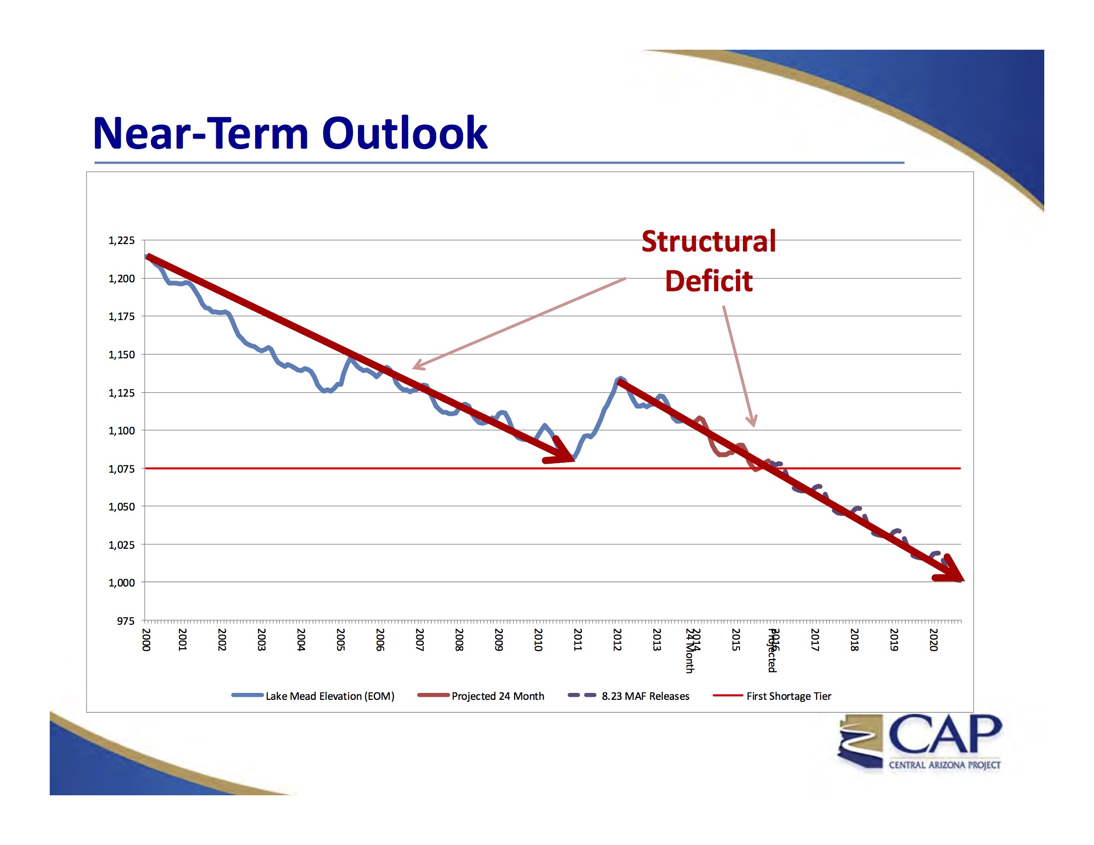
Near Term Lake Mead Outlook, courtesy CAP

Near Term Lake Mead Outlook, courtesy CAP

update: see also Part II, discussing Arizona’s suggestion regarding what it might take to fix this problem

Absent some big wet years or management intervention, Lake Mead could drop to levels in the next five to eight years that would make it nearly unusable – especially for power generation and water for Las Vegas, but also at some risk for other downstream users – according to a presentation last week by staff at the Central Arizona Project to the agency’s board of directors.

That five-to-eight year time frame is how long it might take, under the scenario sketched by CAP staff, for the surface elevation of Lake Mead to drop to 1,000 feet above sea level – like Four Minutes to Midnight on the Colorado River Doomsday Clock or something. It’s still not midnight, but scary close.

The problem is not drought, though drought makes it harder to dig out of the hole now being created. Rather, it is a “structural deficit,” according to the presentation by the CAP’s Tom McCann and Chuck Collum. The Lower Colorado River Basin’s full legally required allotment each year from the Upper Basin – 8.23 million acre feet – is not enough to meet all the Lower Basin’s water needs. Only with periodic infusions of what I’ve been calling “bonus water” – extra water during unusually wet years – can the Lower Basin make ends meet.

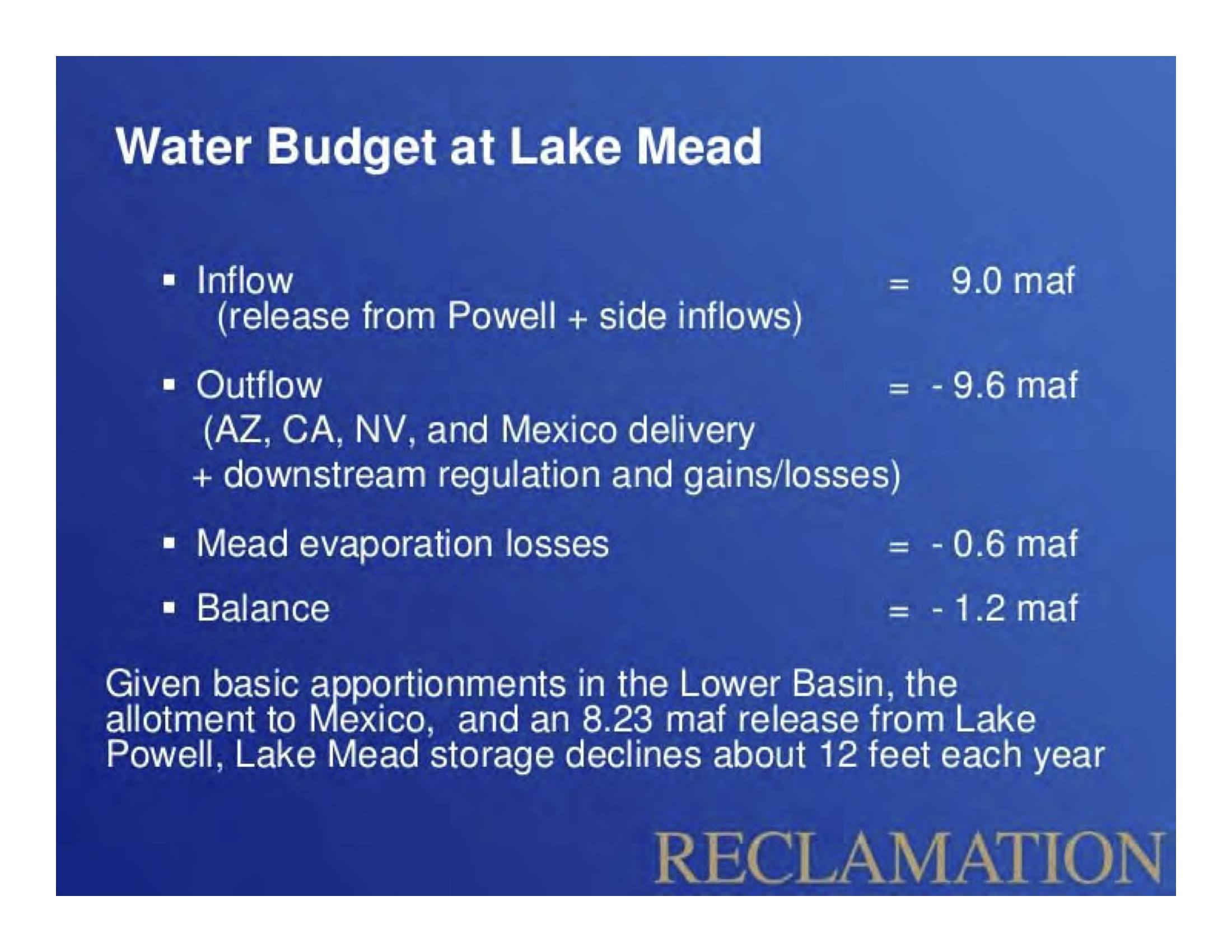
Lower Basin Water Budget, courtesy USBR

Lower Basin Water Budget, courtesy USBR

The basic deficit spending math is not new. (See for example Why is Lake Mead Dropping from four years ago or my personal favorite, Hookers and Blow on the Lower Colorado.) What’s new is to hear the analysis of the problem and its dire implications come in the form of a stark public warning from the staff one of the most important water-using agencies in the Lower Basin. This is not some snarky blogger talking. This is coming from the number crunchers at CAP.

I first saw the key math involved in the Lower Basin water budget at a reservoir management meeting in Las Vegas back in the spring of 2010, but the numbers have been around for longer than that. It was a talk by Paul Miller, who then worked for the USBR, and he used exactly the same slide as the one to the left – the slide used in the CAP presentation last week. The math is really simple – a full delivery into Lake Mead is about 9 million acre feet, while evaporation is 0.6 million acre feet and downstream requirements are 9.6 million acre feet.

That’s a 1.2 million acre foot “structural deficit” that’s only made up for when there’s extra water above and beyond the Colorado River Compact’s required deliveries.

That graph at the top shows Lake Mead dropping in 12 out of the last 15 years despite the fact that the big reservoir has gotten its full allotment every single year. That’s the structural deficit.

So what happens if nothing is done and Mead hits 1,000 feet above sea level? A couple of the impacts are the results of physical constraints on the system.

  • Regardless of how much water it might be entitled to on paper, Las Vegas has a hard time physically getting its water out of Lake Mead, which supplies ~90 percent of the metro area’s water (though Vegas is hustling to engineer its way out of that problem with a new, deeper intake)
  • Generating electricity gets increasingly difficult below 1,050

Beyond that, if nature (in the form of unusually wet years) or the federal government (in the form of intervention to conserve before Mead hits the breaking point) doesn’t intervene, the CAP analysis suggests we’ll be left with what water managers call “run of the river” operations – the only water available each year is the water nature provides. Hoover Dam could be used to smooth out the timing a bit, holding during high flow times of year to deliver water during low flow times of year. But in terms of year-to-year storage, it would be almost like we don’t have a dam at all.

Here’s the full CAP slide deck:


download a copy

How we use water in the desert

Hay bales at Valle do Oro in Bernalillo County's south valley, June 2014

Hay bales at Valle do Oro in Bernalillo County’s south valley, June 2014

In 2012 cattle, calves and dairy made up 78.6 percent of New Mexico’s farm receipts. Hay to feed them was the next-largest component of the state’s ag economy at 4.3 percent. Pecans were next at 2.7 percent, and our famous chile made up 1.6 percent of farm receipts.

Source: USDA ERS

In the background, you also can see some cottonwoods.

The L.A. River – when “wasted” water isn’t wasted

It seems like a no brainer.

Stop wasting that water! Put it to good use! But when we’re talking about things like lining irrigation canals (see for exmample the All-American Canal saga, pdf here) or cleaning up and re-using sewage, it’s critical to ask the question: If we don’t do this, where will that water end up?

Two city agencies are drafting a new proposal to purify treated sewage and refill the groundwater basin, where wells would pump it up, eventually leading to the taps of homes and businesses.

Right now that very same treated water that used to be sewage flows into the Los Angeles River from a Van Nuys plant. Under this new plan, much of it would instead be pumped into the ground, leaving the river’s water levels substantially lower.

“Maybe 60 years from now we won’t be kayaking on the river,” said Council for Watershed Health program director Mike Antos, who leads the Los Angeles Basin Water Augmentation Study.

“We’ll be mountain biking.”

That’s Mike Reicher in a smart story in the L.A. Daily News looking at the dilemma of sewage reuse in Los Angeles.

The value of steps like lining an irrigation canal or reusing sewage depends entirely on where the “wasted” water was ending up before we tried to fix whatever problem it is we think we’re fixing.

The U.S.-Mexico border as arbitrage

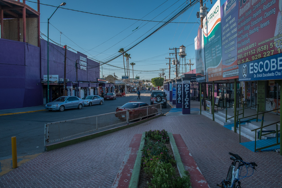
Los Algodones in the morning, looking south from entry gate, March 27, 2014

Los Algodones in the morning, looking south from entry gate, March 27, 2014

As you exit the pedestrian gate at the U.S.-Mexico border crossing at Algodones, you find dentistry, a pharmacy and cheap liquor.

In other words, the international line created a sharp gradient, over which money from Northside accordingly spilled; and Mexicans came from all over Southside to be nourished by that money.

– William T. Vollman, Imperial

Phoenix: population up, water use down

Phoenix is following a pattern I’ve frequently noted here – water conservation is, at least for now, outpacing population growth:

Research by Phoenix’s Water Service Department shows 1.5 million people lived in Phoenix in 2013, and about 375,000 homeowners had city water accounts. In 1998, about 1.2 million called Phoenix home, and 301,475 had water accounts. (Apartments and townhouses were not included in those numbers.)

Residential water use totaled 159 million gallons per day in 2013, down from 169 million in 1998, according to Gerard Silvani, a principal planner for the department.

That’s 25 percent population growth, 6 percent water use decline.

What is water?

We have revolutionized our concept of what western water is. It is no longer simply a commodity to be removed from a watercourse for use on farmland or in a factory. There is life and beauty in water. It is a valid use of water simply to allow it to remain in a stream or lake. In a sense, after first rejecting the riparian rule so resoundingly, we have reconsidered and have reached a deeply held consensus that there is undeniable merit in some aspects of riparianism: sufficient water absolutely must be available to meet a broad range of public environmental, recreational, ecological, and aesthetic needs.

– Charles Wilkinson, Western Water Law in Transition, 1985

In western water, what’s the right role for the feds?

After spending the day reading about the federal government’s, shall we say, persuasive role in assisting Imperial Valley farmers that it was in their best interests to figure out a way to share a bit of their water across San Gorgonio Pass with the city folk to their west, I this evening ran across this:

Reed Benson, a professor at the University of New Mexico School of Law in Albuquerque, said states need what he called a gorilla in the room, and federal money, to reach agreements.

“Federal money has been, and is today, important in addressing challenges with water resources where the deep pocket is needed,” Benson said. He cited the need for parties to cooperate and compromise on issues affecting water basins stretching across several states, questions about tribal water rights, and overarching concerns about water quality and quantity.

“Finally, climate change is going to make these issues all the more difficult and that much more challenging,” Benson said.

I’m not sure that’s quite the way the gorilla behaved in the Imperial Valley in the period from the 1980s to the early 2000s that led to the still unhappily lurching Quantification Settlement Agreement. At times it sounds a bit more like, “Nice valley ya got here, Imperial. Shame if something was to happen to it.” But the gorilla was relatively important.

In British rivers, pollution control seems to be working

Pollution control efforts seem to be working on Britain’s urban rivers:

Britain’s urban rivers are the cleanest they have been for more than two decades, a study has found.

More than 2,300 river sites in England and Wales were analysed between 1991 and 2011 by Cardiff University.

They examined the presence and spread of 78 organisms – including insects, snails and others – and claim many are making a comeback following decline.

The scientists say the improvements are largely due to reductions in pollution levels.

I learned of this via the always helpful Circle of Blue’s The Stream.

That thing I wrote about Lake Mead being the lowest ever turned out to be true

If I wanted to make mischief, I’d write a blog post pointing out that Lake Mead ended May at a historic low right after release of 105,392 acre feet of water for a historic environmental flow through the Colorado River Delta. I’d calculate how much higher Lake Mead would be if that 105,392 acre feet of water was still sitting in the big reservoir behind Hoover Dam, ready to serve the needs of Las Vegas or the farmers of the Imperial Valley. But that would be a sneaky, mean thing to do. It also would be misleading, and the reasons illustrate one of the central themes I’m arguing in the book I’m writing. You can’t look at any one piece of Colorado River management in isolation.
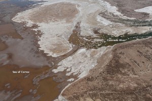
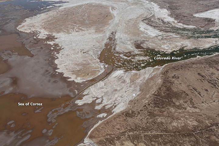
Colorado River "pulse flow" reaches the sea. Image courtesy of Sonoran Institute/NASA

Colorado River “pulse flow” reaches the sea. Image courtesy of Sonoran Institute/NASA

Yes, Lake Mead ended May at elevation 1,087.45 feet above sea level (or maybe 1,087.46?) the lowest end-of-May level since 1937, when the reservoir was first being filled. (The USBR web site is having problems, I’ll try to come back and add links later, sorry.)

Yes, that’s lower than it would have been had the Minute 319 environment pulse flow not been carried out this year.

But there’s more to the story.

In mid-May, the USBR released its annual “Colorado River Accounting and Water Use Report,” a tome of tiny print that explains why it would be sneaky and mean to write such a blog post as I described above. On page 24, the report points out that since 2010, Mexico has stored 294,067 acre feet of water in Lake Mead, including 126,812 acre feet of “deferred delivery” water during calendar year 2013. Colloquially, they call this “earthquake water” – water stored initially under an agreement in the fall of 2010 that for the first time allowed Mexico to store water in Lake Mead for later use. The proximate cause was a spring 2010 earthquake that damaged water delivery infrastructure in the Mexicali Valley. The resulting agreements for the first time allowed Mexican Colorado River water to be stored in a U.S. reservoir. Big breakthrough.

The 105,392 acre feet used for the pulse flow is part of that 294,067. Without “earthquake water”, Mead would be even emptier.

But it’s an even richer story than that. Minute 319 and the environmental pulse flow made for some great photo ops, but there is much more being done. The water use report documents a number of steps taken by U.S. water agencies to buffer Lake Mead’s contents through “Intentionally Created Surplus,” a mechanism established in 2007 that allows water agencies storage credit for water conservation steps they take back home that allow them to reduce the amount of water they need to divert. The accounting shows more than a million acre feet of ICS water in Mead right now. Without a closer look at the accounting, I wouldn’t swear that that is real wet water in Lake Mead, but some portion of it clearly is.

For Southern California right now, this is crucial. The Metropolitan Water District ended 2013 with 474,063 acre feet of ICS water, some of which it plans to draw down in 2014 to make up for shortfalls in in-state water deliveries because of California’s epic drought.

Will this be enough? I don’t know, that’s why I’m writing a book. But it’s not nothing.

The bottom line: LAKE MEAD AT HISTORIC LOW is cheap and successful clickbait, and it would be easy to point to the recently completed environmental pulse flow and arch my eyebrow at such a use of precious water at a time when the Colorado River system is on the edge. But that would be sneaky and mean and misleading.