
So Pablo Picasso, Frank Lloyd Wright and Miles Davis walk into a bar….
Does water really flow uphill toward money?
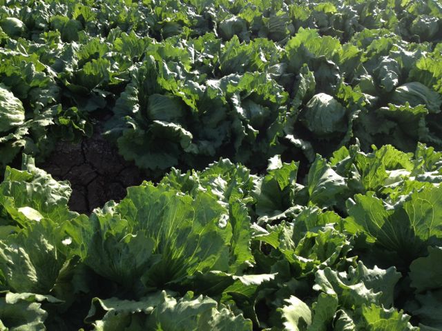
Lettuce being grown with Colorado River Water, Yuma AZ
There’s a truism in water politics and policy in the western United States that “water flows uphill to money”. But is it correct?
I ran across it most recently in an excellent editorial in the Salt Lake Tribune regarding the Southern Nevada Water Authority’s proposal to build a pipeline to rural Nevada, along the Utah border, to ferry water to Las Vegas. The Tribune editorial board makes a reasonable point – that once folks in Vegas spend all that money to build a pipe, it may be difficult to enforce regulations designed to throttle back the pumping if it looks like it’s harming the “move from” area:
But experts rightly caution that by the time the wells sound the alarm, it could be too late to reverse the damage. Besides, once Las Vegas has invested in a $3 billion pipeline and pumping system, it will not give up the water willingly. In the West, water inevitably flows toward population and money.
As I said, I think it’s a reasonable concern. But is the inevitability described in the last sentence really the case? I’m inclined to think that, in the West, water flows uphill to money, except when it doesn’t.
There are good examples, especially in California, where water is quite literally flowing uphill toward wealthy water users. I’m thinking here about the agricultural users in the western San Joaquin Valley and the urban users of Southern California, who draw heavily on the troubled Sacramento-San Joaquin Delta for their water supplies. They appear willing and quite able to use their wealth and influence to move water to meet their needs.
The Cadiz project in California also appears to have a lot of the “uphill to money” characteristics.
But there are counter-examples. I’ve written in the past about cases in New Mexico, most notably the big Augustin Plains proposal (a lot like Cadiz or Snake Valley in Nevada) where state water law has thus far blocked efforts to pump water “uphill to money”. In fact, as Bettina Boxall wrote last week in the LA Times, it’s not entirely clear that money will be sufficient to move the Cadiz water along its very uphill journey.
And my favorite example, as I’ve written about at some length, is the federal government’s decision back in 2003 to cut LA’s allocation of Colorado River water. That was a decision against shipping water uphill to the wealthiest on two counts. First, on an interstate basis, it represented a decision to cut wealthy California’s overall allocation of Colorado River water in deference to the other less wealthy and politically powerful states in the basin. Second, within California, it represented a decision to cut wealthy urban-suburban Southern California’s water supply while preserving the water rights of less affluent and less politically powerful Imperial Valley farming interests.
In the latter examples, legal structures to manage water rights held firm under the pressure of wealthy and powerful interests that would have preferred to move water “uphill to money”. So what are the characteristics that distinguish between the two outcomes?
Sewage as an asset
Increasingly, around the United States I see more and more of this sort of story, in which agencies view sewage as an asset:
Kenner is seeking state and federal permits to build a 2-mile-long pipeline carrying 17 million gallons of treated sewage a day* into the LaBranche Wetlands. The goal is twofold: Help restore the marsh, and give Kenner a second discharge route from its overburdened treatment plant.
Via Drew Broach at the Times-Picayune
* For those wanting a translation into other uselessly arcane non-metric units, that’s 26 cubic feet per second
“beneficial reduction”
Re my recent discussion of the of the concept of “beneficial use” in western water law, a friend attending a water conservation conference noted he’d run across the concept of “beneficial reduction”.
What, in legal terms, might that look like?
How’s that whole “El Niño” thing workin’ out for ya?
Here in the Southwestern United States, we loves us some hot, hot El Niño action. Warm up that equatorial Pacific, and before you know it, ZAM, we’re being pelted with snowflakes and having to shovel our driveways with those wussy regular shovels desert dwellers use. (True story: I actually have a real snow shovel. Lissa bought it for me a few years ago. I tried to use it once, but I felt really silly. There was very little snow.)
The current Climate Prediction Center outlook does not look promising for my shovel. After seeing signs of a brewing El Niño, the CPCers are now trotting out the dreaded “neutral” word:
Compared to the past few months, the chance is reduced for El Niño to develop during Northern Hemisphere fall/winter 2012-13 (see CPC/IRI consensus forecast). Due to the recent slowdown in the development of El Niño, it is not clear whether a fully coupled El Niño will emerge. The majority of models indicate that borderline ENSO-neutral/ weak El Niño conditions will continue, and about half suggest that El Niño could develop, but remain weak (Fig. 7). The official forecast therefore favors the continuation of borderline ENSO-neutral/ weak El Niño conditions into Northern Hemisphere winter 2012-13, with the possibility of strengthening during the next few months.

Hookers and blow on the Lower Colorado – boring wonky back story
First, my apologies to Michael Campana, for whom my recent disquisition on hookers and blow on the Lower Colorado seems to have caused some inadvertent difficulties. I expect my Texas neighbors are the forgiving sort and will welcome you back. It would be unfortunate, given their recent difficulties with the whole running-out-of-water thing, if they were to cut themselves off from access to such a wise water policy sage.
Second, to my friends in the Lower Basin, I must apologize. As Emily Green wisely noted in the comments, who am I to judge whether hookers and blow are or are not a beneficial use of water?
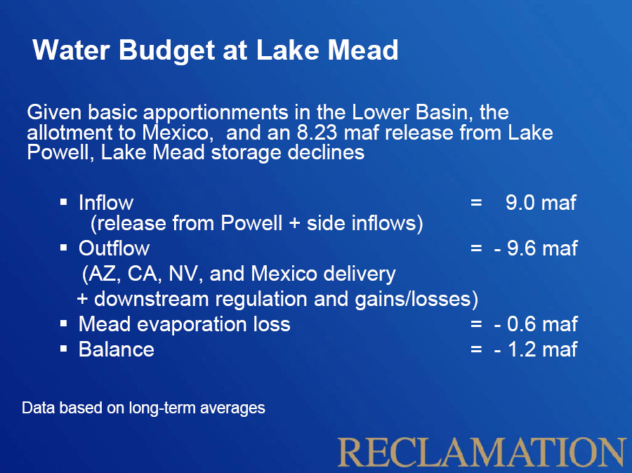
Lake Mead water balance
Also, I had this fancy spreadsheet I’ve been working on, with graphs and stuff, explaining the core problem – that, given its legal annual entitlement, without any “bonus water” resulting from either underuse or surplus supplies in the Colorado River’s Upper Basin, the Lower Basin is inevitably going to drain Lake Mead. But that’s wonky stuff that you’ve heard before (and here and here and here). There simply is no alternative, given the current approach to managing the river, to that reality. As the accompanying Bureau of Reclamation slide notes:
Given basic apportionments in the Lower Basin, the allotment to Mexico, and an 8.23 maf release from Lake Powell, Lake Mead storage declines
Recall that the long term supply and demand curves in the Colorado River Basin crossed some time in the late 1990s, and in the years since the states of the basin have been meeting their water needs by draining the reservoirs behind Glen Canyon and Hoover dams. Since 1999, the total water in storage behind the two big dams has decreased by 20.5 million acre feet (I think that’s 25.2 billion cubic meters, Andy).
More importantly for water management purposes, the total water in storage in Lake Mead, the savings bank to meet water needs in Nevada, Arizona and California, has declined by 11.5 million acre feet since 1999, despite the fact that in each and ever year the Upper Basin has met its legal requirement to deliver 8.23 million acre feet past Lee’s Ferry. Recall that under the Law of the River, we’ve sorta agreed to split this river at Lee’s Ferry, so it’s not entirely clear that we’re all in this together. As long as we Upper Basin people keep hitting that 8.23 maf target, y’all are on your own down there, I fear. Under the current situation, bonus water is a possibility in many years, but the Lower Basin can’t count on it forever.
I’ll roll out the fancy graphs next week, when I get the final water year numbers. But the wonky stuff never draws big web traffic, so, in the meantime, if nothing else, hookers and blow and the f-word sure got a lot of clicks!
That Austin streamwater ain’t comin’ from nature
An intriguing paper from some folks at UT Austin, looking at the isotopic composition of water in Austin-area streams. Turns out that the natural source water in the area has very different strontium ratios from the imported municipal water brought in from their Colorado River:
In the more urbanized watersheds, Sr-isotope mass balance indicates that ~ 90% of base flow is composed of water from anthropogenic sources.
Where’s it coming from?
1) leakage from the sewage system, 2) leakage from the water supply system, or 3) irrigation (e.g. lawns and gardens).
Thanks to Kevin Anchukaitis for pointing me to the paper.
Time for a Lower Basin New Year’s resolution?
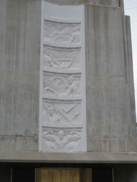
Flood control, navigation, irrigation, water storage, power: Hoover Dam, December 2011
Hey Lower Colorado River Basin. Can we talk?
I know, I know. It’s New Water Year’s Eve and it’s like a hundred something degrees and sunny and you wanna go water skiing on Lake Mead, all fat and happy with its 1,115.18 feet of surface elevation, glistening in that warm Nevada sunshine. Or you wanna grow some lettuce or something. I get that you have stuff to do. But really, we need to talk.
I just wanna point out that Lake Mead has less water in it today than it did when the last water year ended. I know, I know, it’s only a tiny bit less. But the thing is, we Upper Basin folks gave you a bunch of extra water again this year. How could Lake Mead be down?
I understand that rules are rules and a deal’s a deal. We agreed that when we have more water up here in Lake Powell than you do in Lake Mead, we’d send some of the extra your way. The law says we really only have to give you 8.23 million acre feet of water each year, but OK. Since Powell was looking a little flush, we sent you 9.463 million. That’s what the operating agreement says and, as I said, a deal’s a deal.
It’s just that, between drought and all the extra water we sent you, Powell’s down 3.6 million acre feet this year. That’s 1.2 million extra acre feet of water we sent your way this year, for chrissakes, while Lake Powell dropped 30 feet!
I hate to go all “big brother with his math” on you, but here’s the reality: Since 2000, we’ve sent you 6.3 million acre feet above and beyond the amount you can legally expect to get every year in the long term – the 8.23 million acre foot minimum release from Lake Powell each year under the Law of the River. During that time, when we’ve been giving you all that extra water, Lake Mead has dropped 80 feet.
What the fuck did you do with all that water? Did you just waste it on hookers and blow?
Another dry year
Sept. 30 is the end of the “water year”*, and it’s been another dry one at the Heineman-Fleck house. With data back to the 1999-2000 year now, this is the fourth consecutive dry year relative to my personal long term mean here in Albuquerque’s near northeast heights:
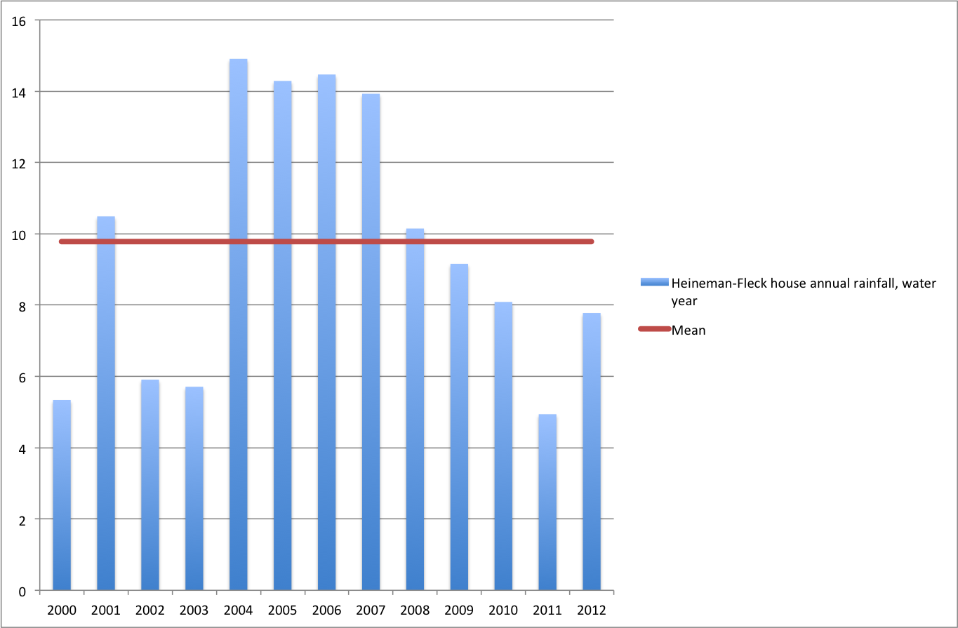
Water year rainfall at the Heineman-Fleck house
* Water managers here usually (though not for all purposes) measure their “water year” from Oct. 1 to Sept. 30 in order to capture a single full winter rain/snow season and the following spring summer water usage season in one annual number.
beneficial use: quaint, yet enduringly sturdy
From this week’s Albuquerque Journal, a piece looking at the history and future of the notion of “beneficial use” in western water law:
The doctrine’s history is bound up in the ideas of the generation of European immigrants who swept across the region in the 1800s, establishing what became United States law.
“The climate is dry,” a Colorado judge wrote in 1882, explaining the concept, “and the soil, when moistened only by the usual rainfall, is arid and unproductive; except in a few favored sections, artificial irrigation for agriculture is an absolute necessity. Water in the various streams thus acquires a value unknown in moister climates.”
The quote is from the Colorado Supreme Court’s decision in the case of Coffin et al v. The Left Hand Ditch Company.