My education in economics: Public Goods

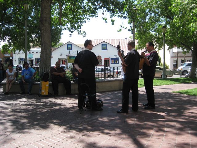
Once this resource was provided*, those who failed to pay for it (such as me, drifting through Albuquerque’s Old Town plaza at the end of a long Saturday bike ride) could not be excluded from enjoying its benefits. In addition, my consumption of the resource (sitting in the shade listening to the music) did not, for all practical purposes**, diminish the ability of others to enjoy it on an uncrowded Saturday afternoon:

Public goods, Albuquerque style

Public goods, Albuquerque style

* As I understand it (and don’t consider this “publication quality” information, it’s very second hand), a city of Albuquerque grant funds the musicians’ presence.

** These guys are awesome, so one can imagine that the plaza could grow increasingly crowded in future as my global blog readership is increasingly drawn to Albuquerque on Saturday afternoons, raising questions about the long term nonexcludability of this good. There were only so many seats in the shade.

Public goods definition adapted from Environmental & Natural Resource Economics (8th Edition)

Drought by the numbers

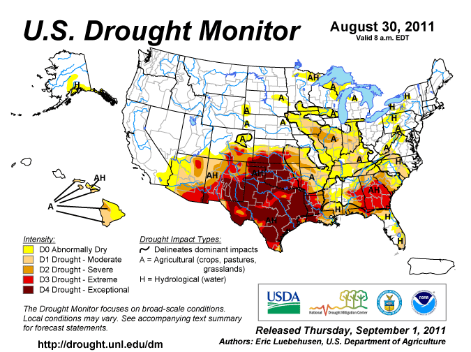
For the current water year, Oct. 1, 2010, through the end of August, I’ve had 4.39 inches (11.15 cm) of rain at my house in Albuquerque’s near northeast heights. That’s 51 percent of the mean going back to the 1999-2000 water year. Just one of the months, December, was above my long term mean, and nearly all that came in a single storm. I remember it because the roof leaked – 1.41 inch in a single night. Another way of putting it is that nearly a third of the rain this year came in a single unpleasant burst.

Drought Monitor, Aug. 30 2011

Drought Monitor, Aug. 30 2011

We just can’t win.

It’s not actually the driest first 11 months of a water year in my little personal instrumental record. In 2001-02, we had just 4.33 inches (11 cm even) over the same October-August stretch. That was year one of the epic two-year drought that killed so much of the piñon-juniper woodlands of the Four Corners. Dave Breshears did a nice job with that story:

At an intensively studied site within the region, we quantified that after 15 months of depleted soil water content, >90% of the dominant, overstory tree species (Pinus edulis, a piñon) died.

Driving across the high country here, you can still see the dead trees from back then. (A lot of them haven’t burned in the years since.)

I don’t keep a temperature record for my yard, but the big guys’ thermometers suggest it’s been a hot year here in New Mexico’s Middle Rio Grande Valley, which is the sort of thing Dave was looking at back in 2005 when he was trying to assess the effects of the remarkable 2001-03 event. It wasn’t just dry. It was warm:

This recent drought episode in southwestern North America may be a harbinger of future global-change-type drought throughout much of North America and elsewhere, in which increased temperature in concert with multidecadal drought patterns associated with oceanic sea surface oscillations can drive extensive and rapid changes in vegetation and associated land surface properties.

Worth noting: the forecasters are starting to talk seriously about another La Niña winter.

The Law of the River as a model for dealing with the loss of stationarity

Climate change and the resulting changes in rivers flows pose significant problems for transboundary water management agreements. But a new paper by Heather Cooley and Peter Gleick at the Pacific Institute finds a hopeful model in recent tweaks adding flexibility in the face of drought to the “Law of the River” governing distribution of water from the Colorado River:

In 2007, the USA implemented the Colorado River Interim Guidelines for Lower Basin Shortages and Coordinated Operations of Lake Powell and Lake Mead (referred to as the “Interim Guidelines”). This agreement, developed in the eighth year of the worst drought in over 100 years of record keeping, establishes specific guidelines for reduced water deliveries among the seven Colorado Basin states under drought and low-reservoir conditions. These shortage guidelines, which were developed in consultation with the Mexican government, are triggered at specific reservoir water levels in major reservoirs on the Colorado River (Lake Mead and Lake Powell), thereby providing water users with some indication of the frequency and magnitude of these events. The Interim Guidelines also create a novel multi-year water augmentation and banking programme known as “Intentionally Created Surplus”, allowing lower basin water users to invest in extraordinary conservation efforts and store the water saved or generated by such efforts for delivery in future years. A related programme, called “Developed Shortage Supply”, creates similar mechanisms to generate and store water to be delivered during declared shortages, buffering the users against major reductions. These guidelines were drawn up among the USA Colorado Basin states and do not address deliveries to Mexico. Adoption of the Interim Guidelines, however, has provided impetus to Mexico and the USA to begin negotiations to determine the conditions that would prompt Mexico to accept reduced deliveries of Colorado River water, as well as potential mechanisms for adapting to such changes.

The paper is here (pdf) and Felicity Barringer has a nice writeup of some of the broader questions addressed.

Best training run ever?

My friend Jaime Dispenza, a triathlon coach, was out for a training run recently, when… I’ll let him describe it:

After my second of four intervals I approached the river and there standing in ankle deep water was a couple holding hands. OK, no biggie I have seen this before. Then I noticed there was a woman in a dress, holding a book and then it clicked, they were getting married. It truly was a beautiful setting with the cottonwood trees providing the shade and the rustling leaves a light background of noise.

I turned my iPod back on and continued to run hoping not to break their magical moment in the river. As soon as they saw me, they called me over because they needed another witness for the marriage and also another signature on the wedding license. Before I knew it they had me take off my shoes, socks and get into the water with them for the rest of the ceremony.

Best training run ever?

My water policy nightmare

I had a really scary dream this morning. My memory is vague, but I was somehow involved in making decisions about how to allocate the water in a big river among various users. But we didn’t have good data on how much water the river actually held.

Terrifying.

Some call it “maize”

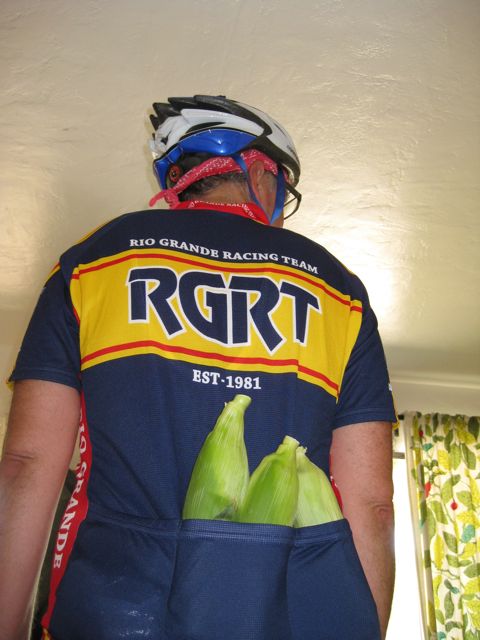
On my way home from a bike ride this afternoon, I stopped by the vendor selling sweet Moriarty corn out of her pickup truck on old Route 66 just west of Tijeras Canyon:

Maize

Maize, Augl. 28, 2011

I could only fit three in my shirt pockets, which will not be enough to get my family through the winter.

On Colorado River failure modes

One of my new tricks when looking at western water problems is to pose the question: “What is the failure mode?”

It’s clear that on many scales, both temporal and geographic, we’ve got supply-demand imbalances. It’s easy to point that out and call the system unsustainable, to point out that we’re headed for a crash. But I’ve become serially curious about how the crashes will manifest themselves. If we stay on the present trajectory, who/what is the person/institution who will lose their water first?

In a piece over at the Lane Center earlier this month, I argued that the answer for the current drought on the Colorado River so far has been “no one”:

Such is water management on the Colorado River that, in the wake of the worst drought in a century of record-keeping, from 2000 to 2010, everyone in the seven western U.S. states and Mexico that depends on the Colorado River continued to get their full allotment.

I got a thoughtful email in response from Jennifer Pitt at the Environmental Defense Fund who pointed out why that’s not quite right (quoted with permission):

The real casualty of the decade of drought is the Colorado’s delta. While the LB states ate their way through storage, the delta remained dry, save for a couple of times that the Gila ran and a few small flows released when there were infrastructure problems elsewhere (eg after the earthquake). Significantly, the absence of any kind of substantial regular flows in the delta means the alluvial aquifer is drying out where it’s not recharged by irrigation. We’re losing habitat on the river.

Jennifer’s making a great point here that highlights the fact that the “failure mode”, as I’ve been defining it, most often starts with humans continuing to take a full allotment of water from the system in question, while the environment gets shorted. Here in the United States, that explains why so many water supply battles are fought as Endangered Species Act battles – because water for endangered species is the first place the trouble shows itself.

In this case, the Colorado Delta is in Mexico, so ESA doesn’t apply.

Stuff I wrote elsewhere: on the power of moving water

The results of a couple of trips north last week into the flood zone in the canyons below the watersheds burned by the Las Conchas fire (sub/ad req):

In Cochiti Canyon, a New Mexico Environment Department team estimated the Aug. 21 flow that caused the first round of damage at Dixon’s at 12,000 cubic feet per second of water — more than 10 times the entire current flow of the Rio Grande.

After that flood, Ralph Ford-Schmid and his Environment Department colleagues installed a new temporary flow meter in Cochiti Canyon upstream from the orchard. They put it six feet up in a tree on an embankment that was another 10 feet above the canyon bottom. “We thought it was safe that high off the ground,” said Ford-Schmid.

It was not. It was battered by Monday’s flood pulse, and Ford-Schmid said a calculation of the height of the water the second day suggested 16,000 to 19,000 cubic feet per second.

Here’s why:

On a normal forested landscape, Meyer said, only 2 percent of the water that falls as rain flows off and downstream. Following a major fire, as much as 75 percent of the water can run off the landscape.

Once the water gains momentum, it can begin cutting little rivulets into the hillsides, “almost like the whole thing’s cat-scratched,” Meyer said.

As the running water picks up fine soil particles, it becomes more dense, which allows it to carve deeper and carry ever larger rocks and boulders, feeding on itself, creating a thick heavy slurry of flowing debris and gaining momentum as it goes. Jones’ photos of the second-day Cochiti flood show a wall of thick gray slurry plowing through the Dixon apple groves.

Water names in the West

Stewarts, Goodwater AZ

Stewarts, Goodwater AZ

If you’ve driven the stretch of Interstate 40 across northern Arizona between Gallup and Holbrook, you’ve perhaps seen the signs for a place called Goodwater. If you’ve not, trust me – there’s not much good water around those parts. The story of human settlement in the region is the story of the struggle for good water, precisely because there is so little of it. Holbrook, the nearest town to Goodwater I could find with a long term weather record, averages 8 inches (20 cm) of precipitation a year.

Goodwater, I once wrote, “has always looked to me like one of the driest places on earth.”

Which is why Richard White’s description of Rock Springs, Wyoming, in Railroaded struck me:

Despite the town’s name, its water came in by tank cars.

Rock Springs gets about the same annual precip as Goodwater, near as I can tell.

Any other favorite watery names in the arid West?