Top Inkstain Posts of 2010

Returning to a fine New Year’s tradition*, I bring you the most-read Inkstain posts of 2010.

The thing is, it’s frankly a crap list, or at least a particularly odd one. It’s not based on some profundity on my part, but rather some weird Googlejuice, drawing random readers who no doubt click, scratch head, then leave, because it wasn’t what they were looking for:

  1. Dust in the Sahel
  2. Malaria and Global Warming (depending on how I do the counting, these first two positions reverse – call it a tie?)
  3. The Sheet Metal Screw Fairy (I’m reasonably certain people leave this post disappointed. It has a certain charm, but is at a bit of a remove from the search terms.)

It’s only when you get to position #4 that you get a real post I wrote this year where I think I actually had something useful to say – Drought, American Style, on my visit to Hoover Dam last October on the day Lake Mead dropped to record low elevation:

We are sufficiently buffered by affluence that almost no one I talked to today had any inkling of what was going on. Just another tourist Sunday on Hoover Dam. The best I got was from one the folks in this picture, who were on a Sunday drive at one of the Lake Mead overlooks. One of them, a Las Vegas resident, knew the lake was way low, and said the solution was simple – somebody needs to have the political courage to make them release more water from Lake Powell, upstream.

For search terms that bring readers to Inkstain, “Sahel” is number one, and I’m happy to see “Lake Mead drought” on the list. But my particular favorite slots in at #31: “the Indian of the group“.

Happy New Year.

* OK, it’s really what I saw some dude do just now on Twitter. Working a holiday shift at the office. Bored.

Stuff I Wrote Elsewhere: The New START Bargain

From the newspaper this week, a look at the bargain that was struck to win support for the New START nuke deal with the Russians (sub/ad req), which includes money for a new plutonium lab at Los Alamos to replace its aging CMR building – despite dramatic cost increases and schedule delays since the project was first proposed:

In the short term, the deal ensures money to keep patching up the old CMR building, now 58 years old and well past its “best used by” date. Nuclear weapons scientists analyze plutonium samples in a building long ago labeled unsafe by federal nuclear auditors.

In the long term, there will be money — quite a lot, it appears — to build a replacement.

At this point, in the topsy-turvy politics of Washington, where a deal became the most important thing and damn the details, money appears to have been no object.

Moving Water, Virgin River Edition

I’ve been watching Lake Mead rise remarkably as a result of last week’s storm that blew through Nevada before drenching the Virgin River watershed on the Arizona-Nevada-Utah border area. It looks like Mead will finish December at a surface elevation of about 1086.25 feet above sea level, 2 feet above the level forecast a month ago. That translates to about 170,000 extra acre feet of water.

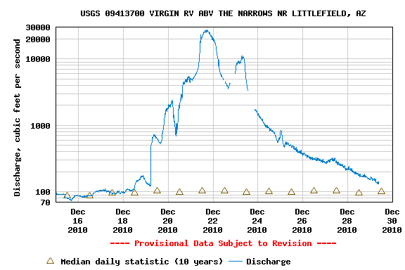
The flow on the Virgin was remarkable. At the gauge near Littlefield, Arizona, flow at this time of year is typically about 100 cubic feet per second. On Dec. 20, it peaked at at something like 27,000 cfs (they think – tough to measure accurately in conditions like that):

USGS Stream Flow Measurement on Virgin River near Littlefield, AZ, Dec. 2010

USGS Stream Flow Measurement on Virgin River near Littlefield, AZ, Dec. 2010

Or, seen another way:

Growth and Water

I’m certain this graph is of enormous importance in understanding long range water issues in the west. But I’m not entirely sure how.

It’s single family home starts in the  Phoenix (blue) and Las Vegas (red) metro areas over the last decade:

Phoenix, Las Vegas home starts

Phoenix, Las Vegas home starts, courtesy St. Louis Fed

What you see here is the housing bubble bursting. Adam Nagourney did a nice job in the New York Times last week of explaining what this means in Nevada, where demographers say population is actually declining – a remarkable fact for what on paper looked in the 2010 census like the fastest growing state in the country:

The state demographer, Jeff Hardcastle, estimated that Nevada had lost more than 90,000 people since July 2008, and expects the decline to continue through next year. He said that before 2007, Nevada had been the top-growing state for most of the past 20 years.

The Economist jumped in with stark employment figures:

Depopulation in Nevada would be particularly unpleasant given the housing overhang in the state that has already driven home prices in Las Vegas down by nealry 60%. Further population exits would increase supply relative to demand, generate more price drops and potentially more defaults. Of course, falling prices could ultimately lead to a new influx of residents attracted by cheap housing. But the adjustment process will be difficult, and the new Nevada economic model will look very different from the old one.

Phoenix also has seen a drop in its civilian work force, though not nearly as great in percentage terms as Las Vegas. But this all leaves me wondering about water. In the short term, it buys breathing room. But in the long term, what will the economic model look like, and what does that imply for future water demand?

River Beat: Conservation before shortage?

Shaun McKinnon reports this morning on a very interesting proposal under discussion in Arizona:

Under a plan now being considered, water officials would pass up billions of gallons that they could take from the river in 2011, hoping to keep the drought-stricken reservoir full enough to avoid triggering automatic cutbacks. Any cutbacks could deny Arizona and Nevada even more water in 2012.

The sacrifice would be relatively small – 80,000 acre-feet out of Arizona’s annual share of 2.8 million acre-feet – and it would barely be missed. Officials would take all of it from a portion of the water set aside for underground water storage, leaving consumers, cities and farmers unaffected.

Still, the attempt to prop up Lake Mead’s supply underscores how times have changed for a state that worked so hard for so many years to take every drop of river water it could.

You don’t have to be dry to be water short

Georgia averages 50 inches (127 cm) of rain a year. Arizona averages 13 (30 cm). Which is more likely to suffer water shortages? I’m fascinated by the non-trivial nature of the answer.

The problems of both lakes Lanier and Mead have been well chronicled. At Lanier in 2007, we were within three months of Atlanta running out of water. On Lake Mead, we’re – well, we’re all running around like our hair’s on fire, but we’ve got more than a three month supply sitting in our ginormous reservoirs. You can run the numbers and see some dire scenarios on the dry site of the range of probability, but our hair is substantially less flammable than Atlanta’s.

Lake Lanier

Lake Lanier

To refresh the important details, Atlanta’s hair-on-fire moment came after what was very much a garden-variety drought, nothing at all out of the normal envelope of climate variability. We’ve made it through a drought far more significant here in the Colorado River Basin in terms of depth and duration, much farther out of the normal range of variability (11 driest years on record, etc.), and yet all the Colorado’s users have gotten their full allocation every year during the drought.

There are two reasons for this. One is a system that was engineered with very large storage as a buffer against multi-year droughts. The second is an interlocking network of institutional arrangements for the distribution of that water that have been used to sort out arguments over how to administer things as the big reservoirs dropped.

The southeastern United States lacks both. Which is a very circuitous introduction to an interesting news release out of the University of South Carolina this week:

Water scarcity in the western United States has long been an issue of concern. Now, researchers studying freshwater sustainability in the U.S. have found the Southeast, with the exception of Florida, does not have enough water capacity to meet its future needs either.

“For more than a century, the Southwest has been the focus of long-running legal disputes over water resources, but the Southeast is now becoming a more contentious region for water use,” said Dr. Will Graf, a geographer in the University of South Carolina’s College of Arts and Sciences.

Graf was part of the team that did the recent “Cadillac Desert” empirical reconstruction in PNAS. While the southwest, Divas of the Arid, got all the attention, Graf and colleagues point out implications for the southeast as well:

“It turns out that the Southeast has a relatively small margin of water surplus for the future,” said Graf.

And we’ve got the institutional and engineering framework in place to try to work out our problems. The southeast is still down near the bottom of that learning curve.

US-Mexico Colorado River Deal

U.S. Interior Secretary Ken Salazar and Mexican Environment and Natural Resources Secretary Juan Rafael Elvira Quesada signed an agreement today that, for the first time, allows long-term storage of Mexican Colorado River water in U.S. reservoirs.

It’s an attempt to solve a short-term problem – the inability of Mexican users to take their full allotments because of damage to water distribution infrastructure caused by an April earthquake. Rather than lose the water (Mexico has no large storage facilities), the agreement allows 260,000 acre feet of water to be stored in Lake Mead between now and the end of 2013. When the canals are fixed, the Mexicans can then call for their water.
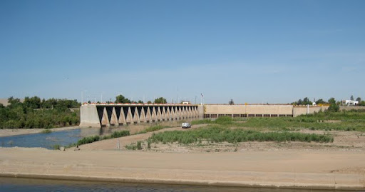
Morelos Dam

Morelos Dam, US-Mexico Border, April 2010

This is a win for folks in the United States, because the water would keep Lake Mead’s levels higher than they otherwise would be, reducing the risk of a shortage declaration should Mead’s levels drop below 1075 feet above sea level. (260,000 acre feet translates to something in the neighborhood of 3 feet.)

So both sides benefit. But the real importance of the agreement is less in the details, and more in the precedent it sets: it is the first trans-boundary water management agreement that allows Mexican water to be stored in the United States. As such, it will provide a learning experience for possible future arrangements that could be more far-reaching.

In their July 2005 “conservation before shortage” proposal, a group of NGO’s that included the Environmental Defense Fund proposed such trans-boundary agreements to create more flexibility for solving the Colorado’s water management problems.

One of the difficulties in crafting solutions to the Colorado’s growing sustainability problems is the limitation imposed by governmental boundaries – state and tribal lines, as well as the upper and lower basins within the United States, and the U.S.-Mexico border. Legal and political structures make it extraordinarily difficult to manage water across those boundaries – to conserve water in one jurisdiction, for example, that it might be used in another.

Within the lower basin, an approach called “intentionally created surplus” is one attempt to overcome some of these problems. For example, the Drop 2 Reservoir along the All-American Canal will save water in California. It is being funded in part by the Southern Nevada Water Authority in return for the ICS credits, which has the effect of conserving water in California for use in Nevada.

In their announcement today, Salazar and Elvira Quesada said broader negotiations will begin next month on “a comprehensive agreement on Colorado River water management issues, particularly in light of ongoing drought conditions and the prospect of continuing declines in reservoir levels.”

The Environmental Defense Fund’s Jennifer Pitt, one of the key authors of the 2005 proposal that suggested such trans-boundary collaborations, issued this statement today:

Given dire predictions of drought in this region, today’s agreement is a critical step in building the mutual trust and confidence we need to craft additional agreements that deliver a more sustainable water supply for our communities and for the environment.

Some notes on arcane details of the agreement:

  • Technically, the agreement doesn’t specify the reservoir, and it could be stored anywhere, but for all practical purposes, we can assume it’ll be in Mead.
  • Mexico will pay a 3 percent evaporation cost per year on the water stored.

River Beat: Storm Coming

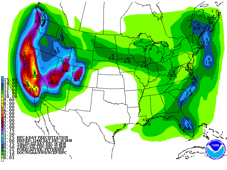
12/18/2010 QPF for western storm

Quantitative Precipitation Forecast Dec. 18-23

If you’re a western water manager, the corners of your smile must be crinkled up in delight at the latest Quantitative Precipitation Forecast from the National Weather Service. That’s some mighty big bulls-eyes you see on the map over the Sierra Nevada and the Colorado River Basin.

Going into this, the snow pack in the basin above Lake Powell is at normal levels for this point in the year, according to the Colorado Basin River Forecast Center’s summary of Snotel sites (that link takes a bit of time to load).

The storm comes on the heels of the annual Colorado River Water Users Association meeting in Las Vegas (Nev.), where Interior Secretary Ken Salazar said this:

As I speak to you today, the Colorado River is facing a record drought. The period between 2000 to 2010 has been the driest 11-year period in the 102-year historical record for the Colorado River Basin. Moreover, scientists who examined tree-ring data estimate that this period is one of the driest in the Basin in over 1,000 years.

And there are no clear signs of an end to this drought. The countless communities that rely on the river to sustain them are being forced to make tough choices at a time with few obvious solutions in sight.

Moreover, as we enter our second decade of drought conditions, another reality complicates the picture: climate change and its emerging challenges—challenges that we are only just beginning to understand– may dwarf in complexity the issues that the Basin States have faced so far. Some estimates have identified a risk of a 20-30 percent decline in available water supplies in this Basin due to climate change.

We’re in a La Niña year, and the Christmas Week Storm of ’10 is a reminder that the conventional wisdom about a year like this – dry in the southwest – can be a bit misleading. That really means southwest, and  the farther north you go, the less of an effect La Niña has.

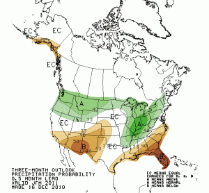
Jan - March 2011 Forecast

Jan - March 2011 Precipitation Forecast, courtesy CPC

It has been dry so far south of the Utah/Arizona and Colorado/New Mexico borders. Despite a nice storm yesterday across New Mexico, for example, most of the Snotel sites down here are still below average. Even with this latest storm, the San Juan river above Navajo Dam in northwest New Mexico is at just 58 percent of average. Above the Oso Diversion in southern Colorado, which shunts water off to the Azotea Tunnel and the San Juan-Chama Project (Albuquerque’s drinking water supply), snow pack is at 74 percent of normal.

But the great truth that John Wesley Powell first noticed – snow in the high Rockies feeding the great deserts of the southwest – may bail us out this year, if enough of the Colorado River Basin is above the La Niña line.