Water in the Desert: Benefits Left Untapped

Doug MacEachern has a fascinataing discussion in today’s Arizona Republic about the canals of Phoenix. I remember being struck the first time I visited Phoenix by these strange concrete waterways. I’d driven up to the north end of town to make a pilgrimage to the (sorta) Frank Lloyd Wright Biltmore, an oasis of a thing built for the rich. It’s green and luxuriant, and then right in front is this big concrete river carrying water past, and the Biltmore’s architecture completely ignores it, like its only relevance was as an obstacle to the entrance road.

A few years back, when Lissa and I visited Phoenix, we spent some time ambling around trying to look at the canals. It was hard. They’re not rivers. They’re plumbing. This picture is the best I could find from our trip, a little diversion structure taking water out of one of the big canals down the hill to a neighborhood of citrus groves:
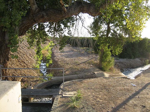
The actual concrete canal is up to the left, completely ignored by the neighborhoods that surround it – in fact largely inaccessible.

MacEachern writes about a discussion going on now in Phoenix about the possibility of reintegrating the canals into the cityscape, the way they apparently used to be:

Especially during the rapid expansion of the urban Valley after World War II, SRP’s dedication to efficient, effective water delivery rapidly began altering a once-cozy relationship of the Valley’s communities to their canals.

Where a formerly agrarian Valley was once resplendent with tree-lined, earthen canals, the post-war canals were remodeled quickly into . . . something else. The thousands of enormous cottonwoods that once proliferated along the earthen canal banks began disappearing. And the canals themselves, which once provided easy access for swimmers and picnickers, were covered over in steep, foreboding concrete.

It echoes a similar discussion going on now in Albuquerque, regarding the extent to which the network of irrigation ditches criss-crossing the valley floor should be treated more broadly as a network of recreational trails. From Gwyneth Doland:

For years, residents in Albuquerque’s North Valley have been pushing for a formalized system of recreation trails along the irrigation ditches, or acequias, an idea the current board has unanimously rejected. Supporters of the trail plan are hoping that electing new board members will pave the way to change.

The discussion here is a little different. The ditch banks in Albuquerque’s valley are already embraced as informal recreational trails by many, and the argument here is not so much about whether that is a good thing, but about the ways in which it might be formalized.

But in both the Phoenix and Albuquerque cases, it highlights a classic market failure – a positive externality (recreational benefits for all!) that is not internalized in our formal decision-making about the management of our water system.
Who Believes What?

My Albuquerque Journal colleague Mike Coleman has a post this morning that illustrates the complexity of the science-politics-policy interface surrounding the cap-and-trade legislation now slogging through Congress. It’s about Harry Teague, a newly elected conservative Democrat from New Mexico who represents a very conservative district with a strong oil and gas component to its economy. (A portion of the district overlies the Permian basin, and southeast New Mexico is very “Texas oil patch” in many ways, not at all the sort of Georgia O’Keeffe country that the name “New Mexico” evokes to outsiders.)

The bill’s handlers gave Teague some major concessions involving small oil refineries to win his vote (see Mike’s story for details on the deal). But Teague has apparently been getting beaten up anyway by some of his constituents over the issue, which leads us to this:

Does Rep. Harry Teague think climate change is real?

Yes, he does, Teague’s spokeswoman told me this morning. But the congressman believes the jury is still out on the reasons why it’s happening.

Stuff I Wrote Elsewhere: Solar Water Edition

Does solar energy have a water problem? That’s the question I tried to address in this story (sub. req. sorta) over at the day job:

Look at any map of U.S. solar energy resources, and you will see a band stretching from southern New Mexico across Arizona and into California that shows promise.

Solar energy advocates see a strip of clean, green power growing up in the region.

But if you think closely about what the map is saying, as Arizona water expert Chris Brooks points out, you will see something else. The potential for a solar bonanza is happening in the driest part of the nation. And solar energy, in its most cost-effective form, uses water.

“You need to put it someplace where the sun shines, and a lot of those places tend to be dry.” said Brooks, a Tucson hydrologist and lawyer who writes the Watering the Desert blog.

But it turns out not to be as interesting a problem as I think it has been made out to be, for a couple of reasons:

Experts note there is nothing special about this particular version of the energy-water debate. Many other sources of electricity, especially coal and nuclear power, use large quantities of water for power plant cooling, just as the new solar plants do.

In New Mexico, in fact, the biggest water hog on the new energy horizon is a big new coal plant proposed for northwestern New Mexico. Meanwhile, solar advocates point to alternative types of sun-fueled power plants they say can produce electricity while cutting back on the amount of water consumed.

In other words, there’s nothing terribly special about solar energy. It’s just teh one we’re currently talking the most about. And the tradeoffs are relatively straightforward. You can use less water, it just reduces your plant’s efficiency, essentially making it more expensive per kilowatt hour of power.

Groundwater Pumping Undermining Surface Canal?

The irony here is just too rich:

Fearing the main canal carrying drinking water to millions of Southern Californians is sinking again, water officials are monitoring the effects of incessant agricultural pumping from the aquifer that runs under the aqueduct.

Their concern is that the canal, which has sunk six feet in places during California dry spells, will buckle enough to slow delivery of water to parched points south and force costly repairs.

Notes from the Road: Utah State Route 95


Utah State Route 95

Originally uploaded by heinemanfleck.

I know that as a 21st century westerner of a certain sort, I’m meant by religious tradition to abhor Utah State Route 95. But dang if it isn’t about the most beautiful highway I’ve ever had the pleasure to drive.

Go south a bit, then west out of Blanding, Utah, and SR 95 takes you over comb ridge and into the canyon country, with none of the rattling dirt roads and axle-mangling ruts a genuine westerner would find essential to his or her true enjoyment of the breathtaking beauty of the canyonlands of southeastern Utah.

This is the place where Hayduke and his friends took one of their most dramatic stands, where monkeywrenching got its name in a saga that somehow has seeped into our consciousness as history when it’s really not. The gang parks up on Comb Ridge, a beautiful ridge of upturned sedimentary rocks unusual in the normal flat-lying landscape of the Colorado Plateau. The Atomic Energy Commission brought the first wave of 20th century invasion across Comb Ridge, cutting an old dirt road for the uranium miners. It was the second wave – paving the road – that Hayduke and company were trying to stop.

They poured Karo syrup in the gas tanks and sand into the crankcases of the big machines being used to build the road. It is The Monkey Wrence Gang that provides the religious tradition to which I refer, a sort of sacred text perhaps for a 21st century westerner of a certain sort?

And it is the fruits of that second wave that Lissa and I drove on our recent vacation, down past Fry Canyon to Hite, the little Utah river crossing where the Dirty Devil meets the Colorado. Hite once had a ferry, but that was inundated when Lake Powell filled, and a bridge a couple of miles upstream now carries our autos effortlessly across what was once a most difficult route – the only practical place for probably a hundred miles in either direction (Moab upstream, Lee’s Ferry downstream) where you can cross the Colorado.

To the north, the road breaks out of the red rock canyon country, losing the reds, to the barren tawny browns of Hanksville and places like it. There every place where the water is close enough to reach was settled by hardy Mormon pioneers, people able to make a life here that no other European immigrants could stomach for reasons and in ways I’m still trying to understand.
map

Free Water!

Who knew California had a source of free water, right under its very nose!

The cheapest source of water is fresh groundwater, which costs only 4 cents per gallon, but it is not always present in local aquifers.

Groundwater tastes just like imported water, uses less electricity to distribute because it is pumped closer to home, and is always in the ground, drought-proof, Garrod said.

But is it really such a good idea?

The growing interest in groundwater concerns the San Diego County Farm Bureau and the San Diego chapter of the Sierra Club. Both are worried that overdrafting – the process of extracting groundwater beyond the aquifer’s ability to sustain itself – could affect farmers and wildlife.

But county water authority and Sweetwater Authority officials said no municipality would be foolish enough to deplete its aquifers. (emphasis added)

My experience suggests that, to the contrary, an awful lot of municipalities, agricultural users, and pretty much anyone else with enough money to drill a hole and buy a pump has, in the past, been foolish enough to deplete its aquifers.

Ribbon of Green


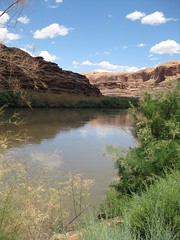
Colorado River at Moab

Originally uploaded by heinemanfleck.

There’s a moment when you’re driving across the deserts of the southwest as the road tops a rise and you get your first view of the ribbon of green along a river.

That’s where the towns are, and that’s where the cool is, a break in both temperature and color – from hot to a bit cooler, from the reds, browns and yellows of desert rock and earth to the riparian greens of cottonwoods and, now, salt cedar, dipping their roots in the groundwater that leaves as much or more river underground as you see above. The striking thing is always how sharp the boundary is between dry and wet. Add a town, and you often have irrigation, a few fields tacked along the bottonlands on either side of the river. And, often, a place to buy ice cream. I learned this as a kid, on epic ’60s family car trips through The West, before the days of air conditioning, and I’ve loved the moment ever since.

Lissa and I shared the experience numerous times over the last week on a road trip up through Four Corners country – in Bloomfield on the San Juan, at Hite where the Colorado meets the Dirty Devil in the canyon country of southern Utah, as the interstate meets the Green. And one of my favorites, the site where this picture was taken, on the Colorado River just upstream from where the highway drops down from the north, past the entrance to Arches National Park.

I had occasion on this trip to pick up a copy of John Van Dyke’s “The Desert”, an essay written a century ago about Van Dyke’s strange and wonderful wanderings of the lower Colorado. He saw it too:

The desert terraces on either side (sometimes there is a row of sand-dunes) come down to meet these “bottom” lands, and the line where the one leaves off and the other begins is drawn as with the sharp edge of a knife. Seen from the distant mountain tops the river moves between two long ribbons of green, and the borders and the gray and gold mesas of the desert.

Liveblogging Nature’s Half Acre

9:01 am:

Watching roadrunner in the backyard. Unsuspecting sparrow flies up. Snap. Sparrow dead, spectacle of roadrunner breakfast kinda gross.

9:05 am:

Two house finches and a white-winged dove sit on power line, watching roadrunner eat sparrow. Are they, in fact, “watching”? Do they care?

9:09 am:

Roadrunner sitting on a stump, wiping off his beak. Can’t see what he did with breakfast.

9:22 am:

Roadrunner has left, pile of feathers on the ground where he dined, but can’t see a carcass anywhere.

Energy-Water Follies, Jatropha Edition

I’ve got this energy-water hammer, and they all look like nails right now. Today’s nail is jatropha, one of the next-gen bio-energy darlings. Or not:

Jatropha, a biofuel crop favoured for its ability to grow in areas not suitable for food, may be about to become less popular.

A new Dutch study shows it uses 20,000 litres of water to produces one litre of jatropha biodiesel – more than the other crops used for biodiesel, rapeseed and soybean; and a lot more than ethanol crops such as maize (corn).

Drought Causes Crime?

This one was enough to lure me away from the all-MJ/Farrah news feed this morning:

In some valley towns the crime rates have soared. The link, officials suggest, are the water shortages to farming communities. The drought is said to have lead to higher crime rates in some Valley towns.

In the farming community of Mendota crime is up 100 percent, officials reported. Fresno County District Attorney Elizabeth Egan said that the spike is tied to the water crisis.