The challenge of meeting a legal and moral obligation to Colorado River Basin tribes

At last week’s Getches-Wilkinson Center conference in Boulder, attorney Jay Weiner, who represents tribes (but was careful to say he was not speaking on any particular tribe’s behalf) made an important point, which is repeated in this excellent piece by Mark Armao this week in Grist:

“The basin is free-riding off of undeveloped tribal water rights,” said Jay Weiner, an attorney for the Quechan Indian Tribe. Weiner said there is a “fundamental tension” between tribes’ desire to fully develop their water rights and the overarching need for everyone in the basin to consume less water overall.

Kathryn Sorensen on getting real in the Colorado River Basin

High Horses

At last week’s Getches-Wilkinson Center conference on Colorado River stuff, I had the privilege of moderating a panel with the provocative title “Time to Get Real”.

The opening remarks from Kathryn Sorensen of Arizona State University seemed worth repeating, and she kindly gave me permission to post on the blog (the pictures were her slide deck, accompanying the remarks):

By Kathryn Sorensen

John Fleck asked each of us to consider the following:

What does getting real in the Colorado River Basin mean?

I’ve got three things:

First, with humility and respect, it means that we all need to get off our high horses.  Everyone.  Me, you, everyone in the basin.  Thinking that your water use is justified, and no one else’s is, is not helpful.  Thinking that you know how water should be allocated and everyone else has it wrong, is not helpful.  And it’s going to push us into camps at a time when we need to focus on collaboration.

Second, it means that it is not helpful to continue to talk about closing the gate. There is a long history of people moving out here to the West and then wanting to turn around and close the gate.  Unless you are a Native American and your family has been here since time immemorial, you do not have the moral high ground to close the gate.  There’s something like 8 billion people on the planet.  Our cities are going to continue to grow.

Our energy is better focused on making sure all families that live in this basin, whether they have lived here since time immemorial or moved here yesterday, have equitable access to safe clean drinking water and effective sewer service.

The Arizona Navy

Third, it means that the basin is aridifying, the Lower Basin is using too much water, and the system is draining.  We need to cut water use in the Lower Basin very significantly.  Like Senator Sinema, I’m not going to give you a number.  Everyone knows we Arizonans are a difficult bunch.  If you are not convinced of this, I am happy to convince you further.  But on a long-term, sustained basis, the Lower Basin needs to cut by more than 500,000 AF, and I don’t see how, politically, we can cut 3 million. That being said, if we get another year or two of terrible runoff, we may not have a choice.

But have some faith.  Save a little optimism.  solving for water scarcity is really hard, and the problems we face are enormous.  I don’t want to minimize those. But still, solving for water scarcity is technologically easier and less expensive than solving for flooding and seawater intrusion.  So we got that going for us.

Thank you.


Taking climate change seriously: the Colorado River “stress test”

Courtesy Dave Kanzer and Eric Kuhn, from Eric’s 2013 Colorado River Water Users Association presentation


The Bureau of Reclamation Colorado River team did something remarkable in yesterday’s release of its new 5-year reservoir levels analysis – the “stress test”, a methodology pioneered a decade ago by an Upper Colorado River Basin technical team that included John Carron of Hydros and Eric Kuhn and Dave Kanzer of the Colorado River District is now the “new normal”, to borrow a terrible phrase. From the “5-year projections approach tab” here:

The method used to generate future inflows in the current projections includes resampling a subset of the historical natural flow record (1988-2019) using the Index Sequential Method (ISM), referred to here as “Stress Test” hydrology. In the past, the full historical record (1906-2019), known as the “Full” hydrology, was used to provide 5-year probabilistic projections. The Stress Tests hydrology scenario applies ISM to a shortened period of the natural flow record, 1988-2019, which removes the earlier portion of the natural flow record and focuses on the recent (approximately 30 years) hydrology. This period has a 10% drier average flow than the Full hydrology. Use of the Stress Test scenario is supported by multiple research studies that identified a shifting temperature trend in the Colorado River Basin in the late 1980s that affected runoff efficiency and resulted in lower average flows for the same amount of precipitation (McCabe et al. 2017Udall and Overpeck 2017Woodhouse et al. 2016).

The idea is that the traditional approach – using the entire period of record to model the probabilities of future river flows – is not longer valid because climate change is changing the river.

John, Eric, and Dave reasoned nearly a decade ago that using a shorter record, focused on our climate-changed Colorado, might better help managers think about and plan for what to expect next. (Dave also famously provided the memorable Homer Simpson image for Eric’s CRWUA presentation).

The “stress test” has been creeping into basin management discourse for a while, and Reclamation had already begun publishing stress test scenarios alongside. But the new 5-year flow and reservoir level estimates now are all in on the stress test.

The stress test may not be stressful enough, which was one of the implicit messages in the editorial Brad Udall and I published in Science magazine in May, and which Brad and I made more explicit here. But this use of the stress test is nevertheless hugely important, kudos to the Reclamation technical and management team for this important step.

Dry in all my river basins

odds favor a dry autumn 2021 in the watersheds that matter to me

Getting ready for class class discussion this afternoon about “drought” (“I get to see my students in person!” he exclaimed nervously.), I had occasion to check the latest Climate Prediction Center long lead forecast. It’s a few weeks old, but I don’t expect it’ll have changed much.

The brownest blob captures both river basins I care most about – the Rio Grande and Colorado, with odds tilted toward drier than average conditions through November. (And it doesn’t get any better if you look at the longer leads.)

Today’s class teaching goal: there’s no one thing called “drought”, it has many different definitions depending on who and where you are. For me, the most important measure is soil moisture (now) and snowpack (over the coming winter). Those are the things that determine available water supply for the communities of interest to me. There’s some overlap between my “drought” and a forest’s, or a fish’s, but they’re not necessarily the same thing. (If any of my students are listening in here, that’s a clue to the “what did Prof. Fleck leave out of the recorded lectures” discussion question.)

After some time last week in the mountains of northern New Mexico and southern Colorado, where Albuquerque gets its water, I had occasion to pull the latest soil moisture modeling from the Colorado Basin River Forecast Center. CBRFC only does the Colorado River Basin side of the continental divide, but there’s no reason to think it’s any different on our side of that line.

I cringed:

Dry soil moisture heading into fall 2021 in the Colorado River Basin


On the importance of gathering stones

Round rocks of the San Juan-Chama project

I had the joy of sharing a goofy group text thread yesterday evening with a couple of friends exchanging pictures of the round rocks we each collected yesterday morning on a field trip to see the plumbing of the San Juan-Chama Project, which diverts Colorado River Basin water beneath the continental divide to bring drinking and irrigation water to New Mexico’s parched middle Rio Grande Valley.

The San Juan-Chama Project’s 25 miles of tunnels are the thread that connects us in central New Mexico’s Rio Grande Basin to water and its management across the Colorado River Basin. That makes the tunnels the thread that holds together the work I’ve been doing for the last decade trying to understand the relationship between the water in my little town of Albuquerque, New Mexico, and the water challenges of the greater West. But I’d weirdly never actually visited this vital bit of plumbing.

So when a friend invited me to tag along Thursday and Friday on a workshop and facility tour for San Juan-Chama Project water users to talk about infrastructure management and governance, I said “yes”.

We hung out Thursday afternoon at a lovely picnic shelter along the Rio Chama talking about concrete maintenance priorities and the crazy-sounding Law of the Colorado River governance rules. (The concrete discussion was fun, but I didn’t understand a lot of it. There were a lot of totally legitimate “What, what? Why did they do it that way?” questions about the crazy governance structures.)

Friday we toured the dams and diversions.

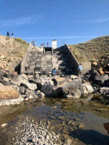
the mouth of the Azotea tunnel

When I told WT, one of my former students, that I was headed up to Chama for a facility tour, he told me I had to pick up some round rocks at the Azotea Tunnel. Azotea is where the water emerges from beneath the continental divide after miles of concrete tunnel. Rocks that make it through the intakes have been skittering and rolling for a good long while, like time in a multi-million dollar rock tumbler, before they emerge to be deposited as the water slows and begins its trip down Willow Creek and into the Rio Chama on its way to my Albuquerque faucet.

The group had swollen to about 30 by the time we got to Azotea, with about a dozen mostly white government rigs parked on the apron above the tunnel. And within moments of our arrival, the senior managers from central New Mexico’s largest municipal water agencies had scampered like kids down the rocky channel embankment to begin hunting for the best round rocks.

The headwaters snow is long gone, and the tunnel’s been dry save for a couple of late summer rainstorms since the second week in August, which sucks for water management purposes, but was great for round rock hunting!

The rocks were cool, but the real value was the earnest goofiness of the endeavor.

I write a lot about the importance of “social capital”, the personal bonds among the water management community’s problem solvers. That’s what this was about.

We sat out by the Rio Chama Thursday evening until well after dark, long after the grill had cooled, talking water until it was so dark you could see the Milky Way and the evening star (Venus?) next to a setting sliver of a moon. We artfully arranged the car-sharing arrangements so we had time to talk during the shuttling from one tunnel and diversion dam tour stop to the next. We clustered in the shade eating our salads and PB&J talking about the Green Book and water bypass rules and Sec. 11 of Public Law 87-483, the San Juan-Chama Project’s 1962 authorizing legislation.

We collected round rocks. And then gleefully texted pictures of them with one another after we got home.


Tradeoffs

This morning’s operations missive from the federal-state-local Middle Rio Grande operations group (by “Middle” here we mean central New Mexico) notes a release of ~100 cubic feet per second of imported San Juan-Chama Project water for environmental flows, an effort to help the struggling Rio Grande silvery minnow.

SJC water is removed from the Colorado River Basin in the San Juan mountains of southern Colorado, through a series of tunnels beneath the continental divide, for use in the Rio Grande Basin.

So – water from one troubled basin (the Colorado) to provide environmental benefits in another (the Rio Grande).

The driest on the Rio Grande since….

One measure of dryness on the Rio Grande

I’ve been thrashing about this year thinking about ways of visualizing and measuring how dry this year has been on my home river, the Rio Grande through Albuquerque. Above is my latest stab at it.

A flow of 100 cubic feet per second at the USGS gage at Albuquerque’s Route 66 bridge in the middle of town has always been a threshold I watch. That’s in part because for a time it was used as a criteria for Endangered Species Act compliance (no more), and in part because when it drops that low it just looks dry – a shallow braided channel meandering through muddy sand.

This particular bit of code counts the days each year below a specified threshold, and the graph above was created by setting that to 100 cfs.

The flows here are a combination of climate-driven inflows and human management. All those dry days back in the 1960s, ’70s, and ’80s were driven in significant part by river management – much larger diversions from the river for irrigation. The relative lack of dry days across much of the 21st century was also driven by river management – an ESA requirement to keep the river wet here.

In both cases that combines with hydrology.

Unfortunately we only have data for the Route 66 bridge gage since 1965. I’ve got some more work I’m doing (back later for that, gotta get to the day job) looking at other gages with longer records, but the interplay of gage history and diversion points makes that more complicated than I have time for this morning, still ingesting first coffee.

Yesterday was the 14th day this year with a daily average flow less than 100 cfs. Last year we had 14 such days. The last time we had more was 1989.

Flow this morning, as I write this, is < 80 cfs.

Brad Udall on Upper Colorado River Basin climate change risk

By Brad Udall, posted with permission, from his Aug. 18, 2021 presentation to the Colorado Water Conservation Board

Colorado State University’s Brad Udall has been doing some really interesting thinking about how to conceptualize and communicate climate change risk to water supplies in the Colorado River Basin.

Shown above (and shared with permission) is one of Brad’s “selected averages” graphs. The horizontal lines show the average river flow value for a period of interest – the entire period of record, for example, or the 21st century. (It’s from a presentation Brad gave to the Colorado Water Conservation Board earlier this month.)

While the general pattern will likely be familiar to people working on Colorado River issues – wetter in the long run, drier in recent decades – the value being graphed may not be. It’s “unregulated inflows”, which is the number calculated by the Bureau of Reclamation and the Colorado Basin River Forecast Center to estimate the actual inflows into Lake Powell, minus the impact of upstream reservoir operations.

It’s the best number to use if you want to look at the the actual water flowing into Lake Powell, and therefore available to meet compact-driven Upper Basin commitments to deliver water downstream to the Lower Basin at Lee Ferry. It combines both natural flows, and Upper Basin consumptive uses.

The key number to look at here is the one in the blue box. Since 2000, the average unregulated inflows have been 8.38 million acre feet per year. The Upper Basin’s Lee Ferry compact delivery “obligation” (lawyers please don’t subpoena me on this point, I ) is 8.23 maf, which means that we’re right on the edge of trouble even now, in terms of the Upper Basin’s ability to meet the expected deliveries to users in the Lower Basin. Increased Upper Basin use, or decreased flow (see Brad’s 6.66maf for 2018-2021) would cross that trouble threshold.

What this means is that, based on 21st century hydrology, the Upper Basin is already caught in what Doug Kenney and colleagues dubbed “the Upper Basin climate change squeeze”.

This is what Brad and I were getting at in our May editorial in Science. Lower flow scenarios are entirely credible based on the best available climate science and the hydrology we are seeing. We need analyses – modeling runs – that consider them as we prepare for the next round of river management negotiations, so that we know what will do if Brad’s scary “6.66” is a harbinger of our future.

How to Keep Cool

Life Magazine, July 19, 1923.

Other suggestions include keeping sleigh bells around to jingle when looking at thermometer. This was apparently before the widespread use of refrigerated air.

h/t Yesterday’s Print and my precious university library privileges.

Now out in paperback (and perhaps timely given the chaos?): Science Be Dammed – How Ignoring Inconvenient Science Drained the Colorado River

Our friends at the University of Arizona Press have kindly printed a bunch of new copies of our book Science Be Dammed, this time in paperback so it’s cheaper!

Eric and I did a fun Q&A with Abby Mogollon at the press to accompany this second launch:

Q: Why did you embark on this project?

A: We wanted to provide a resource that would contribute to better decision making. In the next few years, the Colorado River basin water managers and other stakeholders will be facing difficult decisions, including renegotiating the river’s fundamental operating rules – questions about who gets water, and how much. We recognized that the river has been legally overallocated for decades. We wanted to understand how this happened–how science was used/misused in the decision-making process and how that misuse of science has become embedded in the river’s governance structure. We believed that with the impacts of climate change adding a new level of deep uncertainty and complexity to an already overused river, it was important to understand how we got here.