Institutions, shaping landscapes

Driving between old Mesilla, New Mexico, and the Rio Grande this evening after dinner, Lissa and I saw a bunch of new pecan orchards going in.

We took last minute advantage of university spring break to head south. We spent some time wandering around looking at and thinking about the border, and also driving the roads of the Rio Grande valley floor as it spreads out south of Elephant Butte Reservoir on its way to El Paso and Juarez.

Both things are, in very different ways, examples of the way human institutions shape landscapes on a grand scale. With the new book done, we’re in the calm before the new book storm, and I’ve been thinking back to an idea I’ve had for some time about at thing to write. I’m not quite sure how to explain it, but involves the way what economists would call “exogenous forces” shape landscapes.

In the borderlands country, we’ve got the obvious case of a relatively arbitrary decision nearly two centuries ago to draw a line on a map in a particular place and a particular way that gives us this:

El Mesteño Cattle Co., Santa Teresa, New Mexico, USA

On the left is the El Mesteño Cattle Co. The thing in the middle is the U.S. Mexico border, I guess you’d call that a “fence”. Across the fence is El Mesteño’s counterpart in Mexico. It’s a transboundary cattle shipping point, in the middle of the desert.

Landscape, shaped by rules.

The border was more than a little uncomfortable, so Lissa and I dropped back down into the Rio Grande Valley and drove through miles and miles of pecan orchards, landscape shaped by a different set of exogenous forces.

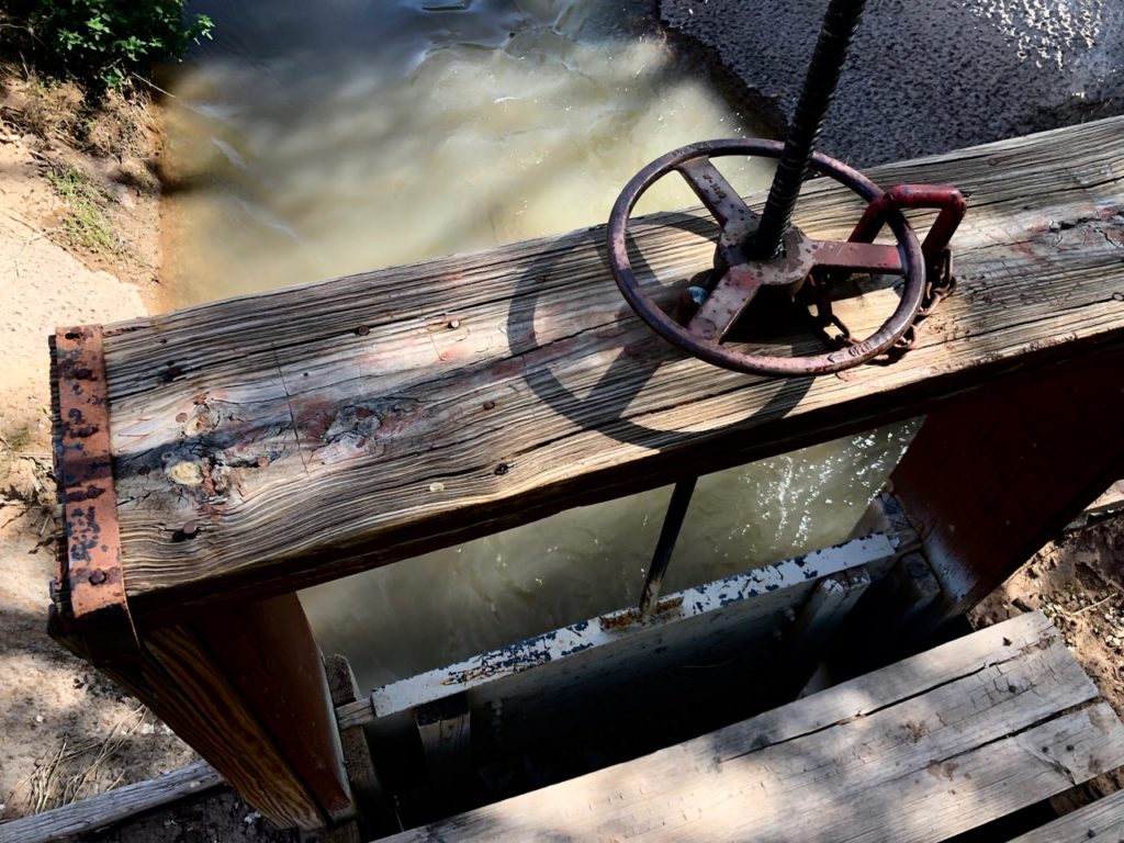
Down a side road through magnificent, lucrative groves, we came upon this:

Mesilla Dam

If you peer through the graffiti, you can see the “USRS 1915”. The U.S. Congress in 1902 passed the Newlands Act, which created the U.S. Reclamation Service (now the Bureau of Reclamation). In the teens, the Reclamation Service built the Rio Grande Project, which controlled flooding and distributed irrigation water to the Mesilla Valley. (The sand, you’re wondering. They turn the river off here over the winter, and haven’t turned it back on yet for spring irrigation season.)

The result today is forests of pecan trees, at this point more than 30,000 acres and growing. Among the exogenous forces shaping this forest is a set of rules that permits groundwater pumping when surface water flows are scarce, as they have been in recent years. Among the countervailing ecosystem pressures, if one could think of them that way, is a lawsuit by Texas, against New Mexico, arguing that the groundwater pumping violates the Rio Grande Compact’s water delivery rules.

countervailing ecosystem pressures here

A couple more threads here.

Pecan acreage here is up, from 24,000 in 2010 to 33,000 in 2018. Alfalfa, meanwhile, is down, from 30,000 acres in 2010 to 15,000 acres in 2018. As surface water grows scarce, groundwater pumping is expensive, pecans are lucrative, alfalfa is not. (This, at least, is my hypothesis. More study is needed.)

pecans

Exogenous forces, shaping landscapes. There’s a story here somewhere.

Southern California’s Metropolitan is prepared to go it alone to make a Colorado River Drought Contingency Plan Work

The Desert Sun’s Janet Wilson has an important update on progress toward a Colorado River water use reduction plan – the poorly named “Drought Contingency Plan”:

With a Monday deadline looming, the Metropolitan Water District of Southern California has offered to break an impasse on a seven-state Colorado River drought contingency package by contributing necessary water from its own reserves on behalf of the Imperial Irrigation District. It’s not help that IID is seeking, but Metropolitan general manager Jeffrey Kightlinger said he had no choice.

Now that Arizona finally seems to have its act together, the Imperial Irrigation District has become the lone holdout in piecing together the DCP. Behind the scenes, Met has been putting together its own Plan B: a DCP in which Met makes all the California contributions itself rather than having the deal depend on 250,000 acre feet from IID.

This suggests something fascinating. After some real struggles in the early 2000s as Met was forced to reduce its water use as California cut its Colorado River water use from 5-plus million acre feet per year to 4.4 million acre feet per year, Met is now acting like it thinks it has plenty of water – or at least, enough to shoulder the DCP burden without Imperial’s help.

Why Does the Lower Basin Need a Drought Contingency Plan?

Editor’s note: This is the first post by Eric Kuhn, former general manager of the Colorado River Water Conservation district and the co-author, with Inkstain’s John Fleck, of the forthcoming book Science Be Dammed: How Ignoring Inconvenient Science Drained the Colorado River, to be published this fall by the University of Arizona Press.

By Eric Kuhn

There has been considerable media attention to the travails within Arizona and California as water agencies work to complete the intra-state agreements so that along with Nevada, the three states of the Colorado River’s Lower Division can implement their drought contingency plan (DCP).  While there has been coverage of the juicy details of the day-to-day negotiations, less attention has been given to the more basic question: Why does the Lower Basin even need a DCP?

The most common answer to this question largely parrots the talking points of the basin water community – since 2000 the basin has experienced an unprecedented drought causing reservoir levels to plunge to unacceptably low levels, therefore we need to be prepared for deep cuts to our water use in the event the drought continues.  While this answer is partially true, it avoids important details that many basin water managers would rather be kept out of the public dialogue.

For nearly a hundred years experts have been warning the basin that ultimately water users in the Lower Basin would be facing a structural deficit of at least 1.2 million acre-feet per year. The math is quite simple:  When the Upper Basin is only making the releases required by the 1922 Compact, inflow to Lake Mead is about 9 million acre-feet per year; 7.5 million for the Lower Basin, a disputed 750,000 for Mexico, and about 750,000 of inflow between Lee Ferry and Lake Mead.  However, uses from Lake Mead, without additional conservation, average about 10.2 million acre-feet per year; 7.5 million for the three Lower Division states, 1.5 million for Mexico, and about 1.2 million acre-feet of reservoir evaporation and system losses. Thus, outflow exceeds inflow by about 1.2 million acre-feet per year, now commonly referred to as the “structural deficit.”

A structural deficit of more than a million acre-feet per year was first predicted by USGS hydrologist Eugene Clyde LaRue in the early 1920s.  In the 1960s Upper Basin water engineer Royce Tipton told Congress that once the Central Arizona Project was operational, the Lower Basin would have a deficit of 1.2 to 1.9 million acre-feet per year depending on the Upper Basin’s actual obligation to Mexico. So why has the basin waited until now to put in place a serious plan for living within its means?

The Colorado River system is primarily managed under what is referred to as the 2007 Interim Guidelines, a set of rules that defines annual releases from Glen Canyon Dam and the deliveries of water from Lake Mead to users in the Lower Basin, including the shortage criteria.  The Interim Guidelines were negotiated by representatives of the basin states and the Secretary of the Interior in the early 2000s.  At the time the negotiations commenced in 2005, the basin was dealing with the impacts of the exceptionally dry 2000-2004 period.  There was no doubt that the Lower Basin needed shortage criteria and there was little debate that the Secretary of the Interior had the authority to impose shortages pursuant to the 1964 decree in AZ v. CA.  The questions were when would shortages be triggered, how big would they be, and because of the Central Arizona Project’s junior status, what level of shortage would Arizona accept before it decided to plunge the basin into litigation rather accept consensus criteria?

The end-product that Secretary Kempthorne signed in early 2007 included many compromises. Even though it was well understood that at least 1.2 million acre-feet of cutbacks would be needed to stabilize Lake Mead during an extended drought (or under the reasonably foreseeable impacts of climate change which were well documented by 2007), the 2007 shortage criteria were limited to 600,000 acre-feet per year, which included participation by Mexico, only about half of what was needed.  Additionally, the 2007 guidelines have a provision that precludes agencies, such as MWD that fund conservation measures and bank the saved water in Lake Mead, from actually using the saved water during a declared shortage.  The provision is a little like suggesting families have emergency saving for an unexpected income loss, but not allowing them to use it when it happens. However, in hindsight, Arizona’s strategy worked. Under the proposed Lower basin DCP, California, even though not required to do so by the 2007 Guidelines, has offered to participate in additional shortages.

In short, the proposed Lower Basin DCP completes the job the 2007 Interim Guidelines process began, but due to politics, could not fully accomplish. Under the proposed Lower Basin DCP, when Lake Mead drops below critical storage levels, the total cutbacks exceed 1.2 million acre-feet, enough to stabilize storage, and entities like MWD that have banked water in Lake Mead, as a drought reserve, will have access to this water when it is truly needed.

What the Lower Basin DCP does not accomplish is to provide a framework to address a continuing decline in the long-term average flow of the river caused by climate change induced aridification. That will have to wait for the next round of negotiations, beginning soon, to replace the 2007 Interim Guidelines with rules that will manage the river after 2026.

Batman Meets the Penguin

By John Fleck

~ 1966-67(?)

Batman Meets the Penguin, by John Fleck

It was a sunny day in Gotham City. But it was very gloomy in an old all(e)y in the heart of town for the Penguin. Then he got an idea. He was going to rob the bank. But first he had

Batman Meets the Penguin, by John Fleck

to catch Batman and Robin. That was a problem. All they needed was a bait. Then one of the Penguin’s gang got an idea. “Could we catch Boy Wonder(?)” he said. Meanwhile, in Wayne Manor, Bruce and Dick play

Batman Meets the Penguin, by John Fleck

chess. Then Alfred answered the batphone. Dick and Bruce got the information and went down the Batpole. Then they got in the Batmobile and left. The Penguin had been ste(a)ling fish from fish stores. Then the Penguin

Batman Meets the Penguin, by John Fleck

came bursting in to the room and they all started to fight and Batman and Robin won.

THE END

How Arizona abandoned its plan to reduce its Colorado River water use

I deeply misunderstood central Arizona’s readiness to respond to declining Colorado River supplies. Because I thought Arizona had a plan.

In fact, Arizona did have a plan, a carefully crafted priority system that provided some users with deeply subsidized water in the short run, with the understanding that they would be the first to have supplies curtailed in the long run, as Colorado River water inevitably ran short.

That actually was a pretty good plan – essentially a subsidy from urban to rural water users to provide a resilient cushion on which to land as supplies run short.

When that time came, however, those with the lowest priorities, after taking the subsidies for years, used political power to end-run the plan.

There’s a nice explanation of this in the staff report for the Phoenix City Council’s discussion on tomorrow’s agenda of the Colorado River Drought Contingency Plan:

In addition to the existing priority system on the main-stem of the Colorado River, a separate priority system for Colorado River water exists for users of the CAP. Various cities, Indian communities, mining companies, and private water companies in Maricopa, Pima, and Pinal County, including Phoenix, hold federal contracts in perpetuity for the three highest priority classes of water. In priority from highest to lowest, these are Wellton-Mohawk water, Municipal & Industrial and Indian water as co-equal priority, and Non-Indian Agricultural water. These federal contracts guarantee that delivery of water in the CAP occurs in accordance with the established priority system. All other water delivered through the CAP is in a category called Excess water. Excess water is the water not used by long-term federal contract holders in any given year. Long-term contracts for Excess water are not available, but rather are entered into with the Central Arizona Water Conservation District (CAWCD) on a year-by-year basis. Because the volume and availability of Excess water is based on the orders of higher priority water users in Central Arizona, there is no guarantee that Excess water will be available in any given year. Moreover, this water is subject to the first reductions in deliveries under shortage conditions on the Colorado River. In any given year, Excess water is only available after the water orders of those holding contracts for Wellton-Mohawk, Municipal & Industrial, Indian, and Non-Indian Agricultural water are fulfilled.

For users in Central Arizona, the cost of Colorado River water consists of: (a) a capital charge to repay the federal government for the canal infrastructure; (b) operation, maintenance and replacement (OM&R) costs for the canal works; and (c) the energy costs associated with pumping the Colorado River water uphill from the Colorado River into Central Arizona. At the time of the 2004 Arizona Water Settlement Act, agricultural districts in Maricopa, Pima, and Pinal counties were struggling to maintain their long- term contracts to Non-Indian Agricultural water because they could not afford the full cost of Colorado River water. To solve this problem, the agricultural districts relinquished their higher priority Non-Indian Agricultural contracts to cities and tribes (including Phoenix) in exchange for a right-of-first-refusal to Excess water at a substantially subsidized cost. Agricultural districts do not have a right to Excess water, but rather only a right-of-first-refusal whenever Excess water is available. CAP agricultural districts do not pay capital charges or OM&R, but only pay the energy costs for Excess water when it is available. According to the agreement between the agricultural districts and the CAWCD, this right of first-refusal for Excess water expires in 2030. As a result of this agreement, to date, the agricultural districts have received subsidies through reduced-cost deliveries of Excess water and other concessions valued at nearly $400,000,000. The CAWCD has taxing authority on real property in Maricopa, Pima, and Pinal Counties and uses the taxes raised to pay for the subsidies provided to the agricultural districts.

This seemed like a good plan, until the water began to run short and it actually required the next steps of implementation – using less water.

Under the terms of the DCP, less Colorado River water will be available in Central Arizona and the likely impact is that Excess water will not be available at all because it is lowest in priority and first to be cut. Because the agricultural districts in Central Arizona depend on Excess water, one impact of DCP is the likely elimination of any deliveries of Colorado River water to the agricultural districts. This was an unacceptable result to the Governor’s office and the Board of Directors of CAWCD, so they determined that the loss of water to agricultural districts must be mitigated as a prerequisite to passage of the DCP in the Arizona Legislature.

The Phoenix City Council seems ready to approve their part of the deal tomorrow.

I’ll be talking about the new book this Friday (Feb. 22, 2019) in Albuquerque

I’m giving the first real talk about the new Eric Kuhn-John Fleck book – Science Be Dammed: How Ignoring Inconvenient Science Drained the Colorado River – this Friday to colleagues and friends as part of the UNM Economics Department spring seminar series.

In a nutshell:

The fate of nine states across two nations in western North America is tied to mistakes made a century ago in allocating the waters of the Colorado River. Drawing on early hydrologic studies, John Fleck and co-author Eric Kuhn show that scientists warned as early as the 1920s that there was not enough water for the farms and cities boosters wanted to build. The result can be seen today in declining reservoirs in the western United States, as water managers struggle to come to terms with the mistakes of the past. Understanding how those mistakes were made is crucial to understanding our contemporary problems, and offers important lessons in the age of climate change about the importance of seeking out the best science to support the decisions we make. Based on the forthcoming book by Kuhn and Fleck, to be published fall 2019 by the University of Arizona Press.

Eric and I have actually been talking about this stuff for a while, but this is my first attempt since our crazy December-January finish-the-manuscript-blitz to pull it together into a single book talk.

Room 1002 in the UNM Econ building, 3 p.m. Friday, Feb. 22, 2019. Open to all, I’d be ever-so-happy if you’re in town (where by “town” I mean “in and around Albuquerque”) and would like to join us.

“springs of living water would roll forth from these hills”

Old irrigation works at the mouth of Bluewater Canyon, near Bluewater, New Mexico. In the distance is Tsoodzil, which we today call “Mt. Taylor,” and is sacred to the Navajo.

A story is told in one of the old accounts of the community of Bluewater, New Mexico, about a visit some time around the turn of the last century, by Apostle Brigham Young, Jr., to the Mormons trying to scratch out a farming life in this high desert valley west of Grants. The story involved water, conflict, and gunfire. Water was scarce, conflict over it a commonplace. Told of an incident of gunfire in which one of the Mormon settlers’ adversaries lost his life…

the apostle told us to continue to pray and be faithful and a new and durable good reservoir would yet be built; he told us that springs of living water would roll forth from these hills that surround the valley.

The durable reservoir was built, now holding back Bluewater Lake, which didn’t have much water in it when my friend Kathryn Sorensen and I crunched through recently fallen snow yesterday to the dam overlook. The current dam seems to date to the mid-1920s, as near as I can tell, the work of what was then called the Bluewater-Toltec Irrigation District. I made the pilgrimage with Kathryn because her great-great grandfather, Ernest Tietjen, in the mid-1890s, built one of the earliest dams at the site.

It was a hard place then, and remains so today – above 7,000 feet, hard up against the Continental Divide on the Rio Grande side, with sparse and variable runoff from the Zuni Mountains to the south. Native communities have made their lives here for time immemorial, but it’s not a land well suited to settler agriculture, tied to an export economy.

After getting permission from the current owners of the ranch – descendants of the Nielson family, who with Kathryn’s great-great-grandfather Earnest Tietjen built that 1890s dam – we took a lovely walk up Bluewater Canyon.

Bluewater Creek

There was a steady base flow, iced over in places. The trail, such as it was, was muddy as the recent snow melted. Cliff swallow nests, mud-built works of architectural genius, stood empty, waiting for the migrant residents to return to their summer homes.

At the mouth of the canyon, the irrigation headworks was silted up, looking like it hadn’t seen water other than occasional flood flows for many years. The “springs of living water” Apostle Young promised seem not to have arrived. Perhaps the Saints did not pray faithfully enough.

In the little cemetery on the edge of Bluewater, Kathryn found the headstone of her great-great-grandmother, known as “Emma O.”

Pioneer Cemetery, Bluewater, New Mexico

A note on sources:

  • The story of Apostle Young’s visit can be found in Tietjen G. Ernst Albert Tietjen, Missionary and Colonizer. Bountiful, Utah (845 S. Main St., Bountiful 84010): Family History Publishers, 1992. Kathryn brought her copy, it also can be found in the University of New Mexico library.
  • The UNM library also has copies of Frihoff Nielson’s diaries, kindly donated by the Nielson family: Journal of Frihoff Godfrey Nielson: Born 1851 in Copenhagen, Denmark, Died 1935 in Mesa Arizona. The Mormon tradition of keeping diaries has created a remarkable record.
  • The invaluable “New Mexico Geology”, published by the Bureau of Geology, summarizes additional history of the area.

About Lake Mead’s stranded clams

A clam, stranded by Lake Mead’s decline.

Walking the newly appearing shoreline of Lake Mead in December, I picked up the above clam.

After I used the picture yesterday to illustrate a blog post and my water newsletter, I got a note from Karl Flessa, one of the founders of Centro de Estudios de Almejas Muertas – the Center for the Study of Dead Clams – and a member of the Inkstain Colorado River Brain Trust, to whit:

It’s Corbicula fluminea or Asian clam, first recorded in North America in the 1930s. Occurs thru most drainages in the US . Invasive and unpopular. Tends to clog up pipes and canals.

Occurs in soups in Japan.

The decline of the Colorado River has contributed to the death of many clams.

Re soup, I see an opportunity.

The path to Colorado River collaboration is narrow, but we remain on it

Amid the Sturm und Drang of Arizona’s struggle to find a path to reduce its Colorado River water use in the face of a federal ultimatum, I lost sight of an important point.

With last week’s legislative approval, Arizona has now agreed to a plan that could eventually reduce the Central Arizona Project’s flow of Colorado River water into the valleys of Tucson and Phoenix by nearly half from current levels. Voluntarily. Without litigation. Without even reaching the first mandatory shortage declaration.

A clam, stranded by Lake Mead’s decline.

There’s still important stuff remaining, most notably some sort of a Salton Sea fix to ensure that the communities around the lake are less burdened by the externalities associated with water use reductions there. So yes, close isn’t done, and Reclamation Commissioner Brenda Burman is right to keep the pressure on, but there’s stuff in the current version of close that we shouldn’t lose sight of.

A reporter asked me last week, before the Arizona vote, whether I still believed the optimistic message of my 2016 book Water is For Fighting Over: and Other Myths About Water in the West – that we were on a path of collaboration rather than litigation, of sharing rather than fighting over water.

The problems we face in the Colorado River Basin remain huge, both hydrologic and institutional. I’m in the midst of a project with a colleague looking at the impact of a shrinking Salton Sea, and I remain very concerned about that, and sympathetic to the needs of the communities of Imperial County as we put the last pieces of the DCP in place. They’ve already made a significant contribution to addressing Colorado River Basin problems, cutting their use of irrigation water by half a million acre feet per year. This is something they’ve already done, and they deserve our support in making sure they don’t bear the brunt of the resulting problems as the Salton Sea shrinks.

But if you buy the near-term goal over the next five to ten years of dealing with a 1.2 million acre foot per year “structural deficit” in the Lower Colorado River Basin, to keep Mead from plunging toward elevation 1,020 without a plan (“protecting 1,020,” as Estevan López explained DCP’s goal at the 2016 Colorado River Water Users Association meeting) we appear to be on the brink of a set of agreements to voluntarily reduce use by more than 1.2 million acre feet per year as Lake Mead drops to critical levels. No litigation.

Is 1.2 million acre feet the right goal? One of the points Eric Kuhn made as we were finishing up our new book (Science be Dammed, U of AZ Press, fall 2019!) is that we don’t really know where the bottom is for the Colorado River, hydrologically speaking. We need to be realistic about what the science of climate change is telling us in that regard, and we need evolving water management institutions to help us manage the downside risk.

But a set of agreements – did I mention without litigation? – did I mention voluntarily? – to reduce Lower Basin water use by 1.5 million acre feet per year as Mead approaches critical levels is a pretty big fucking deal.

Collaborating around this stuff is hard, but it remains the preferred path. Which is why, narrow as it is right now, we seem to still be on it. As I wrote in my last book (out in paperback, March 19): “When people have less water, they use less water.”

How things stand now that the Arizona legislature has approved the Colorado River Drought Contingency Plan

“Close is not done.” – Brenda Burman

New plan: a temporary tattoo that reads, “CLOSE IS NOT DONE.”

That was Commissioner of Reclamation Brenda Burman’s talking point during a press call this morning explaining what happens next now that we all turned into DCP-less pumpkins last night at midnight.

The Arizona legislature gave its last-minute approval late yesterday (hilariously, as I was in the middle of lecturing to UNM Water Resources Program students about DCP – went into the lecture  – no DCP vote – logged in to the Arizona Republic to check during a class break – DCP vote approved screaming headlines and excited #azwater tweetage). But with final signatures still needed from Arizona and the Imperial Irrigation District’s last-gasp effort to get the state of California to live up to its promises to protect the Salton Sea mean CLOSER IS STILL NOT DONER. Or something. My tattoo gets complicated. But it’s only gonna be a temporary one.

the background

DCP, the Drought Contingency Plan, is a voluntary effort by Nevada, California, Arizona, and sorta kinda Mexico to slow the decline of Lake Mead by reducing water use among the three U.S. states and two Mexican states as Lake Mead declines. Mead, the big reservoir that stores water for farms and cities in those five downstream states (NV, CA, AZ, Sonora, and Baja), currently is two feet lower than it was last year at this time, despite receiving surplus inflows over the past year. This is because USERS ARE TAKING TOO MUCH WATER OUT OF THE LAKE. A more empirical and value-free way of phrasing it might be USERS ARE TAKING MORE WATER OUT OF THE LAKE THAN FLOWS IN, but I’m comfortable the normative “too much” here.

DCP, at its heart, is pretty simple. It’s an agreement among the users to take less water out of the lake so it doesn’t get empty.

ah, but it is not actually that simple

Using less comes down to allocation rules, and there are two ways to set them. Down Path One, to borrow from Burman’s “fork in the path” metaphor from this morning’s press briefing, is that the users, represented by their respective state governments, agree on the terms of the deal. Path Two involves the the federal government stepping in and imposing some sort of new allocation schemed.

Path One is preferable (my normative judgment) because when everyone agrees on the steps to be taken, we have institutional stability in river management. Path Two depends on the authority granted to the Secretary of Interior under the U.S. Supreme Court’s decision in 1963 resolving Arizona’s big lawsuit against California. What exactly is that authority? It is not entirely clear, because lawyers and participants from the various states and interests don’t agree on whether the federal government has the authority to intervene early to reduce the lake’s decline, or whether the it has to wait until it’s physically impossible to get the water through Hoover Dam because Lake Mead is functionally kinda empty.

“Not entirely clear” is a terrible way to manage a river. Down Path Two there be dragons.

Hence a widespread preference for Path One.

what happens now that we’re all DCP-less pumpkins

Interior today announced that, despite Arizona’s big step forward, we don’t have a DCP by the agency’s Jan. 31 deadline. So we’re preparing the steps that might be needed to start heading down Path Two. In particular, Burman and Interior are asking the governors of the seven U.S. basin states what they think Interior should down if it needs to head down Path Two. Importantly, Burman left Interior with an escape route to keep things on Path One. She asked for the states’ input by March 4, but said that if the final DCP signoffs are in hand by that time, she’ll rescind the request for comments and we can all think no more about Path Two.

so really we’re not all pumpkins after all

So really, the deadline is March. But close is not done, I’m still getting the temporary tattoo.

what’s the deal with the pumpkin thing?

See here.