Oh, he meant those junior wells

At a water board meeting this afternoon, the attorney mentioned “Junior Wells”. My mind wandered:

Turns out that wasn’t what he meant:

During litigation involving one of the largest water plans developed in recent years, it was discovered that about 60,000 acre feet per year were being taken by junior wells from the South Platte while senior rights were short of water.

Oh, that junior wells.

Water transfers: the view from downstream

A small but interesting water law/politics/policy case is emerging in northern New Mexico, involving a request by a Sangre de Cristo mountains ski area to use more water for its snow-making equipment. This is the sort of case that hinges on the withdrawal/consumption distinction – how much water a user withdraws from the system, versus how much is actually consumed.

Sipapu Recreational Development ll, LLC, which runs a small ski area, wants to use more water from the Rio Embudo watershed to make snow. The watershed collects snowmelt from the Sangres, the southern branch of the Rocky Mountain spine that slices down into New Mexico past Taos before petering out east of Santa Fe. The Embudo eventually flows into the Rio Grande. To make up for the effect of its snow-making on downstream flows, the folks at Sipapu want to buy water rights from the San Juan-Chama project, which imports Colorado River Basin water beneath the continental divide and dumps it into a different Rio Grande watershed – the Chama, which flows in from the west.

It’s essentially removing water from one part of the basin, and replacing it with water in a distant part of the same basin. The basin in its entirety is thus made whole, the ski area operators’ application contends. But the ensuing argument will be over whether that is enough.

If the math in the Sipapu application is right, the Rio Grande will eventually be made whole – water used up on the ski slopes will eventually be replaced downstream. But the folks in the middle – users of the old acequia systems in the Dixon/Embudo Valley – have a couple of problems with this.

La Jicarita, which covers northern New Mexico, posted the farmers’ protest, filed last week with the New Mexico Office of State Engineer. Their argument is twofold. First, they question the withdrawal/consumption calculation used in Sipapu’s calculation. The ski area people want to take 350 acre feet of water during the early ski season to make snow. Based on their “consumptive use” calculation, the Sipapu application, as I understand it, assumes about 28 percent of that is “consumptive”, evaporating or sublimating, lost to the system, which the rest of the water will eventually flow past the farmers’ headgates downstream. As a result, they argue that they only need to “offset” 100 acre feet of 350 acre feet of water they are using. From the protest:

We … question the figure of 28% consumptive percentage. To our knowledge, that figure was derived from a Colorado ski area study in 1990. The altitude and latitude there do not correspond to the geographic characteristics of Sipapu, and the climate was different 22 years ago. We are in a climate phase of increasing temperature and decreasing humidity. Unless the consumptive percentage is calculated currently, and specifically in Sipapu or in a place similarly situated in altitude and latitude, we do not regard the figure as valid.

Secondly, the full withdrawal matters here as well. Water not consumed in the rural agricultural mountain hydrologic system is nevertheless water being “used” in a very real and important sense. Again, from the protest:

Despite the published comments of Sipapu’s General Manager, John Bradley, the river is not “just flowing down the canyon in the late fall”. We are still irrigating in November. We are planting overwintering crops like garlic, and cover crops, and irrigating our orchards. In addition, the river is providing our drinking and household water from the saturation zone around the Rio Pueblo-Rio Embudo waterway. The 350 acre-foot withdrawal in November and December will diminish our irrigation flows, make the saturation zone drier and diminish the plume of underground water from the river which replenishes our wells. Wells going dry are already a problem in our area, and this action would exacerbate the problem. In addition, the drier saturation zone will need more water in the spring to re-saturate it, and that will reduce river flows available for irrigation.

For more background, Kay Matthews at La Jacarita has an excellent overview of the issues.

Heineman-Fleck house monthly climate report, now with new improved PRISM data

If you needed another prod to sign up as a CoCoRaHS weather observer, now you can get PRISM data for your own neighborhood.

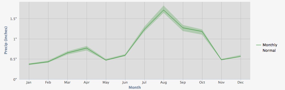
I’ve got 13 years of precip data for my house, first as part of the Albuquerque National Weather Service’s CityNet program, and now as a CoCoRaHS observer. But 13 years is too short a time period to calculate a meaningful average. Now, thanks to the new PRISM data, I have a clearer idea of what the long term looks like in my neighborhood:

Average monthly precipitation, Altura Park neighborhood, Albuquerque

Average monthly precipitation, Altura Park neighborhood, Albuquerque

That’s a PRISM estimate of average monthly precip during the 1981-2010 period now in use for US “climate normals”. You can see that October is usually one of our wetter months, averaging 1.18 inch (3 cm). This year I had 0 inches (0 cm).

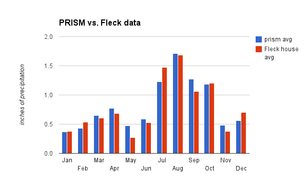
Here’s the PRISM data compared to my shorter record:

PRISM 1981-2000 averages compared to Fleck 1999-2012

PRISM 1981-2000 averages compared to Fleck 1999-2012

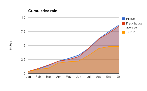
For the first ten months of the year:

  • 2012: 4.81 inches (12.2 cm)
  • my period of record average: 8.43 inches (21.4 cm)
  • prism average: 8.67 inches (22 cm)
Cumulative precip

Cumulative precip


on solving water problems

There’s a tendency, when confronted with water problems, to try to specify solutions: If only we’d junk those golf courses and stop watering our damn lawns so much! Why are we wasting our precious water growing alfalfa in the desert! We must reduce exports from the Sacramento-San Joaquin Delta! Water markets!

In a post last week, veteran Kansas water manager Wayne Bossert had a great summary of a talk by Bill Blomquist (student of and collaborator with the late Elinor Ostrom) that lists eight characteristics of successful efforts to share common pool resources. Notice that, rather that banning golf, this is about putting in place the institutional framework so folks can come up with workable and sustainable solutions (including, if they so desire, the decision to ban golf). As a water numbers nerd, my particular favorite is number 2:

Shared information. All the participants must be able to understand, transfer and communicate data, goals, interests, current use levels and all the other parameters needed for understanding the situation.

But if you’re in the midst of a tangled water policy/politics battle, the entire list is essential reading. How many item’s on Wayne’s list does your current water process have? If you don’t have ’em, it’s unlikely that you’re going to succeed at this, I fear.

A summary of Blomquist’s talk is here (pdf). A book worth reading on all of this is Ostrom’s Governing the Commons.

Coyotes and geese – the trajectories of our newly forming urban ecosystems

Canada geese seems especially fond of Albuquerque’s country club and the neighborhood around it. So it also seems likely, according to research into urban coyotes, that the skinny little dog-wolves are in this urban ecosystem mix:

Though urban coyotes do occasionally attack cats and dogs, far more often they avoid them. (Coyote attacks on people are even less common.) They also don’t rely on garbage, as urban scavengers like raccoons do. Instead, their diet seems heavy on rabbits, rats, mice, fruit, and goose eggs (geese being a surprisingly common pest in many big cities).

From a delightful little bit of business by Kim Tingley on the urban coyote.

Russian thistle and the American heartland

I’ve always known, in very general terms, that the tumbleweed is an interloper. But the story is better than I could possibly have hoped. From Tim Egan’s The Worst Hard Time (a book I’m just catching up with and wondering what took me so long):
[W]hen they boarded ships for America, the Germans from Russia carried with them seeds of turkey red – a hard winter wheat – and incidental thistle sewn into the pockets of their vests. It mean survival, an heorloom packet worth more than currency. The turkey red, short-stemmed and resistant to cold an drought, took so well to the land beyond the ninety-eighth meridian that agronomists were forced to rethink the predominant view that the Great American Desert was unsuited for agriculture. In Russia, it was the crop that allow the Germans to move out of the valleys and onto the hihher, drier farming ground of the steppe. The thistle came by accident, but it grew so fast it soon owned the West. In the Old World, thistle was called perekati-pole, which meant “roll-across-the-field.” In America, it was knonw as tumbleweed.

Tim Egan is a very good storyteller

On water and storytelling

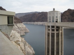
Hoover Dam and the bathtub ring

Hoover Dam and the bathtub ring

Water is at the core of a compelling human drama. Or perhaps dramas (plural). Yet the core issues, where the drama lies, are maddeningly difficult to, if I may share a personal journalist neologism, “storyize”. Cynthia Barnett, my favorite water writer, explains in the Los Angeles Times:

But we can’t see dried-out aquifers the way we could see black Dust Bowl storms in the 1930s or water pollution in the early 1970s. So we still pump with abandon to do things like soak the turf grass that covers 63,240 square miles of the nation. We flush toilets with this same fresh, potable water, after treating it at great expense to meet government standards for drinking.

We fill the fridge with beef, the shopping bags with cotton T’s, the gas tank with corn-made ethanol — all with little inkling of how we’re draining to extinction the Ogallala aquifer that irrigates a quarter of the nation’s agricultural harvest.

So Cynthia, as we all inevitably do, makes the pilgrimage to Lake Mead, and points out the “bathtub ring”:

Lake Mead is different. It’s one of the few places in the United States where the illusion of water abundance is being exposed for what it is: a beautiful bubble doomed to pop, just like other great national illusions — the unending bull market, say, or upward-only housing prices.

For 12 years, the nation’s largest reservoir has dropped steadily to reveal a calcium-carbonate bathtub ring, evidence of human folly and nature’s frailty — the over-allocation of the Colorado River and the drought still battering so much of the United States.

The problem, she found on her visit to Hoover Dam, is the tales we tell ourselves. I struggled with this a couple of years ago on my own similar pilgrimage:

We are sufficiently buffered by affluence that almost no one I talked to today had any inkling of what was going on. Just another tourist Sunday on Hoover Dam. The best I got was from one the folks in this picture, who were on a Sunday drive at one of the Lake Mead overlooks. One of them, a Las Vegas resident, knew the lake was way low, and said the solution was simple – somebody needs to have the political courage to make them release more water from Lake Powell, upstream.

I decided against explaining the Colorado River Compact, and the complex reservoir equalization rules in the 2007 shortage sharing agreement, that upper basin states are using less than their share of the river anyway, that Powell is low too, that it’s not that easy. But ultimately, I guess that’s what I have to figure out how to explain.

Consider this a call for better storytelling. Cynthia’s LA Times piece is a good place to start.

US-Mexico Colorado River Deal

Kudos to Chris Austin, who was out ahead of everyone else earlier this week in laying out the details of the pending US-Mexico Colorado River water deal. I encourage you to head over to Chris’s blog for more on the deal, which was first presented last Monday to the board of the Metropolitan Water District of Southern California, the first step in a rollout that’s now happening all across the seven US states that share the Colorado. Since Chris’s piece, some of the news types have jumped in, though Chris’s piece is the best explanation of what’s going on.

I’ll know a lot more next week, when New Mexico gets its briefing at a meeting of the state’s Interstate Stream Commission. But in brief, this has the potential to be an extremely important deal because of the way it extends the Colorado River’s complex accounting system across the US-Mexico border, in the process addressing one of the major unsettled package of questions regarding Colorado River management.

The underlying problem the negotiators have been trying to address is how to equitably share shortages between the United States and Mexico. The US-Mexico treaty of 1944 (pdf) calls for reduction of Mexico’s share of the river in the case of “extraordinary drought”:

In the event of extraordinary drought or serious accident to the irrigation system in the United States, thereby making it difficult for the United States to deliver the guaranteed quantity of 1,5000,000 acre-feet (1,850,234,000 cubic meters) a year, the water allotted to Mexico under subparagraph (a) of this Article will be reduced in the same proportion as consumptive uses in the United States are reduced.

But how “extraordinary drought” might be defined, and the details of how the shortage sharing contemplated in the treaty might be implemented, was left as an exercise for future generations. It’s taken a bit longer than I imagine anyone expected to get back to to it. Beyond the shortage/surplus management issue, the deal also appears to address a couple of major steps forward in trans-boundary river management, including the creation of a framework for Mexico’s storage of water in US reservoirs, and some management tweaks that seem aimed at providing environmental flows in the de-watered Colorado River delta.

For background on the outstanding issues, I recommend Jason Robinson’s “Respective Obligations of the Upper and Lower Basins Regarding the Delivery of Water to Mexico: A Review of Key Legal Issues” (pdf), a white paper produced with the University of Colorado School of Law Colorado River group.


Stuff I wrote elsewhere: Engineering nature at the Bosque del Apache

From the morning paper, a look at the wet bits and the dry bits at the Bosque del Apache National Wildlife Refuge during a drought, and the challenge of mimicking nature:

Some years, like this one, drought comes to the refuge in a way that matches what we would have seen in a drought year a century ago. The beloved “boardwalk pond” at the refuge’s south end, home to cormorants and pelicans, was nothing but cracked mud when Mize took Brose and I on a tour last week. There was so little water in the ditch feeding pond this year that it finally just dried up, Mize said.

To my look of concern, Mize responded with a wildlife manager’s calm equanimity: “Healthy wetlands are fluctuating wetlands,” he explained. “Drought is a natural occurrence. Our landscape evolved with drought.”

To the south, Mize showed us how refuge crews had cleared out unnatural thick stands of cattail that had choked one of the refuge’s ponds, taking advantage of drought to bring the system back to a more “natural” state. The pond is in an old river channel that in some years would have dried in drought, and in other years been ripped clear by spring floods. A consistent water supply has, in the past, given the pond a spectacular stand of cattails – lovely, but requiring human intervention to get “nature” back on an even keel.

Hence the dried-up pond and ripped-out cattails. “This is what Mother Nature would have done,” Mize said.


Transborder conflict on the Mekong

I’m generally sympathetic to the notion that transboundary water conflicts are overrated, and that they often provide a framework for cooperation. Except when they don’t (from this week’s Economist):

The decision by Laos to push ahead with the giant Xayaburi dam makes it the first of what could prove to be a cascade of 11 proposed dams on the lower Mekong. Because the decision fails to take account of the consequences for downstream countries, it has raised tensions with neighbours. Having long pretended otherwise, the Lao government recently asserted that construction was forging ahead, and indeed was on schedule. That prompted a warning from the president of Vietnam, Truong Tan Sang, that “tensions over water resources are not only threatening economic growth in many countries, but also presenting a source of conflict”.

The core of the conflict is the freshwater fishery, one of the world’s largest, on which the Economist reports 65 million poor folk depend for protein.