So my dad died, and I wrote these things that are helping me feel a little better

I sat for a really long time with my Dad Sunday afternoon. His labored breathing was like a metronome, a weird combination of great labor and steady rhythm. His eyes were vacantly half open, and it’s reasonable to assume (I did at the time) that he had no idea I was there. It was lunchtime, and I was headed to see my mom, only intending to stop in with dad for a moment, because the death bed vigil for a man no longer there seemed ridiculous. But I sat, for just a minute.

Every so often there would be a hitch in his breathing, and I would look up quickly, into his eyes, hoping it was the end. But then the metronome would resume.

Once I’d been there an hour, I couldn’t leave. It wasn’t a painful afternoon or a pleasant afternoon, it was simply time suspended, a day with me in my mind and Dad in his. But as the sun started to fade, I realized that if there was any light making through Dad’s sunken, half-opened eyes to the brain behind, it was likely the last fading sunlight my father would ever see.

Sharing that moment suddenly mattered to me a great deal. He was an artist. The light was the thing:

Malfunction has a way of clarifying function. As dementia etched away my father’s brain, he lost the ability to draw and paint. But from the window of the Albuquerque apartment where he and my mother have lived in recent years, he could look out at the Sandia-Manzano mountain chain and just watch that great big New Mexico sky. He didn’t know much, but in the moment, he always knew what the clouds were doing.

I’d take him for a drive, and we would stop for a short walk (it was all he could do) in the bosque. He would stare at the twisting forms of the old cottonwoods and talk about them, pointing and composing paintings in his mind.

The project now, beyond the relief of it being over, is to carve my way back through the last half dozen years of dementia and rebuild the memory of something else.
 

The shortcomings of the Colorado train wreck metaphor

Hannah Holm of Colorado Mesa University had a good piece earlier this month in the Grand Junction Free Press outlining the future risks facing Colorado River water users and managers:

A heavy train is moving at 5 miles per hour toward… a cliff? A collision? And how far away might this unknown calamity be?

These were the images and questions I was left with at the Upper Colorado River Basin Water Conference hosted by the Water Center at Colorado Mesa University Nov. 8-9. I deeply appreciate the fact that our presenters used such colorful language!

The heavy train is our collective use of Colorado River water, and the calamity we are facing is our potential inability to balance supply and demand in an orderly way. According to a nearly complete study on Colorado River Basin water supply and demand coordinated by the US Bureau of Reclamation, we’ve passed the point where use of the basin’s water resources exceeds the quantity provided by Mother Nature. The fact that the train wreck isn’t here yet is because of big reservoirs that store water from year to year. Climate change shows no sign of helping: The mean of all the models used in the bureau study indicates higher variability from year to year and a decline in average natural flows at Lee Ferry of 9% by 2060.

Holm’s summary of the issues is spot on. But the train wreck/cliff metaphor seems wrong to me, in ways that I fear are skewing the basin water policy and politics discussion. The train wreck or cliff metaphor suggests that the problem manifests itself as an abrupt calamity – from her lumbering 5 miles per hour to full stop crash (or over the cliff). But the nature of the problem, and therefore the needed discussion about potential solutions, is not like that.

We will not go from full water supplies, which everyone largely receives now, to zero in an instant. We will go from full water supplies to less-than-full water supplies. The policy approach to avoiding a crash is different from the policy approach to preparing for the allocation of growing shortage/shrinking supply.

atmospheric river headed California way

I love the way “atmospheric river” has now entered the public weather discussion lexicon:

Enjoy the dry, cool days that mark the start of this week in the Sacramento area. Then get ready for an “atmospheric river” late in the week that will bring perhaps 3 inches of rain to the Valley, the National Weather Service said Sunday.

ARs (they evening have an initialism!) are all the rage in weather and water management circles in the west these days. Some material from the Inkstain back catalog:

More on the definition of “drought”: a dry spot

Another episode in my effort to explore the meaning of “drought” by way of example.

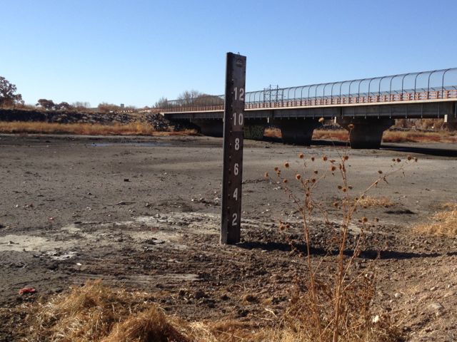
Tramway wetland, November 2012

Tramway wetland, November 2012

Up on Albuquerque’s north side is a spot the birders call the “Tramway wetland”*. It’s the spot where the main flood control channel for much of Albuquerque slows before entering the Rio Grande. The local flood control authority has designed a wide shallows to catch the water and allow grody gunk to settle out, to reduce the amount of urban runoff contamination entering the river. It usually smells bad and looks even worse, but the birds, especially migrating shorebirds, love it because it’s one of the few large areas of shallow water in a stretch of river that once would have had much shallow water, before humans used dams and levees to break it of its meandering ways.

More than once I have taken my sandwich and binoculars to the Tramway wetland, which is not far from my office, at lunch. Smell notwithstanding, the birding is great. I’ve seen 50 species there, and the eBird reports for the site list 191 species.

I was out on Friday looking for a rare dunlin that several birders had spotted, and was amazed at how little water there was in the wetland. Just a few pools in the deepest spots, far less than usual. There are two things likely going on here. The first is “drought” by the conventional definition: not a whole lot of rain. Since Sept. 1, we’ve had just 0.55 inches (1.4 cm) of rain at the rain gauge at the airport. Average for  this stretch is 2.58 inches (6.55 cm). So there’s less rain flowing down the flood control system and out into the wetland.

The second effect is distinctly anthropogenic.

In addition to rain, the flood control system gets some water when Albuquerque’s municipal water agency starts up one of its big groundwater pumps. They flush an initial pulse of water into the flood control system, which makes its way down to the wetland. Albuquerque has shifted some of its demand to surface water, using a dam along the Rio Grande to divert water for municipal use. This seems to mean less pump flushing, and therefore less “wasted” water flowing into the Tramway wetland.

Here, I think, there is drought.

There were still a dozen sandhill cranes, drought or not, poking around in the barely-wetland, plus a great blue heron, some odds and ends of ducks that I really felt sorry for poking around in the mudholes that are left. And maybe the dunlin. Couldn’t be sure as it took flight, so I didn’t add it to my life list.

* The bridge in the picture is actually Fourth Street NW, or maybe Second Street NW (a confusing intersection), which turns into Roy Road, which eventually turns into the road we call Tramway. Don’t ask me why it’s not therefore the “Fourth Street wetland”. I just do as I’m told.

the importance of music education

Once, while a young teen, I spotted a house on fire while dad was driving me home from my bassoon lesson. I alerted the residents, who were unaware that their roof had caught fire. It was a relatively modest fire, and firefighters were able to quickly extinguish it without major damage to the house or injury to those inside.

I consider this a good example of the importance of music education.


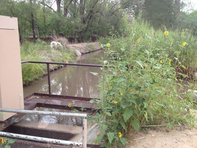
Where does this fit into our definition of “drought”?

This is August 2012 along the Duranes ditch in Albuquerque’s north valley. The ditch on the left is relatively new. The spur to the right, obscured by the sunflowers, has been in continuous use for more than 300 years. The previous 24 months for this climate division had been the second driest such stretch on record, going back to the 1890s. Yet water management decisions – storage of waster upstream for release during the depth of summer, importation of water via the San Juan-Chama Project from the Colorado River Basin, a distributary network that fans the river out across the Rio Grande Valley floor – made this spot cool and lush in the heat of a droughty summer.

What does this contribute to our understanding of “drought”?

Duranes Ditch, August 2012

Duranes Ditch, August 2012

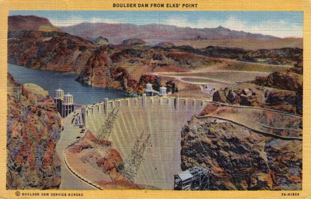
Boulder Dam, circa 1946: “a lot of propoganda for Daddy to read”

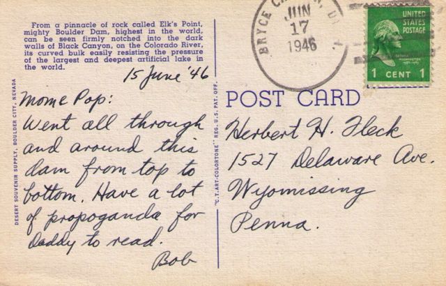
My sister, Lisa, found a box of Dad’s old postcards over the weekend, including a number he had sent during a trip out west in 1946. He’d just gotten out of the Army, a Pennsylvania kid wandering the landscape that would later animate his art and become our home. There was this, to his parents back in Wyomissing, from his tour of Boulder Dam:

Boulder Dam from Elks' Point

Boulder Dam from Elks’ Point

"a lot of propoganda for Daddy to read"

“a lot of propoganda for Daddy to read”


15 June ’46

Mom & Pop:

Went all through and around this dam from top to bottom. Have a lot of propoganda (sic) for Daddy to read.

Bob

measuring drought – the right tool for the job

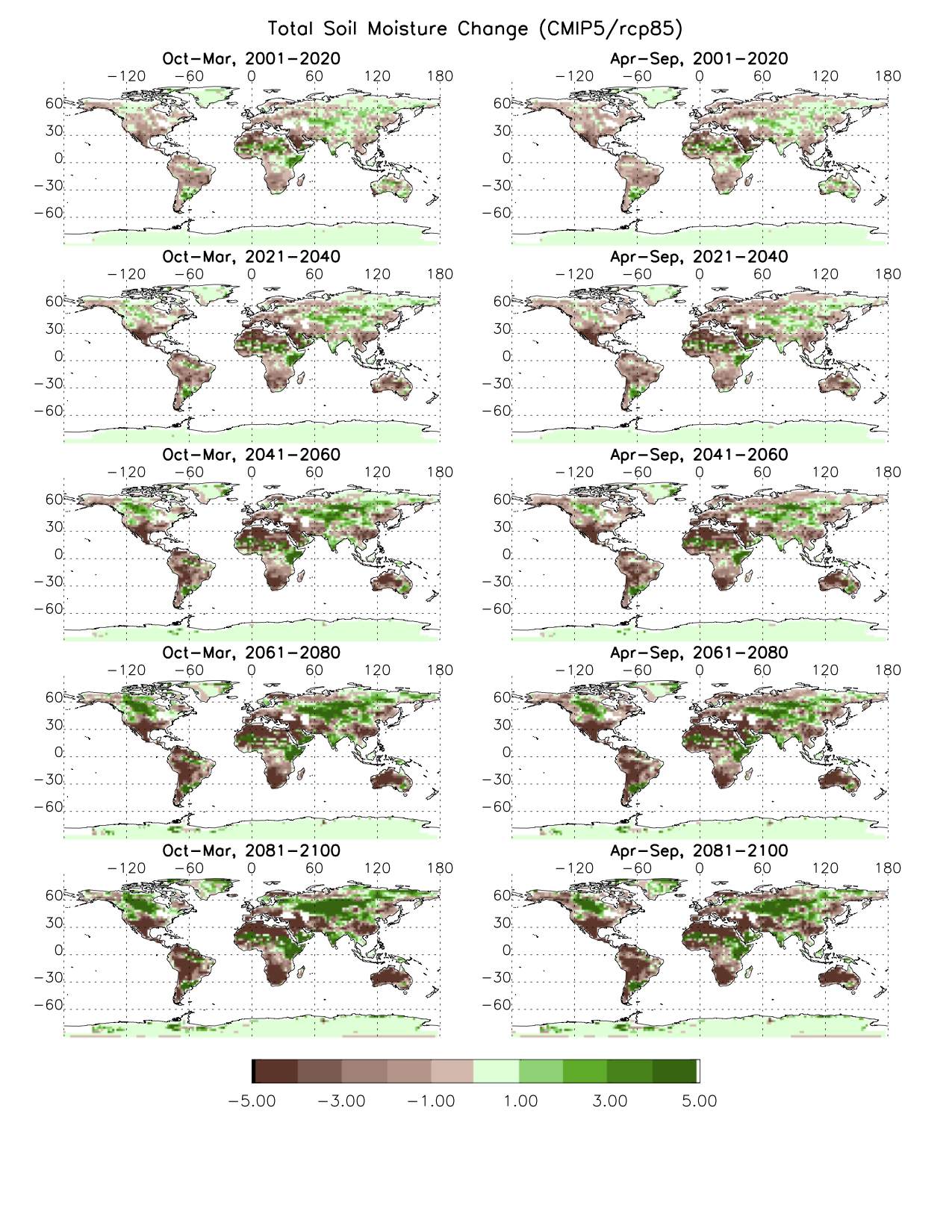
Richard Seager’s widely cited 2007 paper projecting “an Imminent Transition to a More Arid Climate in Southwestern North America”  did not use the Palmer Drought Severity Index. His work relies on a calculation of precipitation minus evaporation (P – E) to determine the extent and trend of drying under a changing climate. In response to my recent inquiries about the flurry of news involving the question of whether the Palmer shows any global drought trend (background here, here, here) Seager emailed this (shared with permission, linkage added by me, with the plot to which he refers below, click to biggen):

PDSI should not be used for future climate change, pure and simple. The Sheffield paper redoes in many ways a 2008 paper by Eleanor Burke (UK Met. Office) that made the same point about the pitfalls of the simple PET calculations in the PDSI calculation. Indeed Chris Milly has recently made the same point. The problem with the Sheffield paper is it then leaves the impression that there is little to worry about. Not so. Here is an unpublished plot of change in soil moisture for summer and winter half years for the CMIP5 ensemble with the rcp85 scenario – I made % change maps for each model and then averaged the %s to make the multimodel ensemble mean. Bottom line – you still see the widespread drying that PDSI trends indicate though a 10% drop in soil moisture is probably less dramatic in appearance than -10 PDSI.

Global Drought Trends

Global Drought Trends, courtesy Richard Seager


stuff I wrote elsewhere: “Depends on what you mean by ‘drought.'”

From the morning paper, an exploration of what we mean by “drought”, with some stuff on the Sheffield Nature paper so talked recently in drought circles, along with the latest grim outlook:

“Drought,” University of Arizona research Gregg Garfin said, “is defined by its impacts.”

I realize this is a long-winded way of being very unhelpful to Ken, whose question started all my inquiries. My simpler answer, Ken is, “Depends on what you mean by ‘drought.’ ”


Stuff I wrote elsewhere: on drought metrics

From the work blog, some material from a discussion among drought researchers on the Sheffield Nature paper and the question of when the Palmer Drought Severity Index is or isn’t the right tool for the drought measurement job. Here’s Dave Gutzler:

Despite its many limitations PDSI is still a meaningful indicator of short term climate variability (interannual, maybe up to decadal, time scales). If you look at the uncertainties described by Sheffield et al., they are on scales of tenths of PDSI units on continental-global scales. Big short term droughts, which are primarily driven by precip anomalies, will be captured by PDSI regardless of the method used to describe evapotranspiration. For that matter, the magnitude of long-term change looking forward, associated with really big century scale temperature change, will show up as ‘long term drought’ regardless of the details of the PDSI calculation. That’s why so many different hydrologic indicators (streamflow, vapor pressure deficit, etc.) that do not incorporate similar debatable ET parameterizations all point in the same direction. And that’s why I don’t think the Sheffield paper should require us to reject the validity of the core conclusions presented in so many recent papers.