Water use in Indian Country

In the western United States, water use and water rights questions associated with Native American communities are a major factor in the region’s future. Under federal law, these communities are entitled to substantial but often unquantified amounts of water. Planning for the future often gets tangled up in these questions.

For example:

Not all tribes in the Basin have adjudicated rights or settlements covering all of their tribal lands. In Arizona, five federally recognized tribal governments do not currently have quantified water rights: the Havasupai Tribe, the Hualapai Tribe, the Kaibab Band of Paiute Indians, the Navajo Nation and the San Juan Paiute Tribe. An additional six tribes do not have adjudicated rights or settlements for at least some of their lands: the Hopi Tribe, the Pascua Yaqui Tribe, the San Carlos Apache Tribe, the Tohono O’odham Nation, the Tonto Apache Tribe, and the Yavapai-Apache Nation.

That’s from the Inter Tribal Council of Arizona’s comments (pdf here) on the US Bureau of Reclamation’s draft Colorado River Basin Water Supply and Demand Study. The ITCZ also make a salient point that never occurred to me regarding water consumption under various economic scenarios being considered:

[E]conomic hardship that depresses population growth and thus M&I water demand in the large cities may result in tribal members who were living in those cities and become unemployed moving back to their tribal homelands, increasing M&I water demand there.

SREX, slow journalism edition

Given the time scales associated with climate change and societal response, it seems perhaps best to wait to consume the new IPCC Special Report Managing the Risks of Extreme Events and Disasters to Advance Climate Change Adaptation (SREX) until it’s actually done. This seems especially true given its stated purpose:

The assessment concerns the interaction of climatic, environmental, and human factors that can lead to impacts and disasters, options for managing the risks posed by impacts and disasters, and the important role that non-climatic factors play in determining impacts.

Because managing those risks will likely have to be done on a local/local/regional/national scale, we need a lot more detail than that presented in the summary released Friday (pdf here) to actually make use of the thing. Its primary role now, it seems, is to fuel the usual climate wars feuds, though it seems to be profoundly useful in that regard. The echo chamber is loud this weekend.

That said, the summary does offer some interesting tidbits that will likely lead to useful reading once the full report is out:

It is likely that there has been a poleward shift in the main Northern and Southern Hemisphere extra-tropical storm tracks.

This is consistent with one of the components of drought discussions here in the southern tier of US states. But:

There is medium confidence that some regions of the world have experienced more intense and longer droughts, in particular in southern Europe and West Africa, but in some regions droughts have become less frequent, less intense, or shorter, e.g., in central North America and northwestern Australia.

So let’s talk again in February, shall we?

Not much river left

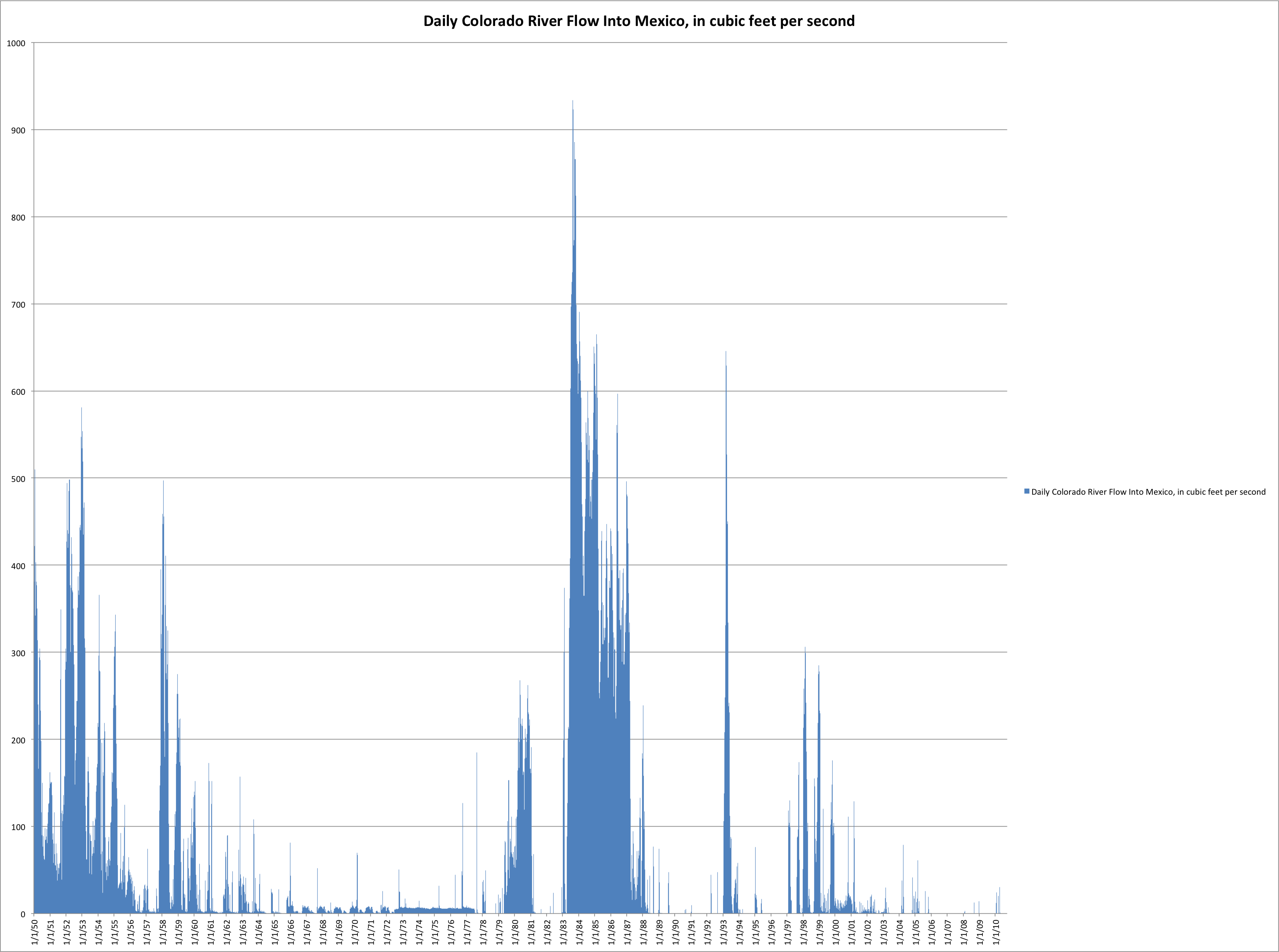
Back in the 1950s, the Colorado River, at least a bit of it, used to regularly reach the “Southern International Boundary” – the river bed near San Luis where it stops being the US-Mexico border and travels solely in Mexico. Even during the driest bits, when Lake Mead was dropping during the late ’50s, at least a little water slipped by.

In the mid-’80s, the great floods that nearly cost us Glen Canyon Dam and filed Mead to the brim meant that “extra” waster slopping in the system cascaded down to the Colorado River Delta. By the mid-1990s, it was less common. Today? Pretty much nada:

Colorado River Flow Into Mexico

Colorado River Flow Into Mexico

From the Yuma Sun:

“The riverbed is completely dry. There’s no flow coming down into Mexico.”

Data courtesy International Boundary and Water Commission

Hand drawn maps

I first noticed it while I was out in the mountains of northern New Mexico back in the mid-1990s with Karl Karlstrom, a University of New Mexico geologist. I had tagged along on a summer field camp mapping exercise for a feature I was doing, and spent a good part of the day shadowing Karl and some of his students as they mapped a tangled section of old basement rock.
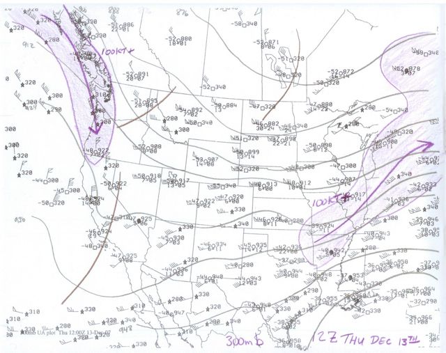
Hand Drawn Weather Map

Hand Drawn Weather Map

This will be familiar to earth scientists, but was a revelation to me – the way Karl with his little pouch of colored pencils sketched in the rock units as he walked. He was not simply recording data. The act of drawing was part of his construction of a mental model.

I’ve seen it again many times, most notably among meteorologists. In my book*, there’s a scene with forecaster Ken Drozd sketching out the movement of a storm across his daily weather map. Charlie Liles, the retired head of the Albuquerque Weather Service office, used to make these wonderful colored drought maps by hand.

Tom Pagano, the roving river forecaster, has a thoughtful explanation today on his blog about why it’s done this way:

Even though they have access to some of the largest supercomputers in the world, somewhere right now a meteorologist is sitting down with a set of colored pencils to hand-draw air pressure levels on a blank map. This is a generational thing, for sure, younger forecasters (myself included) often preferred to automate things and spend more time, for example, actually getting to eat lunch.

However, it is a meditation on the data. They spend time with their problem, giving it attention and thinking about its parts. As they draw, they consider each individual curve and line, while also subconsciously (or even consciously) marinating in the meaning of the broader pattern of the data. They are developing and exercising their intuition.

I’ve wondered too about whether it’s a generational thing. For the meteorologists, geologists and anyone else in the audience, do you sketch out your work by hand?

* Ideal for that bright youngster on your holiday shopping list!

The economic origins of wildlife refuges

In his richly detailed The Fall and Rise of the Wetlands of California’s Great Central Valley, Philip Garone explains a bit about the origin of wildlife refuges that I never knew:

During the early decades of the twentieth century, much of the Sacramento Valley was converted to profitable rice production. However, because the valley’s natural wetlands had been reclaimed, crop depredations that followed led to a crescendo of calls by the same farmers who had benefited from the valley’s reclamation to create wetland refuges in the valley. Some of the earliest motivations behind the creation of these refuges in the Sacramento Valley stemmed, therefore, more from economic interests  than from an ecological awareness of the importance of wetlands….

The sound of bark beetles

A Great Aridness

A Great Aridness

I’m thinkin’ you’ll want to head out to your favorite local bookstore and buy Bill deBuys’ A Great Aridness. It’s full of stuff like this, on the dry winter of 2001-02, when a bear came out of hibernation early because it was so warm and ransacked deBuys’ yard in search of something to eat:
That winter was a bad one for the bear, but a good one for the bark beetles, and once spring came, bringing weather so hot and dry the pastures never greened, you could walk among the piñons and hear a faint mechanical drone, as of a thousand tiny chisels rhythmically chipping away. It was hordes of beetles, tunneling and feeding.

I admit I was skeptical, but when I related deBuys’ account to a couple of northern New Mexico denizens, one an actual tree scientist, they said it’s true. When it’s scary warm and dry like that, they both told me, if you’re really quiet in the woods, you can hear ’em.

Creepy.

Stuff I wrote elsewhere: megadrought

Because it’s hard to resist the word “megadrought” – or, frankly, the concept:

Tree rings from the headwaters of the Rio Grande show a 50-year drought from 122 to 172 AD, suggesting that “megadroughts” may be a recurring feature of the region’s climate, according to new research by a University of Arizona team.

Scientists have long known about similar drought a thousand years later that has been linked to the end of the early Native American culture of Chaco Canyon and the Four Corners area. But it was never clear whether that drought was unique.

The new evidence, being published in the journal Geophysical Research Letters, comes from a grove of bristlecone pine found by University of Arizona graduate student Cody Routson in the mountains near Summitville, Colo. He initially spotted the trees through binoculars during the summer of 2007, and returned in later years to take samples used to show the trees’ year-by-year growth.

Plus, I have an inordinate fondness for the tales tree rings tell.

Stuff I wrote elsewhere: the endangered species act process brokenness

Thrown on driveways this morning, my effort to explain why I think the endangered species act process, as it relates to the silver minnow on the Rio Grande, is broken:

If you believe those who argue we are overusing water in the Middle Rio Grande Valley and headed for a crash (and there’s good data to support that position), it’s likely the problem will first show up in the river itself, as we take out too much surface and groundwater and leave the Rio Grande dry.

The first specific legal and regulatory manifestation of that problem would be a lack of water to meet Endangered Species Act requirements for the Rio Grande silvery minnow.

Farmers and cities will get their water while the Rio Grande goes dry, until someone – federal regulators or an environmentalist with a lawsuit – steps in.

The cliche is to call the minnow a “canary in a coal mine,” a sign of a crashing ecosystem. But it’s also a canary for our water supply problems. As a result, as often happens around the West, society ends up using the Endangered Species Act as a sort of de facto water policy management tool. When water runs short, who has to give some up to keep our rivers wet? We use the ESA to decide that question.

the problem with living in good times

White, Yampa, and Little Snake Rivers

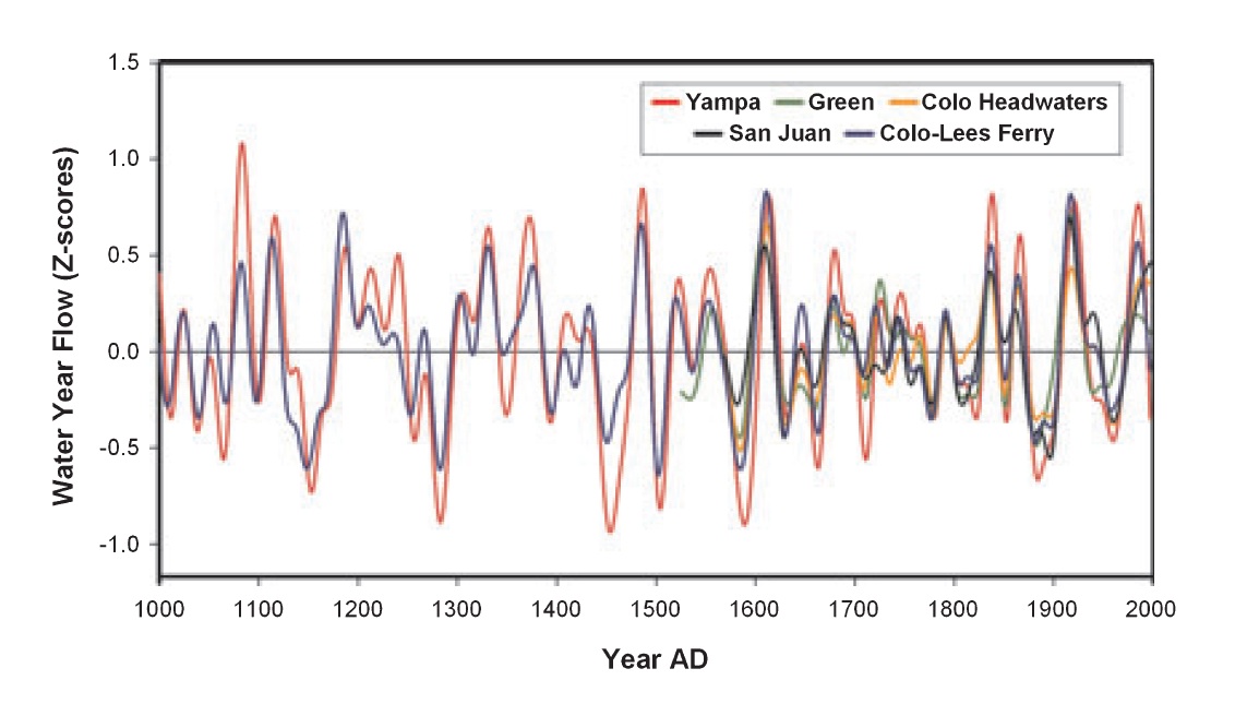
1,000 years of runoff on the White, Yampa, and Little Snake Rivers

Those pesky tree ring scientists are at it again, spoiling a perfectly good party.

Stephen Gray and colleagues have taken a dig into runoff over the last 1,000 years on three major Colorado River tributaries, adding a new level of granular detail to something that already seemed apparent: Runoff during the 20th century, when we built all this infrastructure and farms and cities, is a bit of an anomaly in the long run, and not in a good way:

[T]hese reconstructions point to the unusual wetness of the gage period, and the potential for recent observations to paint an overly optimistic picture of regional water supplies. The future of the Upper Colorado River will be determined by a combination of inherent hydroclimatic variability and a broad range of human-induced changes. It is then essential that regional water managers, water users, and policy makers alike consider a broader range of hydroclimatic scenarios than is offered by the gage record alone.

Gray, Stephen T., Jeffrey J. Lukas, and Connie A. Woodhouse, 2011. Millennial-Length Records of Streamflow From Three Major Upper Colorado River Tributaries. Journal of the American Water Resources Association (JAWRA) 47(4):702-712. DOI: 10.1111/j.1752-1688.2011.00535.x