Does the Upper Colorado River Basin Routinely Take Shortages in Dry Years?

By John Fleck, Eric Kuhn, and Jack Schmidt

As stakeholders negotiate the current crisis on the Colorado River, we believe the representatives of the states of the Upper Basin – our states – are making a dangerous argument.

Their premise is simple. With deep cutbacks needed, the Upper Basin states argue that their part of the watershed already routinely suffers water supply shortages in dry years. Without the luxury of large reservoir storage along the rim of the watershed that might store excess runoff in wet years and supplement supplies in dry years, the argument goes, the Upper Basin is limited by the actual mountain snowpack in any given year.

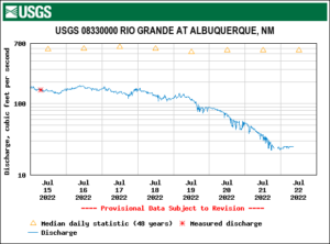
This is certainly true in many places. One of us (Fleck) lives in a community (Albuquerque, New Mexico) that has routinely seen supplies of trans-basin San Juan-Chama Project water shorted because of bad hydrology in a given year.

That is also the case for the oft-cited Dolores Water Conservancy District, which has junior water rights to the supply provided by McPhee Reservoir that is part of the Bureau of Reclamation’s Dolores Project. In contrast, the adjacent Montezuma Valley Irrigation Company has pre-Colorado River Compact water rights and its access to the same water source is relatively unlimited. The argument of the Upper Basin states about using less water in dry times applies in many local settings, especially in the local context of prior appropriation water rights. The argument is certainly logical.

But when one considers the regional scale of the entire Upper Basin, the argument is not supported by the data in the Bureau of Reclamation’s Consumptive Uses and Losses reports.

Our review of those data suggests that, on average, overall Upper Basin use is slightly greater in dry years, and less in wet years. While questions have long been raised about these data, they are the best that we have and, more importantly for this discussion, they are the data that the Upper Colorado River Commission has been using in support of its argument.

Here’s what the reports show for the 21st century concerning total Upper Basin consumptive Uses less net evaporation from the CRSP Initial Units (Lake Powell, Flaming Gorge, and the Aspinall Unit):

  • in the five driest years ( 2002, 2012, 2013, 2018, 2020), the average was 4.06 MAF/year.
  • In the five wettest years (2005, 2008, 2011, 2017, 2019), the average was 4.01 MAF/year.
  • in the middle 11 years (the remainder), the average was 3.81 MAF/year.

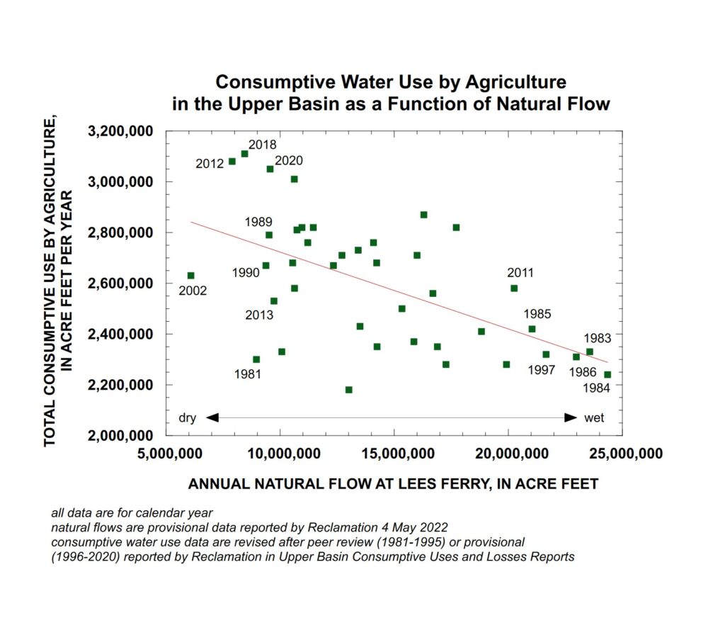
Upper Colorado River Basin agricultural water use in wetter and drier years. Graph by Jack Schmidt, Utah State University

Importantly, a scatter plot of Upper Basin agricultural water use since 1981 shows, in general, the opposite of what is being claimed. While agricultural use varies greatly from to year, in general, use has been greater in dry years and less in wet years.

In this plot, the estimated natural flow at Lees Ferry (a good representation of whether any individual year was wet or dry) is plotted against the summed agricultural use of water by all of the Upper Basin states.  This simple analysis provides results counter to the assertion of the Upper Colorado River Commission in the sense that agricultural use of water was greater in years of low natural flow at Lees Ferry and was less in years of high natural flow at Lees Ferry. Thus, this simple relationship indicates that agriculture uses less water in wet years and more water in dry years, which is exactly the opposite of the assertion by the Upper Basin community.

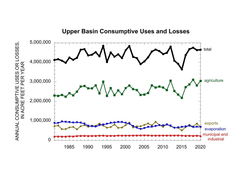
Upper Colorado River Basin water use over time. Graph by Jack Schmidt, Utah State University, based on USBR Consumptive Uses and Losses Reports

Another way of looking at this question is to consider the long term temporal trend. If the Upper Basin’s argument was correct, we would see a decline in agricultural water use in the 21st century, because the river’s flow shrank during the aridification of the 21st century. However, use has not decreased.

There are important nuances in the data. In the second year of some consecutive dry years like 2012-2013, the Upper Basin’s total consumptive use drops significantly, perhaps because local storage is depleted in the first year and doesn’t fully refill in the second year. This may be the situation in 2020-2021 as well.

Why do we view the argument as dangerous? Because Lower Basin interests can do the same math we have. They almost certainly already have. That leaves the Upper Basin with a fragile foundation for entering the negotiations over the compromises that are certain to be needed to modify the Colorado River’s allocation rules in the face of climate change.

Authors:

  • John Fleck is Writer in Residence at the Utton Transboundary Resources Center, University of New Mexico School of Law
  • Eric Kuhn is retired general manager of the Colorado River Water Conservation District based in Glenwood Springs, Colorado, and spent 37 years on the Engineering Committee of the Upper Colorado River Commission
  • Jack Schmidt is Professor of Watershed Sciences and director of the Future of the Colorado River Project at Utah State University

For the first time in four decades, the Rio Grande through Albuquerque is dry

A drying Rio Grande in Albuquerque’s South Valley. July 22, 2022, photo by John Fleck

For the first time in ~40 years (? – see below) New Mexico’s Rio Grande has “broken” – is no longer flowing – in what we call “the Albuquerque reach”.

The river dries not with a bang, but with a muddy whimper and the dawn serenade of awakening birds.

Science watches a river die – the USGS gage on the Rio Grande at Central in Albuquerque

Battered by 100-degree days, with storage above us running out, the river through town has been collapsing all week. When the flow at the Central Avenue Bridge dropped to 50 cfs Wednesday, I made an after-dinner dash to look. After getting word via a friend who had been on a briefing call yesterday that drying was now “imminent”, I got up early, loaded the bike into the Subaru and drove to the South Valley.

Rivers dry from downstream up, and I’d already scouted a path in through the willow thickets behind Harrison Middle School, knowing the drying would start there. Downstream from that point, the Rio Grande gets a break – 75 cfs from Albuquerque’s wastewater treatment plant, a weird way to rejuvenate a dying stream.

My best guess based on the gages is that the “drying” happened some time yesterday. It’s a weird word, because it’s still a lovely puddly mess of mud. But there is no longer water flowing from one puddle to the next. The official word this morning is that there’s a half a mile of drying, which puts the dry stretch starting somewhere around the Rio Bravo bridge (for locals who wanna go see for themselves).

The “bosque”, as we call our riparian forest, is lovely and thick down there, and I had to walk-a-bike quite a few times to push my way through sandy, narrow old foot paths choked with willows to get to the river.

That’s part of what’s weird about this, because what I’m calling “the river” for the purposes of this post is really the surface manifestation of a much more complex hydrologic system, and a big part of the work I’m now doing for the new book bids us to think more broadly about what we mean by “river” here.

The willows and cottonwoods were green and lush. They’ve got roots that easily tap into a shallow aquifer, the “subflow” part of the river. And where the river once spread on its own across a broad flood plain, we now do the job manually with a network of ditches and drains, some of which still had water in them this morning. Along the east side, for example, while the surface manifestation of the Rio Grande itself is now dry, the Albuquerque Drain (really more irrigation main here than “drain”) is flowing today at 120 cfs.

This is a function of our community values. We created an institution a century ago to drain the swampy valley floor and manage a network of irrigation ditches where the river once flowed out on its own (read our new book! as soon as we write it!), and it is functioning as intended.

Even as the river’s surface flows dry, the ditches are drying too. Irrigators have been warned that absent rain, there will be very little to water their land very soon. South Valley horse owners (the biggest consumers of irrigated stuff around here – the horses, I mean) will be buying hay. It’s a very dry year, the agony of climate change dumped atop some water management chaos.

And for the first time in a long time, the river itself here – the part above the ground and between the levees – is going dry.

A note on how long it has been since this has happened here.

The standard line we’ve all been using is that this is “the first time the river has dried in the Albuquerque reach since 1983.”

I’ve heard that said repeatedly by my water manager friends, but I’ve not chased down how we know that.

What I do know with certainty is that drying, once far more common in this reach of the river because of the way irrigation was managed in The Old Days (divert the whole river, run the ditches full, irrigate whenever you want) has been rare since the late 1970s.

Here’s a graph of drying days at the Central Avenue gage, where we have records back to the mid-1960s:

Rio Grande drying


The poets down here don’t write nothin’ at all, they just stand back and let it all be.

Colorado has no plans to make additional cuts to water use next year to meet the Bureau of Reclamation’s demand to conserve millions of acre-feet of water, a step needed to preserve power production in Lake Powell and Lake Mead.

Instead, Colorado officials insist that other states should do the cutting.

“I think that at this point, we stand ready to hear what the Lower Basin has in mind,” said Amy Ostdiek, a section chief with the Colorado Water Conservation Board.

Source.

“You can stand on your legal theories and watch the system crash,” (Anne Castle) said. “But that doesn’t help anybody.”

Source.

“a veritable garden spot”

Albuquerque’s “Barr Irrigation District”, circa July 2022

Barr Irrigation District

The home of the ill-fated “Barr Irrigation District” is not one of Albuquerque’s scenic destinations.

Perched on low sand hills between Albuquerque’s soft industrial underbelly and the city’s “Sunport” (our marketing appellation for what a lesser metropolis might call an “airport”), the old irrigation district land is today home to an interstate, a power plant, a couple petroleum tank farms, junkyards, and “Fresh and Clean Portable Restrooms”.

But in 1912, when the Barr Irrigation District first glimmered in the eyes of Albuquerque boosters, it was going to “transform the central Rio Grande valley into a veritable garden spot.” A thousand acres of crops, “marketed here for home consumption and shipment” would be “the best thing for Albuquerque’s growth and prosperity” – “a rich agricultural district with this city as the center and distributing point”. (Albuquerque Journal, Jan. 13, 1912)

All that was needed was water, and H.J. Buell, an “irrigation expert” down from Denver, had the answer – “a pumping system operated by electric power”!

“Water in abundance is found at comparatively shallow depth,” the Albuquerque Journal explained in January 1912. The Journal suggested a great “free water” racket to support the enterprise: farmers could sell their rights to surface water flowing through ditches “for a substantial sum” and use the money to build more pumps and irrigate more land. (Research note: This is one of the earliest references I’ve found to sale of water rights in the valley as an economic scheme.)

As near as we can tell, a few farmers did, in fact, sign up with Buell and pump water up to the sandhills. But as the Middle Rio Grande Conservancy District made farming in the valley below more attractive by draining swampland and re-jiggering the irrigation works, the project faltered. In the ensuing years, the low sandhill area was institionally reconfigured as the ~800-ish acre “Barr Irrigation District”, the the scheme shifted from pumping groundwater to making the area an extension of the Conservancy District’s existing valley floor irrigation system, pumping ditch water instead.

Like much about the valley’s irrigation schemes, success hinged on find a source of “other people’s money” to pay for it, and when efforts at procuring federal cash failed in the 1930s, the Barr Irrigation District faded from view.

Themes from the book

Two holiday weekend diversions took me into this part of the valley south of Albuquerque – me on a Canada Day weekend bike ride with Scot, and Bob in the archives after I returned from the ride and peppered him with questions. (Having a Regents Professor with mad skills as my “research assistant” for the new book is a pretty sweet perk of the current project. Plus #GeographyByBike – Scot’s importance as a research assistant in this part of the project is crucial.)

Down the hill from the never-realized Barr Irrigation District is the Barr Canal. It’s one of those Middle Rio Grande Conservancy District ditches that has a distinctly “modern” feel – the sharp straight lines of 1920s engineering superimposed over the meanders that went before.

When I say this part of our valley might not qualify as one of Albuquerque’s scenic destinations, I say so with tongue slightly askew. It’s actually an aesthetically fascinating area, a strange mix of Charles Sheeler-esque industrial majesty, movie-set post-apocalyptic junk, and farm. My crazy GPS bike riding map games suggested this was an under-explored piece of Albuquerque, a shortcoming that, with Scot’s help, I’m working to correct.

This part of the junkyard included piles of junked dumpsters. It looked like the graffiti was applied before the container’s arrival.

Scot and I this weekend rode up the Barr from the south, where it cuts through the Albuquerque Metal Recycling yards. ‘Round the back, the Barr splits the main recycling yard from its more post-apocalyptic back acres, the place where the junk yard seems to junk its junk.

It includes trashed trucks from UPS and Federal Express, and (my favorite part) an area devoted to junked dumpsters.

Mostly it was just a bike ride, but when we’re riding the valley floor, there really is no such thing as “just a bike ride”. I’m puzzling out the geography of the valley floor – why some places are homes and twisty streets, some areas were left as big farm fields, and some places got stuck with the city’s junkyards.

In his fascinating new book Tributary Voices, Paul Formisano takes on the stories we’ve been telling ourselves about the colonial watering of the west:

Striving to return to the garden once lost through the Fall, nineteenth-century beliefs about the arid West dictated man’s divine right to drastically alter the region for the onward march of progress and civilization.

Standing alongside Frederick Jackson Turner’s frontier myth, the garden myth spilled awkwardly into 20th century Albuquerque in places like the Barr Irrigation District.

I don’t know that the Barr and this stretch of Albuquerque’s southeast valley will make it into the new book Bob and I are writing (Ribbons of Green: The Rio Grande and the Making of a Modern American City, available several years from now, once we finish writing it, at a fine bookseller near you). We have too many stories already. But it illustrates a bunch of our central themes.

  • The myths of agriculture: Albuquerque and the surrounding Rio Grande Valley may never have had the dreamy agricultural past to which the boosters claimed they wanted to return, and to which the modern water policy boosters still often mythologize. But true or not, the vision shaped the city we became.
  • The role of institutions: In addition to the Barr Irrigation District, this part of the valley was home to the brief life of something called the “South Albuquerque Drainage District”. Formed in 1920, the District never seems to have gotten off the ground, and was subsumed into the Middle Rio Grande Conservancy District when it was formed in the years that followed. In developing our water management institutions, scale mattered.
  • The greening (junkyarding?) of the valley floor: The once-swampy lowlands of the valley floor were changed forever when the Conservancy District’s draglines sliced through in the 1930s, digging the low-lying ditches we call “drains” that were the district’s most important accomplishment.

The greening of the valley floor

Junkyards and farms along the Barr Canal, Albuquerque, 2022

This stretch of the Barr is my new favorite Albuquerque ditchbank ride (sorry, Los Griegos!).

Up from Rossmoor Road, passage through the junkyard and into the old Schwartzman farm is weird. Smashed cars being ground up for scrap to right of us, scrapped UPS trucks to the left of us, the Barr in between running full and happy right now, and up ahead, one of the last big commercial alfalfa fields in the county being cut.

On lands that seem not to have been farmed or even settled during Albuquerque’s colonial period, the farm and the junkyard sit on land that was an old stockyard and meat processing plant run until the early 1980s by the Schwartzman family. While the sandy soil and lack of drainage may have made this part of the valley relatively less attractive than Astrisco and surrounding villages across the river, the railyards, and then drainage, made the area ideal for Albuquerque’s industrial underbelly.

The Schwartzman land has been slowly but surely carved up in recent decades, but when Scot and I left the awkward confines of the junkyards onto an open ditchbank flanked by fields, a farmer was still on the land, spending their Canada Day holiday weekend methodically cutting hay.

Verdant

Rio Grande at Albuquerque, June 20, 2022

Where peaceful Rivers soft and slow
Amid the verdant Landskip flow.

Addison

My friend Mary Harner, who loves and thinks about rivers more/better than anyone I know, is in town.

We found time this morning for a walk along our shared passion, the Rio Grande. After 78 days without rain, the monsoon bloomed on Friday, and it’s been raining since.

I sat on a downed snag poking over a muddy river as we talked. I picked idly at the moist, crumbling top layer of wood.

Moist.

Smelled good.

With Eric Kuhn’s help, I found a (nearly) full Colorado River Basin reservoir!

Dillon Reservoir, June 15, 2022

When Eric and I converge on a meeting, there’s always the “Are you gonna bring a bike?” conversation.

This week it’s the Getches-Wilkinson Center’s Annual Colorado River conference, and the bike ride was a loop around Denver Water’s Dillon Reservoir, on the Blue River.

It’s nearly full. The creeks feeding it were running. There was a cool breeze.

In the midst of the sturm und drang, it was lovely.

Touton: On the Colorado River, we need to cut an additional 2 to 4 million acre feet of use. Now.

I’ll let Bureau of Reclamation Commissioner Camille Calimlin Touton explain this:

In the Colorado River Basin more conservation and demand management are needed in addition to the actions already underway. Between 2 and 4 million acre feet of additional conservation is needed just to protect critical elevations in 2023. (emphasis added)

That’s what Commissioner Touton said in a Congressional hearing today (her comments start around minute 32 in the video embedded here).

That is a stunning number. Last December, the basin leadership gathered on a Las Vegas stage at the Colorado River Water Users Association to roll out their “500+ plan.” That set a notional goal of 500,000 acre feet in conserved Lower Colorado River Basin water, and the Lower Basin states are having a hard time coming up with that. 2 million is a lot bigger than 500 thousand. 4 million is a lot bigger than 2 million.

In 2023, which is effectively now.

Touton gave the usual nod to collaborative engagement with states and tribes. But she also made a pointed threat:

It is in our authorities to act unilaterally to protect the system, and we will protect the system. (I added the emphasis, but listen for yourself. I think she did too.)


As Albuquerque’s Rio Grande dries, is the system simply functioning as we intended?

The Chamisal Lateral, a shady oasis in Los Ranchos de Albuquerque.

In a sad but important way, the disastrous 2022 water year has been a gift to the writer, and I’m spending as much time as I can in reporter mode, sussing out the stories of this remarkable year.

In the new book we’re writing, Bob Berrens and I are trying to make sense of the decisions Albuquerque has made over the last century to live on the Rio Grande Valley floor – we shape river, and  the river shapes us.

2022 is a test. There is less water, a lot less. What will we do? What will this place look like as climate change makes years like this less exception and more norm?

This morning’s bike ride took me through the middle of my hypothesis, a transect across the hydrogeography of Albuquerque – up the river valley through the community of Los Ranchos de Albuquerque, then out onto the riverside trails.

Los Ranchos was leafy and green. The riverside woods were parched, and the river itself, the part flowing between the levees, is at the lowest it’s been at this point in the year since 1989.

For those alarmed by the dropping river, and perhaps struck by the contrast with the buccolic, tree-lined Chamisal Lateral in the picture above, it’s worth considering why things are this way. Because it occurred to me as I enjoyed the shady lanes of Los Ranchos and then looked on at the dull agony of a drying river that this system is, in fact, working as designed.

We have a set of rules, encoded in state legislation and state and county implementation policy and therefore (I guess?) reflective of our collective values as a community that are designed to keep Los Ranchos green while allowing the river to go dry.

Rules as Water Management Design Principles Case 1: Domestic Wells

In 1953, the New Mexico legislature passed its first domestic well statute:

By reason of the varying amounts and time such water is used and the relatively small amounts of water consumed in the watering of livestock, in irrigation of not to exceed one [1] acre of noncommercial trees, lawn or garden; in household or other domestic use, …  the state engineer shall issue a permit to the applicant to so use the waters applied for.

The statute has changed over the years a bit, but its basic principle still applies. If you want to drill a domestic well at your house, you get to.

The New Mexico Office of the State Engineer does have the authority to declare something called a Domestic Well Management Area “when hydrologic conditions require added protections to prevent impairment to valid, existing surface water rights”, but that has not been done here. (Source, p. 33)

The result is a valley floor pockmarked with domestic well permits, allowing people to use water from the Albuquerque Bernalillo County Water Utility Authority for indoor use, and water their lovely yards from a shallow  domestic well. But remember, those shallow aquifers are in direct connection with the river. This is basically water coming straight out of the river.

If our rules are a codification of our values and intentions, it seems here that our intention is to keep the valley floor green in times of drought. If it isn’t, we need to change the rules.

Rules as Water Management Design Principles Case 2: The Agricultural Tax Break

Our crazy smart UNM Water Resources Program student Annalise Porter recently finished a relevant piece of work on the agricultural property tax break irrigators get on the valley floor here in the greater Albuquerque  metro area. Annalise defended in the spring, and is writing an expanded version of the project for a paper for publication. Soon! I think it’s really important stuff.

I rode down street after street today of affluent Los Ranchos homes colored pink on my version of Annalise’s maps – horse pastures, hayfields, one in sunflowers, all getting the tax break. This is not commercial agriculture, or “subsistence farming”, as one court ruling suggested was the intention of the 1967 state statute. These are hobby farms.

We have a set of rules – a state statute, implemented by our local county government, that is providing a financial incentive for this use of water, which Annalise estimates at ~10,000 acre feet per year in Bernalillo County.

Ribbons of Green

The title of the proto-book is Ribbons of Green, after a line in John Van Dyke’s oddly dishonest masterpiece The Desert. In our work, Bob and I are playing with a theme – that we make progress by thinking of “the river” as more than the narrow strip that flows between the levees. Our notion of the river includes the water we move out across the valley floor – the ditches, the shallow aquifers from which we pump to water valley yards, a culturally and biologically rich and complex system lain across a valley floor where an unencumbered river once spread spring floodwaters on its own.

It is interesting to think about what the ribbons will look like five years from now, or ten. Between the levees, in the river’s main channel, the die seems cast – we’ve apparently decided as a community that we’re fine with letting it dry. Maybe Texas will have a say in what comes next – sooner or later our Rio Grande Compact obligation to get water downstream to Texas will require us to put more water into the river channel, perhaps reducing the Los Ranchos blanket of green in the process. Or reducing the green somewhere. Riverside bosque? Farms?

Perhaps the struggle to help the dwindling Rio Grande silvery minnow, our Endangered Species icon, will lead to more water in the river and less in Los Ranchos (or less somewhere).

On my book research bike rides (such a racket!), I have come to stop random ditch walkers and yard waterers and engage them in idle conversation. In general, they love the green, have little idea where the water is coming from, and are delighted with the current situation.

The Compact or the Endangered Species Act as drivers may ultimately change things, but they are something different from our community values. As seen in the Water Management Design Principles above, we seem fine with spreading the green outside across the valley floor while letting the part of the river between the levees, its main channel, go dry.

If it were otherwise, we’d have different rules.

Ditch Lobster in a Drying Griegos Lateral

Ditch lobster in a drying Griegos Lateral, Albuquerque, June 9, 2022

Sorry I didn’t have the presence of mind to give you something for scale. This little critter was a a bit smaller than my hand, crawling along the bottom of the drying Griegos Lateral, one of the 1700s-era irrigation ditches on the Albuquerque Rio Grande Valley floor.

Drying kind early this year, because climate change.

The PhD’s at the Inkstain Science Laboratory can’t agree on the spelling – “crayfish” or “crawfish”. I’m going with “ditch lobster”.

2022’s gonna be a tough year for the ditch lobsters.

A few notes on the Rio Grande in 2022

Rio Grande Monday, 6/6/22, under the I-40 bridge in Albuquerque. Not dry yet!

A few notes on New Mexico’s Rio Grande in 2022, as I collect my thoughts for a TV interview later today:

Snowpack and runoff

  • Snowpack peaked at ~80 percent of the median
  • Runoff into NM’s middle valley looks to be less than 50 percent (maybe quite a bit less?)

Dry spell

As I write this a bit before sunup on June 8, 2022, the NWS offers me a 20 percent chance of precipitation this afternoon. Through yesterday, we’ve gone 69 straight days without measurable rain or snow at the Albuquerque NWS complex. That’s the 19th longest streak on record, going back more than a century.

Put another and perhaps more meaningful way – 1.19 inches of precip at the airport since Oct. 1 is the fourth driest start to a water year in the aforementioned century-plus of records.

Current flow

Current Rio Grande flow at the San Felipe gage north of Albuquerque (my best measure of river flow entering this part of the valley) is the lowest it’s been on this date since 1989.

Current not flow

The river began drying south of Albuquerque over the weekend like that (sound effect of sharp finger snap). We had more than 20 miles go dry by Monday morning, I don’t have the latest data, but I talked to one of the folks working down there who said things are drying so fast that they’re not seeing the usual number of stranded pools as flows drop. This seems to suggest a fading shallow aquifer after our third dry year in a row.

Whither the riverside forests, our beloved bosque, which depend on that shallow aquifer? Further research needed.

Future not flow

Last year Cassandras such as myself warned of river drying in the Albuquerque reach for the first time since the 1980s. It did not dry. It rained.

Cue Cassandra, who enters stage left.

If it does not rain again, we could see drying in the Albuquerque reach this year for the first time since 1983.

Irrigation

Not. Upstream storage, on which we normally depend for irrigation water in the middle valley, is zip, nada, etc., except for some loose change in the couch cushions. USBR data web site is down this morning, but I think it’s fair to guess that zip, nada, etc., is similar to the lowest it’s ever been at this time of year? How could it be otherwise?

Ditches are already starting to go dry, and it’s still early June.

Municipal supplies

Albuquerque’s plan was to shut down its river diversions ~June 15 because flows would be too low. That could well happen sooner. We’ve got groundwater to fall back on, an “emergency reserve” we’ll have to tap into for the third consecutive year. (Disclosure: I serve on the Albuquerque Bernalillo County Water Utility Authority’s Technical Customer Advisory Committee, where we gather monthly over Zoom to talk about things like this.)

Fond memories

I went on a bike ride Monday morning down one of the riverside trails. There’s a point just north of Central Avenue where the trail drops to a low spot that filled in late spring 2019 and stayed impassable for months.

I did not mind that my favorite trail was impassable.

I rode up to it, to the water slipping quietly back into the bosque, many many times, turned around and went another way.

Made me smile every time.

It’s quite dry there this year.