By Eric Kuhn and John Fleck
Unlike the Lower Colorado River Basin States, which have traditionally taken pragmatic and self-serving views of the 1922 Colorado River Compact, the Upper Basin States have largely shown the century-old document unwavering reverence.
The reverence comes from the way the agreement protected Wyoming, Colorado, Utah, and New Mexico against the avaricious impulses of fast-growing Lower Basin states, especially Arizona and California. The Compact promised water that has driven a century of development and dreaming in the Upper Basin.
Now, however, climate change-driven aridification has the Upper Basin in a vise-like squeeze. Increasing regional temperatures are reducing the river’s natural flow while the compact imposes fixed delivery (or non-depletion) obligations on the four Upper Basin States.
The net difference between the amount of water flowing from the Upper Basin’s watersheds and the amount that must be passed to the Lower Basin at Lee Ferry is the amount that can be consumed. As recent discussions about implications of “Alternative Management Paradigms for the Future of the Colorado and Green Rivers” by Kevin Wheeler, et al from the Colorado River Futures Project out of Utah State University have shown, state water officials from the upper river are beginning to understand that today’s law of the river places most of the future climate change risk on their states. But their fealty to the compact remains a major factor. (One of us, Eric Kuhn, is a co-author of the report. The other, John Fleck, serves on the project’s advisory committee.)
This dilemma raises the fundamental question facing the basin as it begins to negotiate the post-2026 river:
Can the law of the river, with the 1922 Compact as its cornerstone and designed for a stationary system, be interpreted in a manner that will allow the equitable sharing of the impacts of climate change among the many competing interests in the basin?
In recent months the paper’s authors have held briefings for state and federal water management agencies, water districts, and environmental NGOs. Most recently, they met (via Zoom) with representatives of the Upper Basin States under the umbrella of the Upper Colorado River Commission. Although the briefings varied in length and how deeply they got “into the weeds” concerning the modelling and science behind the study, the general messages and discussions were similar:
If future river flows are like those seen since 2000 and continue to decline due to climate change, as scientific projections suggest, the system is not sustainable through operational changes alone.
Planning for a shrinking Colorado River
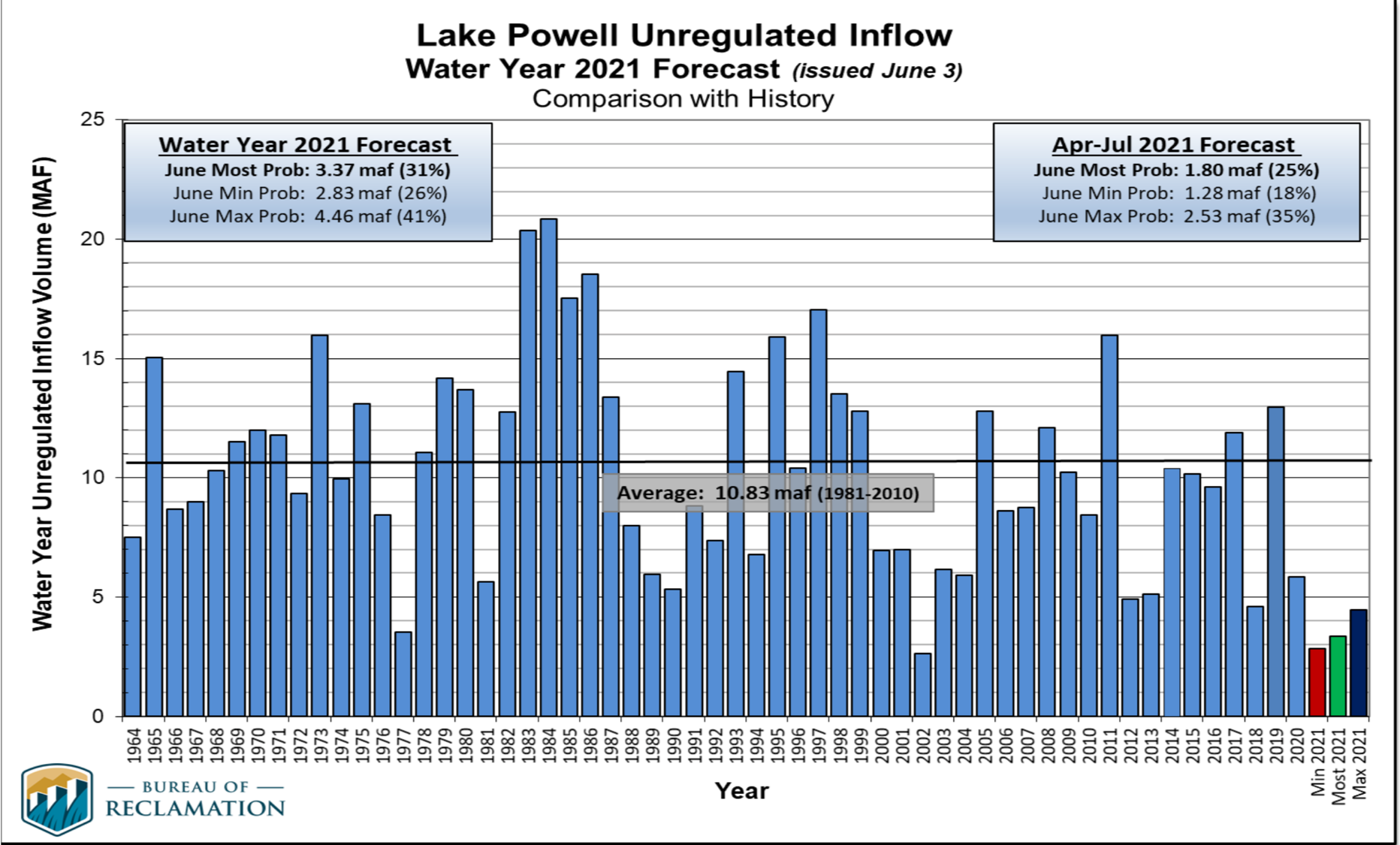
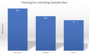
Balancing the river system’s water budget will require deeper cuts in total system water use than now contemplated by the basin Drought Contingency Plans. Further, future conservation targets and reservoir operations rules cannot be static. They will have to accommodate declining long-term average flows and increased variability. There is a general agreement that the post-2026 guidelines should work effectively down to a mean natural flow of 11-12 million acre-feet per year. Nevada’s John Entsminger suggested 11 maf at the University of Colorado’s Getches-Wilkinson Center Conference in 2019 – one of the last and most meaningful public conversations among the basin leadership before the pandemic shut us all down. For comparison, the estimated natural flow at Lee Ferry for the current 2000-2021 period is about 12.4 maf/year.
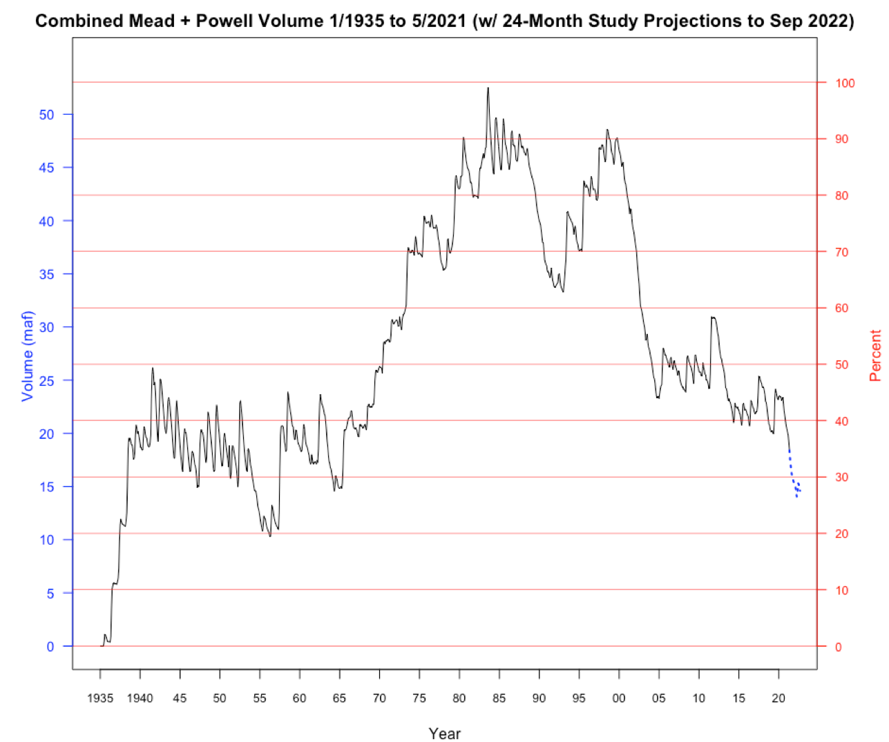
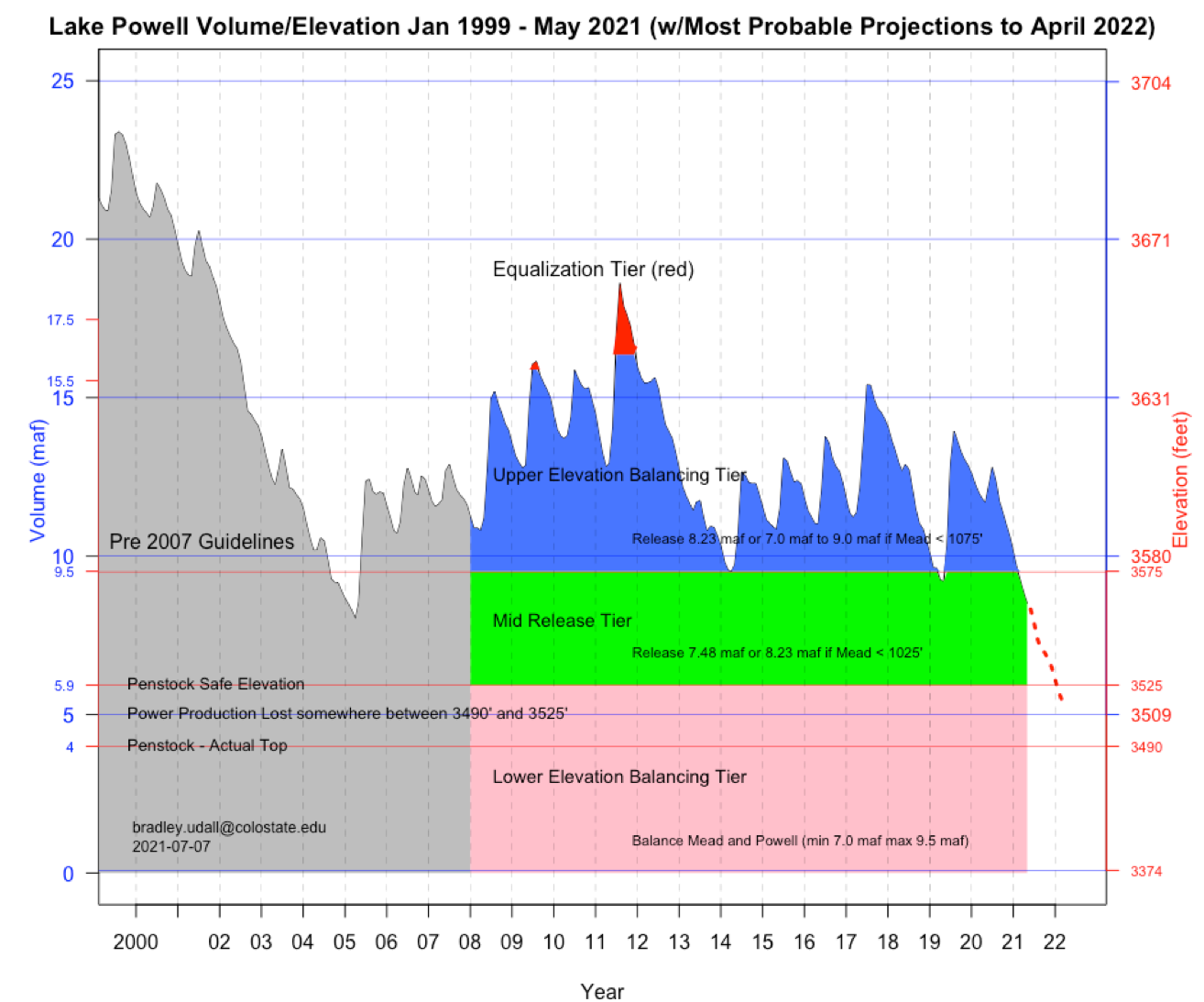
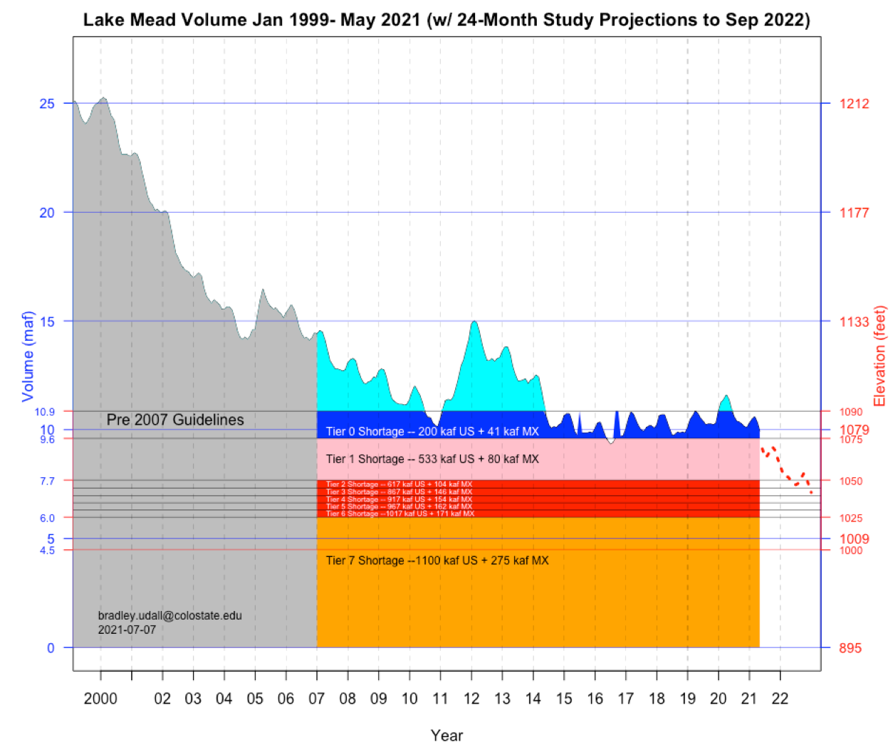
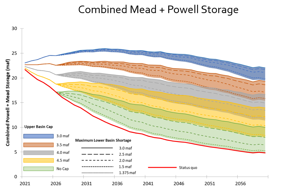
Testing the effectiveness of new guidelines to flow levels below about 12.4 maf/year will quickly and squarely put the basin’s focus on Article III of the compact. The modeling conducted for White Paper No. 6 shows with an average flow of about 12.4 maf/year, and if the Upper Basin average annual consumptive uses do not increase (currently about 3.8 maf/year not counting CRSP evaporation), future combined storage in Lakes Mead and Powell will stabilize, but at a very low level – about 15 maf of total storage. At average flows below this level, unless Upper Basin uses or the flows at Lee Ferry are reduced (thus increasing Lower Basin shortages), total reservoir storage drops to near dead pool levels. With an average Lee Ferry natural flow of 11 maf/year (a plausible future with aridification), and with a Lee Ferry flow target that averages 8.23 maf/year (the minimum objective release target under the 1970 long-range operating criteria and 2007 Interim Guidelines.), total Upper Basin uses would be limited to about 2.5 maf/year – about the same amount of water it was using in 1922, the year the compact was negotiated.
The only way post-2026 operating criteria work for future natural flows of 11 maf/year (and probably any flow below 12.4 maf/year), is for either the Upper Basin States to force large cuts on their existing users or to negotiate a long-term future Lee Ferry flow target well below 8.23 maf/year.
The graph under a climate change scenario with RCP4.5 emissions level – a mid-range estimate of future emissions that shows greenhouse gas emissions beginning to decline by mid-century – and a 6.5% reduction in natural flow per 1 degree C increase in temperature is shown below:
Utah State Colorado River Future Project
Either option, large cuts or a reduced flow target, will require negotiators to deal head-on with Article III of the 1922 Compact- the article that seemingly promises the Upper Basin it can use 7.5 million acre feet of water per year while simultaneously requiring the Upper Basin to send an average of 7.5 million acre feet or more of water downstream to the Lower Basin each year. In a future with a 12.4 million acre foot river, which we have now, or an 11 million acre foot river, which the best climate science suggests it would be prudent to prepare for, the math does not add up.
Some in the water community may argue that the states and Interior are only negotiating reservoir operating rules which have nothing to do with the compact. While it is true that Secretarial decisions normally include pages of legal disclaimer language stating that there is no interpretation of the Compact and most other elements of the law of the river, history tells us otherwise. One only needs to look at the history and plain language of Section 6 of the 1968 Colorado River Basin Act to understand that the 1922 Compact is front and center when the subject is the operation of Glen Canyon Dam, which sits just 15 miles upriver from Lee Ferry. Section 6 requires the Secretary to prepare long-range coordinated operating criteria and annual operating plans for Hoover Dam, Glen Canyon Dam, and the other CRSP storage reservoirs. It also sets priorities for releases from Glen Canyon Dam. The first priority is to meet the obligation of the Upper Basin States under the Mexican Treaty, if any. This is Article III(c). The second priority is meeting the 75 maf every ten years non-depletion obligation, Article III(d), and the third priority is what we refer to as equalization, Article III(e). Long-time Colorado Water Conservation Board Director Felix Sparks described it this way – section 6 was all about giving the Upper Basin certainty under the compact, and “we wrote every word of it.” Of course, in Felix’ day the belief was that the Colorado River at Lee Ferry was a 15 maf/year river, already not enough to meet future needs of the basin, even before climate change began taking its cut (see our book Science Be Dammed, Chapter 15).
Modifying or reinterpreting Article III of the compact to reduce long-term Glen Canyon Dam releases will require either a great deal of ingenuity, creativity, and negotiating skill (and luck) or a blunt-force legal victory in the Supreme Court. The most obvious legal approach is to challenge the Upper Basin’s assumed 750,000 af/year obligation to Mexico under Article III (c). This approach might include a claim that Lower Basin uses in excess of 8.5 maf/year, if any, are surplus waters that should be delivered to Mexico. Legal scholars have been writing about the disputed issues concerning the Upper Basin’s Mexican Treaty obligation for decades. Many, but not all, have concluded that the Upper Basin would have an uphill fight, that such a case would quickly escalate into a broader dispute, and that the result could be that the Upper Basin must deliver more water; 750,000 af/year plus channel losses between Lee Ferry and Mexico. (See for example Jason Robison and colleagues from 2012.)
Any decision involving the future of the compact will be politically difficult. Within the Upper Basin States there are long held and deeply embedded views that the compact protects the Upper Basin from the evil water grabbers in the Lower Basin. After all, it was the upper river that opposed the Congressional authorization of the Boulder Canyon Project Act (Lake Mead) forcing the lower river to the negotiating table. The compact, mostly written by Colorado’s Delph Carpenter, preserves water for future use in the Upper Basin. Without the compact the lower basin states would command the river. When Arizona threatened the pact’s future, the Upper Basin States, led by Carpenter, devised a six-state ratification strategy. After Carpenter, Colorado’s Clifford Stone chaired the Committee of Fourteen that advised the State Department on the Mexican Treaty negotiations and led the fight for Senate ratification. When the Upper Basin states convened to negotiate their compact, Stone described their task as dividing up the waters apportioned to the Upper Basin while meeting their solemn obligations to the Lower Basin under the compact.
Contrast the Upper Basin’s history with that of Arizona and California. Arizona did not ratify the compact until 1944, only after it decided it was in its interest to do so. Today, it boldly proclaims that its Colorado River tributaries (referred to as “in-state rivers”) are not even covered by the 1922 Compact. And, as a practical matter the river is operated that way! California today is a cooperative basin player, but it was not always so. After its major projects were completed in the 1940s, California spent much of the next 50 years opposing just about every Congressional authorization of projects that use Colorado River water in the other basin states, a blatant disregard of the intent and purposes of the compact as provided in Article I.
We must recognize that Upper Basin water officials are in a difficult situation. They face pressures from state and local politicians who feel entitled to the supplies the Compact promised them, even if that water no longer exists – and may never have.
Thus, reconciling the various conflicting statements by Upper Basin water officials is challenging. Some appear to both want a compact that more equitably allocates the impacts of climate change between each basin, but without changing the compact. Others acknowledge that climate change driven flow reductions and future shortages are the most challenging problems facing the basin but continue to insist that as individual states they can irrigate tens of thousands of acres of new lands in the future or develop hundreds of thousands of acre-feet of “unused entitlements.” The political environment for addressing climate change in the individual states is quite different.
Our hope is that collectively, they will be open to a wide range of different future options and that they will pursue different options in parallel. We would also hope that one of those options is to recognize that we now have a fundamentally different river to manage than the one that their predecessors thought they had when the 1922 Compact, 1944 Treaty with Mexico, and 1948 Compacts were negotiated, therefore, managing today’s river may require breaking the chains that unnecessarily tie us to the past.