Lowest flow ever recorded on New Mexico’s Gila River

If my math is correct, flow on the Gila River gauge located near Gila, New Mexico, dropped today to the lowest ever measured, in a record that goes back 89 years.

The red line is the daily flow, in cubic feet per second, as measured by the U.S. Geological Survey. The cloud of gray lines is each previous year, in a record that goes back 89 years.

Record low flows on New Mexico’s Gila River


As I write this, the flow is 8.42 cubic feet per second. The previous record low came June 22, 2006, at 9.77 cfs. Look at how far that red line has dropped below the gray cloud. This is not simply a bad year. This is a far drier year than anything that river has seen in a very long time.

Some context on central New Mexico’s big June 4 storm

Storms over the plasma clinic in Albuquerque’s near south valley

Out bike riding yesterday morning, my friend Scot and I were watching the radar app and judging wind and storm direction, dodging the occasional raindrops with a spectacular sky around us. (In fact our ride was delayed because Scot had to put the goat in, something about lightning-goat risks.) But despite the stormy show, the morning brought very little rain.

The downpours didn’t start until afternoon, after we’d returned to the safety of our respective homes to enjoy the hailstorm with roofs over our heads. And after an extraordinarily dry water year (the third driest in more than a century of data for Albuquerque) it was most welcome.

But in the grand scheme of things, it wasn’t much at all.

The 0.57″ of rain at the Weather Service Albuquerque airport station brought us up to 1.45″ for the water year (which begins Oct. 1). That’s just 31 percent of average for this point in the year. It lifted us from the third driest to the sixth driest water year in records going back to the 1890s.

Trying to get a feel for the impact on the Rio Grande, I checked the river gauge at Bernardo, which last week had dropped below 10 cubic feet per second of flow. By way of comparison, the median for this time of year is 2,500 cfs, a couple of orders of magnitude higher. Bernardo is down in the reach of the river where we’ve been starting to see drying. It also was at the heart of yesterday’s storm, with 1.5″ recorded in a volunteer’s gauge in Jarales just upstream. The Bernardo gauge got nice bump up to 160 cfs yesterday evening, which is still an order of magnitude below normal for this time of year.

So yes, we enjoyed it. But a line of thunderstorms blowing through on a June afternoon can’t begin to make up for the lack of the widespread mountain snowstorms over the course of an entire winter.


railyard graffiti

ATSF 999794

The artists helpfully made sure the caboose’s ID number was still visible.

update: According to the twitter hivemind (thanks @kzodasnowman and @evanheisman!) the artists leave the numbers exposed (or in this case repaint them in big letters on top of the art) so the railroad people won’t come and paint over the art.

Also, there’s a trainspotting web site with a bunch of pictures of ATSF 999794 through history!

How to crash Lake Mead: Step 1 – crash Lake Powell

A new analysis suggests Lake Powell could crash in less than three years if there were to be a repeat of drought (aridification?) conditions seen in the recent past.

While the basin community’s attention has been focused on the risk of Lake Mead plummeting at some point in the future, Lake Powell at the bottom of the Upper Colorado River Basin is likely to drop 32 feet this year. This is happening in the Upper Basin now, and a couple more drought years could make it scarily worse.

32 feet in Powell is 3.2 million acre feet of water – equivalent to more than an entire years’ use in the Imperial Irrigation District, the largest water user in the Colorado River Basin.

Some work done as part of a new analysis being done by The Nature Conservancy (shared here with permission) shows just how quickly Lake Powell can crash. While discussions about risks to Lake Mead hinge on complicated water policy discussions, the crashing of Lake Powell can be the result of simple hydrology. Simple very bad hydrology that is. But we don’t need scary worst case tree ring stuff or hypothetical climate change hydrology. We just need a repeat of any the three most recent droughts in the last three decades. That’s a discomforting “return interval”, to use the hydrologist lingo.

The difference is that the last three times, the droughts happened with relatively large reserves in the reservoirs. That cushion is gone:

Crashing Lake Powell. Courtesy TNC.

This is the explanation for the “how to crash Lake Mead” graph from U.S. Bureau of Reclamation Commissioner Brenda Burman I wrote about yesterday. That orangy line in the TNC graph models the same period as Burman’s “crashing Lake Mead” graph from yesterday’s post – a repeat of the drought years of the early 21st century. As the levels of Lake Powell decline, under the operating rules less water will be released from Powell into Lake Mead. So as Powell crashes, Mead crashes with it. These two reservoirs, and therefore the fates of water users in both basins, are inextricably linked.

Elevation 3,490 in Lake Powell doesn’t get the same amount of ink that 1,075 or 1,050 or 1,020 in Lake Mead get. But it’s an equally scary proposition. 3,525 is kind of a safety line, like 1,075 in Mead. Below that, we should be very nervous. As the graph in the TNC analysis points out, at 3,490 “Ability to make releases per 2007 Interim Guidelines (and hence Compact Compliance) is jeopardized.”

How Lake Mead could crash

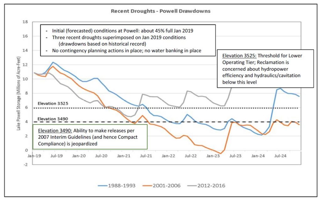
Speaking last week before the Imperial Irrigation District board, Reclamation Commissioner Brenda Burman showed this remarkable slide. It is remarkable for obvious reasons – it shows how easily we could crash Lake Mead! But it’s remarkable in a more subtle way that reflects a shift in our approach to the hydrologic analysis of the Colorado River’s flow, and how we think about risks, probabilities, and the worst case:
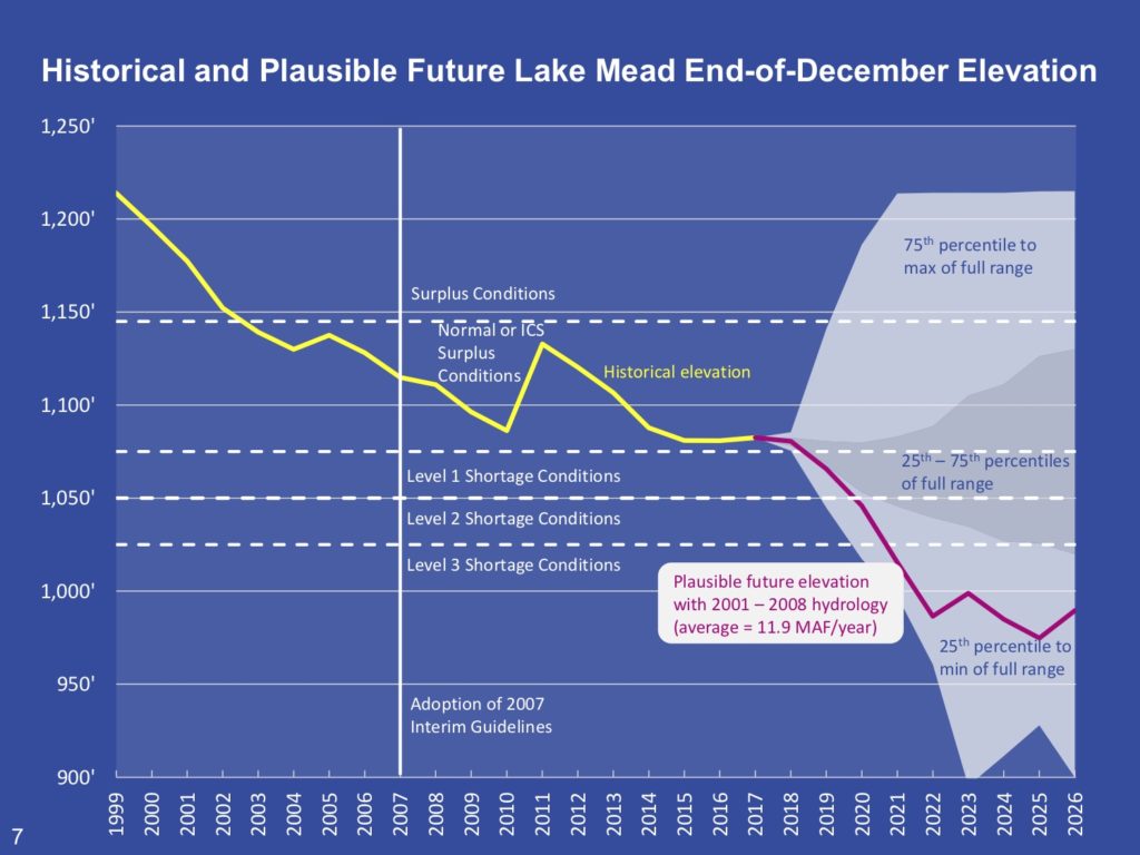
Crashing Lake Mead

Here’s how the Desert Sun’s Ian James, who was at the meeting, explained the first point:

Stressing the urgency of her appeal, Burman showed a chart with a range of possible reservoir levels for Lake Mead in the mid-2020s, including a worst-case scenario in which the reservoir falls to “dead pool” — too low for any water to flow over Hoover Dam. (emphasis added)

The second point is more subtle, involving the decisions embedded in the traditional representations of Lake Mead risk scenarios, and the choice Burman and the Bureau’s staff made in drawing that purply line to illustrate how bad things could get, how quickly.

For the book we’re writing, Eric Kuhn and I have been taking a deep dive into the history of water managers’ measurements of the Colorado River’s flow, and the use of those measurements in decision-making going back a century. One of the critical parameters chosen by decision makers is the “period of record” – what period of river flows do you use as the basis for your decisions?

The gray and light blue clouds shown in Burman’s diagram are a great example of how this works. Those represent the statistics of risk. The grayish bit in the middle, for example, represents a 25 percent risk of Lake Mead dropping below elevation 1,050 in 2020. (That would be really bad!) But what is the universe of possible futures on which that risk is calculated?

The answer (found by clicking on the “download table” link at the bottom of this page) is that the calculation is based on the statistics of Colorado River flow over the period 1906 to 2015. The Bureau this spring did a bunch of hairy calculations involving 3,850 different “futures”, all based on the foundational assumption that the statistics of the future will look something like the statistics of the past. Of course we know that’s not true in a general sense, because climate change mucks up such calculations (see Milly et. al, Stationarity Is Dead: Whither Water Management?). But even independent of climate change, we’ve known for a while that using 1906 to the present as a foundation for Colorado River water management decisions is problematic because of the anomalously wet first 25 years of that record.

To overcome that problem, water managers have been using a “stress test” hydrology, skipping forward to base this type of analysis on a shorter, more recent period of record that ignores some of the older anomalously wet, pre-climate change flows and begins to focus on the era of climate change (shoutout to my book collaborator Eric Kuhn and some other river thinkers in the Upper Basin for pioneering this clever hack).

The purply line on Burman’s slide demonstrates the use of a sort of “super stress test” hydrology as a communication tool, allowing us to focus our attention on a period of time untainted by the anomalously wet years of the early 20th century and fully tainted by the brutal impacts of climate change. It does so without having to invoke the freighted language of future climate change projections, pointing by way of analogy to a period of time in the experience of the people faced with making decisions today. This could happen because the hydrology we’re illustrating has happened in the recent past.

There’s a lot more going on this graph, especially the problems faced by Lake Powell in the purply line scenario. Burman’s purple line only crashes that badly and that fast because Lake Powell is also crashing at the same time. I’d like to come back to that tomorrow, because there’s some interesting new work by folks in the Upper Basin that can help us better visualize that as well.

Record low flows on the Gila

Record low flows on the Gila River in New Mexico

Another of my attempts to visualize data from this remarkably bad water year in New Mexico. The cloud of gray lines is flow at the Gila gauge as the river leaves its headwaters mountains in southwestern New Mexico, one line for each year. The red line is this year – significantly lower than in any of the 89 years of record.

(Code here, modified to plot a log scale on the y axis to make it easier to visualize the low flows.)

Old water – the San Luis People’s Ditch

San Luis People’s Ditch, May 2018

I took the long way home from a meeting in Alamos, Colorado, yesterday to make a pilgrimage to San Luis.

In the Culebra Valley of Colorado in the high country near the New Mexico border, San Luis lays claim to being the oldest town in Colorado, settled by the descendants of Spanish immigrant families. Native erasure notwithstanding, it’s an important claim and an important place. The San Luis People’s Ditch (above) stakes its water rights claim toApril, 1852, the oldest continuously irrigated water rights claim in the state of Colorado. 21 cubic feet per second, 1,600 acres, still running yesterday despite a vicious drought.

What’s left of the Rio Grande

Rio Grande at Interstate 40, Albuquerque, May 21, 2018

I stopped on the Gail Ryba Bridge over the Rio Grande this morning, the bike bridge adjacent to Interstate 40 that offers one of the great views of our river. The morning light was lovely, I saw a couple of egrets in the ditch down below. I love this place.

Flows right now are stable at a bit more than 500 cfs at the gauge just downstream from here. At this point essentially all that water is human water ops. With a terrible snowpack this winter and farm water use to our north in Colorado, the river’s natural flow probably wouldn’t be enough to reach this spot were it not for agricultural water releases by the Middle Rio Grande Conservancy District from El Vado Reservoir, up on the Rio Chama.

This can’t last all summer, and absent a great summer rainy season and/or some creative juggling by the water agencies to stretch out their supplies, this could very well be a view of a dry riverbed by mid-July.